|
By James Tait, 4 Argyll Crescent, Joppa, Midlothian.
[Premium—Forty Sovereigns.]
The county of Lanark, sometimes designated
Clydesdale, is bounded on the east by the counties of West and Mid
Lothian and Peebles, on the south by the county of Dumfries, on the west
by the counties of Ayr and Renfrew, and on the north by those of
Dumbarton and Stirling. Its greatest length from north to south is about
47 miles, and its width from east to west about 32 miles. According to
the agricultural returns issued by the Board of Trade the area of the
county is 568,840 acres; and in extent of surface it is exceeded only by
those of Aberdeen, Argyll, Ayr, Dumfries, Inverness, Perth, Ross and
Cromarty, and Sutherland. Its gross annual value, exclusive of the
municipal borough of Glasgow, as given in the Return of Lands and
Heritages in Scotland, 1872-73, was £1,736,268,
7s., inclusive of Glasgow it was
£4,078,434, which is pretty
nearly thrice the valuation of any other Scottish county. The gross
annual value of Edinburghshire at the same date was £581,603, 6s.,
exclusive of Edinburgh and Leith; including these municipal boroughs the
total valuation of the county was £1,547,435. The next highest is
Perthshire, with a valuation of £959,364, 18s. In 1883-84 the valuation
of Lanarkshire was £2,211,444, 15s. 7d,, an increase of £66,991, 17s.
5d. on the previous year. The census returns for 1881 give the area of
Lanarkshire as 564,284 acres, divided into 41 parishes, besides
fractions of others. There were 180,259 inhabited houses, 193,731
separate families, and 904,412 inhabitants. Of the population 770,314
were resident in towns, 72,197 in villages, and 61,901 in
rural districts. The county contained 1076 persons to every square mile.
Next in density of population were the shires of Edinburgh and Dumfries
each containing 1075 persons to the square mile. Then conies Clackmannan
with 539. The lowest in the scale is Sutherland with 12 persons to the
square mile, and it is followed by Inverness with 22, Argyle 24, Ross
and Cromarty 25, and Peebles 39. The next county to Lanarkshire in
respect of population is Edinburgh, with an area of 231,724 acres, and a
population of 389,164. In 1S71 there were, in Lanarkshire, 147,962
inhabited houses, and 765,339 of a population. In 1861 the population
was 631,566, showing an increase of 272,846 in twenty years. For
parliamentary purposes the county consists of a northern and a southern
division, of which the former is at present represented by Sir T. E.
Colebrooke, Bart., and the latter by J. G. Hamilton, Esq., of Dalziell.
The city of Glasgow has three representatives; and, in the county, there
are the burghs of Rutherglen, which forms one of the Kilmarnock group,
and Airdrie, Hamilton, and Lanark, which are joined to Linlithgow and
Falkirk. For administrative purposes the county is divided into upper,
middle, and lower wards. The upper ward comprehends the twenty parishes
of Carluke, Lanark, Carstairs, Carnwath, Dunsyre, Dolphinton, Walston,
Biggar, Libberton, Lamington, Culter, Crawford, Crawfordjohn, Douglas,
Roberton, Symington, Covington, Pettinain, Carmichael, and Lesmahagow.
The middle ward includes the parishes of Dalserf, Stonehouse, Avon-dale,
Glassford, East Kilbride, Cambusnethan, Shotts, New and Old Monkland,
Hamilton, Bothwell, and Blantyre. The lower ward, lying immediately
around the city of Glasgow, contains Carmunnock, Cambuslang, Rutherglen,
Cadder, Govan, part of Cathcart, and the Barony parish.
Towns.
Glasgow is situated on both banks of the Clyde, in
the parishes of Barony and Govan, with a very small portion of Cathcart.
The Barony parish contains 14,926 acres, and Govan 6733; and the census
returns for the two parishes give the following results:—
These figures include the landward part of the
parishes, and the following give the population of the city for the past
thirty years.
The population of the registration districts was
491,846 in 1871, and 511,532 in 1881. The Barony parish includes the
districts of Maryhill, Shettleston, and Springburn, besides the Barony
proper. Maryhill is partly mineral, agricultural, and commercial. It
includes the town of Maryhill, peopled chiefly by work people, in the
different foundries. The locomotive works of the North British Railway
Company are situated at Cowlairs, in the Springburn district; and the
Saracen Foundry at Possil, equi-distant between Maryhill and Springburn,
employs a large number of hands. A new suburb of Glasgow has sprung up
here, called Possil Park. Military barracks were erected on the banks of
the Kelvin four or five years since; and in these palatial buildings,
Her Majesty's troops are quartered in the order of service. Maryhill was
erected into a police burgh in 1856, and has made rapid progress. The
population of the burgh was 3717 in 1861, in 1871 it was 6659, and in
1881 it had risen to 18,386. In the city portion of the parish, great
changes have been made during the past thirty years. Many old historic
buildings and streets have been removed. Twenty years ago it was found
to be necessary, in the interests of the public health, for the
corporation to purchase, demolish, and rearrange many streets in which
sanitary arrangements could not be carried out. To meet the demand for
house accommodation caused by these changes, new houses were built in
the suburbs. The railway system has tended to promote many changes. The
City Union Railway opened up the dingy quarters of the Briggate, where a
palatial railway station now stands. The Caledonian Railway Company, by
their new line across the river, have removed a once notable business
street. Gallowgate has been almost rebuilt, and the Stobcross Railway,
in the west end, opens up further possibilities of change in that
quarter. The towns in the Barony parish do not now appear distinct from
the city, and their final absorption into one great city under one
municipal authority is probably only a question of time. The parish of
Govan, situated on both sides of the Clyde, is notable for shipbuilding.
Two considerable towns have grown up within the past quarter of a
century, chiefly sustained by that industry. In 1851, the joint
population of Govan, on the south bank of the river, and Partick on the
north, was 3131; in 1861 the population of Govan alone was 7637; in 1871
it had risen to 19,899; and in 1881 to 51,783. In 1861 the population of
Partick was 8183; in 1871 it had risen to 23,837; and in 1881 to 38,985.
South of the Clyde, and on the borders of Renfrew-shire, are the
suburban districts of Pollokshields, Crossbill, Govanhill, and Langside,
which are chiefly inhabited by Glasgow business men. Public parks have
long been a feature of the city. The oldest is Glasgow Green, situated
to the east of the city, on the river banks. At the opposite end of
Glasgow is the West End Park, traversed by the Kelvin, overlooked by the
university, and ornamented with a fountain to commemorate the
introduction into the city of a water supply from Loch Katrine. The town
council have likewise acquired the Botanic Gardens, in the aristocratic
suburb of Billhead; and the Kibble Palace and Winter Garden are situated
there. The Alexandra Park is at the north-east corner of the city in the
Dennistoun district; and in the centre of Crosshill and Langside is the
South Side Park, the site of which is incomparably superior to any of
the others. It would be difficult if not impossible to describe in brief
compass the industries of Glasgow and the enterprise of its merchants,
all dependent more or less directly on the Clyde navigation, itself a
gigantic undertaking. In a paper read at the Naval and Marine
Engineering Exhibition, in 1881, Mr James Deas, C.E., described "the
character and magnitude of those works which have, within the last
hundred years or so, converted the Clyde between Glasgow and the sea
from a shallow stream, navigable only by fishing wherries of at most 4
or 5 feet draft, and fordable even 12 miles below Glasgow, to a great
channel of the sea, bearing on its waters the ships of all nations, and
of the deepest draft, bringing to this city of the west the fruits and
ores of Spain; the wines of Portugal and France; the palm oil and ivory
of Africa; the teas, spices, cotton, and jute of India; the teas of
China; the cotton, cattle, corn, flour, beef, timber,—even doors and
windows ready made,— and the numerous notions of America; the corn of
Egypt and Russia; the flour and wines of Hungary; the sugar, teak, and
mahogany of the West Indies; the wools and preserved meats and gold of
the Great Australian colonies; the food supplies of the sister isle; and
the thousands of other things which go to make up the imports of the two
mile-long harbour of Glasgow (which, until a few years ago, was simply
the river Clyde itself), lined on both sides with wharfs and quays, and
carrying away to India and our colonies—even to Fiji, and to every
foreign land—the varied products of this great city and the whole south
and west of Scotland, from the coal and iron of our mines to the finest
products of our looms and the most improved types of our varied
machinery." Eighty years ago the quayage of the harbour was only 382
lineal yards long, the area of the harbour 4 acres, the revenue of the
Clyde Trust £3400, the customs revenue £427 and the population of the
city 77,385; in 1880 the length of quayage was 4 miles and 382 yards,
the area of the harbour 120 acres, the revenue £223,709, the customs
revenue £956,620, and the population computed at 578,156. "The deepening
and widening of the Clyde have increased the value of the lands on its
sides through Glasgow and seaward a hundred-fold, created the burghs of
Govan, Partick, and the various other burghs that environ Glasgow, given
wealth to thousands, and the means of life to hundreds of thousands;"
and the expenditure up to 30th June 1880 has been £8,786,128, of which
£2,306,766 was paid for interest on borrowed money. The other burghs in
the county contributing to send members to Parliament are Lanark,
Hamilton, Airdrie, and Rutherglen; the burghs of barony are Strathaven,
Biggar, and East Kilbride. The villages and populous places are many.
Estates and Cropping.
From the return of owners of lands and heritages in
Scotland, 1872-73, it appeared there were, outside the municipal
boundaries of Glasgow, 9117 proprietors in the county, of whom 1890
possessed one acre or upwards, and possessed altogether 549,232 acres at
a valued rental of £1,284,592, 18s.; while 7227 owners of less than one
acre had altogether 3865 acres at a gross annual rental of £451,675, 9s.
Inside the municipal boundaries there were 310 owners of one acre or
upwards, who had 3011 acres at a gross annual value of £628,374, 6s.,
and 10,681 owners of less than one acre, who had altogether 2811 acres,
at a gross annual value of £1,713,789, 14s. In all there were within the
municipal boundaries 10,991 owners of 4822 acres, at a gross annual
value of £2,342,164. The municipal boundaries were extended in 1872, and
again in 1878. As might naturally be expected, the rent of land in
different districts varies extremely. In upland parishes land may be
seen at a rent of half a crown to five shillings an acre; in other
places it rents at £6 an acre; while in some localities an acre of land
yields a handsome revenue. Mr Alexander Aikman, Holland Bush, Hamilton,
is entered in the parliamentary return as owner of one acre, which is
rented at £132; and the Airdrie Gas Company is represented as owning one
acre at a value of £700 a year. Within the municipal boundaries of
Glasgow values are much higher. Mr James Arthur, Queen Street, is owner
of an acre which yields the magnificent income of £6923, 10s. a year.
From three acres Sir James Campbell of Stracathro, has £12,912, 5s. of
yearly income. Mr George Martin, 141 St Vincent Street, is on the roll
as owner of one acre, of which the rental is £3928, 10s., other
proprietors of a single acre have from £1000 to £3000 of yearly income.
It will be observed that a large proportion of the
land in the county is owned by proprietors of one acre or upward; and it
may be added that three-fourths of the land are owned by very large
proprietors, while the remainder is parcelled out into moderate or small
holdings. The most extensive landowner is the Earl of Home, Bothwell
Castle, who has 61,943 acres, at a rental of £24,770, besides £4716 for
minerals. The aggregate rent of land in this estate seems to be hardly
8s. an acre. Next in magnitude is the Duke of Hamilton, with 47,731
acres and a rental of £38,441, amounting to fully 16s. 9d. an acre,
besides £56,920, 14s. for minerals. Sir Simon Macdonald Lockhart, Bart.,
of Lee and Carnwath, has 31,556 acres at a rental of £21,050, or fully
13s. 4d. an acre, and £869 for minerals. Sir T. E. Colebrooke, Bart.,
M.P., Abington House, has 29,604 acres at a
rental of £2282 a year, or nearly 7s. an acre. The Earl of Hopetoun,
Leadhills and district, has 19,180 acres, at a rent of £3246, or 3s. 4d.
an acre, and £2246 for minerals. Sir Windham C. J. Carmichael Anstruther,
Bart., Carmichael House, Lanark, has 13,624 acres at a rent of £9228,
and £722 for minerals. Lord Lamington, Lamington House, Biggar, has
10,833 acres, with a rental of £5539, and £788 for minerals. The Duke of
Buccleuch and Queensberry has 9091 acres at a rent of £1544; Colonel D.
C. R. C. Buchanan of Drumpellier, 8549 acres at a rent of £8693, 12s,
and £15,180, 9s. for minerals; R. W. Ewart of Allershaw, Crawford
parish, 8485 acres at £1575; W. E. Hope Vere of Blackwood, Lesmahagow,
6863 acres at £5522, with £5781 for minerals; Mrs Louisa Catterson of
Birkcleuch, Abington, 6870 acres at £1562; William Bertram of Kersewell,
Carnwath, 5863 acres at £2893; the Earl of Eglinton and Winton, 5866
acres at £4097; the trustees of the late Sir W. Stirling Maxwell, Bart.,
Cadder estate, 5691 acres at £8741, with £3231 for minerals; J. W.
Baillie of Culterallers, 4510 acres at £1826; James S. Lockhart of
Castlehill, Carluke, 4422 acres at £5250, and £2183 for minerals. In
addition there are two others who own 4000 acres or upwards,
five others own 3000 acres or upwards, sixteen who own 2000 acres
or upwards, and others of smaller extent. In the county, but especially
in some of the large parishes in the upper ward, there are many small
proprietors, most o£ whom farm their own lands.
According to the agricultural returns issued by the
Board of Trade, the county contains 568,840 acres, of which in 1882
there were 251,121 acres under crops, bare fallow, and grass. Under corn
there were 52,929 acres, of which 3592 were under wheat, 874 barley or
bere, 46,905 oats, 39 rye, 1489 beans, and 30 under peas. Green crop
covered 18,796 acres, of which 7669 were potatoes, 9151 turnips and
swedes, 20 mangold, 51 carrots, 536 cabbage, kohl-rabi, and rape, and
1369 vetches and other green
crops except clover or grass. Of clover, sanfoin, and
grasses under rotation there were 64,713 acres, and of permanent
pasture, or grass not broken up in rotation (exclusive of heath or
mountain land) 113,989 acres. There were 11 acres of flax, and 683 of
bare fallow, or uncropped arable land. Of horses (including ponies) as
returned by occupiers of land, there were 5666 used solely for the
purpose of agriculture &c, and 1944 unbroken horses and mares kept
solely for breeding. There were 64,850 cattle, including 34,483 cows and
heifers in milk or in calf, and of other cattle 10,785 of two years old
and upwards, and 69,582 under two years of age. There were 210,322
sheep, of which 131,046 were one year old and above, and 79,282 under
one year old. There were 7637 pigs.
Geology.
Taking the granite rocks of Galloway as the base,
there are superimposed over them the greywacke and trap which prevail on
the Leadhills and the district adjoining. The pastures of Crawford
parish, chiefly those rocks, thinly covered with soil, are of good
quality, consisting of sweet and nutritious grass. At Roberton there is
a transition to the rocks of the lowland district. About Thankerton are
gravel mounds; and extending in the direction of Biggar is a plain so
little elevated above the level of the Clyde that not much labour would
send that river in the direction of the Tweed. From the western margin
of this plain the Clyde turns north-westward, gently flowing in a wide
valley, across a series of igneous rocks, belonging to the Old Red
Sandstone, which is conspicuous about Tinto. On either side hills rise
with gentle acclivity, those on the south side tending in the direction
of the trap and greywacke, those on the north approaching the great
Lanarkshire coalfield. At Bonnington begin the falls of the Clyde, and,
in a defile through the Old Red Sandstone, the river brawls along for
three or four miles till it tumbles over the last fall at Stonebyres.
From the top of the highest fall to the bottom of the lowest the river
descends 230 feet within a distance of little more than 3½
miles, whereas the fall is only 270 feet in the whole distance of fully
50 miles from Stonebyres to Dumbarton. From Stonebyres downward the
valley broadens, and the course of the river is through the great
coalfield which is the source of industry and wealth to the county. The
coal formation of the middle and lower wards includes bituminous shale,
coal, grey limestone, and clay ironstone, over which there are, in some
places, beds of freestone.
Soil, Climate, &c.
In the report of the Agricultural Commission, 1881,
Mr Hope, one of the Assistant Commissioners, says of the county— " About
one-third under cultivation, remainder unproducing mountain and moorland;
central and western parts generally cold and clayey, with tracts of bog.
South-east part, the soil is light and open, but, from its height,
exposed to frosts. The agriculture is excellent, especially on the banks
of the Clyde." (Report, p. 511). In the upland parishes of
Crawford and Crawfordjohn, as well as the greater part of Lamington and
Culter, the land is high and steep, much of it not susceptible of
agricultural improvement. Three-fourths of Douglas and Les-mahagow
parishes on the one side and of Dunsyre on the other are either moorish,
heathy land, or covered with beds of peat earth, yielding little useful
herbage. Considerable tracts in the parishes of Carluke, Lanark,
Carnwath, Dolphinton, and Biggar are of a similar character. Near the
Clyde it is different even in the upper ward, and there are fertile
districts in all the parishes. In Wiston, Symington, Culter, Biggar,
Covington, Libberton, and Carstairs is a good deal of light, sharp,
turnip and potato soil, which yields excellent crops of these and of
grain coming to maturity about the beginning of September. Some of the
meadows by the river side are exceedingly fertile. In the parishes of
Lanark and Lesmahagow the greater part of the arable land is dry, light,
and friable, but in the latter parish there is clay near the Clyde, some
of which is covered with orchards, and in Lanark there are clay
districts, while the moors are a hard till. Old Red Sandstone is the
prevailing rock. Carluke parish is pervaded, with trifling exceptions,
by a dense blue clay, assuming a reddish appearance in some places,
containing boulders of every size, and from almost every description of
rock, and the soil partakes largely of the same ingredient, acted upon
and altered by the atmosphere, by heat, moisture, and the operations of
the agriculturist. When the rocks crop through this alluvial matter the
soil partakes of the character of the underlying strata, and is
arenaceous over freestone, white or slightly grey earth over fire-clay
or shale, and sometimes a red colour over ironstone. On the Old Led
Sandstone in the southeast of the parish the soil is light, and free in
great measure from clay. Peat soil occurs in different parts of the
parish, but chiefly in the north-west. It overlies the alluvium, except
where limestone and freestone crop out.
In the middle ward the soil varies, but is generally
of a clayey character, a good deal of it with a hard clay bottom
inclined to till; but there are occasional patches of sand or gravel. In
Avondale the soil is light, and is capable of great improvement. The
rocks belong to the coal formation of the second class; and coal, iron,
and especially lime are abundant. Strathaven Moss, extending
to about 200 acres was, half a century ago, utterly worthless;
but it has been drained, and is now yielding splendid crops, some of it
paying £4 of yearly rent per acre. In Stonehouse parish the soil is
generally good. In Dalserf the soil is not well adapted for green crops,
except a tract near the banks of the Clyde, and some patches on the
Avon. Wheat and oats are the principal crops, and turnips were not grown
till within the past few years. Very few sheep are kept, and the chief
industry is dairy farming for the manufacture of butter and cheese. In
Glassford parish there are moss, clay, and light loam. Above 400 acres
of moss are not considered arable; but in a few years this tract may be
under cultivation. In Blantyre parish are mineral deposits, consisting
of coal, freestone, and limestone. At the northern extremity, where the
banks of the Clyde are low, there is an expanse of sandy soil, but
farther east it is strong, deep clay. Toward the south of the parish
there is clay, more light and free than in other parts, but generally
poor in quality. At the south end of the parish is a deep peat moss; and
there are 500 acres of waste and pasture; the remainder is all arable.
Along the west of Both-well, and extending into several adjoining
parishes, is a stratum of new or upper red sandstone. This rock is of a
bright, red colour, sometimes soft and friable, but generally compact
and well adapted for building purposes. Coal abounds everywhere in the
parish, but in the lower division lies at too great a depth to be worked
at present. The coalfield at Law has been estimated to be 53,000 acres
in extent. Iron and limestone abound in the parish. On the north side of
the river, but at some distance from it, resting on clay soil, an
elevated ridge extends along the eastern extremity of Cambusnethan
parish, through the middle of Shotts, where it is high and rocky, and
thence through Monkland parish, declining a little as it advances
westward. Much of the soil in this region is moorish, coarse, and wet.
Dalziell lies in the centre of the great coal district, and abounds in
coal. There is also a flagstone quarry. The soil is chiefly a heavy
clay. There is an expanse of grass land on the holms and haughs near the
Clyde. Old Monkland is superior to other parishes over coal in respect
of fertility; but about 1500 acres are uncultivated, including Gartgill
moss, Lochwood, Drumpellier, and Coatsmuir.
The lower ward is not extensive, but is important in
consequence of being near a large city. A good deal has been improved
and ornamented so as to form summer retreats for prosperous citizens.
With regard to the remainder, the soil consists generally of clay or
sand, naturally very poor. In Cadder parish the greater part of the soil
is of a tilly character.. There are numerous mosses and lochs and a few
good springs, the moss extending to about 300 acres. Great fields of
fire-clay are found near the Glasgow and Garnkirk Railway. The best land
in the parish, part of it on gravel, part on sand, is alongside of the
canal and the Kelvin. In Cambuslang the soil is clay from a few feet to
30 inches thick, beneath which is white freestone twenty feet in
thickness, and then shale to the depth of 30 or 40 feet. Iron and
limestone abound. The whole of Govan parish is arable; and the soil is
of good quality. The Barony parish is diversified in surface, and some
of the low grounds are very fertile. On the whole the district above the
falls is superior to any in the lower part of the county, some parts
excelling in real intrinsic fertility other places 400 or 500 feet less
elevated. The elevation rather than the soil hinders cultivation in the
higher regions, and yet, in some of the highest and wildest districts
there are green spots which indicate the existence of culture at an
early period. Where tillage has not been attempted the pasture has been
much improved by surface draining.
As might be expected from the diversities of
situation and altitude, the climate of the county is varied. The lower
grounds in the west are open to the influences of the Atlantic Ocean,
but the vapours coming from the south-west are intercepted and
condensed by the hills of Renfrew and Dumbarton, and the district about
Glasgow is thereby made rainy but comparatively mild. On the other hand
the force of easterly winds is broken by the higher grounds on the east
side of the county, and the cold fogs which prevail at times on the east
coast are found only to a moderate degree in the west. The greater
amount of cloud, together with the more frequent and heavy rains, is apt
to make the spring late; and when dry weather comes in May and June, as
it often does, with east winds, there is little growth till rain falls
about the end of June. Growth is then rapid, and usually continues well
through the autumn, but the harvest is often late and in danger of being
spoiled by unsettled weather. In the upper ward the moderating influence
of the Atlantic is less perceptible, and the air is purer, but has a
tendency to chilliness; and if the sky becomes clear at night there is
danger of hoar frost except in sultry summer weather. On the highest
hills the climate is severe. Fogs gather round the hills chilling the
atmosphere, summer heat is often interrupted by cold and stormy gusts;
and in winter the hills are often covered with snow for weeks together
when the lower lands have a moderate temperature.
Surface, and Modes of Farming.
In the south corner of the county, bounded on the
south and south-west by Dumfries-shire, is the parish of Crawford, 18
miles long by 14½ wide, and including one of
the wildest districts of the southern highlands. In extent it is larger
than the whole lower ward. The mining village of Leadhills is computed
to be 1300 feet above the level of the sea, and is the highest inhabited
village in Scotland; but the Lowthers, a ridge of hills more to the
eastward, are 1100 feet higher, making a total height of 2409 feet above
the sea level. Among the hills in the east of the parish rise several
important rivers, as indicated in the lines:—
"Avon, Annan, Tweed, and Clyde
A' rise out o' ae hill side."
On its way through the parish, the infant Clyde
receives the Daer, the Elvan, the Powtrail, the Midloch, Camp, Glengonar,
and other tributaries. The village of Crawford, 3 miles south of
Abington, is composed of cottages, built in a straggling manner near the
banks of the Clyde; and the ruins are still visible of the castle once
the stronghold of the Earls of Crawford.
In this extensive parish there are forty proprietors,
and the rental, as indicated by the valuation roll, is £24,229, 2s. The
Duke of Buccleuch owns two farms, consisting wholly of hill land—Kirkhope,
occupied by Mr James Milligan at a rent of £720, and Whitecamp, occupied
by Mr Richard Vassie at £480. Sir T. E. Colebrooke, Bart., MP., has
eight large farms, besides others of smaller size. Normangill is let to
Mr Richard Vassie for £1100; and Crookedstone to Mr John Borland for
£1225. The large extent of meadow and grazing land on this farm, which
is enriched by deposits from the overflowing of the Daer and Powtrail,
enhances considerably the value of the farm. It carries a stock of
blackfaced sheep, which has recently been changed from a Cheviot flock
on account of the severe winters and cold summers lately experienced. It
also carries a large lot of cross and Highland cattle on the holm land.
Castlemains is occupied by the representatives of the late Mr David
Tweedie at a rental of £525; and it carries a good Cheviot stock,
besides a small remnant of a once famous herd of Ayrshire cattle. Other
farms on this estate are let at from £300 to £600 a year. The Earl of
Hopetoun is proprietor of Leadhills, and has a rental of £4045 for lead
mines. He likewise owns several large farms. Glenochar and Glengeith are
let to Messrs Gideon Pott and Mr H. Tait, non-resident tenants, for
£1363. They carry a good stock of Cheviot sheep. The farm of Smith-wood
is let to Mr William Wilson for £725. The farm of Mumerie, on the south
bank of the lower Daer, is one of the most extensive in the parish, is
stocked with blackfaced sheep, and tenanted by Mr Thomas Wilson at a
rental of £1375. The representatives of the late Mr Tweedie hold three
farms at a rental of £1086, 16s. The parish is almost wholly pastoral,
with the exception of cultivated belts along the banks of the Clvde. The
hills adjoining the river are generally grassy, and used to carry
Cheviot sheep; but, owing to the severe winters of the last ten years,
these have largely given place to the hardy blackfaced stock. During the
last ten years fourteen hirsels, containing 8000 sheep, have been
changed from Cheviot to blackfaced in this parish alone.
The area of the parish is 65,400 acres. In 1881 there
were 384 inhabited houses, and a population of 1763; in 1871 the
inhabited houses were 374 and the population 1829. In 1791 the parish
was farmed by 15 store farmers; in 1859 there were 28, of whom 13 who
farmed 40 per cent. of the parish were nonresident. In 1859 it was
estimated that the parish contained 19,500 Cheviot, and 12,000
blackfaced sheep, and 500 feeding sheep. There were 56 shepherds, 18
servant men, 6 lads, 46 women, 8 girls, 2 young horses, 46 farm horses,
11 saddle and harness horses, 302 milk cows, 116 queys, 58 calves, 116
feeding cattle, and 58 swine. These figures are exclusive of the people,
cows, crofts, and kailyards in the village of Leadhills.
The adjoining parish of Crawfordjohn contains 26,357
acres, with a valued rent of £11,099, 3s. a year; and there are 47
proprietors on the valuation roll. In 1881 there were 166 inhabited
houses, with a population of 843, a decrease of ten during the last ten
years. In 1861 the population numbered 980. The parish is about 12 miles
in length, and is drained by the Dun-eaton water which rises in
Cairntable and joins the Clyde one mile below the village of Abington. A
great part of the parish is owned by Sir T. E. Colebrooke, Bart., M.P.,
whose summer residence is at Abington House, adjoining the pretty little
village of Abington, the prosperity and picturesque appearance of which
dates from the accession of the present holder of the Colebrooke estates
in 1838. Sir Edward Colebrooke, who is ably supported by his factor,
John Ord Mackenzie, Esq., of Dolphinton, has greatly increased the
amenity of his estate by many plantations, judiciously placed so as to
combine shelter with picturesque effect. They are intelligently alive to
everything that will improve the estate. The farm steadings are
commodious, and adjoining each of them is a hay shed capable of
containing all the hay produced on the farm, which the tenant finds to
be a great advantage. In the summer of 1883 Sir Edward erected a silo
capable of holding 41 tons of ensilage, on the farm of Nether
Abington, with a view to experiment with the meadow hay as to the
suitability for making ensilage. Large tracts of land have been drained
on the estate within the last thirty years, the proprietor being always
willing to supply the money at 5 and 6 per cent. wherever draining is
necessary. The rental of arable land in the district is about £1 per
acre, green hill 10s., and heath and mountain land from 5s. downwards.
Sheep stocks are rented at 9s. to 10s. for Cheviot sheep, and 1s. less
for blackfaced. There is an agricultural show held at Abington in the
last week of August, open to the adjoining parishes, where there are
annually seen some excellent specimens of the several breeds of stock
for which the district is famous. The farms in this parish are part
dairy, part sheep. Ayrshire cattle alone are reared, and dairies have
from 15 to 40 cows. Young cows are reared to a considerable extent on
every farm, and are kept till they are three years old, when they have
their first calf. The milk is manufactured principally into cheese in
summer, and sent to Glasgow during winter. The cheese consists of
Cheddar and Dunlop. The sheep stock consists of both Cheviot and
blackfaced; but, with a few changes from Cheviot into blackfaced in
recent years, the hardy breed now predominates. The most notable farm on
the estate is Nether Abington, tenanted by Mr John Morton at a rent of
£550 a year, on which great improvements have been made, to be
afterwards noticed. Among others are Crawfordjohn farm let to Mr Edward
Watson for £380, Over Abington to Mr James Paterson at £346, 6s.,
Gilkerscleuch Mains to Mr Thomas Inch at £354, 13., Liscleuch to Mr John
Williamson at £373, 12s., and Boghouse to Mr Alexander Dalgleish at
£358. The Earl of Home has several large farms, including Netherton and
Blackhill let to Messrs David and John French at £980, and Stonehill to
Mr Ebenezer Ritchie at £645, 13s.
In the west of the upper ward, 12 miles long by 4 to
7 miles wide, and extending from the county of Ayr to the river Clyde,
is the parish of Douglas, including the fertile and beautiful vale of
Douglas water, but consisting chiefly of high hills covered with grass
to their summits, and stretching away into moorland wastes so extensive
that there are said to be over 25,000 acres of moor in the parish. The
fertile vale of Douglas water, however, maintains the character bestowed
long ago, as "a pleasant strath, plentiful in grass and corn." This
stream, one of the largest tributaries of the Clyde, rises in Douglas
Rig, Cairntable, and after a course of 16 miles, three-fourths of it
through Douglas parish, joins the Clyde, having received some smaller
streams, such as the Monkburn, the Carmacoup burn, the Kinnox, the
Poniel, and others. These all contribute to the beauty, and promote the
verdure of the district. Coal, limestone, and freestone are worked in
the parish, which likewise abounds with marble, Besides the town of
Douglas, which has seven annual fairs, there are the three small
villages of Rigside (inhabited chiefly by colliers) Tablestone, and
Redhill. On the valuation roll are 107 proprietors, many of whom are
owners only of houses and pendicles in the villages; nine-tenths of the
parish are owned by the Earl of Home, as representative of the Barons of
Douglas. The area of the parish is 34,137
acres, and the valued rent £22,496, 17s. In
1881 there were 441 inhabited houses, and 2641 in habitants; in 1871 the
inhabited houses were 420, and 2624 of a population. The hills are
numerous and high, including in the west and north, Little Cairntable,
1693 feet; Douglas Rig, 1454; Parish Holm, 1400; Hareshaw, 1527;
Monkshead, 1594; Hag-shaw, 1540; Commonhill, 1445; and Windrow, 1297; in
the south and east, Northbottom, 1435; Dryriggs, 1443; Auchendaff, 1399;
Kinnox, 1270; Hartwood, 1311; Auchendaff, 1286; and Wild-shaw, 1136. In
the extreme east, but just beyond the boundary, is Cairntable, 1942 feet
high. There is no natural wood of any extent in the parish, but patches
of birch may be found in hollows among the hills. There are, however,
many thousands of acres of plantations, growing larch, spruce, fir, oak,
ash, and elm. There are many extensive farms producing
the finest specimens of blackfaced sheep. On the banks of the
Douglas Water, near the village, is Douglas Castle, an elegant mansion,
surrounded by extensive plantations; and in a park stretching away to
Cairntable, some ash trees are pointed out on which the powerful Earls
of Douglas were wont to hang persons who came under their displeasure.
The spire and aisle of St Bride's Church are still preserved, and in a
vault are the tombs of the family, including "the good Lord James," the
friend of Bruce, and the hero of Castle Dangerous. The remains of
that fortress still exist, near the modern mansion. The policies, grass
parks, and farm of Douglas Castle are placed on the valuation roll at
£1269 a-year; the stables, gamekeeper's house, lodge, and garden at
£250; and the land under wood at £1100. The minerals at Rigside and
Glasphin are let for £1170. In the parish there are at present fully
7000 blackfaced sheep, exclusive of lambs, but they are gradually
increasing; and 5000 Cheviots, exclusive of lambs, but gradually
diminishing. The annual loss by death, exclusive of lambs, is about 2
per cent. of blackfaced, and 4 per cent. of Cheviots. The usual rent per
sheep is 6s. to 12s. on blackfaced and Cheviots. There are no cross bred
lambs except in parks or on some other low-lying land.
Lesmahagow, 14 miles long by 12 miles in width,
extends from the banks of the Clyde, in a series of broad swelling
uplands, to the borders of Ayrshire, where the hills reach an elevation
of 1200 feet. It has an area of 41,299 acres, and the valuation roll
shows a rent of £67,694 a year. In 1881 there were 1877 inhabited
houses, and a population of 9949; in 1871 the inhabited houses were
1364, and the population 8709. There are 501 proprietors on the
valuation roll, many of whom have small holdings. Among the principal
proprietors are John Stirling Alston, Esq.; W. C. S. Cuninghame, Esq.,
of Caprington Castle, Kilmarnock; the Earl of Home; the Duke of
Hamilton; James Charles Hope Vere, Esq., of Blackwood; and the trustees
of the late General Sir Thomas Monteath Douglas of Stonebyres. The
parish is drained by the Poniel, the Douglas, the Logan, the Nethan, the
Kype, and other streams; and along their banks, as well as near the
Clyde, are fine alluvial lands. The village of Lesmahagow is beautifully
situated on the Nethan, 6 miles from Lanark; and, besides being the
capital of a parish extensive, fertile, and populous, its prosperity is
enhanced by a large cotton mill in the neighbourhood. The other villages
are Kirkfieldbank, Kirkmuirhill, Boghead, Hazelbank, and New Trows. Near
Crossford, on the banks of the Nethan, are the ruins of Craignethan
Castle, described by Sir Walter Scott under the name of Tillietudlem:
and along the banks of the Clyde, from Kirkfieldbank to Crossford are
many orchards. The parish is one of considerable agricultural value. The
orchards near the Clyde contain apples, pears, plums; and gardens yield
gooseberries, currants, rasps, and strawberries. In the higher districts
the crops are late and harvest precarious. The common rotation is the
five or six shift, but freedom of cropping is generally allowed. The
average yield of oats per acre is 4 to 6 quarters, with an average
weight of 35 to 38 lbs. a bushel. The common yield of potatoes is 7 to 8
tons an acre, of turnips 12 to 15 tons, and of hay 2 tons. Grain is sown
in the last week of March and the first week of April, turnips from the
15th of May till the beginning of June. Harvest begins about the middle
of September. The stock consists of Ayrshire cows and blackfaced sheep,
and stock of both kinds has improved during the past twenty-five years.
There is now less cropping and more cattle kept; and they are much
better fed and sold younger. A good deal of land has been drained, the
proprietor giving the tiles; and steadings and fences are generally
good. Servants are generally lodged in the farm houses, and the wages
are at least a third more than they were thirty years since. Bents from
1850 till 1870 rose 30 to 50 per cent., but where leases have been
renewed lately there has been little or no change. The chief dairy
produce of the district is Dunlop cheese.
In early times Lesmahagow was a place of considerable
consequence. In the year 1144 David I. granted the church of that place
as a cell to the abbey of Kelso, and, by the same charter, conferred on
it the secular privilege of sanctuary, within a space marked by four
crosses, in these terms,—"whoso, for escaping peril of life or limb,
flees to said cell, or conies within the four crosses that stand around
it; of reverence to God and St Machutus, I grant him my firm peace." The
"king's peace" was a privilege attached to the sovereign's court and
castle, but which he could confer on other persons or places; and the
penalty for raising the hand to strike within the king's girth was four
cows to the king, and one to him whom the offender would have struck.
For slaying a man "in the king's peace" the forfeit was nine score cows
to the king, besides "the assythment" or composition to the kin of him
slain "after the assise of the land." The pastoral character pertains
largely to the parishes of Roberton and Wiston, Lamington, and Culter.
The united parish of Roberton and Wiston, on the west bank of the Clyde,
is 5½ miles long by 2½
in width, with an area of 13,140 acres, of which 4606 acres are arable,
and 7976 heathy pasture. The valuation is £8636, 7s. There were 116
inhabited houses in 1881, and 562 inhabitants; in 1871 the houses were
135, and the inhabitants 680. In 1861 the population was 786. The parish
has a hilly surface, rising from the Clyde toward the north, where Tinto
forms the boundary. The farming is dairy and pastoral, most of the sheep
being blackfaced, varied with a few flocks of Cheviots. The Earl of Home
is the chief proprietor. Mr Johnston Ferguson, Wiston Lodge, owns
several farms, and has a residence at the base of Tinto. Mr M'Queen
Mackintosh also has several farms, and has his comfortable looking house
on the banks of the Clyde, close to Lamington Station.
The united parish of Wandell and Lamington, on the
southeast bank of the Clyde, is 9 miles long by 4 in width, with an area
of 12,820 acres; and a valued rent of £8293, 14s. It contained 62
inhabited houses in 1881, with 316 of a population; in 1871 there were
63 inhabited houses, with 332 inhabitants; in 1861 the population was
380. The parish has an upland surface, rising to a height of 1300 to
1400 feet; but there are arable haughs near the Clyde, 400 acres in
extent, besides patches of holm land scattered here and there. Many
streams well stocked with trout flow down from the hills, and are
attractive to anglers. At Lamington village is a station of the
Caledonian Railway. The holm or level land is well cultivated,
diversified with hillocks and gracefully adorned with trees; the hills
are smooth and dry, and afford excellent pasture. In the holms the soil
is generally a deep rich loam, and toward the hills a free and kindly
soil. An embankment along the Clyde, the whole length of Lamington
parish, was constructed in 1835-36 at a cost of £2000, and gives great
protection to the holm lands. Dairying and sheep breeding form the usual
routine of agriculture in the parish. The sheep are blackfaced. On
account of the expense and the difficulty in securing efficient
management of the dairy in recent years several herds have either been
greatly reduced, or have given place wholly to the more easily managed
woolly tribe. Lord Lamington owns fully half the parish, and has a
stately house near the village of Lamington, the surroundings of which
have been greatly beautified by the present holder of the Lamington
estate.
Culter, in the south-east part of the upper ward, is
7½ miles long by 3½
wide, with an area of 10,175 acres, and a valuation of £7000, 3s. There
were 92 inhabited houses in 1881, with 428 inhabitants; in 1871 the
houses were 98 and the inhabitants 447. In 1861 the population was 484.
There are on the valuation roll eleven proprietors, the principal of
whom is John Menzies Baillie, Esq., of Culterallers. Part of the parish
is well wooded, but toward the south, where it forms the watershed with
the county of Peebles, the hills are high and bare. The farm of
Culterallers, on which is a notable stock of blackfaced sheep, is let,
along with Snaip, to Mr Robert Watson for £724. The house and home farm
of Culter Maynes are on the east side of the Clyde, and the grass parks
are let for £660 a year. Mr D. Sim, the proprietor, constructed high
embankments, thus adding to the value of the rich holms by protecting
them from the river floods. There are about 2100 acres of heathy
pasture, most of it rough; and in 1859 it was calculated that the parish
contained 6000 Cheviot and 5500 blackfaced sheep, 538 cows, 212 queys,
162 calves, and 132 horses. On the estate of Culterallers, near the
mansion, is a maple tree, which, in 1800, measured 8 feet in
circumference at 3 feet above the ground; in 1835 it measured 10 feet,
and was believed to be the largest tree of its kind in Scotland,
excepting one at Roseneath in Dumbartonshire. A limb has been broken off
since then, which weighed from 20 to 30 cwts. The present measurement is
about 9 feet, and the only limb left is a little over 6 feet at 3 feet
above the trunk. It was considerably more, but by the fall of the limb
the trunk was divided almost right down the centre. Great efforts have
been made to save the remainder by covering it with zinc, then removing
the covering and cleaning and painting the broken part; but now, though
apparently healthy in foliage, it is open from the break to the ground.
A young tree grown from seed of the large one was planted in 1882.
Pettinain is a small parish with an area of 3900
acres and a valuation of £4800, 10s. In 1881
the inhabited houses were 59 and the population 360; in 1871 there were
67 houses and a population of 366; in 1861 there were 407 inhabitants.
The parish is 3 miles long from north-east to south-west, with an
extreme width of 2½ miles. The surface is
uneven, and Westraw Hill attains a height of 1000 feet. The soil is of
various qualities in the low grounds; in the uplands it is moorish. The
village of Pettinain is situated on the banks of the Clyde, 4 miles east
of Lanark, and is within easy reach of Carstairs, Carnwath, and
Thankerton stations. Westraw House, in this parish was the residence of
the last Earl of Hyndford, who took much interest in the agriculture of
the district; and in the parish there are still some good and well
managed farms.
Carmichael parish is 5½
miles long by 3 to 4½ in width, and has an
area of 11,314 acres, with a valuation of £9967, 1s. In 1881 there were
141 inhabited houses, and a population of 770; in 1871 there were 132
inhabited houses and 708 of a population. In 1861 the population was
886. There are 8 proprietors on the valuation roll, but some are small,
and nearly the whole parish belongs to Sir W. C. J. Carmichael
Anstruther, Bart., and the Earl of Home. The parish has a very
diversified surface, extending from the Clyde, where it is joined by the
Douglas water, to the top of Tinto, 2316 feet high. Except Tinto, the
elevations are not great; and there is a gradual transition from the
wild grandeur of the pastoral region to the greater mildness and
fertility of the middle ward. The soil in general is light and friable,
and near the Clyde is fertile. The farms are of moderate size, few of
them exceeding £200 a year of rent, and the amount per acre is from £1
to £1, 10s.
The neighbouring parish of Symington, likewise on the
left bank of the Clyde, has an area of 3504 acres and a rental of £6496.
In 1881 there were 108 inhabited houses and 462 inhabitants; in 1871 the
inhabited houses were 184, and the inhabitants 442. In 1861 the
population was 528. The parish contains some arable and fertile land
near the Clyde, which now gently glides with many windings through a
tract of alluvial meadows; and westward it extends to the top of Tinto.
There are twenty-five proprietors on the valuation roll, with some good
sized farms; but there are many remnants of old pendicles rented at £16
to £45; and the aspect of the parish, with thatched homesteads and byres
in a line with the houses, indicates the existence of some farmers who
do the whole farm work by themselves and their families.
On the opposite bank of the river is Libberton
parish, with an area of 8231 acres, and a valued rent of £8105, 12s. In
1881 there were 114 inhabited houses, with a population of 625; in 1871
the houses were 123, and the population 691. In 1861 the population was
836. The parish includes some fine haugh land along the banks of the
Clyde and its tributaries, the north and south Medwyns, but towards the
east it is more elevated. There are 20 proprietors on the valuation
roll, the principal of whom are Sir S, M. Lockhart, Bart., John George
Chancellor, Esq., of Shieldhill, and the Society for the Propagation of
Christian Knowledge. The estate of Shieldhill has a gross rental of
about £2000, and the average rent of the estate is about £1, 10s. per
acre. The gross rent has increased about £400 in the last twenty-five
years. In the same period about 300 acres on this estate have been
reclaimed at a cost of about £15 an acre, and 450 acres have been
planted. Twenty years ago Mr Brown, of Libberton Mains farm, on the
Carnwath estate of Sir S. M. Lockhart, Bart., incurred the expense of
building large tanks and erecting a steam-engine for the purpose of
utilizing the liquid rejected by the dung heap. His idea was that about
six acres of land in grass near the steading were sufficient to absorb
beneficially all the liquid manure on his farm of about 700 acres, on
which the whole straw and turnip crop were consumed. This arrangement
lasted for some years, but has long been discontinued.
Covington parish has an area of 5114 acres, and a
valued rental of £6725, 11s. In 1881 there were 104 inhabited houses,
and 444 of a population; in 1871 the houses were 104, and the population
454. In 1861 the population was 532. The chief cause of the decrease of
population in this and neighbouring parishes is the failure of hand-loom
weaving, at one time the only industry competing with farm labour, but
now almost unknown owing to the introduction of power looms. In the
parish there are 17 proprietors on the valuation roll, but most of them
are only feuars of a house and garden. There are only four proprietors
of any extent; of whom the principal are Sir W. C. J. Carmichael
Anstruther, Bart., and Sir S. M. Lockhart, Bart. There is a considerable
extent of flat land of good agricultural value, and the upland slopes,
which attain no great elevation except on the sides of Tinto, are
clothed with grain and green crops alternating with sound pasture. Near
the kirk, and surrounded by noble old trees, are the ruins of Covington
Tower, an ancient fortress of the Lindsays; and near it an ancient
dovecote also of great age, to which the only access for pigeons is from
the top. It is inhabited by hundreds of pigeons. The farm of Covington
Mains, conjoined with Covington Mill, both on the estate of Sir S. M.
Lockhart, Bart., is farmed by Mr Allan M'Lean, and carries a good dairy
stock. The neighbouring farm of Meadow-flatt is held by Mr Hugh Lindsay.
The buildings are excellent, and the steading is finely situated on the
south slope of a hill looking out on Tinto and the mountainous district
of the upper ward. There is a breeding and feeding stock of sheep and
cattle on the farm, which is in all respects well managed. As an
indication of the good feeling which exists between landlord and tenant
on the estate of the Lockharts of Lee, it may be stated that the farm of
Meadow-flatt has been held by the Lindsay family for five generations,
or over 160 years, and that the present occupant, Mr Hugh Lindsay, till
four years since, held the adjoining farm of Covington Mains, which had
also been for five generations in possession of his ancestors in the
female line, named Prentice. Among other prominent farms in the parish
are Covington, Hillhead, let to Mr Archibald Stodart, and Lower and
Upper Warrenhill, let to Mr John Tweedie for £285, and Sheriff-flatts to
Mr William Bell at £450.
Biggar parish is on the east border of the ward,
adjoining the county of Peebles. It has an area of 7272 acres, and a
valued rental of £14,774. In 1881 there were 466 inhabited
houses, and a population of 2128 ; in 1871 the houses were 354, and the
population 2013. In 1861 the population was 1999. There are 185
proprietors on the valuation roll, of whom the greater proportion are
small. In the Old Statistical Account, 1791, it is reported that "the
land in the neighbourhood of Biggar is mostly distributed in small farms
of £10 and £15 each; in the country parts of the parish some farms are
let at £50, and others at £70, and one at £150." With the beginning of
this century improvements were rapid. New steadings were built, drains
were cut, dykes were constructed, and hedge-rows were planted. Two
thousand acres of land very soon assumed a new aspect, and became
greatly increased in value. From Boghall to Broughton Bridge, a distance
of 4 miles, the Biggar water was deepened 2 feet, by which it was
estimated that 500 acres of land were increased £1 an acre in value.
Even the climate has been improved by the drainage of extensive
morasses, executed by various proprietors. The soil in the parish
includes clay, sand, gravel, loam, and peat moss. It carries good crops
of oats, barley, peas, turnips, and potatoes, but is not well adapted
for beans and wheat. The dairy has long received much attention ; and
most of the farmers have a stock of milk cows, the butter and cheese
produced from which are much esteemed. The valley is 628 feet, and the
town 695 feet, and the hills 1190 to 1260 feet above the sea level; one
result of which is that the atmosphere is keen, and the winters severe;
but the air is neither so damp nor so cold as might be expected, as the
climate is equally beyond the range of easterly harrs from the German
Ocean and excessive rains from the west. So level is the valley that the
Biggar water, from its source to its junction with the Tweed at
Drummelzier, has a fall of only 25 feet. There are no natural woods, but
remains of alder, oak, and birch are dug up from the mosses, and hazel
nuts have been discovered several feet below the surface. In modern
plantations the ash and elm are the favourite hardwood trees, after
which are the beech and the plane. The general rent of land in the
district is about 25s. an acre; and the rotation extends to six or seven
years. The style of farming includes a portion of grain, turnips, and
potatoes; a dairy; some feeding cattle, a few feeding sheep, some young
calves reared, and lambs bought, fattened, and sold in the best market.
There has been considerable improvement in the stock, and the tendency
at present is towards more feeding with less dairy farming.
The north-eastern extremity of the county is occupied by the parishes of
Walston, Dolphinton, and Dunsyre. Walston has an area of 4366 acres, of
which nearly 3000 are arable. In 1881 there were 74 inhabited houses,
and 340 of a population; in 1871
the houses were 78 and the
inhabitants 425. The most extensive proprietor is Sir S. M. Lockhart,
Bart. The valuation is £3349, 18s.
Dolphinton, in the north-east angle of the county,
has an area of 3574 acres, and a valued rental of £3517, 11s. In 1881
the inhabited houses were 49 and the population 292; in 1871 there were
50 inhabited houses and 231 of a population. In 1861 the population was
260. There are eleven proprietors on the roll, but the great proportion
of the property is owned by John Ord Mackenzie, Esq., W.S., a gentleman
who is factor for several important estates in upper Clydesdale, and to
whose judicious management the upper ward is much indebted. The parish
is picturesquely situated east and north of the Black Mount of Walston
and the hill of Dunsyre, and between the sources of the South Medwyn and
the Tarth waters. The soil is, in some parts, a dry, friable earth or
sandy loam of various depths, but in other places there is clay of a
rusty iron colour. In 1791 the parish was divided into small farms, each
keeping several cottages, in the usual style of that time, but now the
farms have been much enlarged, and are cultivated in the most approved
style of modern agriculture, in which there is cordial co-operation
between proprietor and tenant. Dolphinton House is a handsome mansion
situated in a well wooded park. Near Garvald House the South Medwyn
water separates into two streams, one flowing toward the Tweed, the
other going to join the Clyde. The fork in the stream where the division
takes place is called the Salmon Leap; and it is alleged that salmon and
salmon fry killed above the falls of the Clyde may have got into that
stream from the Tweed by way of the Lyne, the Tarth, and the Medwyn, or
by Wolfclyde Bridge, near Biggar, where the waters of the Clyde, when in
flood, pass into a feeder of the Biggar water and thence into the Tweed.
The parish of Dunsyre has an area of 10,743 acres, of
which about 2000 are arable, and 8000 are heath or rough pasture; the
valuation is £6425, 19s. In 1881 there were 44 inhabited houses, and 254
of a population; in 1871 the houses were
50, and the population 302; in 1861 the
population was 312. Nearly the whole parish belongs to Sir S. M.
Lockhart. The hill of Dunsyre, 1313 feet high, is the southern terminus
of the P'entlands, and is composed of stone similar to that of Arthur's
Seat or Salisbury Crags. The South Medwyn water rises from the
Craigenvar hills in the parish of Linton, but soon turns westward into
Dunsyre parish, where it is joined by the West-water, a stream of nearly
equal volume coming south from the Black and Bleaklaw hills. So flat is
the vale between Dunsyre and Walston that the Medwyn water falls only 15
feet in three miles. It is a sluggish stream, but good for anglers, the
trout being generally red, of considerable size, and
superior in quality to those of the Tweed and Clyde. Pike of large size
are found in the deep pools. Great improvement has resulted from the
straightening of the Medwyn, and the draining of land traversed by it.
In the parish there are beds of pure limestone resembling grey marble;
also ironstone and coal, but they are not wrought. The soil is generally
light and sandy in the eastern district, but, toward the west, the
subsoil consists of clay, sand, gravel, and stones covered with a light
soil that speedily becomes covered with heath unless kept under
cultivation. The system of agriculture consists of stock and dairy
farming, to which cultivation is made subordinate. The rotation of crops
on arable land is the five or six shift. Much attention is paid to the
dairy, and the milk houses are models of cleanliness. Stock has improved
a good deal within the past twenty-five years; and a good deal of land
has been broken up. On the farm of Weston, Dunsyre, within the last
twelve years about 100 acres have been broken up and drained, and nearly
all the arable part of the farm has been limed. Mr Brown keeps feeding
stock, rearing about 15 calves, and purchasing others which are fed off
in two years. The land is generally well watered, the houses are
convenient and in good repair, but the fences are chiefly wire, which is
not considered suitable for horses and cattle. The rent of arable lands
average from 26s. to 30s. per imperial acre. Owing to the lightness of
the soil it is considered that a pair of horses can cultivate 100 acres.
Rents have increased since 1850 in some cases 40 per cent. The hill land
is chiefly heather, but in some cases green mixed with heather; and the
hill sheep are all blackfaced.
Carnwath, about the middle of the east side of the
county, extends from the banks of the Clyde in a northerly direction to
the borders of Mid-Lothian, and is 12 miles long by 8 in width. Its area
is 30,446 acres, and its valuation £42,593, 14s. The number of inhabited
houses in 1881 was 1113, with a population of 5831; in 1871 there were
1073 houses with 5709 of a population. In 1861 the population was 3594.
On the valuation roll appear the names of 240 proprietors, but the
greater part of the parish belongs to Sir S. M. Lockhart, Bart., who has
sixty-five tenants on the roll, some of them with large and good
holdings. The writer of the report in 1791 describes the land near the
village as sandy, with a mixture more or less of black loam; the holms
near the Clyde a deep, rich, clay; those on the Medwyn more inclined to
sand; in the Muirland either a cold stiff clay, or moss with clay or
sand at bottom. In the dale land, as locally named, "the grass is sweet
and good, fit either for rearing or feeding black cattle or sheep" but
"in the Muir-lands much of the pasture is boggy, producing plenty of a
coarse, sour, benty grass calculated better for rearing than fattening
the cattle upon it; and large tracts of such land lie in the course of
the burns which permeate the northern part of the parish." It is added
that "flow mosses abound in the parish 20 to 30 feet deep, much on a
dead level, and irredeemable." In 1834 it was said that "draining has
been executed to a great extent in every part of the parish within the
last forty years;" and "within the last thirty years there has been
taken out of moss and brought into crop from 800 to 1000 acres."
Attention was also given to the stable, the byre, and the barn, but the
farm houses were not considered relatively so good as the steadings.
Since 1834 the parish has been still further improved, and that to a
large extent. According to the Ordnance Survey there are now 16,526
acres of arable land, of moss and rough pasture 4387, meadow 85, heathy
pasture 3117, rough pasture 4066, and wood 1296. One of the largest and
most important farms in the parish is Calla, the property of Sir S. M.
Lockhart, and tenanted by Mr A. Fleming. The farm includes 350 acres of
arable land, with 900 acres of pasture and moor. The farmhouse is
substantial and commodious, and the lawn and adjuncts are kept with
admirable neatness. The steading is stone-built and slated, uncommonly
well arranged and thoroughly substantial. Through the kitchen there is
access to the dairy, and the passage is continued to the byre and over
the whole steading, without the necessity of going outside. The ordinary
produce of the dairy is Dunlop cheese, the making of which is
facilitated by all modern improvements. The byre is 120 feet long, by 21½
feet wide, and 9 feet high, and it is arranged to keep forty cows. The
straw barn and hay shed have easy communication with the byre. Though
surrounded by higher grounds there is no adequate water supply by
gravitation, but water is forced up by a ram from a lower level. The
farm has been occupied by Mr Fleming for a lease of nineteen years, and
about half of a second lease has expired, during which period great
improvements have been made. Much land, formerly moor, has been broken
up, fenced, drained, and limed, and brought under the plough. Part of
the fencing has been done by the proprietor. Some of the fences are
wire, others are stone dykes. The soil is generally light. The rotation
of crops on the arable land extends over eight years usually; but less
is ploughed than there was formerly, and hay is cultivated instead. The
sheep on the hill land are blackfaced ewes, and all the stock of both
sheep and cattle is bred on the farm. They are fed chiefly on the
produce of the farm, but partly and increasingly on cake and meal. The
surplus animals are sold partly at public sales, partly at home.
Another extensive and valuable farm is Lampits, also
in the estate of Sir S. M. Lockhart, and occupied by Mr Mather. Situated
within a mile east from Carstairs Junction, the farm has a good
proportion of holm land, which is liable to be overflowed by the Clyde,
but the steadings on East and West Lampits are finely placed on elevated
sites, and the farm buildings are all in the best style. The farm is
arable with a dairy, but the cows are let to a lower or dairyman.
Mr Purdie Somerville occupies the farm of Muirhouse
on the same estate, but in the parish of Libberton. The stock consists
of cattle, pigs, and sheep; the two former reared on the farm, the sheep
purchased, fed, and again sold. Through better feeding the stock in the
district has improved in recent years. There has been little change in
the system of cropping, but a good deal of moor has been brought under
cultivation; and, on the whole, there is more stock, and better kept.
Mr Anderson, West Forth, has a farm of 300 acres, for
which he pays £394 of rent. About 50 acres of oats are grown each year,
with a proportion of turnips and potatoes; but the principal stock
consists of 52 Ayrshire cows, and the industry of the farm is the
production of butter. The whole produce is consigned to one merchant in
Edinburgh, who pays 1s. 6d. a pound all the year. In winter the cows are
fed on pease meal, hay, and boiled chaff; and Mr Anderson calculates
that the amount paid for feeding is equal to the rent. On the farm there
are 50 acres of natural meadow, and 50 acres improved out of moss, and
sown with Timothy. The meadows are top dressed with 18 to 20 cart loads
of dung to an acre.
The village of Carnwath is a station on the
Caledonian Railway, 7 miles from Lanark and 25 from Edinburgh, and was
doubtless coeval with the first settlement of the Somervilles in the
12th century. In 1451 it was erected a burgh of barony. It was formerly
a quaint, old-fashioned place, consisting of thatched cottages, badly
arranged; but is now a clean little town, half-a-mile long, containing a
double line of stone-built and slated houses, with some specimens of the
older type still left. A mile to the north-west are the ruins of
Cowdailly or Cowthally Castle, the fortress of the Somervilles, on a
promontary projecting into the morass—a dismal tract called Carnwath
Moor—which extends from Causeway-end in Lothian to Carnwath, and through
which the traveller from Edinburgh approaches this part of Clydesdale.
There used to be annual fairs in Carnwath for horses, cattle, and sheep,
but they have fallen into disuse, with the exception of two in the year
for hiring servants. The other villages in the parish are Forth,
Newbigging, and Braehead. In the parish there are quarries of lime and
freestone, and extensive ironworks founded in 1779 by two brothers named
Wilson, who built the village of Wilsontown for the accommodation of
their workpeople. The situation was exceedingly convenient, as coal,
ironstone, limestone, and fire clay were all on the ground where the
blast furnaces were built. The works were purchased in 1821 by Mr Dixon
of the Calder Iron Works.
Carstairs, extending from the north bank of the Clyde
to the borders of Mid-Lothian, between Carnwath on the east and Lanark
on the west, consists of a higher and a lower district, separated by an
elevated ridge. The Mouse water traverses the centre of the parish. The
area of the parish is 9820 acres, of which 6010 are arable, and 1857
rough pasture; and its valued rent is £15,974, 13s. In 1881 the
inhabited houses were 387, and the population 1955 ; in 1871 the houses
were 258, with a population of 1718 ; and in 1861 the population was
1345. On the valuation roll there are fifty-three proprietors, of whom
the principal is Robert Menteith, Esq., of Carstairs. The mansion is an
elegant Gothic structure, situated close to Carstairs Junction, and
surrounded with fine trees. The lawn, gardens, and shrubberies are
extensive and well arranged, but an expanse of rough heather in close
contiguity shows the wild and moorish character of the soil in its
natural state. The home farm is valued at £490 a year, the grass parks
at £600, woods £100, mansion, lodge, and stables at £215. On the east
side of the mansion and grounds, and including in its centre the station
and village of Carstairs Junction, is Strawfrank farm, occupied by Mr
John Allison. Like all farms in the district, Strawfrank includes a herd
of Ayrshire cows, the milk of which is partly sold to villagers at the
junction, and the remainder sent to Edinburgh or Glasgow. Milk can leave
Carstairs at seven in the morning, and the cost of carriage to either
city is 1d. a gallon, which is paid by the sender. The price obtained
for milk is generally 6d. a gallon in summer, and 10d. to 11d. in
winter; from this the cost of carriage is deducted. In the agriculture
of Strawfrank the six shift is adopted, which consists simply of three
years in crop and a like period in pasture. Of green crop there are
about 30 acres in potatoes and 10 in turnips, which is about the reverse
of the proportion usually adopted in the district. Besides farm yard
manure, guano and dissolved bones are applied to the green crop; oil
cake and pease meal are used as feeding stuffs for cows. No barley or
any grain except oats is grown, and the oats are of the Providence
variety, which is most suitable as being an early sort. The yield will
be 6 bolls an acre in an average year, and the weight 36, 38, to 40 lbs.
a bushel. Potatoes yield 7 to 8 tons of good potatoes to the acre. The
soil of the farm is. much mixed. A large tract north of Carstairs
Junction has been taken from moss, and from being a worthless morass is
now fair soil stocked with sheep and cattle. The whole farm has been
drained, but the tiles get speedily filled up with red iron ore, and in
three or four years require attention to keep them in order. Mr Allison
has fenced and irrigated about 30 acres of meadow close to the railway,
which promise a good return. The house and steading are fair; but a new
lease has been negotiated in a friendly manner this year, and money is
to be laid out in improving the buildings. The factor on the estate is
Mr John Ord Mackenzie, W.S.; and it should be mentioned as indicating at
once a conscientious tenant and the existence of his confidence in the
proprietor and factor that no diminution of manure or other
deteriorating influence was allowed to operate toward the close of the
lease.
In the higher district of the parish Mr Eliott-Lockhart
of Cleghorn, and of Borthwickbrae, near Hawick, has six farms, of which
the best is Harelaw, recently rented at £450 a year. In the moorland
district the soil is a mixture of clay and black earth; the dale or low
land generally sharp, sandy soil; but both divisions are of fair quality
and capable of producing good crops in an average season.
The parish of Lanark has an area of 10,385 acres, of
which the ordnance survey gives 7053 arable, 524 heathy pasture, 629
rough pasture, and 1220 under wood. The valuation is £22,029, 3s. In
1881 the population of the parliamentary burgh was 4909 ; of the royal,
beyond the parliamentary burgh, 951; and of the landward part of the
parish, 1706. In 1871 the numbers were 5099, 715, and 2012. In 1861 the
population of the parish was 7891. Lanark is believed to have been the
Roman "Colonia," a station on Watling Street; and the place where
Kenneth II. held a council in 978, Alexander
I. erected it into a royal burgh, and the privileges conferred by him
were confirmed by Robert I., James V., and
Charles I. During the wars with England, as well as afterwards in the
time of Charles II., Lanark was the scene of
important transactions. The town occupies an elevated and healthy site
half a mile from the Clyde, and contains handsome buildings and good
shops. It unites with Airdrie, Hamilton, Falkirk, and Linlithgow in
electing a member of Parliament. The market days are Tuesday and
Saturday; and fairs are held on the Wednesday before the 12th May for
rough sheep and black cattle, on the Wednesday before the 12th August
for horses, and on the previous Monday and Tuesday for blackfaced,
Cheviot, and cross lambs; and on the Thursday after Falkirk October
tryst for cattle and horses. Races take place about 2 miles from the
town on the day after the Whitsunday fair. A mile from the town is the
manufacturing village of New Lanark, founded about 1784 by David Dale,
who built the first of the present long range of cotton spinning mills,
and constructed a subterranean aqueduct 300 feet long, cut through the
solid rock, so as to utilise the waters of the Clyde. The mill was
purchased in 1799 by a number of English capitalists for £66,000, and
entered on a new career under the management of a son-in-law of Dale,
Robert Owen, to whom the town is indebted for its educational
establishments. In 1814 the business was offered to public competition,
and purchased by Owen, for a Quaker company, at £112,000. In 1827 Owen
ceased to have any connection with the village, and the factory passed
into other hands. In 1873 the New Lanark company was entered as
possessing 274 acres of land at a valued rent of £2318. The parish is
noted in connection with the falls of the Clyde.
In 1772 Pennant wrote of the land near Lanark, "much
barley, oats, peas, and potatoes are raised about the town, and some
wheat." The manure most in use was a white marl full of shells, found
about four feet below the peat, in a stratum 5½
feet thick; it takes effect after the first year, and produces vast
crops. The same writer adds that " numbers of horses are bred here,
which, at two years old, are sent to the marshes of Ayrshire, where they
are kept till they are fit for use." The surface of the parish is hilly.
At New Lanark it rises 600 feet above the sea level, and the moor of
Lanark is 150 feet higher. In some parts the soil is free, in other
places stiff, with a retentive clay subsoil; some of the moor is good
boggy land, other parts are hard heather. A common rotation is oats,
green crop, oats, then hay or pasture, and afterwards four years in
grass. Oats yield about 30 bushels an acre, weighing 38 to 40 lbs. a
bushel. Potatoes, manured with 30 cart loads of farm yard manure and 6
cwts of Peruvian guano and bone meal mixed, yield 6 to 8 tons an acre.
Land is rented at £1 to £2, and in some cases £2, 10s., an acre; and
newly reclaimed land, after having undergone one or two rotations, lets
at 10s. to 15s. an acre. With the town of Lanark begins a rapid descent
toward the Clyde; orchards speedily begin to appear, and the banks of
the river are covered with them from Lanark to the parish of Dalziell.
The Mouse water, which rises among the hills on the eastern border of
Carnwath parish, joins the Clyde two miles below Lanark by the romantic
ravine of the Cartland crags.
In the neighbourhood of Lanark are handsome mansions,
including Lee House, the residence of Sir Simon Macdonald Lock-hart,
Bart. The house is castellated in style, and the approach is a fine
drive through a wooded park containing some trees of large dimensions.
In the mansion is the "Lee Penny," a talisman of eastern origin, said to
have been brought from Palestine in the fourteenth century by Simon
Locard, ancestor of the present family.
Carluke, adjoining Lanark on the north bank of the
Clyde, has a generally well cultivated
surface, including orchards which cover 130 acres. The area of the
parish is 15,345 acres, and the Valuation £51,230, 4s. In 1881 the
inhabited houses in the town were 862, with a population of 3867; in the
landward part 868 inhabited houses and 4685 inhabitants. In 1871 the
inhabited houses in the town were 439, and the inhabitants 3423; in the
landward portion 596 inhabited houses and 3645 inhabitants. On the
valuation roll there are 408 proprietors, and the valuation is £40,567.
The Mauldslie colliery is in the parish, and its rent is £2526, 3s., and
another colliery rented at £717, 15s. The Coltness Iron Company is also
in the parish. The valuation of ironstone, limestone, brickfields, &c,
is £821, 12s.; and there are rents paid to the company for quarries of
ironstone, freestone, &c, and for clayfield and workmen's houses. The
Shotts iron works are in the parish, and the valuation of the works at
Castlehill is £900.
The western and larger half of the parish is an
undulating expanse, having a considerable elevation toward the west
called the hill of Mauldslie, beyond which, and within half a mile of
the Lee and the Clyde valley on the south and south-east, the ground
suddenly descends toward the Garion, the Clyde, and the Lee. The eastern
side rises gradually till it is elevated nearly 1000 feet above the sea
level at King's Law and Kilcadzow Law, after which it descends toward
the western boundary of Carstairs parish. The lower and flat part of the
parish is well divided and planted; but the upland, though generally
divided and partially planted, is more bleak, and ultimately runs into
moorland. The most fertile spots are on the Clyde, where the soil,
washed down from the banks, is rich and deep; and to a greater or less
degree, this occurs under all the rising grounds. A valuable bit of
pasture for sheep is at the base of King's Law, 900 feet high, in a spot
naturally bleak and barren, which originates in the shales thrown aside
in working, at a remote period, the limestone found there. The burgh of
Carluke is 5 miles from Lanark, and is a station on main line of the
Caledonian Railway. It has two annual fairs.
In the middle ward the Clyde winds through a fertile
and well wooded valley, the land on either side rising up gradually
toward the moorland. On the southern margin of the stream are the
parishes of Dalserf, Hamilton, Blantyre, Cambuslang, and Rutherglen, and
on its north bank are Cambusnethan, Dalziell, Bothwell, and Old Monkland.
Dalserf parish is 6½ miles long by 4 in width,
with a valued rent of £37,355, 3s.; has a rich
surface generally in a high state of cultivation; and has 50 acres of
orchards besides extensive plantations. The village, one of the neatest
in Scotland, 6 miles from Hamilton, is in a low situation, sheltered by
high banks of the Clyde, and having to the eastward a large fertile
valley called Dalserf holm, round which the river makes a circular
sweep. Other villages in the parish are Millhaugh, Larkhall, Pleasance,
and Rosebank; the inhabitants of which are employed in mines or in
cotton and lace weaving. The parish abounds in coal, limestone, and
ironstone. The great roads from Glasgow to Carlisle, and to Lanark by
the Clyde, and from Edinburgh to Ayr, intersect the parish. In 1881
there were in the town of Larkhall 1115 inhabited houses and 6407 of a
population, in the landward part of the parish 536 houses and 2791
inhabitants; in 1871 the houses in the town were 656 and the population
4885, in the landward portion 402 houses and 2456 inhabitants. In 1861
the inhabitants numbered 4876.
The adjoining parish of Stonehouse has a gently
sloping surface, well enclosed, with considerable plantations and a rich
and fertile soil. The village of Stonehouse, 18 miles from Glasgow, but
close to the Caledonian Railway, has a main street nearly a mile long,
and is mostly inhabited by weavers. The area of the parish is 6241
acres, and the valued rent £13,014, 18s. In
1881 the inhabited houses in the town were 511, and the inhabitants
2615; in the landward district, houses 104, population 538. In 1871
there were 412 houses and 2623 inhabitants in the town, and in the
landward district 100 houses with 554 inhabitants. In 1861 the total
population was 3267. Coal, lime, freestone, and ironstone are found in
the parish, but in thin beds. There are three annual fairs for the sale
of black cattle and wool.
Avondale or Strathaven, a large parish, 13½
miles long by 5 to 8 in width with a valued rent of £40,254, 15s., is
green, fertile, and wooded in the lower district, but with a heathy and
mossy surface in the upland portion. About half the parish is
cultivated, and it has long been conspicuous for dairy produce and the
rearing of calves—the herbage being specially adapted for improving the
beef and milk of cattle. Great quantities of potatoes are also grown.
The town is a burgh of barony, 14 miles from Glasgow, and the
inhabitants are supported chiefly by weaving. The Avon rises in the high
grounds in the borders of Ayrshire, and flows in a northward direction,
receiving many tributary streams, and joining the Clyde a little way
above Hamilton Palace. In the lower district the vale is conspicuous for
pastoral beauty, including splendid old wood and numerous mansions
ancient and modern. The area of the parish is 37,533 acres. In 1881 the
inhabited houses in the town of Strathaven were 562, and the inhabitants
3812; in the landward district 289 houses and 1654 inhabitants. In 1871
the houses in the town were 450, and the inhabitants 3645; in the
landward district houses 299, population 1815. In 1861 the population
numbered 6125.
Glassford, containing the villages of Chapelton,
Westquarter, and Heads, is a parish 8 miles long by 2 miles in width,
with a valued rent of £10,300, 14s., with some
fertile soil near the river, but in the uplands an expanse of moor, a
good proportion of which has been improved. The parish contains 6442
acres. In 1881 the inhabited houses were 265, and the population 1452;
in 1871 the houses 246 and the population was 1430. In 1861 the
population was 1938.
East Kilbride is 10 miles long by 3 in width, has an
area of 22,760 acres, and a valuation of £41,117. It contains the
villages of Auldhouse, Crossbill, Jackton, Braehead, Nerston,
Kiltochside, Maxwellton, and part of Busby. The surface is hilly, with a
large tract of moor; and Eldrig attains a height of 1600 feet. The White
Cart river traces part of the western boundary on the borders of
Ayrshire ; and other streams are the Powmillan, Kittock, and the Rotten
Calder. The roads from Glasgow to Muirkirk, and from Eaglesham to
Hamilton traverse the parish. Dunlop cheese is made in the district, and
a fair for cattle is held annually in May. In 1881 the inhabited houses
were, in the town of Busby, 116, population 620; in the landward
district, houses 646 with a population of 3355. In 1871 houses in Busby
35, population 526; landward district, houses 541, inhabitants 3335. In
1861 the population was 4064.
Cambusnethan parish, on the north-east bank of the
Clyde, extends from the river 12 miles in an easterly direction to the
verge of the county, and contains 16,608 acres with a valued rent of
£85,458, 5s. In the parish are extensive and rich haughs or meadow
lands, well enclosed, varied with good plantations, and orchards noted
for apples. The higher lands towards the east attain a height of 800 or
900 feet. The south Calder forms the boundary between Cambusnethan and
Shotts and the banks of that stream, before its junction with the Clyde,
are romantically wooded. The Garrion burn also flows through the parish,
amid precipitous wooded ravines and a beautiful country. The parish
abounds in freestone, ironstone, and coal. The Shotts Iron Company have
blast furnaces at the village of Stain, in the east end of the parish.
At Wishaw and Coltness are extensive tile works. Cambusnethan or
Wishawtown is a station on the Caledonian Railway, and has an extensive
distillery. The village is inhabited chiefly by weavers. The villages of
Stewarton, Bonkle, and Kircknow are in the parish; and the principal
mansions are Wishaw House, belonging to Lord Belhaven and Stenton,
Cambusnethan House, Allanton, Coltness, and Muir-house. In 1881 there
were in the town of Newmains, including Coltness ironworks, 478
inhabited houses, with 2682 inhabitants; in part of Wishaw 2127 houses,
with 10,782 inhabitants; and in the landward part of the parish 1409
inhabited houses, with a population of 7359. In 1871 there were in
Newmains 444 houses and 2545 of a population; in Wishaw 1435 houses and
8812 inhabitants; in the landward district 1523 houses and 8969 of a
population. In 1861 the total population was 14,601.
In the north-east of the county, having Linlithgow on
its east side, 10 miles long by about 8 in width, and with an area of 24
944 acres, and a valuation of £26,047, is the parish of Shotts. The
surface is generally level, but there are several hills from the summits
of which can be seen the towns of Glasgow, Hamilton, and Paisley; and it
is said fourteen counties can be seen in whole or in part. The North and
South Calders and other streams intersect the parish. The soil is
chiefly clay, with a mixture of loam on the banks of the river, and peat
in places. Near Kirk of Shotts the country has a wild and dreary aspect,
in which all the wealth is underground ; and it is said to be the
highest cultivated land in Scotland. The farm steadings are good and
firmly built, and look as if they included a considerable proportion of
the agricultural value of the land. The prevailing rocks belong to the
Carboniferous formation, and include coal, ironstone, and whinstone; all
of which are worked. In the south side of the parish is a stratum of
fine clay. The parish is traversed by the south road from Edinburgh to
Glasgow ; and by a branch mineral railway in connection with the
Caledonian system. The Shotts and Omoa Ironworks were established in
1757, and are still carried on, furnishing employment to many of the
inhabitants. In 1881 the inhabited houses were 2014, and the population
11,214; in 1871 the houses were 1332, and the inhabitants 8353. In 1861
the population was 7343.
Bordering with the counties of Dumbarton and
Stirling, extending 9 miles from east to west, with an extreme width of
7 miles, an area of 19,885 acres and a valuation of £88,453, 19s. 9d. is
New Monkland, including the parliamentary burgh of Airdrie, and the
villages of Arden, Ballochney, Clarkston, Riggend, and Wattstown. In
1881 there were in the parliamentary and royal burgh of Airdrie 2743
inhabited houses, and a population of 13,363; in the suburban part of
Airdrie 315 houses and 2971 of a population; in the landward part of the
parish 2073 houses and 11,481 inhabitants. In 1871 the parliamentary
burgh had 1167 houses with 13,488 inhabitants; the suburban portion 287
houses and 873 inhabitants; and the landward parts 1050 houses and a
population of 7081. In 1861 the total population was 20,554. The surface
is moderately even, with a gradual ascent of 600 to 700 feet above the
sea-level toward the centre of the parish. It is described in the Old
Statistical Account as " a perfect garden of nature," which seems now an
exaggeration, though the parish, with the exception of a few barren
hills, is moderately well cultivated. The principal wealth is in
minerals, the seams of coal being 9 to 11 feet thick, with ironstone,
lime, and freestone in some places. In and near Airdrie are excellent
mineral springs. The parish is traversed by the middle road from Glasgow
to Edinburgh ; also by the Caledonian and Monkland Railways, which have
stations at Airdrie, and by the Monkland Canal. This was formed in 1790,
and is 12 miles long, going from Airdrie to the Forth Canal at Port
Dundas on the Clyde. It rises 96 feet with eight locks, and falls 21
feet with two locks; and has a reservoir of 300 acres in the parish. New
Monkland at a remote period belonged to the monks of Newbattle Abbey.
Old Monkland, 10 miles in length by 4½
in extreme width, and with an area of 10,935 acres and a valuation of
£167,583 2s. 6d., includes the towns of Coatbridge, Calderbank,
Baillieston, part of Tollcross, and the villages of Braes, Carmyle,
Bargeddie, Cairnhill, Causewayside, Dundyvan, New Dundyvan, Langloan,
Faskine, Greenend, Barackine, Craigend, Merrystone, West Merrystone,
Swinton, Coatdyke, Gartcloss, Gartsherrie, Sum-inerlee, Foxley,
Broomhouse, and Dykehead. In 1881 the population was as follows: —
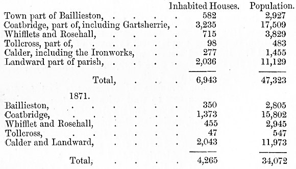
In 1861 the population was 29,543.
The surface is moderately even, and diversified with
orchards and thriving plantations. The soil is generally fertile, and is
much improved by good cultivation. The parish abounds in coal,
ironstone, and freestone, all of which are worked to a considerable
extent. There are potteries, bleachfields, muslin weaving mills, and
dye-works, but the chief industry is connected with the collieries and
mines. Sixty years ago the parish was a rural district; now it is in one
of the richest mining localities in Scotland. The principal foundries
are Gartsherrie, Dundyvan, Monkland, Calder, Clyde, Summerlee, Carnbrae,
and Langloan,
Hamilton parish, about 6 miles square, with an area
of 14,243 acres, and a valued rent of £115,704, 17s., contains the town
of Hamilton, a parliamentary burgh and burgh of barony, besides
Ferniegair and Larkhall. Subjoined are the statistics of the
population:—
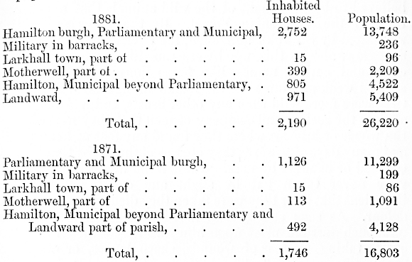
The municipal boundary was extended in 1878. The
total population in 1861 was 14,047.
A clay soil prevails in the uplands, but in the lower
districts the soil is of average quality and well cultivated. The river
Clyde forms part of the north-eastern boundary, and is here joined by
the Avon, which crosses the south-east of the parish. Some small
tributaries of these rivers, abounding with fish, issue from the hills
and traverse the parish in different directions. Limestone, freestone,
whinstone, and fuller's earth are worked, and iron ore and coal are
found.
Previous to the reign of Robert
II. the whole parish was named Cadzow or Cadyow, but the land was
acquired by Sir Walter de Hamildon or Hamilton of Hambleton in
Leicestershire, a descendant of the first Earl of Leicester, who changed
its name to Hamilton. The old village of Netherton was superseded by
Hamilton, which was erected a burgh of regality in 1548, but did not
obtain the parliamentary franchise till 1832, when it was joined with
Airdrie, Lanark, Falkirk, and Linlithgow. The manufacture of lace was
formerly carried on, but it has been superseded by muslin weaving,
cambric spinning, and the manufacture of hosiery. There are likewise
some handicrafts, such as shoemakers, colliers, nailers, and lace
printers.
Not far from the town is Hamilton Palace, a seat of
the Dukes of Hamilton and Brandon, situated in a finely timbered park
formerly called the Orchard. In the same neighbourhood are Cadzow Old
Castle, once a residence of the early Scottish kings, and Chatelherault
Castle, built by Adams in imitation of Chatelherault, in Poitou, which
Henry II. of France gave with a ducal title to
the Earl of Arran. In the park are oak trees said to be the largest in
Scotland, as also a herd of cattle, believed to be a remnant of the wild
animals that once roamed through the Caledonian Forest. By the historian
Boethius, translated by Sir John Bellenden, the ancient breed is
described as follows:—"In this wood were sometimes white bulls, with
crisp and curling manes, like fierce lions; and though they seemed weak
and tame in the remanant figure of their bodies, they were more wild
than any other beasts, and had such hatred against the society and
company of men that they never came in the woods or lesuries where they
found any foot or hand thereof, and many days afterwards they ate not of
the herbs that had been touched or handled by man. These bulls were so
wild that they were never taken but by slight and crafty labour, and so
impatient that after they were taken they died from insupportable
dolour. As soon as any man invaded these bulls, they rushed with such
terrible press upon him that they struck him to the earth, taking no
fear of wounds, sharp lances, or other most penetrative weapons." The
bulls in Hamilton Park resemble the ancient denizens of the Caledonian
Forest in having a white colour with black muzzles, and a black mane
about two or three inches long, and they are fierce, but not so terrible
as one might infer from the description quoted above. The average weight
of those animals is 60 to 80 stones, and the flesh is of excellent
flavour and finely marbled. Some of the bones dug up in Scottish peat
mosses represent a larger style of animal than those now existing.
Blantyre, west of Hamilton, and on the south bank of
the Clyde, is a level and fertile district, well sheltered by higher
grounds. The parish includes the villages of Blantyre, Auchen-raith,
Auchintibber, Barnhill, Hunthill, and Stonefield. The area of the parish
is 3954 acres, the valuation £40,338. In 1881 the number of inhabited
houses in Stonefield town was 784 and the inhabitants 4511; in the
landward district 1027 houses and 5249 inhabitants. The total number of
houses was 1811, and of inhabitants 9760 ; in 1871 the houses were 335,
and the inhabitants 2472. In 1861 the population was 3092. There is
cotton manufacture, which gives employment to about 900 persons. The
district contains ironstone and limestone. There is a mineral well in
the parish, the water of which is efficacious in curing certain skin
affections. In the parish is Erskine House, a seat of Lord Blantyre.
The lower ward is small in dimensions, but of great
importance, lying as it does immediately round the city of Glasgow.
Carmunnock parish is on the east side of the White Cart, the banks of
which are beautifully wooded, and has an elevated surface diversified by
hill and dale. Cathkin braes, 500 feet above the sea level, commands a
rich and varied prospect, extending to Arthur's Seat, the Pentland
Hills, Ben Ledi in Perthshire, and the peaks of Arran and Argyllshire.
The parish contains coal, ironstone, and limestone, The village of Busby
is partly in the parish, and it includes also the village of Carmunnock.
The area of the parish is 3479 acres. In 1881 the inhabited houses were
146, and the inhabitants 722; in 1871 the houses were 116 and the
inhabitants 702. In 1861 the population numbered 734.
On the west bank of the Clyde, beautifully
diversified with hill and dale, is the parish of Cambuslang. The area of
the parish is 5160 acres, the valuation £66,695. Dechmont hill rises to
a height of 600 feet; and Turnlea hill forms a ridge about half a mile
broad, from which the land declines gently, with many beautiful
swellings to the Clyde, now 200 to 250 feet in width, and the Calder,
which bound the parish for several miles. Some small streams, such as
the Kirk Burn, Newton Burn, and Cocks Burn flow through the parish into
the Clyde and the Calder. The parish is part of the great coal basin of
the Clyde, and freestone also abounds. The villages of East Coats, West
Coats, Sauchie Bog, Silver-bank, Lightburn, and Kirkhill are inhabited
almost wholly by colliers and weavers. In 1881 there were in the town
1092 inhabited houses, and 5538 inhabitants, in the landward district
697 houses and 3909 inhabitants. In 1871 there were in the town 214
houses and 2104 inhabitants, and in the landward district 296 houses and
1636 inhabitants. In 1861 the population was 3647.
On the left bank of the Clyde, opposite the Barony
parish of Glasgow, and on the lower slope of the Cathkin hills, 3 miles
long by 1½ in width, with an area of 2151
acres and a valuation of £27,199, is Rutherglen, a parish well
cultivated and containing many fine villas. There is abundance of coal
and freestone in the parish. The burgh, which now consists of one well
paved street, was at one time a place of great
importance; and, in the twelfth century, Glasgow was included in its
municipal boundaries. Rutherglen was privileged to send one member to
the Scottish Parliament; and at the time of the union in 1707 it shared
with Glasgow, Renfrew, and Dumbarton the right of sending a member to
the imperial legislature. The parish was conspicuous for an improvement
of one important implement of husbandry, and Rutherglen ploughs became
well known all over the west country. The style of construction was
designed by Lady Stewart of Coltness, a great promoter of agricultural
progress. The parish is likewise well known for the superior breed of
west country horses reared within it, and the large numbers sold
annually at its spring fairs. The town was at one time notable for the
baking of sour cakes, and the making of salt roasts, previous to St
Luke's fair; and a sour cream with a peculiar gout was made in
the burgh and sold in Glasgow, but these industries have fallen into
disuse. The trade on the river which once existed has now been absorbed
by Glasgow, and the people are now employed chiefly in weaving muslins
for Glasgow houses, in a cotton mill, and in print and dye works.
Subjoined are the statistics of population:—
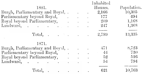
Cadder, a parish 14 miles long with an average width
of 4 miles, an area of 13,969 acres, and a valuation of £52,048, 2s.
4d., extends along the northern boundary of the county,
adjoining-Dumbarton and Stirlingshire, and has a considerable variety of
surface. The river Kelvin, nearly parallel with the Forth and Clyde
canal, bounds the parish on the north. The Edinburgh and Glasgow
Railway, with the Kirkintilloch and Garnkirk lines, intersect the
parish. Freestone and limestone abound, and there are large fields of
fire-clay on the lines of Garnkirk Railway. The parish contains the
villages of Auchenairn, Gadder, Bishop-briggs, Auchenloch, Chryston
Muirhead, Mudiesburn, and Mollendinarburn. In 1881 the population was
6965, the inhabited houses 1345 ; of which 105 houses and 573
inhabitants were in Kirkintilloch and Lenzie. In 1871 the houses were
868 and the population 6430, of which only 11 houses and 81 inhabitants
were in Kirkintilloch and Lenzie. In 1861 the population was 5948.
The remainder of the county is made up of Govan, a
portion of Cathcart, and the City and Barony parish of Glasgow. Govan is
on the left bank of the Clyde, with an area of 6733 acres, and a
valuation of £620,676, 3s, 8d. The surface is flat, and consists chiefly
of a rich fertile soil. The interior is traversed by the roads from
Glasgow to Paisley, and from Glasgow to Kilmarnock and Ayr, as well as
by the Glasgow and Johnstone canal, a branch of the Forth and Clyde
canal, and by two lines of a railway. Connected with the town are
shipbuilding yards, dye-works, silk and cotton manufactories, corn,
snuff, chip, and paper mills, besides other manufacturing
establishments. A valuable coal-field is extensively worked in the
parish; and there are large iron-works and blast-furnaces near Gorbals.
Cathcart is a fertile parish, the northern boundary of which approaches
Glasgow, but the census returns show that only 31 houses and 188
inhabitants of the parish were in Lanarkshire in 1881, and only 25
houses with 167 inhabitants ten years before. The Barony parish has an
area of 14,926 acres. Subjoined is the population of these parishes:—
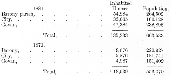
Most of the farms in the parishes of Cadder, the
Barony, and others exhibit a combination of arable with dairy farming;
and the stock consists chiefly of Ayrshire cows and Clydesdale horses.
Farms are generally well managed, and several are conducted on
principles of tidy agriculture unsurpassed in any part of the country.
Among others may be noticed those of High Carntyne, Bruchley, and
Gairbraid. Loehburn, and Westfield, held in one tenancy, have been noted
during many years for the stud of Clydesdale horses. The soil on
Westfield is open and free. Cawdercuilt, on the outskirts of the county,
is held along with Blackhall. In 1881 a great part of it was re-drained.
In some parts the surface soil is mossy, but generally it is a good,
deep, earthy loam. A superior class of Clydesdale mares is kept on these
farms. Cawdercuilt is the largest dairy farm in the district, and has a
stock of 80 to 90 cows, of which the produce is sold as sweet milk. Ten
or twelve years ago the practice was to make butter, but the high price
now paid for sweet milk in Glasgow has' led to a change, and the sale of
sweet milk is the mode of working now generally adopted in the whole
district within easy reach of the city. Thirty years ago there was on
Blackhill a swamp which, in wet weather, became a loch, but this has all
been drained and levelled up, and now forms excellent pasture. The two
farms of Balmuildys are of average merit. Mr M'Farlane, who occupies one
of them, has a good reputation for making butter, and has been awarded
premiums at Glasgow Show. Much of the land about Lambhill is moss, but
in some cases this has been made up and stiffened by mixing it with a
good deal of blaze or the burned refuse of coal pits. In Cadder parish
generally the soil is a stiff clay. The most friable is on the farms of
Milton and East Cadder, where good crops are produced. Lochfaulds is
tenanted by the Carron Company, and is susceptible of improvement as
regards steading and drainage. Fences in the district are fair, but
hedges are often ragged, and patched with paling. Cadder wilderness, at
the back of Hilton, contains 100 acres of plantation. There are also
beltings of wood in the parish, and most of the farm steadings are
surrounded with a few trees. Fields throughout the parish are not
generally steep, but in some parts there are undulations which make a
degree of stiffness in the ascent. The land is very heavily manured,
and, after being drained a first and a second time, was more productive
than it has become now. Prior to the advent of the potato disease the
average yield of that crop per imperial acre was about 18 tons of
potatoes; and from 1836 to 1845 it was one of the most profitable crops.
Tenants are obliged to farm better than they did
twenty-five years since, and to meet the exigencies of higher rents and
increased expenses every inch of land must be utilised to the utmost.
One great advantage possessed by tenants near Glasgow is the facility
for obtaining manure. Those who are nearest the city have the dung
carted to their farms, others who have stations convenient get it by
rail, while a few on the canal banks have it brought in barges. It is
calculated that the best manure costs 10s. a ton by the time it is laid
on the soil, and the quantity applied is sometimes 40 tons an acre.
Another advantage is the opportunities for getting produce sold. The
demand for milk is practically unlimited, and one great object of
farmers near Glasgow is to increase the supply. It is not considered
that dairy stock in the district round Glasgow has improved in the past
twenty-five years. Farmers are now obliged to feed very high, and in
every way increase the quantity of milk produced. In order to keep up
the supply contracted for the animals are unnaturally forced, with
results pernicious alike to the individual animal and to the breed, as
the system of the cows is impaired. Quey calves are kept every year in
the proportion of about 10 to every 50 or 20 to every 90 cows; the
remainder are sold to butchers for about 10s. each. Cows do not now last
so long as they did formerly, nor do they calve quite so early, and they
are rather larger in size. The best feeding material for milk cows is
found to be draff, bean meal, and thirds, mixed with turnips in their
season. Each cow gets 8 to 10 lbs. of bean meal per day. No farmer now
sells sweet milk retail in the streets; it is all sold wholesale to city
dairies.
The compact is made between the farmer and the
dairyman for a year, and the average price is 9½d.
to 10d. per imperial gallon. Prior to the bringing in of milk by railway
a higher price was obtained, but the price in the neighbourhood of the
city was reduced when a supply could be obtained by railway from a
distance. In order to maintain an equal supply cows must be bought in at
all seasons, and winter milkers must be got as early as August. For late
calving cows as much as £18 to £20 must be given, and those are
afterwards fattened for the butcher. The price obtained for the fed
animal has fallen a little since the introduction of the American meat
supply. If farmers contract to maintain a constant supply of sweet milk
it is difficult for them to rear calves, and the most successful
breeders are those who make butter and sell sour milk. In 1850 the price
realised for fresh butter was about 9d. a pound ; for the last ten years
it has averaged from 1s. 6d. to 1s. 8d. A ready demand for butter milk
is found in the streets of Glasgow and suburbs. The usual price is 1d.
per 10 gills.
Much land in the neighbourhood of Glasgow has been
improved within a comparatively recent period. Land that was covered
with heather forty years since is now under cultivation; and rents have
doubled within that period. Draining with stones was practised before
tiles came into use; and a cart-load of stones was calculated to fill
two yards of a drain. Much land has been drained a second and even a
third time since then. Extensive improvements were effected on Hilton
farm during the tenancy of the late Mr Alexander Murdoch, which began 35
or 36 years ago. Cadder Moss, containing 30 or 40 acres, was reclaimed
by the Cadder estate proprietors, and now forms part of Crossbill farm
let at 25s. an acre. Other mosses were drained on what are now the farms
of Lochgrogg, Littlehill, and Crosshill. Light, easy soil predominates
all along the slope extending from the centre of Cadder parish to
Balmuildy, and the earliest farms in the parish are those on the
Kirkintilloch border. The general rule of cropping on the Cadder estate
is the six shift rotation, consisting of two years in grass, then oats,
green crop, oats or wheat according as the soil is clay or moss, and
lastly rye grass, with clover when it is intended for hay, or Timothy
when it is for pasture. In some of the new leases the four year rotation
is allowed, and where no dairy is kept the farms are generally wrought
on this principle.
Farm Buildings, Machinery, Implements.
For considerably over half a century the Highland
Society has given great attention to farm buildings. In 1831 twelve
plans were published, which had been prepared by Mr Waddell,
Berwickshire, an architect of great experience, with the co-operation of
a committee of Directors of the Society. A general principle was adopted
that the most convenient arrangement of the out-houses of a farm is in
the form of a rectangle, the side to the south being open, and the farm
house placed at some convenient distance in front of it. Much has been
spoken and written, and a good deal done in connection with the matter.
since then, but the quadrangular form, modified according to
circumstances, has continued to prevail. In building new steadings,
regard is had to the size of the holding, the kind of husbandry, and the
wishes of the tenant; and generally the plans are calculated on
principles of utility, economy, and comfort. As a rule the farm
buildings are fairly suitable for the locality, and on some estates they
are very good. In the county generally farms are of only moderate size,
and the farmer and his family are intimately associated with the daily
work, so that the farm house must be quite contiguous to the steading,
and not, as in some other counties, pleasantly situated among trees and
shrubs at a distance from the out-houses. In many instances, indeed, the
farm houses are not much more commodious than the best cottages for
working people in some other parts of Scotland. There are, however, many
exceptions, especially on farms of a good size. On the extensive estates
of Sir T. E. Colebrooke, Bart., M.P., the buildings are uniformly good.
The want of cottages in the county has long been a
subject of regret. In 1798 John Naismith wrote,—"It is in vain to say
anything of the ancient cottages of the county, the former nurseries of
field labourers; for they may be said to be now no more; as the few
scattered ones which still remain can scarcely be called an exception.
It having, for a long time been the custom of this county for farmers to
keep only unmarried servants, who are lodged and fed in the house, for
the execution of agricultural labour, the cottages on the different
farms have dropped gradually into ruins, and been removed; and the small
tenements being generally swallowed up in the larger farms, the
cottagers and the farm servants, when they marry and settle, withdraw
from their rural habitations to towns and large villages, to which the
increase of employment also invites them; and their progeny, who
formerly were, from their infancy habituated to the labours of the
field, are mostly occupied in some branch of manufacture; so that the
means by which the necessary supply of labour in husbandry used to be
obtained, is in some measure cut off." Seeing the danger that would
accrue from a scarcity of labourers, some landowners granted long leases
of land on which arose villages, generally by the sides of public roads.
In recent years there has been a tendency to build more cottages, and
make them more comfortable. Still there is much to be done in this
direction.
Lanarkshire has always been ready to adopt improved
implements of husbandry. Before the close of last century the old.
clumsy Scottish plough had been superseded by Small's improved swing
plough, and the Rotheram plough from Northumberland.. An improved
implement made at Rutherglen came into favour, as it proved useful in
turning up the deep soil of the valleys with a strong furrow. Ploughs
were afterwards made of iron instead of wood, and were drawn by two
horses instead of three or four. The cost of the old wooden plough was
about 13s. 6d,; the iron plough cost four times as much, but the
advantages were great in respect both of durability and of ready
adaptation to any approved pattern. The saving was great, as two horses
could do the work previously done by four; and the necessity for a
gadsman or guide to the horses was saved. The plough in common use now
is identical with or similar to Gray's plough, so called from the makers
of the implement at Uddingston. In some districts there is a feeling
favourable to wheels being attached to the plough, which adds so much to
its steadiness that a stout boy can often do the work of a man. Turnips
and potatoes are drilled up with a double furrow plough.
A great deal of spring work is done with the grubber.
The first implement of this kind was known as "Finlayson's Triangular,"
with a wheel at each angle, and drawn by three or four horses; but a
light grubber similar to "Tennant's Patent" is now in general use. This
implement is moderate in price, simple in construction, and so light as
to be drawn easily by two horses. The grubber has almost superseded the
use of the plough in spring for turnip and potato land. In autumn the
land is ploughed with a strong furrow, sometimes with three horses where
the soil and subsoil warrant the practice. In spring the grubber is
sufficient, and overtakes more work, without exposing the soil to the
influence of drought. It is superior to the plough also in freeing the
soil from couch grass and wrack.
The old wooden harrows, with four bills or beams,
containing twenty iron teeth, have been generally superseded by harrows
made of iron, the teeth of which have a considerable bevel forward, so
as to stand at an angle of 70 or 75 degrees with the plane of the
harrow. These are useful for reducing stiff land, as well as collecting
weeds. For heavy land brakes of various weights and construction are
used. Boilers of various construction and weight are used according to
the nature of the soil.
For sowing grain a broadcast machine is used, which
distributes the grain more regularly than the hand, effecting a saving
of seed and economising skilled labour, which is important at a busy
season. Turnips, on all farms of any size, are sown with the
double-drill turnip-sowing machine. For cleaning between the drills the
drill harrow, or hurkle, has been used probably ever since turnip
husbandry was introduced. An improved drill grubber is now used.
Grass is cut usually with a machine drawn by horses.
Horse rakes are in very general use. The first reaping machine used near
Glasgow was by Harvey of Keppock, about 1844. The first that was kept
for permanent use was on Buchley farm about 1860, but they were not in
general use till four or five years afterwards. They are now almost
universal. Potato diggers are in common use; but turnip-lifting machines
have not met with much favour. The thrashing of corn with a flail is now
confined to small farms in the remotest districts. Almost every farm
steading has a thrashing machine, driven by water, horses, or steam; but
a good deal is done also with travelling machines which are easily
obtained, and do the work with rapidity. In connection with dairy
operations efforts are made to economise manual labour; and where butter
is made the churn is generally made to go by some mechanical power.
Roads, Fences, Tillage Operations, Succession of
Crops, Manures.
Turnpike roads were first introduced into Lanarkshire
about the year 1755, when the road from Edinburgh to Glasgow by the Kirk
of Shotts, and by Hamilton to Ayr, were constructed. Great advantages
immediately followed. New houses were built, fields were enclosed and
subdivided, facilities were afforded for the conveyance of produce and
manure; and the general fertility of the district was increased. Other
roads were made, and before the close of the century communication
through the county had been opened up toward many important quarters,
some of the roads passing through districts formerly secluded and
inaccessible. The first made roads were not well engineered, but
generally the direct line between any two points was adopted even though
it led over eminences of considerable height. These mistakes were
avoided in making later roads, such as that from Glasgow by Muirkirk to
Dumfries, that which crosses it at Kilbride, leading from Hamilton to
Ayrshire, and the great road from Edinburgh to Glasgow by way of
Airdrie. Another medium of communication which is even yet important was
by means of canals. The Forth and Clyde canal enters the north corner of
the county, in the parish of Cadder at a point 156 feet above the
sea-level, and goes into Dumbartonshire at the aqueduct bridge on the
Kelvin, after a course of 8 miles in the county of Lanark. A branch goes
off toward the city of Glasgow, and terminates at Port-Dundas, on the
top of a steep hill within half a mile of the city cross. The Monkland
canal was begun under authority of an Act of Parliament, obtained in
1770, and was carried from the centre of the coal works in the parish of
Monkland, on a level of 252 feet above the sea as near Glasgow as the
level would permit. Coals were brought in boats to the extremity of the
canal, thence let down an inclined plane formed of wood, put in carts
and conveyed to the town, The venture was not successful ; and in 1782
the concern was sold by public auction. By agreement with the
proprietors of the Forth and Clyde canal, the Monkland was carried
eastward to receive a supply of water from the North Calder, the source
of which is a lake on the confines of West Lothian, and westward to join
the branch of the Forth and Clyde canal at Port Dundas. Its length is
about 13 miles. It is raised at the west end from Port Dundas by eight
locks 96 feet, and at the east end near Airdrie, by two locks 21 feet,
to bring it to a level with the channel of the Calder. Its width at the
surface is 30 feet, and at the bottom 15 feet; and it is about 5 feet
deep. A more extensive canal is that from Edinburgh to Glasgow, which
passes through the middle of the county, and by which persons still
living have in former days made the journey from the one city to the
other. Canals and roads have their uses; and on some there is a great
deal of heavy traffic; but they are of subordinate importance compared
with railways, with which the county is abundantly supplied, to the
unspeakable benefit of human comfort and commercial progress.
From the middle of the eighteenth century
considerable activity has been manifested in the fencing of land capable
of cultivation. The earliest mode was with ditches having a row of
thorns laid in the face of the mound formed with the earth dug out of
the ditch. This did not prove successful. Sometimes the hedges got
choked with weeds, and in other cases the roots failed to penetrate the
hard soil, which had the effect of making the hedge stunted and puny.
The next plan was to make mounds of earth, collected from the surface,
faced up with stone or green turf, and plant a hedge on the top. The
dyke was about 5 feet wide at the top, and, with a ditch on either side,
occupied about 12 feet at the bottom. On the top was planted a thorn
hedge, sometimes a double hedge, with hardwood trees planted at
intervals between the rows. It became customary to mix the thorns with
beech, as being more hardy, and better fitted
to afford shelter in a stormy country. A fence of this kind, with a
third or a fourth beeches and the rest thorns, was long considered the
best kind of barrier except a stone dyke. But neither was this
altogether successful. In many cases the trees smothered the hedges
which became clumpy; and, while serving purposes of shelter, were
perfectly worthless as fences. But in fact the greater portion even of
the agricultural districts remained practically unfenced till a
comparatively recent period. Thirty years ago a kind of fence largely
adopted consisted of stobs and wire; and about the same time hedges were
planted to a certain extent, and in the pastoral districts stone dykes
were built, more recently there has been a general resort to wire
fencing. On the larger farms these form permanent fences, with larch
stobs and iron standards and ratchets, while on the smaller holdings
they are changed from one part to another as the exigencies of the farm
require. Substantial stone dykes are common in some parishes, and hedges
in others, the latter often lined with wires, but the old feal dykes and
stob and rail fences are now things of the past. In some districts may
be seen patches of. unfenced land under crop; but the difficulty of
obtaining herds owing to the enforcing of the compulsory clause of the
Education Act has made some kind of fence a necessity even on small
farms. On the cultivated land near Glasgow wire fences are the rule, and
in a county like Lanark no kind of fencing could be more convenient.
The arable part of Lanarkshire is under a four, five,
or six shift rotation, the first and third years being under corn, the
second under green crop, and the remaining one, two, or three years
under grass. In the first year the grass is usually, but not always,
cut; after which the land is under grass for summer pasture. "During six
months in winter the cattle are kept within doors. In the southern parts
of the county sheep farming prevails; and, on the other hand, in a
circuit of 10 miles round Glasgow the land is very highly farmed, and
lets at a large rent; a circumstance due naturally to the neighbourhood
of a large town which affords a ready market for commodities, and
supplies unlimited quantities of manures. To such an extent is manuring
carried in that district that one farm of little more than 100 acres
will contract for the dung produced by several hundred horses. It will
be observed that Lanarkshire is notably a county of grass and pasture.
Of 568,840 acres there were 251,121 under crops, bare fallow, and grass
in 1882, leaving 317,719 which may be considered heath or mountain land.
Of the 251,121 acres, however, there were 113,989 of permanent pasture
or grass not broken up in rotation, leaving 137,132 under crop; but
this, again, included 64,713 acres under clover, sanfoin, and grasses
under rotation, leaving only 72,419 acres under crop or bare fallow. Of
this there were 52,929 acres under grain crops, 18,796 under green crop,
11 under flax, and 683 under bare fallow. The extent under oats was
46,905 acres, or very nearly eight-ninths of the whole area under grain
crop. Six Scottish counties have a wider area of oats, but these are
generally larger counties. Aberdeen had 194,103 acres in 1882, Ayr had
52,050, Banff 53,880, Dumfries 49,266, Forfar 53,173, and Perth 71,136.
One reason for the large proportion of oats is that the straw makes good
fodder; but another is that both soil and climate are better adapted for
oats than any other grain crop. The second place is held by wheat; but
the area under wheat is gradually growing less. In 1831 there were 3709
acres, in 1882 only 3592; in 1858 there were 8978 acres. Under beans
there were 1489 acres in 1882 ; barley 682, and small quantities of rye
and peas. Of green crops there were 7669 acres of potatoes in 1882
against 9427 in the previous year; and 9151 acres of turnips and swedes
against 8552 in 1881, There were 1369 acres of vetches and other green
crops, except clover and grass.
Ploughing begins as soon as the potatoes are pitted
in the end of October or beginning of November, and, with occasional
interruptions for the storing of turnips, is continued during the whole
winter when weather will permit. The full benefit of daylight, during
the shortest days, is obtained by doing the thrashing and other barn
work in the early morning.
Wheat used to be sown from the end of August till the
1st of November on fallow or after potatoes, and sometimes after oats,
peas, or beans. Bearded wheat was then common, but afterwards white and
red wheats were introduced, which farmers mutually exchanged with each
other. The fallowed land was manured for wheat with dung from towns, or
with farm yard dung and lime, sometimes with horn shavings imported from
Ireland, and less frequently with woollen rags. To prevent smut the seed
was steeped in a strong pickle of sea salt and water, and dried with hot
lime, sometimes sprinkled with mephitic water from a dunghill, and dried
in a similar way. The quantity sown was from 7 to 12 pecks, Linlithgow
measure, per Scotch acre; and the produce 8 to 16 bolls of the same
measure. At present the yield of wheat near Glasgow is about 8 bolls per
imperial acre, but on the best farms a good average will be 10 to 12
bolls. Wheat straw sells in winter at 6d. a stone; in August 1881 it was
1s. a stone.
Oats are grown after lea, and generally again after
green crops. Providence oats are much used, as a kind that comes early;
but sandy oats grow well near Glasgow, showing a weight of 38 lbs. a
bushel. Oats are sown from the 20th of March till the middle of April,
according to the locality and the season. The first week of April is
usually considered a good time. Harvest usually begins early in
September. Both sowing and reaping have become earlier since drainage
and improved husbandry became prevalent and the increased facilities for
obtaining a change of seed from warmer districts as well as obtaining
earlier varieties have tended in the same direction. In former times the
harvest often extended into November. Oats after lea are often top
dressed with two or three hundredweights of Peruvian guano per Scotch
acre, a practice which increases about one-third the yield of both grain
and straw, and in most cases is found profitable ; the average of soils,
at least in the upper ward, not being of such a character as to lodge
the crop under such a mode of treatment. The yield will be 35 to 45
bushels an acre; the weight 38 to 43 lbs. a bushel. In Hamilton parish 8
bolls an acre are grown ; the average weight 40 lbs. an acre.
Grass and clover seeds are sown with oats after green
crop. Red clover, from its liability to failure for many years, and the
great success of Alsyke, is not sown so extensively as it once was; but
white clover and Alsyke are sown, and Timothy on strong or mossy soils,
especially where sheep are kept. Eye grass is, however, the most
important grass for general use. Italian rye grass is sometimes sown,
especially where there are facilities for irrigation. Sometimes a crop
of tares is considered more profitable than rye grass for soiling or the
house feeding of cattle. The crop of young grass was, at one time,
always cut for hay; but now it is common to pasture it in summer. Hay is
of less consequence as winter food for cattle since the growing Of
turnips became common, as the supply of other fodder, with the aid of
turnips and other articles, is sufficient. The quantity of hay has
likewise been largely increased; and by the application of from one to
one and a half hundredweights per acre of nitrate of soda or sulphate of
ammonia, as much rye grass hay can be procured from one acre as from two
or three without such top dressing. By this means the cows can be much
better kept and the stock increased; and in many cases, though the
winter stock may not be increased, the custom has become more prevalent
of grazing the young stock at home, a practice which requires no
additional house accommodation, while the permanent stock of cattle on
the farm is actually increased. In some cases hay is sold, and the
average price is about £3, 10s. a ton.
The grubbing of land for potatoes follows the sowing
of grain and grass seeds; and the time of planting is from the middle of
April. The growing of potatoes according to the modern methods seems to
have been introduced about the end of last century; and till 1846 it was
a most important crop. Naismith says that before the close of last
century there had been instances of upwards of 24 tons of potatoes being
taken from an acre, but he admits that " the produce is frequently below
half that quantity." He doubtless meant the Scotch acre. Though now more
precarious, it is much grown, and is in many ways suitable for the
county. The Prince Regent and Walker's Earlies long held the first place
as the favourite potatoes, but other varieties have lately been
introduced, chiefly because they are considerably less liable to
disease. Of these the Champions have lately been most in favour, almost
entirely superseding the Bocks, a coarse but prolific potato which had a
considerable share of popularity for some years. In Cadder parish near
Glasgow are some good potato farms, and a good deal of money has been
made by growing potatoes on newly reclaimed moss land. About thirty
years ago the varieties known as Regents and Redbogs were grown to a
considerable extent, and sold for seed. In a really good season Walker's
Earlies yield an average of about 10 tons an acre; Victorias do not
yield such heavy crops. Redbogs are still grown on some farms, and sold
for about £20 an acre. Some of the farms with light soil in this parish
used to grow early potatoes, but they cannot compete with Ayrshire in
this respect, and since communication by railway was opened up their
reputation has diminished. Potatoes are now generally sold to dealers in
June or July, and the high price of £30 an acre is sometimes realised
near the city; but the average will hardly exceed £20 an acre. In this
district 30 to 40 tons of good farm yard or stable dung will be applied
to the acre. Guano used to be superadded, but this has been
discontinued, as it was believed to produce or aggravate the disease. In
the upper ward the proportion of potatoes to turnips is about 20 acres
to 30; but in some farms this is reversed, and in other parts of the
county the proportion of potatoes is much larger. One grower near
Hamilton gives potatoes 40 tons of stable manure per acre; and the
return is about 7 tons. In the upper ward one farmer gives 20 to 25
loads of farm yard manure, and 5 to 7 cwts. of dissolved bones, getting
a return of 6 to 9 tons an acre; but, in bad seasons, as low as 4 tons.
In the parish of Dunsyre one tenant of a light soil farm gives 15 cart
loads of farm yard dung, with 3 cwts. of manure, chiefly dissolved
bones, to the acre, and gets 7 to 8 tons of potatoes. Near Glasgow the
average quantity of manure is 30 to 40 tons an acre, a great deal of
which is driven from the city. Potatoes are grown in much greater
proportion than turnips in that part of the county. Regents began to be
planted in 1845. After the potato disease appeared Redbogs came into
use, and often realised £25 to £30 an acre. Good crops of this variety
are raised in a dry season; and in 1876 as much as £33 an acre was
realised on Bogton farm. In 1878 as much as £27 an acre was got on
Balmuildy farm. Champions make about £20 an acre, though not always so
much. During the last eight years Victorias and Magnum Bonums have been
growing in favour. Dealers in potatoes first began to go round the
county in 1850, and a great proportion of the crop is now sold to them,
and removed from the ground as required.
The working of turnip land follows the planting of
potatoes; and sowing of swedes, of which only a small quantity is grown,
should extend from the 12th to the 20th day of May. Yellow turnips are
sown from the 16th May onwards the last week of May and the first week
of June being considered a favourable time Green and purple top yellows
occupy the principal acreage but a few of the softer kinds are grown for
early use Turnips are not much grown near Glasgow, as may be inferred
from be fact that in 1882 there were on one good sized farm 5 acres, and
on another half an acre. On one farm near Lenzie however little else is
grown; but these are specially used in the city of Glasgow Many of the
turnips even for city use are brought from a distance; and potatoes form
the principal green crop in a circuit of many
miles. In the upper ward good crops are produced in average seasons; and
a good deal of effort is made to promote success. Turnips generally
occupy from one half to five sixths of the fallow break, and 20 tons an
acre may be considered an average crop in an ordinary season Since
chemical manures began to take the place of lime as fertilizers the
disease called "finger and toe" has become more prevalent.
Other crops not cultivated to any extent include
mangold wurzel which has been tried, and has done fairly well in favour-Tble
circumstances, but has not proved so remunerative as to pay for the
greater quantity of manure required for its successful cultivation.
Carrots were grown to the extent of 51 acres in 1882, but the trouble
connected with this crop is too great in a climate not specially
suitable.
Of cabbage kohl-rabi, and rape there were 536 acres
in 1882, and as cabbage produces valuable food for dairy cows, its
cultivation might with advantage be increased
where a piece of superior soil could be so used. Rape is grown to some
extent on the larger farms with a good breadth
of dry soil; but this can be practised only when turnip sowing cannot be
accomplished so early in the season as to insure a full crop, or m cases
where steep and has been ploughed up. In the neighbourhood of Glasgow a
good deal of rye grass is sold on the ground for consumption in the
city. Fully one-third of the rye-grass crop is
sold in this way, and the average price is £10 an acre, the purchasers
cutting and carting it away. The yield of hay is about 2 tons per
imperial acre. Haymaking on arable land begins about the middle of July.
Mowing machines are much used for cutting; and the grass, after being
cut, is distributed either by manual labour with forks or rakes, or by
tedders drawn by horses Afterwards it is collected into wind rows, and
made into coles or small round heaps, shaken with the hand, so as to
make it loose and free from tufts. After exposure to sunshine and breeze
in this form it is collected into the larger heaps known as ricks when
it is comparatively safe except in very wet seasons. After getting well
dried in ricks it is carted home often in the first half of August, and
put into a hay-house, or built into stack. Meadow hay is made later; and
in pastoral districts Lammas is the time for haymaking, but it is often
continued well into the autumn if weather permit. In these localities a
good crop of hay, cut from meadows or rough pastures, is of great
consequence for carrying stock through the winter.
Harvest is an important operation, but the reaping of
grain is now effected with fewer hands and much greater rapidity than in
former years. From the toothed or serrated hook in common use forty
years since to the self delivery reaper of the present day the
transition was gradual by means of the sickle and the scythe. At first
reaping machines were considered unsuitable for undulating land; but now
they have come to be used even on steep slopes, on all classes of farms.
Potato lifting is the next important work of the farm. The quantity of
potatoes grown in the county has steadily increased. In seasons when
England and the Lothians suffered badly from disease the county of
Lanark in a large measure escaped, and many farmers were tempted to
curtail the breadth of turnips and extend the growth of potatoes. The
labour of lifting is now more than can be overtaken by the regular staff
of farm workers, and there has been introduced a system of selling to
dealers by the acre. These men bring gangs of workers from the nearest
towns or villages, and the farmer provides the horse labour. In some
instances dealers contract in spring for the land and put in the crop,
the farmer giving a stipulated quantity of farm yard dung, and doing all
the horse work. The trade was a fairly profitable one for all parties
till 1880, when the continued glut in the market brought prices down to
a low level. The dealers or middlemen suffered heavily from this cause,
and also from frost.
In this fickle climate the storing of turnips does
not receive sufficient attention; and there is every winter a
considerable loss from early frosts and the depredations of hares and
rabbits. The scarcity of labourers in remote districts may be one cause
of this, seeing that all available hands are required for lifting
potatoes; but another reason probably is the desire to obtain all the
benefit of growing weather, which, in some seasons, continues without
much interruption till after the turn of the year.
The staple fertilizer is, of course, farm yard
manure, which is abundant in nearly all parts of the county; but it is
supplemented on the great majority of farms by a greater or less amount
of other manures; and to this, together with the quantities of meal and
other feeding stuffs now generally used, may be attributed the
increasing fertility of the soil. In connection with chemical manures it
may be observed that the farmers of Lanarkshire have taken steps to
defend themselves against imposition. In 1876 an analytical association
was formed, with Mr Hugh Lindsay, Meadowflatt, as secretary, and through
his efforts, in co-operation with others, the association has been
conducted with great energy. Samples of the manures offered for sale in
the Lanark and Biggar districts were sent to an analyst for inspection,
and his report showed that some specimens contained from 24 to 32 per
cent. of moisture and sand, while, by his calculation of the value of
the different ingredients, at market rates, the buyers had been called
on to pay in some cases £2 to £6, 5s. per ton more for their manures
than was warranted by the intrinsic worth of the article. The business
of the association has been conducted with unflagging energy; and its
sheet is eagerly expected every season by the members. Though it aims
rather at warning members against the action of unscrupulous agents in
the future than exacting retribution for what is past,
many members have, through its agency, received large abatements
from their accounts. Honest manufacturers find it for their interest to
encourage this association, as it relieves them from the opposition of
others less honourable, who, by offering an inferior article, under the
same name, undersell them in the market. The later sheets indicate a
marked improvement, though it is to be feared that many hard working
farmers are still victimised by agents who unscrupulously sell inferior
wares, and ruin the hopes of a remunerative crop. There are three bone
mills around Lanark, which do a large trade, the owners being much
respected, and dealing principally in home bones.
The ordinary course of cropping, and the manures
employed, may be best illustrated by examples taken from the different
districts. Mr Findlay, Springhill, Baillieston, has two farms all
arable, chiefly light soil, consisting of sand, gravel, and clay, rented
at £3 an acre. The rotation is the four shift, consisting of potatoes,
wheat, hay, and oats. Only a small portion is allowed to remain in
pasture. Wheat will yield about 40 bushels an acre, weighing 60 lbs. a
bushel; oats 50 bushels, weighing 40 lbs. Potatoes yield 8 tons an acre,
and hay 2 tons. Potatoes get 30 tons of manure, wheat 10 tons; and oats
are sometimes top dressed. Turnips are not much grown. Wheat is sown in
November, and oats in the end of March. Cutting begins usually in the
middle of August. There are about 30 " milk cows, all bought,
principally fed in the house, and sold fat. The farm of Dechmont,
Cambuslang, occupied by Mr James Park, contains 225 acres arable and 75
of pasture. Rents in the district are 30s. to £3, and some in the lower
end of the parish £5 an acre. The high land of the farm rests on
whinstone, is rather thin of soil, and 500 feet above the sea level; the
lower ground is stiff, on a retentive clay subsoil, a belt of which
extends from Bothwell by way of Blantyre, East-Kilbride, and Busby. Most
of the land is on a four shift. Wheat yields 8 to 12 bolls an acre,
weighing GO to 62 lbs. a bushel; oats 6 to 10 bolls weighing
38 to 42 lbs. Potatoes yield 6 to 10 tons, turnips 15
to 25 tons hay 1½ to 2 tons. Potatoes get 25
to 40 tons of stable yard manure, with a little chemical manure; turnips
15 to 25 tons with guano or some artificial manure. Cows are Ayrshire
milk cows; when aged they are either brought to the calving and sold to
dairymen in towns, or fed and sold to the butcher. Cattle have much
improved in the past twenty-five years.
Mr William Stevenson, Lochgrogg, Bishopbriggs, has a
farm the soil of which is generally black, inclined to moss, with red
clay below. The rotation is four years, consisting of oats after lea,
then green crop, oats or wheat, then hay. The average yield of oats is
about 8 bolls an acre, the weight 40 lbs. a bushel. The yieid of
potatoes is 10 tons an acre, and of hay 2 tons. Turnips and potatoes get
25 tons of good farm yard manure to the acre.
Mr Alexander Murdoch, Gartcraig, Shettleston, has a
farm of 250 acres arable and 50 acres pasture, at a rent of about £3 an
imperial acre. It is all dryfleld land, is thoroughly well watered and
fenced, has been all re-drained, and there are first class buildings. It
is on the five-shift rotation; consisting of green crop, wheat, hay,
pasture, and oats. Wheat will produce 40 bushels an acre, weighing 60
lbs. a bushel; oats 60 bushels per acre weighing 40 lbs. a bushel,
potatoes 6 to 8 tons an acre, and hay 2 tons. Potatoes get 30 to 35 tons
of cow and horse manure, with, at times, 2 or 3 cwts. of chemical
manures. It is customary to plough for wheat and sow it in November, to
plough for oats in January, and for green crop in February and March, to
sow oats in the end of March or beginning of April, to plant potatoes in
April, sow turnips in May, and the harvest comes generally in the last
week of August or the beginning of September. The kind of wheat is
woolly eared, and sometimes red wheat; oats the Hamilton, and some long
oats; potatoes half Victorias, one third Champions, and the rest
Walker's Earlies and Magnum Bonums. There are thirty-six or forty dairy
cows on the farm, and about nine horses. The cows are bought young in
the west, milked two or three years, and then sold to the butcher, A few
Leicester sheep are kept for breeding tups. The average clip of all ages
is 8 lbs. or three sheep to the stone, and the year-old tups sell for £5
to £7. There is little or no change in the system of cropping, but
farmers are more particular in draining, and in using seeds suitable for
the climate, and so discarding all the fine kinds of potatoes that will
not resist the disease and endure wet weather. The farm of Carntyne in
Cadder parish, occupied by Mr John Murdoch, contains 190 acres of arable
land, besides 20 of permanent pasture. A good many stone walls have been
built along the public road. Most of the drains have been deepened from
2 to 3½ feet. The soil is mostly deep,
some parts clay; and it is farmed on the four shift rotation, consisting
of green crop, wheat, hay, and oats. Wheat yields 11 bolls an acre,
weight 60 lbs. a bushel; oats 8 bolls, weight 40 lbs.; potatoes 6 to 8
tons an acre. Potatoes and turnips get fully 30 tons of horse and cow
dung per acre. Ploughing for wheat is begun about the beginning of
November, and the wheat is sown daily as the land is ' ploughed. For
oats, ploughing begins early in January, weather permitting, and the
sowing of oats begins about the end of March. Harvest begins in average
years about the 20th August. Woolly eared wheat is sown and Hamilton
oats. A few acres of red bag potatoes are planted, some Regents, the
greater part of the break Victorias, and about a fourth of it Champions.
The turnips are purple top swedes and purple top yellows. About 6 cows,
4 queys, 1 bull, and 3 or 4 calves are kept, which are bred on the farm,
kept two or three years, and then sold. There are 8 work horses and 2 or
3 young ones bred on the farm. Little change has been made on the system
of cropping, but the tendency is toward more cropping and less stock.
Mr James Murdoch, Lower Carntyne, with 150 acres
rented at about £3 an acre, follows much the same system. The woolly
eared wheat produces 40 bushels an acre, at 60 lbs. weight per bushel.
Hamilton's oats 48 bushels, weight 38 lbs. Potatoes, Victorias,
Champions, and Earlies, manured with 30 to 33 tons of Glasgow town
manure, 6 tons an acre, and hay 150 stones.
The farm of Deadwater in Lesmahagow parish, light
soil, partly moss, with Westown and Castlehill, clay farms in
Stone-house, are occupied by Mr John Torrance. In all the farms he has
freedom of cropping, but the common method of the district is the five
or six shift, and the rents for arable land vary from £1 to £2. The land
is well watered, fenced with stone dykes built forty or fifty years ago,
with good and convenient steadings; and the land on these farms is
nearly all drained, the proprietor giving the tiles, which is regarded
as equal to half the outlay. On farms of 100 acres one pair of horses
can do the work. There is a good deal of meadow and Timothy hay which
saves a deal of ploughing. The industry of the district consists chiefly
in making Dunlop cheese. The dairy houses are not what they should be;
in general they are badly aired, and not so cleanly kept as they should
be to produce the highest class of cheese and butter. The average yield
of oats per imperial acre is 4 to 6 quarters, the weight per bushel 35
to 38 lbs. The produce of potatoes is 7 to 8 tons, of turnips 12 to 15
tons, and of hay 2 tons an acre. The manure applied is 30 tons of farm
yard manure, with 4 cwts. of guano and dissolved bones. Harvest does not
generally commence till the middle of September. The lock consists of
Ayrshire cows and queys, bred on the farm, and generally sold at the
calving in April and May. Within the last 25 years there has been less
cropping, and more cattle reared; and these are much better kept and
sold younger. In the parish of Carmichael Mr Robert Thorburn occupies
Stonehill and Shields as one farm, and Dykehead separately. On Stonehill
and Shields there are 200 acres arable with 1560 acres of moor. Part of
the arable land is free soil, part rather stiff, with retentive clay
subsoil. The rotation is oats, green crop, oats, hay or pasture, and
four years in grass. The yield of oats is about 30 bushels an acre,
weighing 38 to 40 lbs. a bushel; potatoes 6 to 8 tons an acre. The
manure applied is 30 cart loads of farm yard dung, with 6 cwts. of
Peruvian guano and bone meal mixed. What land gets no farm yard manure
gets 10 cwts. per acre of the above mixture. Harvest is usually in the
second or third week of September, but in some late seasons it does not
begin till the second week of October. There are 30 cows on the farm,
most of them reared there. The practice is to rear ten to fourteen quey
calves every year, which come into milk when three years old. The oldest
cows are every year fattened or sold at the calving in spring. The stock
has been greatly improved, chiefly by the system of higher class
feeding. Land in the district is rented at £1 to £2 an acre, and some as
high as £2, 10s.; but nearly all the land that has been reclaimed, after
having undergone one or two rotations, rents at 10s. to 15s. an acre.
In the upper ward the rotation enjoined in most
leases, and almost universally followed on purely arable farms, is the
six course shift, consisting of (1) turnips or potatoes; (2) oats, or
occasionally barley, sown down with grass and clover seeds; (3) hay or
pasture; (4) and (5) pasture; and (6) oats. Beans and wheat are grown to
a small extent, but only at the extreme lowest corner of the ward. On
the better class land short oats are grown, and may yield, on an
average, about 42 bushels per acre, weighing occasionally 43 lbs. a
bushel, but more frequently about 40 lbs. On the poorer land long oats
are invariably grown for the sake of the extra growth of straw. These
may weigh 3 lbs. per bushel less than the others, and the yield will
vary from 20 to 50 bushels an acre. Potatoes, being generally planted on
the best land, and receiving, in addition to a fair quantity of well
rotted dung, an allowance of artificial manure containing a mixture of
guano, phosphate, and potash, may yield, on an average, 5 to 8 tons per
acre of dressed tubers. In good seasons, and when disease is not
prevalent to a large extent, the highest estimate would, of course, be
considerably exceeded; on the other hand, in seasons such as 1879 the
lowest would not, in many cases, be reached. On the large majority of
farms a dairy stock of Ayrshire cows is kept. These vary in number from
twelve to thirty as a rule, but on a few farms the latter number is
exceeded. A considerable improvement from a show-yard point of view has
taken place in this class of stock, but it is questionable if there has
been any change for the better for the butcher's purpose, the tendency
of the decisions given by judges being to encourage fineness rather than
weight. One pair of horses for each 15 or 18 acres of green crop is
required. These are generally of the Clydesdale breed, but on most farms
there is an odd horse with more "blood" for driving the milk to the
nearest station or town, or for the farmer's gig. One or more breeding
mares are generally kept, and their produce is either retained to
replace the older stock or sold at two and three years old. This system
paid well some years ago, but, with the recent depression and low
prices, only the higher class animals leave any margin.
The farm of Drumalbin, containing 500 acres arable,
and 60 of moor, is occupied by Mr G. R. Paterson. The house and steading
are very good and commodious, the land well watered, and fairly well
fenced with stone dykes and some hedges, kept mutually by proprietor and
tenant. The rotation of land under crop is the six shift course, but
there is no regular rotation, as Mr Paterson inclines to grazing, and
only lifts a field when the grass becomes unremunerative. The average
yield of oats is 42 bushels an acre, weight 40 lbs. a bushel; potatoes 7
to 10 tons an acre; turnips 30 to 40 ; and hay 1 to 2 tons. Manure for
potatoes consists of 30 cart loads of dung, and 7 to 8 cwts. of Peruvian
guano; for turnips 25 cart loads of dung, with the same as potatoes of
guano. Grain is sown about the last week of March, turnips from the 15th
May to the 20th of June. Harvest should begin about the 1st of
September, but has been as late as the last week of the month or the 1st
of October. There are fifty milk cows, all bred in the farm. Twenty to
twenty-five calves are kept every year. Stots are sold fat at two and a
half years old; queys are kept till two and a half or three years old,
when some are kept to supply the place of old cows, and the remainder
sold at the calving. Old cows are sold either at the calving or fat.
Some years ago Mr Paterson green cropped 20 acres of his best land two
years in succession with a view to get rid of wild mustard, which is
very bad on the best parts of the farm. It had the desired effect for
the next crop. Within the past twenty-five years nearly 200 acres have
been drained. The rent twenty-five years ago was £420; it is now £550;
the rents common in the district are from 35s. to 50s. an acre for the
best land, 20s. to 30s. for ordinary dry land; 15s. to 20s. for wet
drained land out of moor.
On a farm of 310 acres in the Biggar district, where
the tenant is also proprietor, there is a great variety of soils,
including clay, good loam, good red soil, moss, and moorish black top
land. About fifty acres of waste land have been improved by draining,
trenching, liming, and applying large quantities of manure, both
artificial and farm yard. In addition, about 70 acres have been
thoroughly drained, and one or more fields are limed every year. The
rotation is seven years, including oats, turnips or potatoes, oats or
barley, and four years of pasture. No rye grass is cut, but about 12
acres of water meadow and about the same extent of Timothy hay are cut,
after being dressed with farm yard manure one season and artificial
manure the second. The land being of various qualities, it is not easy
to give the average yield of grain; but within the past ten or twelve
years there have been reaped 24 bushels and as high as 68 bushels of
oats to the acre. The average may be 36 bushels over the farm. Potatoes
yield from 6 to 12 tons, the average may be 7 tons an acre; turnips 24
to 35 tons, average 30 tons. Turnips and potatoes get 20 tons of farm
yard manure, and 9 to 10 cwts. of artificials per acre, the latter
consisting of 1½ to 2 cwts. Peruvian guano, 2
cwts. best superphosphates, 4 cwts. best dissolved bones, and 2 cwts.
ground phosphates, highest class. Where the land is stiff or mossy the
ground phosphates are omitted and more guano and dissolved bones are
given. There are forty cows on the farm, all Ayrshires. Every year there
are seven or eight three-year-old calving queys put into stock, and the
same number of eight and nine-year-old cows are sold at calving. A
regular stock of border Leicesters is kept for breeding tups, and
likewise a regular stock of half-bred ewes crossed with a southdown ram
for fat lambs. Both of these get turnips all winter and hand feeding
from February till weaning time. The stock has greatly improved by the
use of good bulls and rams.
Mr James Weir entered on the farm of Sandilands seven
or eight years since. It is an arable farm of 198 acres, of which 50
acres along Douglas water is deep holm land, the rest is channelly free
soil, suitable for green crop. The holm land is kept in permanent
pasture, the remainder is worked on the six shift rotation, consisting
of three years in grass, then oats, turnips or potatoes, and oats. The
average yield of oats is 5 quarters an acre, the weight 41 lbs. a
bushel; potatoes 8 tons, turnips 20 tons. Hardly any hay is cut; the
land which might yield a hay crop is pastured with sheep, which tends
greatly to improve the pasture in the succeeding years, and keeps the
land in better condition. For turnips the manure is 15 cart loads of
farmyard dung, with 6 cwts. of bone manure per acre; for potatoes 20
cart loads of dung and 6 or 7 cwts. of bones and guano. The sowing of
oats begins in the last week of March, and of turnips about the 15th of
May. Harvest should commence about the 1st of September. There are on
the farm 24 milk cows, 40 young cattle under 3 years, 5 scores of sheep,
4 or 5 work horses, 1 entire horse, 2 or 3 young unbroken horses, and 10
or 12 fattening pigs. Nearly all the cattle are bred on the farm; about
three score half or three-fourths bred lambs, and two score Cheviot or
blackfaced ewes are bought about September. A few horses are bred and
sold. Milk cows are liberally treated. In summer they graze night and
day; when in the byre giving milk they get 2 lbs. a head of cake every
morning and 2 lbs. of pease meal at night. Young cattle are grazed in
the fields during summer, and are fed during winter on straw, turnips,
and a little cake. Milk cows receive during winter a liberal allowance
of straw, turnips, meal and cake draff, &c. Lambs bought in September
receive about one pound of cake and corn from the time they are bought
till they are ready for the butcher, which is about June. Ewes get half
a pound of cake and corn, and as much hay as they can eat till they drop
their lambs, after which the quantities of cake and corn are increased
half a pound and continued till both ewes and lambs are ready for the
fat market, the lambs in June and the ewes in August. Horses are well
fed during winter on oats, good oat straw, and a boiled supper of light
grain, turnips, a little bean meal, and treacle. In summer when at work
they have oats and cut grass; when not at work they run at grass. The
cast cows are either sold to dealers or at some auction mart; but some
are kept ferrow and give a great deal of milk all the winter. During
that time they are very liberally fed, which soon makes them fat, and
they are sold to the butcher. Of the young cattle the best are kept to
take the place of cows that are too old, the others are either fed or
sold at the calving. Every year a few good horses are sold, either to
America or to some-gentleman who keeps a breeding stud and desires
horses with good pedigrees. In April 1881 three cattle and two yearling
fillies were sold to go to America, and in the same year three pedigree
mares were sold to a Fifeshire breeder. The produce of the dairy is all
churned; the butter going to Coatbridge and the butter-milk to
Edinburgh. The lease of the farm began eight years since, when Mr Weir
started farming on his own account. It was then poor, but in six years
it got 700 tons of lime; and every year there has been spent £140 on
artificial manure, chiefly bones, besides £400 a year on cake, meal, and
other feeding stuffs, so that now it keeps double the amount of stock,
and of very much better quality. The proprietor, the Earl of Home, put
the steading in good order at the beginning of the lease, and laid out
£200 in draining, for which the tenant pays interest; but since the farm
stock has increased so much additional accommodation has been built free
of expense. The land is well watered and fenced, and the houses are
convenient and in good repair. The rent is £1, 5s. an acre; the rent of
land in the district is £1 to £1, 10s. The rent of the farm has
increased 8 per cent.; on other farms it has increased 50 per cent. in
twenty-five years. Servants are lodged on the farm, the men having
comfortable sleeping quarters in the harness room, the women having a
comfortable room off the kitchen. Good men get £15 in the half year,
women £7, 10s. with victuals; younger and less experienced servants get
rather less.
The farm of Wandel by Abington is a good example of
the way in which a hill farm is managed. The tenant is Mr James W.
Black, the extent of the farm is about 3500 acres, and it is very high
and stormy. The stock is blackfaced in the upper part, and Cheviots on
the lower; but recently Mr Black commenced changing the Cheviots to
blackfaced on account of heavy losses among the Cheviots in severe
winters. The stock on the hills consists of about 1160 ewes, and 300
hoggs, which are wintered on arable farms; and there are about 260
Cheviot draft ewes on the arable land. The hill land is thoroughly
drained, and the lower part is deep grassy land naturally damp. The
whole of the arable land was thoroughly drained with tiles many years
since. The rent per sheep is 9s. each on the hills, and 12s. each on the
arable land. Mr Black formerly kept a dairy of about forty Ayrshire cows
on the arable part of his farm, but owing to the difficulty of getting
them properly attended to they were replaced by a flock of Cheviot
breeding ewes, off which a lamb is taken by a border Leicester tup. The
ewe is then sold for feeding on turnips, and the lamb for store stock to
arable farmers, or dealers, or at any of the auction sales in the
district. The whole of the sheep are dipped in November with a solution
of 3 lbs. of arsenic and 5 lbs. of soda to the 100, and the hoggs are
again dipped about the middle of April. In average years the fleece will
weigh about 4½ lbs. of unwashed wool both for
Cheviot and blackfaced sheep. Top blackfaced wether lambs will bring
13s., seconds 9s., and thirds 6s. or 7s. For the second ewe lambs 19s.
have been got, for the thirds 14s.; average of both kinds about 13s. 6d.
each. Top Cheviot wether lambs bring 15s., seconds and thirds combined
10s. 6d.; and for the second ewe lambs 16s. to 18s., but these are very
small and few in number, Cheviots having only about half the proper
number of lambs, owing to the hard seasons, while the blackfaced are
nearly an average in numbers. Half-bred lambs bring 24s. for the tops,
ewes and wethers, 16s. to 18s. for seconds and thirds, average about
19s. 6d. each. The draft Cheviot ewes, after having produced half-bred
lambs, are sold, and the lambs are likewise sold. No wether stock is
kept. A few Ayrshire cattle are bred, the heifers sold in calf when
three years old, and the steers sold about the same age. About twenty
Highland heifers are fattened off on the arable land among the ewes,
getting 4 to 5 lbs. of cake each per day to mature them for the butcher.
There is not much cropping; only about 10 acres of oats and turnips for
the horses and tups in winter, with some potatoes for family use.
Cattle, Horses, Sheep.
Lanarkshire is notable for Ayrshire cows, Clydesdale
horses, and blackfaced sheep. At the close of last century the number of
cattle was estimated at 30,000, and they were of a very mixed breed, but
the object was to obtain milk rather than beef. In 1882 there were
64,850 cattle, of which 34,483 were cows or heifers in milk or in calf.
Opinion was for a long time unsettled regarding the best breed for dairy
purposes. Fifty years ago some had cows of the native or Calder breed,
others had crosses with these and Ayrshires, but gradually the current
of opinion strengthened in favour of pure Ayrshires. They were imported
for sale at the fairs of Rutherglen, and by degrees found their way,
through the fairs of Carluke, Lanark, Carnwath, and Biggar, even to the
remotest districts of the upper ward. Writing nearly twenty years ago,
an intelligent farmer in the upper ward, Mr D. Tweedie, said—"the
Ayrshire breed was moulded into its present form chiefly amongst tenant
farmers, whose principal dependence lay on the produce of their dairies,
and we cannot believe that merely fancy characteristics, as some
suppose, had much sway with them. They have, indeed, produced an animal
eminently graceful and well-proportioned; but this beauty of form is the
result of the combination of particular features, each of which has been
sought for and prized as indications of some practical excellency. Thus,
the strong loins, the round barrel, the well-carried milk vessel, are so
many signs of durability and productiveness. An animal so constituted
will yield, weight for weight, a more valuable carcase than a lankier
and coarser one, besides being much more easily fed. As to the yield per
acre on the general soils of this district, the Ayrshire, at least as a
dairy breed, is that which is most profitable" {The Upper Ward of
Lanarkshire, vol. iii. p. 14). Comparing Ayrshires with the
specimens then remaining of the older breed, the same authority says the
latter appear to have been flat sided and deep ribbed, without that
compactness of form and roundness of barrel which is characteristic of
their successors. They must, in consequence, have been great consumers
in proportion to their produce. In its general features the Ayrshire cow
is of a brown colour, with spots of white, the hair thickset, soft, and
sleek, the head and neck lean and slender, the ears small and neat, the
limbs short, small, and clean-boned, the chest rather round than deep at
the heart, the shoulders, and especially the loins broad and square; the
back, from the shoulder to the descent of the rump quite straight, the
tail long and small; milk vessel, capacious and extending well forward;
hinder part broad, and firmly attached to the body; the sole or under
surface nearly level; the teats from 1 to 2½
inches in length, equal in thickness, and
hanging perpendicularly. The weight of the animal when fattened should
be about forty imperial stones, sinking offal.
From the suburbs of Glasgow to the uplands of
Crawford and Douglasdale the keeping of dairy stock is almost universal,
and the industry consists of either selling sweet milk, making cheese,
or making butter. The system of dairy management has not greatly changed
in recent years, except that the increased facilities of transit by
railway have induced many to send their milk to Glasgow, Edinburgh, and
even Carlisle, who formerly made butter or sweet milk cheeses. The price
of carriage to any of these towns from Carstairs junction is 1d. per
gallon, which is considered high, and this checks any extension of the
system in summer when prices are low, bat it is generally followed in
the winter months when cheeses are troublesome to make and the quality
is deficient. The price paid to farmers in summer is 6d. per gallon,
from which the price of carriage must be deducted. In the interests of
all parties it should be stated that consumers never feel the benefit of
these low rates. Much has been said and written regarding the rise in
the price of meat from the time when it leaves the farmer till it
reaches the consumer, but it is nothing in comparison to the price of
milk. At a time when farmers are getting 6d. a gallon, the inhabitants
of Glasgow and Edinburgh pay at least twice that sum. Nothing will
conduce more to the nourishment of a city community than a supply of
good milk at a moderate rate, and if it could be placed in their hands
at the rate of even 8d. per gallon it would be a great benefit.
For cheese making Lanarkshire has long maintained a
high reputation, and this has been sedulously fostered by the Highland
and Agricultural Society of Scotland. In 1823 the Society offered
premiums open to all Scotland for the best specimens of Dunlop, and
imitations of Double Gloucester cheese. The competition took place in
Edinburgh, on the 22nd December 1824, when twenty-one competitors
appeared. The committee reported that "while all the cheeses made after
Dunlop receipts are excellent, twelve of those in imitation of Double
Gloucester, which were selected for final competition, are equal in
quality and flavour to the general run of pure Gloucester cheese." The
first premium for Dunlop was awarded to Mr William Sanderson,
Blackcastle, Lanarkshire. The first for Double Gloucester was awarded to
Mr Bell of Woodhouselees, Dumfriesshire,but the three next were Mr
William Sanderson, Blackcastle, Mr James French, Burnhouses, and Mr
Andrew Nicol, Easterhouse, all in the parish of Carnwath. In the
following year premiums were offered for imitations of Double Gloucester
and North Wiltshire; and the competition took place on the 5th January
1826. For Gloucester Mr William Sanderson was first, and Mr George
Hamilton, Mossheart, Lanark, second. An effort was made in 1826 to
imitate Stilton and Cheshire cheese, and Mr Sanderson obtained a premium
for the former, but the attempt to imitate Cheshire failed, and it was
admitted by the judges that to reproduce Cheshire cheese had always been
found very difficult, either in Scotland or in any other English
counties.
Dunlop cheese is the variety commonly produced in the
district at the present day, but in some cases Cheddar or imitation
Cheddar is made. The following is the method generally employed. The
milk drawn from the cows the previous evening-is creamed next morning,
and the skim milk heated to something like the temperature of new milk,
or perhaps a little more. It is then mixed with its own cream and the
morning's milking in a large tub, and a quantity of rennet introduced
sufficient to thicken the whole. The tub is then covered with a cloth
and allowed to stand for an hour or so, when the curd, which has by this
time been formed, is broken up. The tub being again covered, is allowed
to stand another half hour, after which the whey is ready to be drawn
off. The curd, now separated from the whey, is placed in a dripper, or
flat wooden box with perforated bottom, and over the lid are placed
heavy weights to press out any remaining whey. The lid is removed every
quarter of an hour, and the curd cut up into small pieces and again
pressed. In two or three hours the curd should be sufficiently dried. It
is then thoroughly cut up into extremely small pieces, and mixed with a
sufficient quantity of salt, after which it is enclosed in a cloth, put
into a chessar, and this again into a cheese press with a heavy weight
attached to the handle or lever. The cloth is changed a few times till
all dampness is pressed out, but the cheese is improved by being left in
the press for twenty-four to thirty hours in all. After being finally
taken out of the chessar, the cheese requires to be turned on the
granary floor or shelf at first twice, and afterwards once daily for two
months before being ready for sale. In recent years frames with
revolving shelves, fastened with a crank, have come into use, by which a
dozen or more cheeses can be turned at once with ease, and this has
greatly lessened the labour of this operation. Common or skim milk
cheeses are made in much the same way from the skim milk, when the cream
only is churned for butter. The whey drawn from the curd is generally
given to pigs or calves, but a kind of light cream which collects on it
is sometimes churned, and produces fair butter. Notwithstanding the
great importation from America, home made cheese continues to bring
remunerative prices; but the quantity made has been reduced owing to the
great demand for sweet milk.
On the farm of Nether Abington cheddar cheese is
manufactured as follows:—The evening's milk is put partly into the milk
vat, a large circular tin tub which contains 120 gallons, and in which
the process is carried on; the remainder is put into milk coolers. The
following morning the new milk, along with that of the previous night,
is put into the milk vat, where it is at once raised to a temperature of
80 degrees. This is effected by putting part of the cold milk into a
large tin can, and plunging it into hot water in a boiler. A small
quantity of sour whey is added at this stage to hasten the required
acidity of the curd, the quantity being regulated by the condition of
the atmosphere. The rennet is then added, and the milk is then allowed
to stand for an hour to thicken. After it has become thoroughly
congealed, the process of breaking is begun, and this is done gently at
first with a large breaker which takes in half the vat at once;
afterwards it is done with the shovel breaker. Stirring operations
having been continued for an hour it is then allowed to stand for
twenty-five minutes, after which part of the whey is taken off, and
heated in the same way as the milk had been warmed. After the lapse of
twenty minutes the hot whey is poured into the vat till the temperature
reaches 98 degrees, a watering-can being used so as to prevent any of
the curd getting scalded. At this stage the whole is stirred briskly for
twenty-five minutes till it acquires the desired firmness, which is
ascertained by pressing part of the curd in the hand, and testing it
with the teeth to see that it has the desired crispness. Toward the
close of this stirring the movement is circular, so as to make the
greater part of the curd settle in the centre. The bottom of the vat is
considerably raised in the centre, by which arrangement the curd is more
rapidly drained of whey. The whole is then allowed to stand for twenty
minutes, after which the whey is run quickly off by means of a cran at
the bottom of the vat. When the whey has been all run out the curd is
cut into pieces and piled up in the centre, where it is covered with a
hot cloth drawn out of boiling water. In that condition it is allowed to
remain ten minutes, when it is turned over and lies other ten minutes.
The turning is needful to keep it all at the same temperature. It is
then taken out and placed to the ordinary cheese press, with a 7 lb.
weight on the lever, for fifteen minutes, after which it is taken out
and torn into flakes, and laid out in a large trough to cool. It is then
tested by smelling; not tasting as in former times. After cooling for
twenty minutes it is put through the curd mill, and salt at the
rate of 1 lb. to 56 lbs. of curd is added. The curd is once more spread
out in the trough till it has reached the temperature of 66 degrees in
warm and 68 in cold weather. It is then put into the chessar, and
consigned to the cheese press. The time occupied from the introduction
of the rennet till it reaches the press is about six hours. A hot cloth
taken out of boiling water is exchanged for the first cloth the first
night, and a dry cloth is substituted for the wet one each day while it
remains in the press, the last, called the " shirt," remaining on the
cheese for a month. The cheeses are kept in the press four days, and,
when removed, are rolled up with a strap bandage which remains on for a
month, and are taken to the cheese room. This room is fitted up in the
most approved style, with turning shelves, and is lined with wood, which
is not so much affected as plaster by change of weather. The temperature
is kept at 58° to 60° by means of hot water pipes.In
the making of butter different housewives and dairymaids have each their
own system, some preferring to churn the milk sour, others sweet, some
considering that the best butter is produced from cream alone, others
preferring milk and cream conjoined. The churns used are as diverse as
the systems, and are driven by hand, horse, steam, and water powers, the
varieties in use ranging from the old plunge churn to the more modern
revolving barrels or box churns with revolving machinery. Double box
churns are coming into use, with facilities for drawing off the butter
while the churning is in progress. The system advocated by some writers,
and sanctioned by so high an authority as Mr Jenkins, to stop churning
when butter appears the size of a grain of mustard seed, is not in
favour, and the general opinion is that the clots should be the size of
a small pea. Kneading with the hand is almost universal, and is
objectionable only when the dairymaid's hands tend to become hot.
The differences in the price of butter in the
different districts of the county are remarkable, and, to some extent
inexplicable. Some farmers who sell in towns from their own carts, or
who supply the Glasgow west-end shops by rail get 16d. to 18d. per lb.
in summer, and 20d. to 2s. in winter, while those less favourably
situated, and who sell to carriers and other middlemen, have to be
contented with 1s. per lb. in summer and 15d. to 16d. in winter. Till
lately the butter milk was either consumed at home by pigs or sold from
carts in the neighbouring towns, but a demand for baking purposes has
sprung up, and large quantities are now regularly despatched by rail to
Newcastle, Dundee, and other distant towns.
A very large proportion of the dairy cows are bred in
the county. The practice on most farms is to rear at least as many quey
calves as will suffice to maintain the stock, and in some cases a
considerable number of young cattle are sold as queys in calf. Generally
queys have their first calf when three years old, and cows are sold when
aged seven to eleven years. Usually these old cows are sold at the
calving to dairy keepers in Edinburgh or Glasgow, where they are milked
and fattened at the same time, but never again produce offspring. Dairy
cows, like other cattle, have improved in character through better
feeding, which is now general. In summer they are pastured outside night
and day for about three months; and the best pasture for milk is rich
old grass. In winter they are fed with hay or straw, turnips and chaff
boiled, with pease meal or other food. Hundreds of tons of all the
different feeding materials, such as linseed and cotton cakes, Indian
corn, pease and bean meal, treacle, &c, are now consumed yearly where
formerly the ordinary produce of the farm was made to suffice. By this
means both animals and pastures are improved. A good cow should give 2 ½
gallons of milk per day for six months, and considerably less for other
three or four months. In some districts byres and dairies are defective
in measurement as well as in facilities for maintaining comfort and
cleanliness, but most of the new steadings are better.
Clydesdale Horses.—Of horses, including ponies,
as returned by occupiers of land, used solely for purposes of
agriculture, there were 5666 in 1882, besides 1944 unbroken horses and
mares kept solely for breeding, making in all 7610. In 1798 the number
of horses employed in agriculture, together with young horses, was
estimated at 8000; but the larger number might be at least partly
accounted for by the habit of having three or even four horses yoked in
a plough, which had not then been altogether discontinued. At present a
pair of horses is required for every 15 or 18 acres of green crop,
besides an odd beast with more activity for the milk van and the
farmer's gig. One or more breeding mares are likewise kept, and on some
farms, there is a regular breeding stock. The tendency at present is to
reduce the number of horses and increase the extent of pasture.
The horses generally are of the Clydesdale breed, for
which the county has long had a high reputation. For some years there
has been a regular stud-book, and, in a statement appended to the first
volume, is a carefully compiled account of the origin and history of the
breed. It seems to be certain that the story of six black stallions
imported from Flanders by a former Duke of Hamilton is a myth, and that
the Clydesdale horse is really a result of "careful attention in the
selecting and mating of the best animals by the farmers in the valley of
the Clyde." Nor can it be doubted that the original nursery of the breed
was the upper ward, which for more than a century sent
forth a succession of colts and fillies that furnished some of the best
workhorses in Europe. On the authority of those able men who compiled
the stud-book, it may be assumed that one agent in establishing the
character of Clydesdale horses was a stallion, said to have been
Flemish, brought from England between the years 1715 and 1720 by John
Paterson, tenant in Lochlyoch, on the estate and in the parish of
Carmichael, grandson of John Paterson who died on the same farm in 1682,
and ancestral relative of Mr G. R. Paterson, now farmer of Drumalbin.
The horse thus imported from England, coupled with a good selection of
mares, is believed to have given its present distinctive character to
the Clydesdale horse. During the latter half of last century and the
first twenty years of the present the Lochlyoch mares were conspicuous
in the upper ward. They were generally browns and blacks, with white
faces, and a little white on their legs; they had grey hairs in their
tails, occasional grey hairs over their bodies, and invariably a white
spot on the belly, which was recognised as an unfailing mark of pure
blood. These mares died out about forty years since.
Another horse which had considerable influence in the
upper ward was "Blaze," so called from a white mark on his face. The
history of this horse is peculiar, but the following particulars are
well authenticated. The dam of Blaze was a black mare, bred at Firth by
the grandfather of the present Mr Meikle of Seafield. She was bought by
Mr Wilson, Guildhouse, Carnwath, a noted horse-dealer, but was
afterwards stolen from him. At that time Mr Wilson was in the habit of
sending large strings of horses to England, and on one of his excursions
thither a servant of his recognised the black mare and told his master,
who had her brought back. She was then in foal, and the produce was
Blaze, the sire of which was thus unknown. Blaze was sold as a yearling
at Lanark fair in 1781 to an Ayrshire purchaser, but was bought and
brought back next year as a two-year-old by Mr Scott, then tenant of
Townsend, and afterwards of Muirhouse of Libberton. He was exhibited as
a four-year-old at a show held in the Grassmarket of Edinburgh in 1784,
when he received the first prize. Till that time the Clydesdales were
somewhat heavy and sluggish in their movements, but Blaze introduced
more style and better action, and from this fact it is conjectured that
his sire must have possessed some "blood."
Other places, such as Shotts Hill Mill, began to
acquire a reputation for good horses; but next to Lochlyoch and
Brown-hill, the most notable stud in the upper ward at the beginning of
this century was owned by Mr Somerville, Lampits, Carnwath. This stud is
believed to have come directly from the Lochlyoch stock. A two-year-old
filly, bred by Mr Thomas Clarkson at Shotts, was in 1808 purchased by Mr
Somerville, and became the mother of "Glancer," from which are descended
all the best and most noted horses of the present day. This colt, when
rising two years old, became the property of Mr James Thompson of
Germinston, Tollcross, Glasgow, about the year 1810, and became well
known as "Glancer," or "Thompson's Black Horse." He was black in colour,
except that both hind legs were white; and had a strong neat body, set
on short thick legs, the clean sharp bones of which were fringed with
nice, flowing, silky hair. He was considered a perfect horse, except
that the hocks were a little full. He served for many years in the
valley of the Clyde from Glasgow to Lanark.
For some years after the present century began, the
breeding of Clydesdales was confined to the upper ward. In the parishes
of Lamington, Libberton, Carnwath, Lanark, Roberton, Symington, Culter,
Carmichael, Pettinain, and Quothquhan almost every farmer kept several
mares according to the size of his holding. To an average of eighty
mares a stallion was kept, "a good shapely animal, possessed of fair
strong bones, with legs well feathered, with nice silky hair, a good
shapely head, broad between the eyes, large ears, a mild disposition,
and bred from a mare of good pedigree." These horses did their regular
share of the season's ploughing, at the close of which they were fed up
a little for stud purposes. The payments were 1s. to the ploughman, and
10s. or 15s. to 20s. to the owner in case of a foal being produced. When
a foal turned out to be a filly it was kept for three years, when it was
sold for about £30; if a colt it went to some dealer, who sold it again
as a yearling for £5 to £20 at Lanark or Carnwath fair. If the colt
promised well it was kept entire. These colts were usually bought by
local dealers in the month of July, and taken in loose droves to Lanark
market, then, as now, held on the Wednesday before the 12th of August.
They were bought chiefly by farmers from the counties of Renfrew and
Ayr; and were there trained for the draught till about five years old,
when they were sold at the fairs of Rutherglen for £25 to £40 each, and
taken to England, the Lothians, and the Border counties.
In the year 1816 the Highland Society began its
efforts for the improvement of horses, and in many parts of Scotland
these exertions were followed by good results. In Lanarkshire the
enthusiasm of the farmers required no stimulus, but by means of shows
and other accessories the demand for good horses increased, while, at
the same time, the breeding area became wider, and even went beyond the
bounds of the county. At the beginning of the century Mr Frame occupied
the farm of Broomfield in the parish of Dalserf, on the banks of the
Clyde near Hamilton, He was a good agriculturist and a noted breeder of
Clydesdales. Every year he was at Lanark fair, but he likewise made
quiet excursions into the upper ward whence he seldom returned without a
nice colt or a useful brood mare. It became a rule with the Highland
Society that all horses entered for competition should be either "black
bays or brown bays"; and, as the leading stallion owner of the day, Mr
Frame may be said to have created the fashion which now exists for bays
and browns, while, at the same time, checking the reproduction of greys,
which were then common. It is doubtful if this has been an unmixed
benefit, as grey is intrinsically as good as any other colour, and
possibly more picturesque, especially on the streets of a town like
Glasgow. In 1826 the first show of the Highland Society for horses was
held at Glasgow, when Mr John Cairns, Netherhouse, got £10 for a mare
aged six years, the sire of which was "Brown Glancer," a horse belonging
to Mr Thompson, owner of "the black horse." At the same show Mr Frame
secured the second prize for the dam of "Glancer II."
(337), and the first prize for a three-year-old filly. The best
colt on that occasion was "Sovereign," the property of Mr Brown.,
Kirkmuir, the sire of which was "Farmer's Fancy" (1), a noted son of
"the black horse."
Another enthusiastic breeder was Mr William Fulton,
who occupied the farm of Sproulston, near the borders of Renfrewshire
and Ayrshire, and who died about the year 1850, Though more
distinguished as a dealer than as a breeder, Mr Fulton had some noted
stallions, all of the best Clydesdale blood, generally from the stud of
Mr Frame or Mr Hugh Elder, Car-stairs. Fulton's best known horse was
"Clyde," alias "Glancer " (153), best known as "the ruptured
horse." The sire of this horse was "Broomfield Champion" (95), and he
was bred by Mr Forrest, the Hole, near Lanark. He was a small and
unpromising foal, but, being well nourished on cow's milk, developed
into a capital colt, and became known as one of the most successful
stallions in Scotland. He is described as a dark brown horse, with a
broad masculine head, and massive yet shapely neck, and a neat powerful
back; his forearms and thighs were strong, and hocks and knees were
capacious and strongly developed. No harm resulted from the fact that he
was ruptured; and his produce have, in great measure, made the
Clydesdale breed.
Apart from the fact that farms in the upper ward are
easily worked, so that a mare could take a full share in ploughing and
cleaning the land and still rear a foal, and that a ready and central
market for disposing of colts and fillies existed at Lanark, there is
nothing peculiar to the upper ward, as contrasted with other districts,
to account for the eminence in horse breeding so long maintained by the
farmers there, so that a full meed of credit must be given to their
energy, tact, and skill in mating. The centre of the breeding area has
long ago been transferred from the upper ward to Glasgow, and farmers in
the upper district have fallen into the background at the national
shows, which may be accounted for by the early sale of young horses to
foreigners, and perhaps still more by the fact that horses in the upper
ward are still regularly worked on the farm while they have to compete
at the shows with others that never were in harness. Clydesdales are now
bred in Galloway, in Kintyre, in Renfrewshire, and other districts
beyond the county, but these are clearly traceable to Lanarkshire stock,
Mr Muir, Lochfergus, having introduced them into Galloway, and Sir
Charles Lockhart of Lee into Kintyre, whither he sent two black
stallions from Carnwath to improve the breed on his estate of Largie.
With a view to keep the breed pure the Clydesdale
Horse Society of Great Britain and Ireland has been formed. The
characteristic features of the breed are a head with a broad jaw, ending
in a not very fine or well-tapered muzzle, but with large open nostrils,
a full and vigorous, yet mild eye, broad forehead, full between the
eyes, while from the eyes the forehead tapers gradually upward to the
ears, which are long and active, a strong massive neck of medium height,
more oblique than in the English draught horse. This is one distinctive
feature of the Clydesdale; as, to his formation of shoulder is largely
owing the long quick step for which he is generally admired. Other
essential features are a strong forearm, a flat and broad knee, the
shank-bone flat from a side view, thick and gently rounded from a front
view, and tapering to an edge as it goes back. Fulton pithily described
the true Clydesdale type of bone as "razor-legged." The sinews of the
leg should be thick, strong, thrown well back from the bone, and capable
of being felt with the hand; the lower end of the shank-bone or fetlock
should be large, so as to give full play to the tendons; and the foot
must be good, sound, well-shaped, and healthy. The body should not be
too long, but the ribs should be well sprung, the chest low, broad, and
full, the hind quarters broad and low set, with muscular thighs
descending into broad and evenly developed hocks, and the leg from the
hock to the ground should be short, broad, flat, clean, evenly and
straight, or slightly inclined forward, the sinews standing out from the
bone, and the pasterns a little larger than the fore ones. The average
height of the Clydesdale horse is about 16 hands 2 inches; and the
fashionable colour is brown, that of a deep dark shade being preferred.
The demand for Clydesdale horses has continued to
increase. Large numbers of the best brood mares and most noted stallions
have been exported to Australia and New Zealand, as well as to the
United States and Canada. The demand for good horses adapted to the
street traffic of Glasgow is likewise unceasing. The number of pure bred
Clydesdales for breeding purposes exported to the United States and
Canada in 1882 and 1883 would not be less than three hundred each year,
while, in the former year a small but very high class shipment was made
to Chili. Australian dealers and fanciers have annually taken about
twenty or thirty of the best the country can produce. In addition to the
home demand for ordinary horses of this breed for draught purposes, very
many animals of the Clydesdale type are annually purchased by Pickford &
Co., the well known London contractors.
Prices have risen enormously. Twenty or thirty years
ago £100 would have been considered a large sum for a brood mare, but
prices have gone up to £300 or £400, even £500, and in some cases more,
while prize-taking fillies of one and two years old have brought £150 to
£200, and animals not so successful £80 to £120. The value of stallions
has risen in a larger ratio. Twelve or fourteen years ago £500 would
have been considered a large price; but animals have since then sold as
high as £1500. The price of service has increased greatly. Previous to
1850 the ordinary terms were 2s. 6d. to the groom, payable at service,
and £1 to the owner when a foal was produced. After that date the "hand
money" system was introduced, and the payments were 7s. 6d. at service,
with 15s. additional when a foal appeared. In recent years as much as £2
at service and £3 when a foal came has been exacted and paid,
A central event in the year is the spring stallion
show of the Glasgow Agricultural Society, to which deputations come from
all parts of Scotland empowered to select a stallion for a particular
district. A premium of £100, more or less, must be paid to begin with,
besides the fees payable by those who get
service. In 1861 a committee of the Glasgow Society met in a corner of
the cattle market on market day to select a horse for the district at a
premium of £46, when three animals were offered; in 1877 no fewer than
209 stallions were on the ground, while the premiums were £4000,
exclusive of service fees. Since that time the numbers have somewhat
diminished.
The most notable breeder of horses, as well as the
most successful prize taker at national and local shows, was Mr Lawrence
Drew, Merryton, Hamilton, whose sales of stock, at one time held
annually, formed the great event in the agricultural world. Among the
most famous horses bred at Merryton were "Luck's All," "Hawkhead," "Lord
Douglas," and "Rosebery," besides the mares "Pansy" and "Flora," all of
which had a brilliant career. Among other noted breeders may be
mentioned the Messrs Weir, father and son, lately of BrownhilL now of
Sandilands, Lanark, lineal descendants of Mr Scott, already mentioned as
the owner of "Blaze." They have bred and travelled several famous horses
which have taken honours at the Highland Society and local shows, and
have left their mark in the district. Chief among these are young
"Blaze" (920), "Farmer's Fancy" (300), "Young Farmer" (959), and
"Victor" (89), the two last sold young at high figures to go abroad. Mr
Purdie Somerville of Muirhouse, Carnwath, still holds stock bred direct
from "Broomfield Champion " (95), and they were worthy of their descent.
The Messrs Murdoch, Hallside, are well known prize takers at all open
shows. Mr M'Kean, Lumloch, Bishopbriggs, is a noted breeder of horses,
and a very successful exhibitor. Mr Holms of Comsilloch has an excellent
stud, the produce of which bring high prices. Mr Houldsworth of Coltness
has recently started a breeding stud which will yet make its mark. Among
the past generation who did much to improve the breed of horses in
Lanarkshire, may be mentioned the Messrs Young of Henshilend, Messrs
Muir of Hardington, Mr Logan, Eastshiels; and no one did more to
encourage a higher type, or to bring the breed into greater prominence
than the late John Brown, horse-dealer, Biggar.
Blackfaced Sheep.—In 1882, as appears from the
statistics collected by the Board of Trade, there were in the county,
131,040 sheep of one year old and above, besides 79,282 under one year;
a total of 210,322. Nine Scottish counties have a larger number of
sheep. Argyllshire has 1,017,679; and the other counties are Berwick,
Dumfries, Inverness, Kirkcudbright, Perth, Ross and Cromarty, Roxburgh,
and Sutherland. Less than a century ago the number was calculated at
120,000. In the first Statistical Account of Scotland no mention
is made of Cheviot sheep in the county, except in the parish of
Lamington; but it is known that, on the lower grounds, there were small
flocks of the Dishley breed more or less degenerate; and a few-flocks
had become Cheviot, either through the purchase of young stock, or by
the use of Cheviot rams. The great bulk of the stock was blackfaced with
short coarse wool. At that period Yorkshire dealers, who purchased most
of the surplus stock, greatly preferred the rough woolled "short sheep,"
and the demand for coarse wool was greater than for fine, so that the
object of the farmer was to increase the quantity rather than to improve
the quality of his wool. Early in this century other views were
gradually adopted, and the breed was consequently improved. The origin
of the blackfaced sheep is involved in obscurity; but probably their
progenitors are the ancient "dunfaces," and the race has been slowly
improved by men of intelligence and judgment making careful selections
and putting together animals of the best type for breeding purposes.
Specially adapted for land where heather unmistakably predominates, the
blackfaced sheep is found on the mountains of Yorkshire, Lancashire,
Cumberland, and Westmoreland, over the whole Lammermuir range, the upper
parts of Lanarkshire, and generally over the Highlands of Scotland, but
some of the choicest flocks are found in Lanarkshire, where a good deal
of effort has been made for their improvement, Among the earliest names
in connection with the improvement of blackfaced sheep who have
maintained, and of those who have more recently attained to, eminence
therein are the Gillespres of Maidingill, Douglas; the Patersons of
Glentaggart and Carmacoup, Douglas; the Greenshields of Westown,
Lesmahagow; the Willisons of Auchendoff and Parish Holm, Douglas; the
Wilsons of Kinnox, Douglas; the Watsons of Culterallers, Biggar; the
Flemings of Ploughland, Strathavon; and Howatson of Glenbuck, Lanark.
Various causes have contributed to the improvement of
blackfaced sheep. The pasturage is better, owing to draining and liming,
besides some land that used to be under cultivation, and other parts
that were formerly hogg enclosures, having been joined to hill grazings;
and the stocking is also lighter. A main cause, however, is careful
selection. Rams with coarse wool mixed with hair are carefully avoided
by the best breeders, who prefer those with black or brocked
faces, and not running into gray or dun; a full broad face, deep jaw,
and thick muzzle, with good wide nostrils, horns widely set and
springing in a fine circular arch clear of the head, and so as to leave
a wide flat crown to the head, with a thick set fleece of long, wavy,
white wool, free from dead and blue hairs, and reaching within a few
inches of the ground. Animals of this type possess a great deal of style
and quality, and are probably the most active of the sheep species.
Attention has also been given to their improvement as regards fattening
qualities ; and when the two objects of obtaining a good fleece and good
mutton have been fully accomplished, the means will be secured of
utilising our higher uplands for the production of wool and mutton of
the best quality with as much promptitude and economy as the
circumstances will permit.
With the increased value of wool after 1840, Cheviots
somewhat rapidly took the place of blackfaced sheep even in high
pastoral ranges. By crossing and re-crossing with Cheviot rams the
stocks were improved in quality of wool and weight of carcase, while the
wether lambs brought prices equal to those obtained for pure Cheviots.
This change in the breed was facilitated by the great extension of
turnip husbandry, which has even led to a change in the time when sheep
are sold. Formerly blackfaced wether lambs were wintered on the farms
where they were bred, and were sold in the following June principally to
English customers, and partly to others in the lowlands of Scotland. The
shots of the ewe lambs were sold to arable farmers in the neighbourhood,
by whom they were wintered and sold at the same time with the wethers,
the greater number going to Yorkshire for breeding purposes. The custom
now is for store farmers, whether having blackfaced or Cheviot sheep, to
sell the whole of the wether lambs and the cast of the ewe lambs in the
beginning of August, either to the arable farmers of the neighbourhood
or at Lanark or Lockerbie market. This leaves room for a considerable
addition to the ewe stock, and a portion of the good land formerly
reserved for hoggs has been thrown into the general run for the sheep,
which of itself has added to the quality of the existing stock, or in
some cases afforded reason for a change. At the same time it has become
customary to winter Cheviot hoggs on arable farms, where they are kept
on grass with a moderate allowance of turnips, either carted to the
pastures or eaten where they grow. In the following summer they are
grazed on good pasture; in October they are again put on turnips, and,
in some cases, allowed in addition a little corn or cake, and so made
ready for the fat market. They are sold from January to April according
to circumstances.
Twenty-five years ago the change from blackfaced to
Cheviot sheep had gone so far that in the parish of Crawford there were
estimated to be 19,500 Cheviots, but only 12,000 blackfaced sheep. A
change occurred about 1860, a season which has left a deep impression on
the minds of store farmers. A continuation of cold and stormy weather
killed vegetation, and Cheviot flocks got so emaciated that great
numbers of sheep perished, while the loss of blackfaced sheep was small
in proportion. The belief gained ground, and has been strengthened since
by the experience of several very severe winters, that the keeping of
Cheviot sheep had gone beyond its profitable limits, and many farmers
returned to the practice of keeping blackfaced stock at least on their
higher grounds, many others are still in the course of making the change
even on lands that cannot be said to be very high. Cheviots are kept on
"green land," which usually offers less variety of pasture, and the
herbage on which suffers much more readily from severe frosty winter or
spring weather; whereas the blackfaced sheep are kept upon land growing
grasses of a more varied and coarser nature, and consequently much less
liable to be damaged by the influence of the elements ; and the question
has been raised whether the different kind of feeding accounted for the
variety of death-rate. By some good judges it is maintained that the
mischief has arisen from the breeding of Cheviots too large and fine,
and that there is considerable danger of compaitting the same error in
reference to blackfaced sheep. This idea receives some countenance from
the different type of Cheviot that has come into favour, the long
bodied, Roman nosed rams having now been superseded by sheep, with short
bodies and small heads; but generally it is admitted that the
distinction is in some measure attributable to the more hardy character
of the stock, which is less liable to deterioration, and altogether more
tenacious of life.
In estimating the rent of a stock farm regard is had
not so much to the question how many acres there are as how many sheep
it will carry, and of what quality. The rent in Lanarkshire ranges from
6s. to 12s. on blackfaced and Cheviot sheep. When a change of occupancy
occurs it is customary for the incoming tenant to take over the sheep
stock at a valuation. Two valuators are appointed, who choose an
oversman, and in valuing the stock account is taken of the prices
current during the past twelve months for wool, lambs, and draft ewes. A
stock is maintained by keeping the top ewe lambs. The draft ewes are
sold at five or six years old; and as a ewe has its first lamb at two
years old, the number of lambs produced by one ewe is three or four,
supposing her to have one lamb and only one each year. Lambs are weaned
in the beginning of August, and the wethers are sold at Lanark or
Lockerbie. The second ewe lambs are sold either then or within a few
weeks, and the draft ewes are sold early in October, either at sales or
to dealers who come round in quest of such stock. The top ewe lambs,
after having been kept separate from the flock for eight or ten days,
are restored, and generally find their mothers, to whom they remain
attached, though no longer suckled. Sheep are clipped in July, and the
fleece should weigh 4 to 6 lbs. according to the pasture and the
condition of the sheep, making, on an average, five fleeces of hogg and
ewe wool to the stone of 24 lbs. Prices of lambs vary from year to year,
and on different farms, but an average price for blackfaced second ewe
lambs may be £20 per score of 21, top wether lambs £15, and draft ewes
£24. One extensive farmer has got prices ranging for wether lambs from
£12 to £16 per clad score; second ewe lambs, £18 to £27 ; and draft
ewes, £18 to £30. Sheep are dipped generally in October and February,
either in a solution of arsenic or some composite dip. One flock-master
who makes up his own dip uses one gallon of carbolic acid, 2 lbs.
arsenic, and 4 lbs. of soft soap for every 100 sheep. The composition
deemed suitable for hill sheep contains some poisonous ingredient for
the destruction of vermin, and a considerable proportion of some kind of
oil. Some experienced flockmasters think that arsenic has an injurious
effect on the skin and wool, damaging the latter in quality and reducing
its weight, besides hurting the health of the animal. Instead of it
hellebore and tobacco are used, which have not the corrosive nature of
mineral poisons. After being dipped the sheep stand till thoroughly
dripped on a platform, whence the liquid flows back again into the
trough. The oil commonly used for Cheviot sheep is gallipoli, but castor
and rape oil are likewise used. Sheep grazings have been much improved
by open drains, which have converted much course and worthless herbage
into nourishing-pasture. Good results have likewise accrued from the
burning of heather, and the extirpating of ferns by frequent mowing. One
shepherd can manage 700 sheep, hoggs and ewes. Payment of shepherds by
means of packs has been almost wholly discontinued; and the average wage
is £40, with free house and fuel driven.
Pigs suit well with a dairy farm, and in 1882 the
number was 7637, an increase of 1841 from the previous year. Increasing
attention is paid to the piggery, and very properly so, as pigs consume
the whey and refuse of the potatoes, yielding a good profit after being
fed at small cost. In many cases colliers and cottars manage to feed a
pig, the carcase of which adds largely to the comfort of a household.
Fowls are kept, but not on a conspicuously large
scale, and farmers do not generally admit that they are profitable.
Land Tenure, Capital, Rents, &c.
Farms are generally let on lease for nineteen years;
but if expensive improvements, such as heavy drainage and fencing, have
been done, the lease may be for a longer period. The general terms of
entry are Martinmas to the land intended for crop, and Whitsunday
following to the houses and grass. The usual terms of payment of rent
are at Martinmas and Whitsunday twelvemonth after entry, but these are
sometimes accelerated three months, and even fore-renting is not
unknown. On some estates the farmers are bound to follow a certain
rotation of cropping; on others they are bound only not to have more
than a certain proportion of land in tillage annually; and in others
they are left more to their own discretion. A common stipulation is that
two corn crops must not be taken without the intervention of a green
crop. To prevent the exhaustion of the farm, the tenant is generally
bound to consume on the land all thrashed hay, straw, and turnips grown
thereon; and in the exceptional cases where the sale of these is
permitted, he undertakes to bring back an equivalent value of manure and
feeding stuffs. Rents are paid in money, and, for the most part,
the old personal services, contribution of fowls, and restriction to
have corn ground at certain mills, have been abolished. In addition to
the rent the tenant has to pay half the poor, school, registration,
sanitary, and road rates, the old statute labour conversion money
assessed on ploughgates and horses having this year (1883) been swept
away with the abolition of toll bars. Though the Ground Game Act (1878)
did not apply to existing leases, some proprietors generously extended
its benefits to all their tenants, but on other estates where this has
not been done, it is matter of complaint in some quarters that the evil
has increased through the game being scared from open into protected
districts.
Rents vary according to locality and circumstances,
but generally they have risen 25 to 30 per cent. during the past thirty
years. The upward tendency has been lately checked, and some proprietors
have found it necessary to give temporary abatements, though there is
not much permanent reduction. One tenant near Glasgow, who commenced
farming in 1855, says, wages have increased one half, accounts have
doubled, taxes have increased threefold. Rents were always high near the
city, but they have not increased lately, except where land has been
improved. In a good many cases they have rather receded on some of the
best land, one reason for which is the facilities for bringing
commodities from a distance more cheaply than they can be produced.
There are inconveniences also near a large city, such as the smoke and
the number of idle vagabonds always on the watch to steal. Another who
has been thirty years on a farm near Glasgow says rents have increased
one-third, wages and general expenses another third. Rents near Glasgow
average about £3 an acre; in some cases they are £3, 10s. In Lanark
parish they are £1 to £2 an acre; in some oases £2, 10s.; but reclaimed
land, after having undergone one or two rotations, lets at 10s. to 15s.
an acre. Rents have increased 20 per cent., wages 30 per
cent.; and rents are considered high enough, but could be paid
and leave a margin of profit if seasons were moderate. In Lesmahagow
parish there was a rise of 30 to 50 per cent. in rents from 1850 to
1870, but farms lately retaken have been about the old rents. They are
considered high enough. In Carstairs parish rents vary from 5s. to 45s.
an acre. Some land in the district has risen 35 per cent.; but it was
considered too high in recent adverse seasons. In Carnwath, rents are
from 5s. to 45s., and have risen 30 to 35 per cent. Wages of married men
have risen from £20 or £22 to £32 or £34 a year, those of women and
girls from £3 and £5 to £5 and £9 in the half year. In the Thankerton
district arable land lets from 25s. to 35s. or 40s. an acre, and 50s.
for the best land let in small lots. A great deal is let at 20s. to 30s.
for good dry land. The increase has been 25 to 40 per cent.; and in most
cases rents have lately been too high, so that farmers have been
compelled to encroach on capital. Wages have nearly doubled in
twenty-five years, and other expenses have risen in about a like
proportion. In Dunsyre parish rents have risen about 40 per cent. In
Biggar they have gone up 20 to 100 per cent., and range from £1 to £3 an
acre, average 30s.; on pastoral farms the rent varies from 6s. to 10s.
for blackfaced, and from 10s. to 12s. for Cheviot sheep. The net results
are that in the past twenty-five years rents have risen 30 to 50 per
cent., and in some cases more; wages have increased 30 per cent.;
tradesmen's accounts have increased; and the general expenses and risks
of farming have all risen.
It is an old complaint that rents are too high.
Before the close of last century Naismith wrote of Lanarkshire that the
rent of land was certainly too high, since few instances were to be
found of farmers with the utmost industry and attention increasing their
capital at the same rate with others in less laborious employments.
Rents in 1798 must have varied even more than they do now, and it is
interesting to find Naismith writing that "for many years past there
have been instances of good land, which had been gaining fertility by
lying long in pasture, letting for two or three crops of oats at the
rate of £7 to £8 an acre yearly, and within these three years, some has
been let as high as £11. Some rich land near towns is let for the course
of a lease at the rate of £5 and upwards an acre ; and there is arable
land let not much above 3s. an acre. Pasture ground is let from £3 to
8s. or 10s. an acre." At the same date the average rent of the lower
ward was estimated at 25s. an acre; and it was so high owing to its
situation in the neighbourhood of Glasgow. On pastoral farms the rent
was 3s. a sheep, and in Crawford parish 2 acres would be required to
maintain a sheep; but on wet and barren moors it would require 3 or more
acres, The measurement then used was doubtless the Scotch acre, but
still the rents were high, as the period of war prices had hardly begun,
and oatmeal had never been higher than £1, 1s. 4d., a boll, which it
reached in the calamitous season 1782. Moorland wool was 6s. to 8s. a
stone, butter 16s. to 18s., new milk cheese 8s. to 9s., butcher meat 7d.
to 10d. a pound, fowls 2s. 6d. to 3s. a pair, and eggs 6d. to 1s. a
dozen.
In the social condition of farmers great changes have
occurred, and great varieties exist now in different districts of the
county. About the middle of last century farmers lived, as the poet
says,
"Like the gay birds that sung them to repose,
Content and careless of to-morrow's fare."
Rents were easy; farmers had little ambition, they
were contented and social in their habits, and honourable in all their
dealings. Nor were they inattentive to business. Every farmer was his
own manager, was first out in the morning, personally directed all the
work, and interested himself even in the amusements of his people. As
wealth increased in the country prices rose, farmers, like others, saw
the possibility of making money, and a spirit of active enterprise was
developed. Even before this century began farmers were eagerly
out-bidding each other for every tenancy that became vacant, and in 1806
a writer in the Farmers Magazine, in a tone very like what is now
common, said that prices had fallen, "which, added to the great rise of
rent, servants' wages, smith and wright work, &c, is tending to bring
those who took farms on the faith of high prices continuing into very
great embarrassment." No doubt some of the new lessees were unequal to
the task and sunk under it; but many have struggled through, and a race
of farmers now exists which is a credit to the country. In the upper
ward especially there remain direct representatives of those who have
farmed in the district for two centuries or more, and they are fine
specimens of the intelligent, sagacious, kindly, and hospitable Scottish
farmer. The pastoral farmer with 2000 or 3000 sheep has a comparatively
independent position, and is able to maintain his family in a
comfortable style; and the arable farmer with 300 or 400 acres at a fair
rent is equally well situated. In the latter case it is far from being
an idle life, and where a dairy forms part of the farm economy, as it
almost universally does in the county, all hands are at work, and wise
heads are necessary to direct operations. All through the summer they
are literally up with the lark, and soon after nine in the evening the
homestead is generally quiet for the night. In the case of small
holdings the tenants are little above the position of labourers. The
farmer's family and the servants eat at the same table, the farmer's
wife makes the cheese, the daughters milk alongside of the servants. the
sons hold the plough, the farm servant often rises to be a farmer, while
members of the farmer's family often take the position of servants. The
competition for farms, especially the smaller sort, is so great that
only those can take them whose wants are few and who are qualified and
prepared to do the whole work by themselves or their families.
It is often said that the profit of farming is not
adequate to the capital, the toil, the hardships, and the industry of
the farmer; and that such comforts as farmers enjoy and such savings as
they make arise chiefly from unremitting economy, minute attention to
the details of business, and a conspicuous knack of making the most of
everything. But these are in themselves valuable qualities, and, with
pure air, wholesome food, a natural mode of living, and a fair degree of
independence and social respect, the farmer's life has many and palpable
attractions. It is doubtless true that the difficulties of farming have
increased, and that to make any good result one must farm well, but the
same observation applies to every other kind of business. The time has
long gone past when a merchant could shut his door and go for a game at
golf or a walk in the meadows; and only in remote districts is it
possible to lock up the shop while its owner goes for his noontide or
afternoon meal. In every town and city, and in almost every village,
competition is so keen that if profits are made it is only in pennies
and fractions thereof, and with assiduous attention to every detail. In
this respect, therefore, farmers are at least no worse than others,
while in some respects they are much better.
Farm Labourers.
The principal farm servants are usually natives of
the county, but the extra hands are Highlanders or Irish, both of whom
are extremely numerous in the county. In many instances, indeed almost
as a general rule, the farm servant is unmarried, and lives in the farm
house; but farmers welcome the building of additional cottages, as
married servants are more likely to settle on the farm. Even in the
neighbourhood of Glasgow there are often no cottages, and it is rather a
misfortune to a farmer when his best ploughman marries, as he must go
elsewhere. It is more easy for the man to get work than for the farmer
to get a suitable servant. It is, however, an open question with farmers
in the county whether married or single servants are preferable. Married
men are less given to change, but, on the other hand, one intelligent
farmer says married men will hurry on with their work in order to get
soon home, and so are less attentive to their horses; whereas unmarried
men, having no duties elsewhere, and living in the stable or
harness-room, are always at hand if wanted, see their horses the last
thing at night, and give them their food directly they rise in the
morning. It is, however, undeniable that efficient farm servants are
becoming scarce, and the want of cottages is doubtless one cause.
Instead of sedate young men and maidens who have been accustomed from
infancy to agricultural work, and have taken to it from habit, farmers
must often engage young people from a town or colliery village, who are
quite unsuitable for farm work. Thus it happens that on a dairy farm,
for example, too much responsibility and even manual work devolves on
the wife or other members of a farmer's family, as dairy work can never
be trusted in the hands of one who is not only unskilled but has little
inclination for such work beyond the desire to earn good wages. Really
good female servants must be reared in the agricultural districts, but
the diminished number of cottages, and the gradual disappearance of
small villages, has interfered with the supply, and their places cannot
be adequately filled by those from mining villages. Great efforts are
consequently made to do with fewer servants, and to arrange farm work so
as to manage with the least possible help
beyond the farmer's family; and in some places there is at least a
partial change from dairy to sheep farming simply because of the
difficulty in obtaining efficient servants. On some farms the dairy work
is practically done by the farmer's family; and where other hands are
employed the farmer's wife or some other member of the household must
take thorough supervision, and manage every stage of the work.
Wages vary somewhat according to locality, but the
wages of all classes have risen within the past thirty years. In the
report of the Agricultural Interests' Commission, Mr Hope says they are
"much better paid than formerly, but, from want of economy in management
of their houses, they seem to be poorer than ten or fifteen years ago,
and not by any means so respectable and trustworthy as a class." One
farmer says "servants are better off than their masters if they could
see it, but they do not, and look for more. They are better fed, housed,
and clothed than they were twenty years ago. They are now getting 35 per
cent. more wages, but they are not so contented and saving." Shepherds,
like other farm servants, are now generally paid in money, and get their
wages half yearly; few remnants of the "pack" system continue. In
Douglas parish packs have been almost wholly discontinued, and shepherds
have about £40 a year, a free house, and fuel driven. In some districts
married shepherds have £30 a year, cow kept, 6 bolls of oat meal, patch
of ground producing about 50 bushels of potatoes, fuel carted, peats,
and free house; unmarried shepherds have £26 a year with board. Married
ploughmen have £30 to £35, with 6½ bolls of
meal, two cart loads of potatoes, one pint of milk daily, free house,
coals driven, and in some cases permission to keep a pig. Labourers have
3s. 6d. a day; women 1s. 6d., but no food. In Thankerton district
servants are paid half yearly; the female servants lodged in the
farm-house; the men boarded in the house, but lodged in the stable or
bothy; the married men in their own houses. In Lanark parish servants
are generally kept in the farm house. Ploughman receive 18s. a week,
paid monthly; young men £12, and women £6 to £8 in the half year. In the
Hamiliton district married men have 22s. a week, with free house and
coals; single men 3s. a day. Twenty-five years ago married men had 17s.
a week and single men 2s. 6d. a day. About Ballieston married men have
20s. to 21s. a week, a free house, and a bag or two of potatoes. Wages
and general expenses have increased one-third in twenty-five years. The
time of work is ten hours a day in summer beginning generally at seven
in the morning, getting an hour's rest from twelve to one, and then
working till six. In winter they work from daylight till dusk with an
hour's interval; making generally about eight hours, except in the very
shortest days.
On the large cropping farms near Glasgow the system
of rural economy is somewhat as follows:—The regular staff consists of a
foreman, three or four ploughmen, and perhaps two women servants. In
summer two or three additional men are employed, and the number of women
varies according to the work requiring to be done. In winter only a few
are required about the thrashing machine, or for putting potatoes into
sacks. At the time of potato digging or turnip pulling as many as sixty
or eighty may be required, who are generally the wives or daughters of
miners. The earliest spring work is the planting of potatoes in April,
when twenty or twenty-five women may be employed. The manure cart is
usually filled by men, but sometimes by women. The dung is distributed
from the cart in the drills, and three women break and spread it, while
other three follow with the seed. After the planting of potatoes the
gathering of stones from young grass fields receives attention, and then
turnip sowing. The weeding of potatoes begins in the end of May, when
thirty or forty hands may be required. Turnips are then ready for
thinning, and on some farms about the same number of hands may be
employed. Haymaking comes in the latter half of July and beginning of
August, but hay is not extensively made in the district. The cutting of
grain is largely done by machines, but still a good amount is done with
sickles, especially in places where female labour is abundant. In some
localities the custom continues of weavers going out to the harvest, and
the wives of labourers, all of whom regard it as a healthful change from
their ordinary sedentary occupations. The last employments of autumn are
potato lifting and turnip pulling. On some farms the proportion of
potatoes is large, perhaps ten or twelve times the extent of turnips,
and sometimes even more. The crop is often sold on the ground to
merchants who bring their own people to lift them. The potato merchant
may be a general dealer in the village, who gets together a gang of
workers ; or he may live in Glasgow, and send a foreman or get some
local man to contract for the lifting, in which case he collects the
workers. The farmer ploughs up the potatoes and carts them, but has no
more trouble. As many as sixty people are sometimes in a gang,
consisting of women from villages, or Irish who have come over for the
harvest. One gang will work at different places in succession, and
workers from mining districts will go to the neighbourhood of Biggar or
Carnwath, those within 4 or 5 miles of their houses going and returning
daily, others lodging in some place about the nearest village, in
companies of ten or twelve together.
Orchards. In 1882 there were 551 acres returned
as orchards and 319 as market gardens. The Clydesdale orchards have
existed from an early date, and may probably have been cultivated by the
monks of Lesmahagow. This may be inferred partly from the fact that pear
and apple trees bearing the names common in Clydesdale are abundant as
aged trees at Jedburgh and Kelso; and the originals were brought from
the Continent by the monkish pioneers of civilization. At the close of
last century the orchards were described as lying " mostly between the
bottom of the lowest fall of the river and the mouth of the South
Calder"; and that is still the chief district, though there has been
some extension, and some are scattered in other parts of the county.
They consist of apples, pears, plums, with all the smaller garden
fruits, gooseberries, rasps, currants, and strawberries. Apple trees
delight in a soil inclining to clay, especially if it be of considerable
depth; and they are often planted on. overhanging banks, but sometimes
in sheltered hollows with a deep clay bottom. Pear trees require a
richer soil, but incline to clay rather than sand. The pear and apple
trees are generally intermixed ; and on the outskirts are plum trees
which partially shelter the others. Under the shadow of the trees are
often great plantations of gooseberries and currants, and sometimes
strawberries. As a rule the trees are not so large and are much more
cankered than those of Jedburgh, Melrose, and Kelso. At present the
•orchards are more extensive than they have been at any former period,
but are changing their character, having less tree fruit and more
gooseberries, with a great trade to Glasgow and other jelly factories.
In recent years there has likewise been a great extension of
strawberries, which are creeping higher and more widely up the slopes on
both sides of the river. The extent of strawberry culture varies from
year to year, and can be easily increased or diminished, as the planting
costs little and they can be readily trenched down. Thus any farmer with
suitable land can at any time have a few acres under this crop. Some
orchards are the property of those who occupy them; but in other cases
the land is taken on a lease of nineteen years or thereby, at a rent of
£3 an acre for the first three years, and £6 for the rest of the period.
In preparing land for strawberries it is manured with fifty loads or
thereby of the best farm yard dung to the acre, besides half a ton of
dissolved bones or other prepared fertilizer. The plants are set out in
autumn, and no fruit is expected or desired the first year, after which
they yield a crop four years in succession without any culture except
keeping down the weeds. Afterwards they are trenched or ploughed down,
and a crop of oats and green crop may be taken. The strawberry gathering
is a busy season. Messrs Forrest, Crossford, had in 1883 10½
acres under this crop, besides 3 acres planted among fruit trees. In the
season of gleaning they had about twenty women and young people
employed, the women getting 2s. a day and the young people according to
agreement. The fruit is packed into casks or baskets, and sent off to
Glasgow three or four times a day; but, in some cases, strawberries are
sent round the country in carts to the different villages and rural
districts. Where trees are growing, the orchards are, of course,
permanent; but gooseberries are often planted on land leased for
nineteen years, at a rent of £5 an acre, after the first year or two.
The Past Twenty-five Years.
In the past quarter of a century the general progress
of the county has been very great. In 1801 the population was 147,692,
in 1851 it was 530,169, and in 1881 it had risen to 904,405. In 1858 the
valuation was £1,014,750, in 1883 it was £2,144,453. The increase of
population has been wholly in the city of Glasgow, in towns, in centres
of mining and other industries, and in villages, of which there are
about seventy, the majority with a population of more than 500
inhabitants, and very many with more than 1000 of a population.
Agricultural improvements during these twenty-five
years have been considerable, and one notable feature has been the
reclamation of land formerly little worth. In 1857 the area under crop,
bare fallow, and grass was 208,596 acres, in 1882 it was 251,121, an
increase of 43,535 acres. The land reclamation implied in this extension
of the cultivated area has been carried on vigorously in various parts
of the county. In the upper ward a specific instance may be adduced on
the farm of Nether Abington, in the parish of Crawfordjohn and on the
estate of Sir T. E. Colebrooke, Bart., M.P. In the year 1861 the late Mr
Thomas Morton obtained the farm on a lease of nineteen years, and the
improvements begun by him have been continued by his son, Mr John
Morton, the present occupier. Nether Abington, in 1861, contained 115
acres of arable land, besides a considerable extent of hill ground. The
reclaimed portion, extending to 145 acres, was part of the moor or hill,
is 800 feet above the sea level, and was, previous to 1861, in a state
of nature, without even sheep drains. The soil generally consisted of
light and heavy loams and moss.
The initiatory process was draining to a depth of 3
to 3½ and 4 feet, and 18 to 21 feet apart,
both the depth and width varying according to the nature of the soil,
which generally lay on a good drawing subsoil. Nothing less than 3-inch
tiles were laid, as has been customary on the Colebrooke estate for many
years, and the wisdom of which is daily more apparent, as they continue
running so much longer than those of a smaller size. In main or leading
drains the size was 4 to 10 inches. The drains cost from £7 to £10, and
up to £13 in the time of high wages, per imperial acre. The proprietor
laid out the money for cutting and tiles, the tenant did the cartages
and paid interest on the landlord's outlay at five per cent.
Liming.—The lime when driven from the kilns was
laid down in long "bings," 6 yards wide, an arrangement by which Mr
Morton thinks it falls out better than when laid down in smaller
quantities. After it has entirely fallen out, and is still in a powdery
state, it is carted on to the land which has been consolidated by
draining, and is spread on from 7 to 12 tons per acre, varying in
quantity according to the character of the soil.
Cropping.—Ploughing was generally done in the
autumn or early winter so as to allow time for the land to be pulverised
by frost, and so produce mould to cover the seed. A large quantity of
stones in the shape of boulders added greatly to the difficulty and
expense of the reclamation, as it required one and sometimes two men
following the plough to remove the smaller stones; the larger ones were
blasted with gunpowder. The whole were afterwards utilised for building
dykes to enclose the fields, which were laid out from 16 to 26 acres in
extent. A grain crop was taken from the land the first year, and
occasionally a second had to be taken before the land could be got into
a fit state for a green crop. After the first grain crop had been taken
the land was ploughed with three horses to a depth of 10 or 12 inches,
as is done with all the fallow break on the farm. A green crop followed,
and was succeeded by a grain crop, when the land was sown down for
permanent pasture with twelve varieties of seeds. The crops were
generally bulky. The grain crops were apt to get lodged owing to the
great length of straw, and were thereby deteriorated.
Lima has been laid on a considerable extent of moor
land, part of which was tile drained, and has produced good results.
There have also been 50 acres of hill improved very greatly by ploughing
the "bent" three inches deep and a furrow 12 inches wide, turning the
turf on to its back. Lime is then applied at the rate of 6 tons an acre,
and the land, having been well harrowed, is sown with grass seeds
without any other crop.
The expenditure incurred in carrying out these
improvements has been as follows:—
Draining 200 acres at a cost of
£2000
Lime laid on at a cost of £1700
Fencing and other expenses £1000
Total .... £4700
The farm now consists of 250 acres arable land
together with a considerable extent of hill. It includes all kinds of
soil, and generally lies on a good open subsoil. No fixed rotation of
cropping is followed. Oats are taken from the lea break, followed by a
green crop, and it is sown out the following year with a grain crop. The
grass is cut once for hay, after which it lies in pasture from two to
ten years. Oats are the only kind of grain grown in the neighbourhood,
and the yield is about 5 quarters an acre, weighing 38 to 42 lbs. a
bushel. Potatoes yield 5 to 7 tons, turnips 18 to 20 tons, and hay 1½
tons an acre. Potatoes get 20 tons of farm yard manure and 4 cwts. of
artificial manure, composed of dissolved bones, Peruvian guano, and
potash in equal proportions. Turnips get 16 tons of farm yard dung, with
4 cwts. of artificials composed of one-third guano to two-thirds
dissolved bones. On the hill is a flock of Cheviot ewes, to which Mr
Morton puts Leicester tups, The ewe lambs are sold for stock purposes at
St Boswell's fair, the wethers are sold for feeding. There is also a
dairy with forty Ayrshire cows, from which cheddar cheese is made in
summer; the milk is sent to Glasgow in winter.
During these twenty-five years the tendency has been
toward less cropping and more stock, which is likewise of better
quality. In 1857 there were 8363 acres of wheat, in 1882 only 3592. Of
barley and bere there were 2485 acres in 1857, but in 1882 only 874.
Oats showed 57,041 acres in 1657 against 46,905 in 1882. Beans have been
reduced from 3097 to 1489, and peas from 178 to 30 acres. Even turnips
have fallen from 11,934 acres in 1857 to 9152 in 1882; and potatoes have
fallen from 8253 to 7669. The number of horses has decreased from a
total of 8583 in 1857 to 7610; but milk cows have increased from 29,971
to 34,483; and the total number of cattle from 59,108 to 64,850; while
sheep have risen from 176,989 to 210,322, an increase of 33,333. The
total number of pigs was 8006 in 1857, but 7657 in 1882. The acreage of
permanent pasture has risen from 84,936 in 1871 to 113,989 in 1882.
A deteriorating influence has resulted from a
succession of adverse seasons, beginning with 1860. The general
character of the climate has not materially changed, but it is obvious
that courses of propitious and unfavourable seasons have occurred within
the historic era. At the close of the seventeenth century there were six
or seven years so bad that the country suffered from absolute famine;
and it is believed that a similar period occurred a century before. From
about 1700 the seasons were generally favourable till 1739 which was a
wet year; and on or about New Year's day 1740, began a frost which
lasted till it was thawed by the sun. On the 20th of May the frost was
so intense that people were unable to cast their peats. From that date
till 1756 inclusive the seasons were generally unfruitful; but 1757 was
a warm year with a large crop, and generally the seasons were good till
1772, after which followed some poor years, except 1779 and 1781, which
were good, with early crops. The year 1782 is historic as a "black
year," by which many farmers in all parts of Scotland were ruined; but
from 1785 till 1791 the seasons were excellent, and fully compensated
those farmers who had managed to get through the bad seasons.
Nothing so bad as 1782 occurred again till 1816 ; and
1817 was not greatly better. The recent cycle of bad seasons dates from
1860. That year began with snow-storms, not unprece-dentedly severe,
but, owing to a previous deficiency of grass, exceedingly destructive to
Cheviot sheep. The spring was cold, the summer was cloudy and wet, and
the harvest was one of the latest ever known. Toward the close of
October much grain was cut in a condition so green as to afford little
else than straw and empty husks, while much remained in the fields till
the middle of November, and even on Christmas day beans and small
quantities of grain remained exposed. On the three days beginning with
the 24th of December, occurred one of the severest frosts ever known in
Britain, the thermometer being at zero at eleven o'clock on Christmas
day, and only 7 degrees above that point at half past twelve. The frost
of these three days was very destructive to animal and vegetable life.
In subsequent years some good seasons occurred, with full crops, and
1868 was so hot and dry that pastures were burned up, and many lambs
were prematurely sent to the butcher. The year 1872 was a memorable
season. Rain began to fall with unusual persistency in the previous
October, and continued in large quantities all through the winter. Snow
fell only once in January and speedily disappeared, in February it
scarcely fell at all, and not till the 20th of March was there anything
like a snow-storm, which lasted till the 28th. With April came a
continuation of cold north-easterly winds which destroyed the fruit
blossom. The whole of May was characterised by rain and cold winds; and
June was cloudy, with occasional hot days, great thunderstorms, and
deluges of rain. July was unusually wet and cloudy, and in August there
were excessive falls of rain. The harvest was so late that even in the
earliest districts little grain was cut before the 1st of September, and
it would have been better uncut, as rain fell daily during the first
twelve days, often in large quantities. Not till the third week of
September was any quantity of grain secured, and it was in poor
condition. About the 25th of the month snow appeared on the hills, and
on the 5th of October came severe frost. All through the winter soaking
rains fell with unusual persistency, the soil was saturated to an
unprecedented degree, and stock on turnips or pasture were chilled with
incessant moisture. Since 1872 the seasons have been generally
unfavourable, and some have been conspicuously inclement. Intervals of
fine weather have occurred, but these have been often at times of the
year when they were of little value. In the winter of 1873-74 the months
of December and January were unseasonably fine, but the summer was again
rainy, and in December came a snow-storm with frost so intense that,
with the thaw on New Year's day, turnips melted away, leaving only
shells filled with useless pulp. Cheviot flocks were emaciated, but
disaster was mitigated by a fine spring and a favourable lambing time.
Again, in January and February 1876, fine weather prevailed, but
afterwards came a period of disaster; rain fell in deluges every month
from March onwards. Hay was bleached with rain till it was worthless,
the sun was hardly ever visible, and the soil was so chilled that
neither grain, turnips, nor potatoes would grow. The same kind of
weather continued through the winter and the summer of 1877, and not
till September was there any fine weather. The harvest was poor, and in
late districts some of it was never secured at all. The winter of
1878-79 was conspicuous for calm, clear, sunny days, with intense and
long continued frost. Had the weeks of clear calm weather happened in
June and July a fine crop of wheat would have been secured, but in
mid-winter it resulted in hard frost. The summer surpassed in severity
any year since 1816, and farmers of all classes suffered greatly. The
sun hardly ever shone, the wind blew incessantly from the north-east,
and cold drenching rains fell with great frequency. On the hills there
was a poor crop of lambs, and what were offered for sale brought low
prices owing to the failure of the turnip crop, and in autumn they were
hardly saleable at all. Cheviots suffered most. After considerable
expense in wintering, the number of lambs was seriously deficient, even
30 to 50 per cent. below an average. The loss was greatest on grassy
land, or in places exposed to the east and north-east. Owing to
deficiency in quality and the great want of lambs, it was difficult to
make up top lots for sale, but even seconds were so difficult to sell
that prices were 6s. to 7s. a piece down. Of Cheviot ewe lambs there
were few for sale except in cases where a flock was changed from
Cheviots to blackfaced, and of these the prices were 2s. to 3s. down. At
Inverness, Cheviot cast ewes were 4s. down, but the fall was 14s. to
16s. at Falkirk and the October sales. Cheviot wool was 10s. a
stone down from the prices of 1878. On one farm in the county,
3240 acres in extent, rented at £900, the loss in 1879 was £533,
10s. 3d. exclusive of interest on capital or any charge for
management. On another farm of 257 acres, rented at £220, on which were
laid five tons of artificial manures and 100 waggon loads of Glasgow
dung, the loss was £172, 5s. 10d.; and on another of 3840 acres heath,
173 arable, and 70 permanent pasture, rent £961,
18s. 2d., the loss was £1381, 4s. 8d.
In some instances landlords gave a reduction of 8 to 18 per cent, in
other cases they expended money in permanent improvements, one landlord
having laid out £500 on one farm, £400 on another, and £300 on a third.
The deficiency of crop in 1879 was 8 to 15 bushels an acre of oats, 10
tons an acre of turnips, and 2 tons an acre of potatoes.
In some seasons during the past quarter of a century
the prices of sheep and wool have been high. They were specially so in
1865 and 1866. In the latter year a flock of Cheviot sheep was sold, at
which £3, 6s. l½d. was obtained for ewes with
single lambs, whereas thirty-eight years before they had been bought for
17s. 6d. In 1883 again prices of sheep have been high, but wool has for
some years been extremely low. Prices of grain do not rise now as they
formerly did in bad seasons, and while, in 1864 the price of wheat in
Lanarkshire fell to 31s. 3d. a quarter, it never rose higher than 59s.
3d. which it reached in 1867. As a result of unproductive seasons,
foreign competition, and increased expenses, the condition of farmers
became so critical that a royal commission was appointed to inquire into
the causes and remedies of agricultural depression, and reports from the
commissioners were printed in 1880 and 1881. The legislature interposed
so far as to abolish the landlord's right of hypothec, give the farmer
power over the ground game, and give compensation at the close of a
lease for such unexhausted improvements as increase the letting value of
the farm.
The habit of selling stock at auction marts has
become very general. Exclusive of Glasgow, there are two marts at
Hamilton, one at Wishaw, one at Carluke, three at Lanark under two
firms, and one at Biggar. The advantages connected with these marts,
when properly conducted, are that by public competition fair market
prices are generally got, and prompt payment is obtained. A disadvantage
often urged is that they have a tendency to spread disease, all the
stock having to pass through one ring, but so far this has done little
harm. Another disadvantage alleged is that the commission of 4d. a pound
is an unnecessary tax when a seller is a judge of his own stock and
capable of selling privately. On the whole they are probably beneficial
so long as sufficient buyers can be brought together; when this is not
the case dealers or jobbers step in who have to sell again and must have
a profit, which becomes a double tax on the seller. It would be an
improvement were some mode devised by which a scarcity of stock at one
time and a glut of the market at another could be averted.
In the county there are agricultural societies at
Glasgow, Hamilton, Maryhill, Cambuslang, Carluke, New Monkland, Old
Monkland, Lanark, Lesmahagow, Carmichael, Biggar, Abington, Cadder,
Shotts, Forth, Strathaven, and Kilbride.
Other Industries.
The great centre of industries other than agriculture
is the city of Glasgow, and a notable feature is the wide range and
great variety of its manufacturing and trading activity. At an early
period the abundance of pure water indicated the locality as suitable
for bleaching, calico printing, and kindred occupations, which, in turn,
led to an extension of hand-loom weaving and other textile manufactures.
The textile industries gave the first impulse to Glasgow prosperity, and
are still conducted on a large scale, though the coal and iron trades
have recently risen into the greatest prominence. The cotton trade began
about 1780, and some Glasgow houses are still among the largest
manufacturers. Of 33,270 persons employed in cotton-spinning in recent
years only 10 per cent. are unconnected with Glasgow and its
neighbourhood. Carpet weaving is extensive, and tapestry curtains of
good quality are made. Bleaching, calico printing, and dyeing are
conducted with great success.
The making, bleaching, and printing of cloth made the
chemical trade a necessity, and this has risen to great dimensions. It
was a Glasgow bleacher, Charles Tennant, who, in 1799, made and
introduced chloride of lime as bleaching powder. This discovery led to
the development of the great chemical works of C. Tennant & Co. at St
Rollox and its various branches, and gave the first great impulse to the
chemical manufacture in Glasgow, which has now attained great
dimensions. At present there are manufactured soda, bleaching powder,
soap, alum, various preparations of potash, dynamite, gunpowder, flint
glass, bottle glass, white lead, and all the chemicals used in bleaching
and printing calicoes. There are also brewing and distillation, the
making of starch, British gum, lucifer matches, and almost any article
in general use.
All these and other industries are now of minor
importance compared with the coal, iron, and shipping interests which
have attained colossal dimensions. Glasgow is in the centre of great
coal and iron fields, with a navigable river passing through them, and
is, therefore, admirably situated. The great proportion of the
Clydesdale coal field is within the county of Lanark, but portions of it
extend into the counties of Renfrew, Dumbarton, and Stirling. The
quantity of coal available is estimated at 2,044,090 tons, slightly less
than a fourth of that available in all Scotland. The principal coal
fields are in the district between Glasgow, Hamilton, and Airdrie. In
the neighbourhood of Hamilton is a seam very rich and easily accessible,
and the Wishaw "ell coal" is there found in the best condition. At
Lesmahagow is a valuable seam of gas coal. The number of shafts or pits
in the county from which minerals are raised was 452 in 1880, and
connected with them 25,882 persons were employed under ground, and 5355
on the surface. The gross amount of minerals raised was 11,071,054 tons,
nearly one half of the whole amount raised in Scotland. Of this total
quantity there were 10,026,999 tons of coal, 757,291 of ironstone,
195,419 of fire clay, and the rest oil shale, limestone, and lead ore.
The Leadhills are in Crawford parish, and from the ore silver to the
extent of 6 to 12 oz. to the ton is obtained. Copper ore is found in the
mines, and antimony, but the quantity does not repay the cost of
working.
Blast furnaces for the smelting of ore are chiefly
concentrated in the vicinity of Coatbridge, Airdrie, and Wishaw, all of
which towns have rapidly risen to importance owing to the mineral
treasures found underneath and around them. Coatbridge stands within a
crescent of blast furnaces, and in the town are a large number of
rolling mills, forges, and tube works, the chimneys of which keep the
place incessantly enveloped in dense clouds of smoke. The most extensive
iron masters in Scotland are the Messrs Baird & Co., and of twenty-six
blast furnaces owned by them sixteen are at Gartsherrie, near Coatbridge.
The works at Gartsherrie are the largest in Scotland; and it is said
that only one establishment in Britain has a greater number of furnaces.
About 3200 men and boys are employed, 1000 tons of coal are consumed
every twenty-four hours, and 100,000 tons of pig iron are turned out
every year. The iron produced at Gartsherrie is of superior quality, and
the works are among the best organised of any in the country. The site
has been so well chosen that nearly all the coal required is obtained
within half a mile of the furnaces. From one pit the coal is conveyed to
the furnaces by means of a self acting incline. The ironstone was at one
time obtained close to the works, but is now brought a distance of 2 to
20 miles, and a complete system of railways, worked with admirable
precision, connects the pits with the works. The network of railways is
altogether about 50 miles in length, and carrying operations are further
facilitated by the Monkland canal, which passes through the works.
Besides the Gartsherrie, there are the Clyde ironworks, and others at
Coltness, Langloan, Summerlee, Chapelhall, Calder, Carnbrae, Monkland,
Quarter, Govan, and Shotts. For twenty-five years the iron trade has not
shown great elasticity, but the average production in Lanarkshire has
been about one million tons of pig iron, the maximum having been
1,206,000 in 1870.
In and near Glasgow there are 22 malleable iron
works, with 345 puddling furnaces and 53 rolling mills. Mild steel is
made by the Siemens-Martin process, and a small amount of crucible cast
steel is made. Copper is extracted by Henderson's wet process, and a
limited quantity of zinc is smelted.
Mechanical engineering is carried on with great
energy and success. Nearly all departments of this industry are well
represented in the district, including water and gas pipe casting,
sanitary and general iron founding, malleable iron tube making,
locomotive engine building, the manufacture of sugar machinery, sewing
machines, and marine engineering on a great scale.
Ship building is the greatest of all modern
industries in Glasgow; and the position attained by ship builders on the
Clyde is matter of almost imperial importance. About thirty-five
different firms are at work, and from the various yards a tonnage of
220,000 or thereby is launched every year, about one-third of all the
ship building in the kingdom. The work is generally of the highest
class, and includes iron plated and other vessels for the Royal Navy,
mail and passenger ocean steamers for the great Transatlantic and other
lines, besides river steamers, renowned all over the world for
swiftness, elegance of proportion, and general comfort. In 1859 the
tonnage launched was only 35,709 tons; in 1874 it had increased to
262,430.
The shipping is another vast industry. In the year
ending 30th June 1878 the number of sailing ships that arrived was 2727
with a capacity of 457,290 tons; of steamers 13,210 with a capacity of
2,154,733 tons; in all 15,937 vessels of 2,612,023 tons burden. In that
year the weight of goods imported from abroad was 658,319 tons,
coastwise 586,576 tons; in all 1,244,895 tons landed at Glasgow. The
chief imports from abroad were Indian corn, wheat, flour, and other food
substances, with timber, pyrites, iron ore, and sulphur; and coastwise
limestone, iron, cement, potter's clay, salt, timber, and food stuffs.
The goods shipped to foreign ports were 712,249 tons and coastwise
603,374; making in all 1,315,623 tons. The principal exports were coal,
iron, cast pipes, chairs and other railway iron, chemical manufactures,
and general machinery, besides malt liquors and spirits.
On the following pages are the fiars prices for the
county from 1857 onwards.
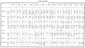
 |