THE steamer on Loch Maree affords a means of viewing the beauties of this
queen of Highland lochs in a thorough and luxurious way.
The route from the Gairloch Hotel past Loch Tollie to the junction with
the Tollie road is described in chap. vi. of this Part. Proceeding down
the estate road past Tollie farm, the tourist will be delighted with the
views of Loch Maree and Beinn Aridh Charr, and will soon arrive at Tollie
pier in the north-western corner of the loch, where trees and rocks mingle
in lovely confusion beneath rugged grey cliffs.

Loch Maree is a magnificent sheet of water, rather over twelve miles in
length. Pennant in his "Tour" (Appendix B) says it is eighteen miles long,
and this error has been repeated in the New Statistical Account (Appendix
E), and in most of the guide-books. The Old Statistical Account (Appendix
C) gave the correct length, which can now be attested by any one who will
take the trouble to refer to the Ordnance Survey.
Pennant described the scenery of the loch as "making a most beautiful
appearance." Dr Arthur Mitchell, adopting the opinion expressed in
Anderson's excellent guide, characterises the scenery as "utterly savage
and terrific," though he admits that the islands make the loch "an
exquisite picture of calm beauty."
Thus doctors disagree! without claiming to have anything new to say on the
question, I must express the opinion, which I share with many others, that
the scenery of Loch Maree is not surpassed in the United Kingdom for both
wild and gentle beauty.
Perhaps its leading characteristic is the frequent contrasts it exhibits
between barren, often precipitous, rocks and mountains on the one hand,
and calm lochs, smiling woods, or richly-coloured moors on the other. The
unconscious, or unanalysed, impressions of these contrasts produce the
most pleasing effects on the spectator's mind and feelings.
The Rev. Mr Small refers to the charms of contrast, exemplified in the
scenery of Loch Maree, thus :—
"In rugged grandeur by the placid lake,
Rise the bold mountain cliffs,
sublimely rude;
A pleasing contrast, each with each, they make,
And
when in such harmonious union viewed,
Each with more powerful charms
appears imbued.
Even thus it is, methinks, with mingling hearts,
Though different far in nature and in mood,
A blessed influence each to
each imparts,
Which softens and subdues, yet weakens not, nor thwarts."
The derivation of the name Maree from St Maelrubha is discussed and
conclusively established by Dr Mitchell (Part II., chap. xi.). Other
references to the loch incidentally occur in several parts of this book.
At Tollie pier (erected 1883) we step on board the little steamer, and
commence the tour of the loch. It will be more convenient to describe the
left or north-east shore on our way up the loch, and the other side on the
return .voyage. As the steamer leaves Tollie pier the Fox Point (Gallice",
Rudha mhadaidh ruaidh) is seen on the left. It is a low and small
promontory, terminating in grey-white rocks, deriving its name from some
story of a fox closely pursued by dogs taking to the water here, or from
some fox of unusual size being killed at the place.
Observe the extreme clearness of the water of Loch Maree. Owing to the
rocky and gravelly nature of the bed and shores of the loch, its waters
never acquire that dark peaty tinge which characterises the water of Loch
Katrine. The Fox Point has long been the resort of persons suffering from
various ailments, who have come to drink of the marvellously pure water of
the loch, which is, or was, believed to possess valuable health-restoring
qualities (Part II., chap. xiii.). The traveller casually tasting Loch
Maree water, especially in the summer when it is slightly warmed by the
sun, may be disappointed with its flavour, or rather want of flavour, and
may think it lacking in freshness. Remember that the fresh sparkle of much
spring water, so agreeable to the palate, is due to a certain amount of
mineral or other impurity.
Behind, or to the north of, the Fox Point the River Ewe leaves I^och Maree.
Here are Inveran House and Inveran farm (Miss Maclennan), situated on the
estate of Sir Kenneth S. Mackenzie, Bart, of Gairloch, to whom both sides
of the River Ewe and, as we shall see, most of the shores of Loch Maree
belong, as well as all its islands and the sole right to the salmon and
sea-trout fishings, not only of the loch but also of the river and
contiguous sea.
This end of Loch Maree has its Ossianic legend (Part I., chap. i.). " The
sweetheart's stepping-stones " are said to have been placed in their
present position in the water near the Fox Point by Fingal himself; they
render the navigation difficult to those ignorant of their localities.
From the Fox Point to a burn a mile further up, the estate of Mr Osgood H.
Mackenzie abuts on the loch; then commences the property of Mrs Liot
Bankes. The scrubby wood on the hill side sloping to the loch is called An
Fhridh dhorch, or " the dark forest." The sheep have been removed from
this ground, so the wood here
will now have a chance of growing. As the steamer emerges from the
comparatively narrow part of Loch Maree the new mansion-house of Ardlair
(Mrs Liot Bankes) comes in view, situated in natural pleasure grounds of
peculiar beauty. The charms of this place, embracing sloping lawns, shady
glades, dense thickets, graceful trees, masses of grey rock, and a shingly
beach, edged by a belt of feathery wood, the whole reposing at the foot of
magnificent precipices, seem to constitute a sort of garden of the
Hesperides, and fully justify the title bestowed on the spot by a Scotch
poet, who truly called it "the sweet Ardlair." The name Ardlair signifies
"the mare's height." It is derived from a stone, rather like a horse's
head, which stands in the loch a few yards to the south of the pier below
the house.
A little past the cultivated land, to the east of the house of Ardlair, is
the "Cave of the king's son" (Part I., chap, iv.); near it is the stone
still called the "Minister's stone" (see illustration, page 81), where
tradition has it that the Rev. Farquhar MacRae (Appendix A) used to
preach.
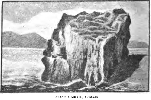
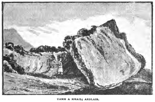
Beyond the woods of Ardlair may be seen a large boulder on the beach,
called Clach a Mhail, or "the stone of rent or tribute" (see
illustration), at which the proprietor of the Letterewe estate used to
gather his rents, and where a whisky market used to be held. A small cave
a little above, called Uamh a Mhail (see illustration), was used by the
proprietor if the weather were too stormy for his business to be conducted
at the stone. Further on is a long bluish-looking
point called Rudha Chailleach, or "the old woman's (or witch's) point,"
where it is supposed women accused of witchcraft used to be ducked, or
more probably drowned.
On the side of Beinn Aridh Charr, about half way up above Rudha Chailleach,
is a conspicuous mass of quartz, called the "White horse." Its shape
justifies the name.
Our notes on the islands, among which the steamer passes when opposite
Rudha Chailleach, shall be deferred until the return journey.
An enormous rock, or rather lump of rocks, on the southern shoulder of
Beinn Aridh Charr rises (just beyond Rudha Chailleach) to the height of
1000 feet. It consists of a number of large rounded masses of stone
descending sheer into the waters of the loch, and is called Craig Thairbh,
or the "Bull Rock," from a detached stone in the water at the base of the
rock supposed to resemble in shape a bull. After passing the Bull Rock the
shores of the loch are more or less wooded for a distance of some four or
five miles.
On a wooded knoll opposite Isle Maree is an artificial cave, called Uamh
an Oir, or "the cave of gold," about forty yards from the margin of the
loch. It is an old excavation, made by searchers for the precious metal,
which is said to have been found there but in unremunerative quantity. Dr
Cochran-Patrick, in his "Early Records relating to Mining in Scotland,"
gives many interesting facts on the subject of gold mining. Gilbert de
Moravia is said to have discovered gold at Durness in Sutherland in 1245.
The Scottish Parliament granted to the Crown in 1424 all the gold mines in
Scotland. Gold mines were commenced on Crawford Moor during the reign of
James IV., about 1511. During the minority of James VI. Cornelius de Vois,
a Dutchman, obtained in 1567 a license from the Regent Murray to work gold
and silver for nineteen years in any part of Scotland. Cornelius de Vois
had several partners who held shares in the adventure. The gold is said to
have been found by them principally in the glens and valleys. This "cave
of gold" may have been made by them. Many later attempts were made to find
gold as well as silver. There is nothing whatever to shew when the search
which resulted in the formation of the "cave of gold" took place.
According to the New Statistical Account (Appendix E), this excavation was
made by some one seeking a vein of silver, and several old people now
living say the same, but the name "cave of gold" seems to connect it with
the more precious metal.
A rounded mountain to the east of Beinn Aridh Charr, called Meall
Mheannidh, is seen above the craggy eminences of Letterewe; and just
beyond it Beinn Lair rises in a flattish undulating form, with one small
point shewing to the summit. This hill is as it were broken off towards
the north in a series of remarkably fine precipices, not discernible from
this side (see illustration, page 54). At the back of Beinn Lair are the
Claonadh, or "slopes," mentioned in the story of the "Gillie Buidhe" (Part
I., chap. xiv.).
The woods of Letterewe begin about half way up the loch. At the
commencement of the policies may be noticed the mouth of a canal, and, on
the hillside above, the track of a tramway in connection with it. These
were constructed by the late proprietor for the purpose of bringing
limestone from an extensive and picturesque quarry further up. The quarry
is now disused.
To the east of the tramway track notice a fine cascade. Letterewe House
(Mr C. Perkins) is an old mansion of the Mackenzies of Letterewe, and is
now the property of Mrs Liot Bankes, whose estate extends from the burn
(already mentioned) between the Fox Point and Ardlair up to another burn
on the west side of Slioch.
A mile beyond Letterewe House the Furnace burn falls into Loch Maree. The
hamlet of Furnace takes its name from the iron-smelting furnace (Part I.,
chap, xx.) established here by Sir George Hay in or about 1607.
The hamlets or places from Letterewe to the head of Loch Maree are in the
following order:—Furnace, Innis (or Inch) Ghlas, Coppachy, Regoilachy, and
Smiorsair. Above them rises the lordly height of Slioch,—not Beinn Slioch,
if you please,—whose name signifies a spear-head; the conical shape of the
mountain, as seen from Talladale and Slatadale, resembles the form of the
rather thick head of an ancient spear or lance, and still more closely
that of an ancient flint arrow-head.
Slioch loses this conical form as the steamer approaches, the mountain; it
now assumes the appearance of a vast wall, furrowed and grooved by the
natural agencies of ten thousand- generations. The rills and burns which
trickle down its steep sides become in wet weather foaming cataracts. The
upper part of the mountain is fluted by deep weather-worn channels, thus
forming the range of grand summits that nobly cap this chief feature of
Loch Maree. Whilst Beinn Aridh Charr is remarkable for its graceful
contour, Slioch stands pre-eminent for its barren wildness and grandeur.
At the foot of the Fasagh burn, which flows into Loch Maree to the east of
Slioch, afe, on the one side (at some little distance), the old
burial-ground called the Cladh nan Sasunnach, or "English graveyard "
(Part I., chap, xviii.); and, on the other (the east side of the burn),
the remains of ancient ironworks, where large quantities of slag may still
be seen (Part I., chap. xx.).
From the head of the loch, which the steamer is now nearing, stretches
away to the south-east the partly cultivated strath of Ken-lochewe, with
the farm of Tagan in the foreground. On the left of the strath, towards
the north-east, is a spur of Beinn a Mhuinidh, called the Bonaid Donn,
with its waterfall, which, during or immediately after heavy rains, is a
fine cascade of the mare's-tail type (Part III., chap. L). On the
south-west side of the strath is Meall a Ghuibhais; and exactly below it,
near the head of the loch, the steamer pulls up at the pier on a shingly
beach—a "silver strand"—which forms the promontory generally known as Ru
Nohar, or " the giant's point." The full spelling of the Gaelic name is "Rudha
an Fhomhair" (see "Glossary"). The name of the giant after whom this point
is called is not recorded. Can he and his fellows have been buried in the
large graves in the Cladh nan Sasunnach?
After a ramble on shore, where many a pleasant nook amid woods and rocks
may be found by the roadside suitable for a brief pic-nic (including the
consumption of the lunch which the thoughtful voyageur will have provided
before starting), we again embark on the steamer for
The Return Voyage.
Our notes will now describe the right or south-west side of the loch, and
also the islands which add so much to the beauty and romance of Loch Maree.
Observe, as the Mabel gets under way, the slopes and under-•cliffs of
Meall a Ghuibhais, clothed with extremely beautiful woods. They consist
for the most part of birch and pine raised by nature, and therefore more
picturesque than if planted by man. The oak, the ash, the rowan, the
sallow, the hazel, and the quivering aspen, are mingled with the firs and
birches, and are all indigenous. Black game and roe-deer abound in these
woods, and may often be observed near the margin of the loch. Above the
woods are rocky heights : in one place a yellow scar is noticeable, where
a landslip occurred many years ago, illustrating the effect of water and
frost in disintegrating the hardest rocks.
The woods of Glas Leitire, as this fragment of the old forest is named,
extend along some two miles of our return route. As they become thinner,
individual trees display their characteristic shapes more freely (see Her
Majesty Queen Victoria's remark about these trees quoted in Part IV.,
chap. iv.).
The county road towards Gairloch, also described in that chapter? runs
along the side of the loch we are now noticing. It may be seen here and
there winding through the trees, or surmounting some rocky point'on the
edge of the loch.
After passing the Glas Leitire woods, Glen Grudidh opens out : the
transition from the lovely woods to this wild lonely glen is indeed a
transformation scene ! The view looking up Glen Grudidh is one of the
finest in the country; the herbage assumes, particularly in autumn, a
ruddy golden hue, contrasting wonderfully with the blue-grey boulders
scattered upon it, and the steep blue peak of Ruadh Stac—the highest
summit in Gairloch parish—and of Liathgach which form the background.
Further on, at a distance of five miles from the head of the loch, is
Grudidh Island (Eilean Grudidh), in a small bay renowned for its sea-trout
fishing, and where now and then a salmon is hooked. This interesting
little island (Part I., chap, xxi.) was originally a stronghold of the
MacBeaths, and was afterwards held by the Macleods (Part I., chap. xii.).
Rounding a promontory, called Aird na h' Eigheamh, or "the calling point,"
which considerably narrows the loch, we come in sight of the main body of
the islands. They are said to be twenty-four in number, but no one can
accurately number them. When the loch is high from recent rains many parts
become detached from the larger islands, which when it lowers again are
reunited. The principal islands are Isle Maree, Eilean Suthainn (" the
everlasting island"), Eilean Dubh na Sroine ("the black isle of the nose
or promontory"), Garbh Eilean ("the rough isle"), and Eilean Ruaridh Mor("the
big island of Rory "), with its pendicle Eilean Ruaridh Beag. Another
considerable island is called " the planted island." These islands are
part of the Gairloch estate of Sir Kenneth Mackenzie; they are the resort
of red deer, which swim across from the mainland; and of black game,
sea-gulls, and wild fowl, as well as occasionally of roe-deer. In a hard
winter wild swans repair to Loch Maree (which is never frozen over), and
frequent the islands. A specimen may be seen in the Loch Maree Hotel. Wild
geese (the grey lag goose), wild ducks, mergansers, goosanders,
black-throated divers, and countless sea-gulls, visit the islands during
May and the following months for the purpose of nesting and rearing their
young. The sea-gulls are of four kinds, viz., the great black-backed gull
(two or three pairs), the lesser black-backed gull (in great numbers), the
herring gull (very few), and the common or winter gull (a few pairs).
The islands are for the most part beautifully wooded,—some of the trees
being the remains of the ancient forest, which their insular position
protected from the axe of the ironworkers ; others self-sown in recent
years; and others again planted by the lairds of Gairloch, to whom all the
islands have for four centuries belonged. It is pleasant to notice young
trees springing up along the north-east shore of the loch, no doubt the
result of seed blown from the islands.
Isle Maree is the best known and most interesting of the islands (Part I.,
chap. ii.; and Part II., chaps, xi. and xii.).
The following verses by Mr James G. Whittier, the American poet, though
not quite exact in descriptive details, refer so touchingly to the holy
well of Isle Maree (see page 151 et seq.) that I must quote them here :—
"Calm on the breast of Loch Maree
A little isle reposes;
A shadow
woven of the oak
And willow o'er it closes.
Within a Druid's mound is seen,
Set round with stony warders,
A
fountain, gushing through the turf,
Flows o'er its grassy borders.
And whoso bathes therein his brow,
With care or madness burning,
Feels once again his healthful thought
And sense of peace returning.
O restless heart and fevered brain,
Unquiet and unstable,
That holy
well of Loch Maree
Is more than idle fable!
Life's changes vex, its discords stun,
Its glaring sunshine blindeth,
And blest is he who on his way
That fount of healing fmdeth!
The shadows of a humbled will
And contrite heart are o'er it;
Go
read its legend—'Trust in God'—
On Faith's white stones before it."
Eilean Suthainn is the largest of the islands. It is nearly a mile long.
Within it is a small loch, with two small islands, on one of which is a
large fir tree. Beneath this tree the fairies used to assemble (Part II.,
chap, xiii.), and in its branches an osprey used to build its nest.
Another osprey built on a headland of this island (Part III., chap. vi.).
There are traces of the remains of the residence of Alastair Breac, laird
of Gairloch, and of some of the older chiefs of the Mackenzies, on this
island, as well as of bothies where illicit distillation used to be
carried on.
Eilean Ruaridh Mor is called after a celebrated chief of the Macleods. On
this island, as well as on Garbh Eilean and Eilean Suthainn, the illicit
distillation of whisky was extensively conducted in th^ early part of the
nineteenth century.
To the west of Eilean Ruaridh Mor is the small island known as Eilean
Ruaridh Beag (or "the little island of Rorie"), formerly the residence of
Ruaridh M'Leod, and subsequently of John Roy Mackenzie (Part I., chap.
xxi.).
The steamer passes between Eilean Suthainn and the mainland to the south
of it, and soon reaches the Loch Maree Hotel (described in chap. iv. of
this Part).
There is a fine view from the steamer, looking up the glen down which the
Talladale river flows. To the right is the eastern shoulder of Beinn an
Eoin. The mountain further back, and some distance to the right, is
Bathais (or Bus) Bheinn. It is better seen from further down the loch.
After a brief call at Talladale the steamer proceeds in a northerly
direction. For a mile or so the Talladale woods continue alongside, and
then comes the Garavaig water, where the Slatadale farm begins. About
three hundred yards from the loch may be seen through the trees the
Victoria Falls (Part III., chap. i.). Close to the loch, at this point,
are remains of iron-smelting (Part I., chap. xx.).
The Slatadale farm-buildings are a quarter of a mile further on. Above
this farm the road to Gairloch is seen climbing the hill, but taking
advantage of a depression.
The steamer now passes between Garbh Eilean, on the right, and Eilean
Ruaridh Mor, on the left. Notice the fine views of Slioch.
Beyond Slatadale, i.e. to the west and north-west of the Mabeh course, not
a dwelling of man is to be seen, except a shepherd's cottage (now
uninhabited) at a place called Doire. The old road, which was formerly the
main road to Poolewe, may be traced here and there, until it disappears
behind the range of Craig Tollie.
A large bay now opens out, with a small wooded island; it is called Ob
Choir T, i.e. "the bay of the island corrie." This name is Anglicised into
the "bay of Corree." Here, in the summer of 1868, I was fishing with a
friend, who succeeded, after a struggle extending to forty minutes, in
landing a magnificent yellow trout of twenty-one lbs. (Part IV., chap.
xvii.).
Leaving Corree bay well to the left, we reach the point called Rudha aird
an anail, or "the high point of breathing," this being a favourite spot
for a few minutes' breathing-time when rowing up or down the loch. Observe
how the rocks are rounded by ancient glacial action.
From this point the first spur of the range of rocky hills called Craig
Tollie begins to rise. A quarter of a mile further on is a rugged cliff,
with a precipitous face, 300 feet high, which descends sheer into the loch
(here thirty fathoms deep), and is often called the "Black Rock," from its
generally dark colour. The peregrine falcon builds her nest on a tiny
ledge of this cliff, on which the young falcons are reared, unless the
wary keeper shoots or traps the old birds; or else, let down by a rope
fastened round his armpits, robs the nest of eggs or young, as I have
witnessed.
On the Black Rock it is said there was formerly an eyrie of the golden
eagle, until the ledge where the nest used to be built was destroyed or
detached by a flash of lightning.
.In the face of the Black Rock, on the northern end, is a cave, hidden by
a mass of ivy, about twenty yards above the water, and almost
inaccessible. The hardy and sure-footed Highlander, John Mackenzie,—who
was the last post-runner from Dingwall to Gairloch, and was called Iain
Mor am Post (Part II., chap, x.),—succeeded in entering this cave, and
reported that twelve men might sit in it. The cave is called in Gaelic
Uamh gu do roghiann, or "the cave for your choice," a name supposed to
refer to some love story now forgotten.
The steamer proceeds alongside the slopes and below the crags of Tollie.
The highest point of this range is 1123 feet in height. Some forty years
ago a sad event occurred on the side of Craig Tollie. Heather burning,
which is carried on in the months of March and April every year, in the
interests alike of grouse and sheep, was in hand, and a newly engaged
fox-hunter or trapper was assisting. Smothered by the smoke and overtaken
by a sudden rush of flame, he was burned to death. Grand effects, as if
blazing lava were pouring down the hillsides, are often witnessed during
the annual seasons of heather-burning.
Stepping on to Tollie pier, we have completed the tour of Loch Maree, and
again enter the carriage or "machine," which returns to Gairloch by the
way we came.

