|
By LIONEL W. HINXMAN, H.M. Geological Survey.
THERE is perhaps no more striking group of mountains
in the British Islands than those strange isolated masses of red sandstone
which rise like huge monoliths from the tumbled grey sea of primitive gneiss
along the western seaboard of Sutherland and Ross-shire.
They have been graphically described by Macculloch,
who, writing at a time when the beauties of Highland scenery were yet
undiscovered, characterises them in the following words:—" Round about there
are four mountains, which seem as if they had tumbled from the clouds,
having nothing to do with the country or each other, either in shape,
material, position, or character, and which look very much as if they were
wondering how they got there. Which of them all is the most rocky and
useless, is probably known to the sheep; human organs distinguish little but
stone,—black precipices when the storm and the rain are drifting by, and
when the sun shines, cold, bright summits that seem to rival the snow." Hugh
Miller, who was perhaps the first to perceive the unique character of these
mountains from a scenic point of view, has drawn their picture with a pencil
dipped in glowing colours, and invested them with a singular and poetic
charm; while his description has been equalled, if not surpassed, by Dr A.
Geikie, in his "Scenery of Scotland."
Rising directly from the gneiss plateau, which, though
carved into innumerable glens, hollows, and ridges, yet preserves in its
eminences a tolerably uniform level, these heights possess more of the true
mountain form than most of our Scottish hills, where the eye is gradually
led up from spur to spur to the culminating peak, which often rises little
above the surrounding ridges. Here, however, the whole mass and height of
each mountain is taken in at a glance; while their strange isolation, and
incongruity, both in form and colouring, with their surroundings, give to
these peaks a fascination and impressiveness which we look for in vain
amongst such mountain masses as those of the Cairngorm range.
It is hard to decide to which of the group the
superiority should be given. Quinag, with its mile-long wall of precipice
fronting the western sea, and the magnificent bastions of Sail Garbh; the
twin peaks of Coul Mbr, one keeping guard over the depths of the Corrie Dubh,
the other frowning above those mighty terraces which fall, in steps of a
thousand feet, down to the wild loneliness of Gleann na Laoigh; the towering
cone of Coul Beag; the fantastic pinnacles of Stack Polly; the long serrated
ridge of Ben More Coigach,—have all their particular charm.
Suilven, however, though yielding in height to most of
his neighbours, yet combines more of the characteristics of a true mountain
than can perhaps be found in any one of them. Few mountains, too, present a
greater diversity of aspect. The long knife-edged crest, deeply cloven in
three by narrow couloirs, that rises above the lonely shores of Loch
Veyattie; the double peak that starts up against the horizon, and arrests
the attention as one approaches Alltnagealgach from the east; or, most
striking of all, the wonderfully symmetrical cone that looks out over Loch
Inver and the sea; in days of storm, when the black peak looms for a moment
through the flying cloud-wrack, and the ragged mist swirls round the crags;
or flaming up in the long afterglow of summer evenings, a pyramid of fire
against the soft pale green of the eastern sky,—from every point of view,
and under every condition, Suilven will always hold his place as unique
amongst the mountains of the west.
Suilven lies in the heart, and is indeed the
sanctuary, of the deer forest of Glen Canisp, from which, at the time of our
ascent, both tourists and geologists were rigorously excluded, for the then
lessee was of the opinion that the latter at least were "of no use but to
frighten the deer and upset the Bible."
From the position and comparative inaccessibility of
the mountain the ascent is not often made, and during the two previous
summers, spent in surveying the surrounding country, I had cast many longing
looks towards the formidable eastern peak, said to be very difficult to any
one but an expert climber. It was not, however, till our third summer in
these regions that we began to realise that our campaign in Assynt was
drawing to a close, while Suilven still remained unconquered.
We were then staying at the farmhouse of Achumore,
which lies about two miles west of Inchnadamph, delightfully situated among
the green flower-covered knolls and hollows of the limestone plateau that
slopes up in alternate grassy lawn and miniature escarpment from the
northern shore of Loch Assynt to the grey stony flanks of Glasven and Ben
Uidhe. Past the farmhouse flows a burn of the purest water, which has its
source in two powerful springs at the foot of Glasven, and is, even at its
birth, a stream of considerable volume. These springs, supplied from the
subterranean chambers of the limestone, seem almost unaffected by ordinary
rain or drought; and the burn flows, in a perennially clear and full stream,
through the grassy meadows of Achumore, gay in summer with purple orchis and
yellow globe-flower, and, dashing over each successive escarpment in a
series of miniature waterfalls, mingles with the waters of Loch Assynt in
Ardvreck Bay, beneath the shadow of the old castle.
It was from these pleasant quarters that I, with my
friends H- and C--, started, on a lovely morning in early June, for the long
contemplated climb over the ridge of Suilven. We had determined to drive as
far as Loch Awe, which lies about six miles eastwards of Inchnadamph, on the
road to Lairg, and is the nearest point on any accessible road to the
eastern end of the mountain.
Ardvreck Castle, the ruined house of Calda, and the
comfortable hostelry of Inchnadamph—well known to every angler who has
visited that paradise of the trout- fisher, Western Sutherland—were soon
passed; and as we bowled along the smooth road beneath the grey cliffs of
Stronchrubie, where the goats were picking their way along invisible ledges,
the crisp morning air, filled with the music of bird voices,—the cheery crow
of the grouse cock, the wild cry of the peregrine wheeling about the crags
overhead, the whistle of curlew and greenshank along the river
flats—produced in one that indescribable feeling of enthusiasm with which
one starts for a mountain expedition in the Highlands. An hour's drive
brought us to the shores of Loch Awe, where the trout were rising merrily
along the edge of the reed-beds, dimpling the glassy surface, in which each
little wooded islet lay reflected as in a mirror.
Here we left our vehicle, and, crossing the Loanan
burn at the point where it issues from the loch, began the ascent of the
long quartzite slope, thickly strewn with boulders and moraine d/bris, which
forms the eastern spur of Canisp. A rough and tedious climb of about two
miles brought us to the crest of this subsidiary ridge, and, calling a halt,
we sat down to enjoy a rest and a pipe before descending into the deep glen
that lay between us and our goal. At our feet the ground fell in an abrupt
escarpment to the plateau from which rises the long, steep, southern face of
Canisp, stretching away on our right; its talus slopes, red with debris
fallen from the porphyry precipices, which girdle it with successive lines
of battlemented crag that are relieved here and there by greener spots where
the alternating slopes of more yielding sandstone are covered by a scanty
herbage.
Away on our left, beyond the long trench-like loch—
Loch Fada—which fills the narrow glen beneath, we could catch the glitter of
the sunlight on the bays of Cama Loch and see, rising beyond, the green
knolls and white houses of Elphin; while farther still in the distance
stretched the smooth heather-covered slopes of the Cromalt Hills. Right in
front, on the farther side of the glen, rose the great northern wall of
Suilven; and as we looked at that seamed and rugged precipice, we realised
that a stiff task lay before us. No time was to be lost, however, so
knocking out our pipes, we scrambled down the steep descent to the plateau
below, and keeping for a mile or so along the top of the cliffs that rise
from the northern shore of Loch Fada, finally descended into the gloomy
depths of Glen Dorcha (the glen of darkness), and crossed the stream that
connects Loch Fada with Loch Ganimhich. The south side of the glen is here
very steep, and overgrown with long heather, than which there is nothing
more trying to climb through, one's boots slipping on the stems when
inclined downwards in a peculiarly aggravating manner. However, the top was
reached at last, and a tramp of nearly two miles over well-polished knolls
of grey gneiss, interspersed with peaty flats and small shallow lochans,
brought us to the foot of the eastern peak, where the real work of the day
was to begin.
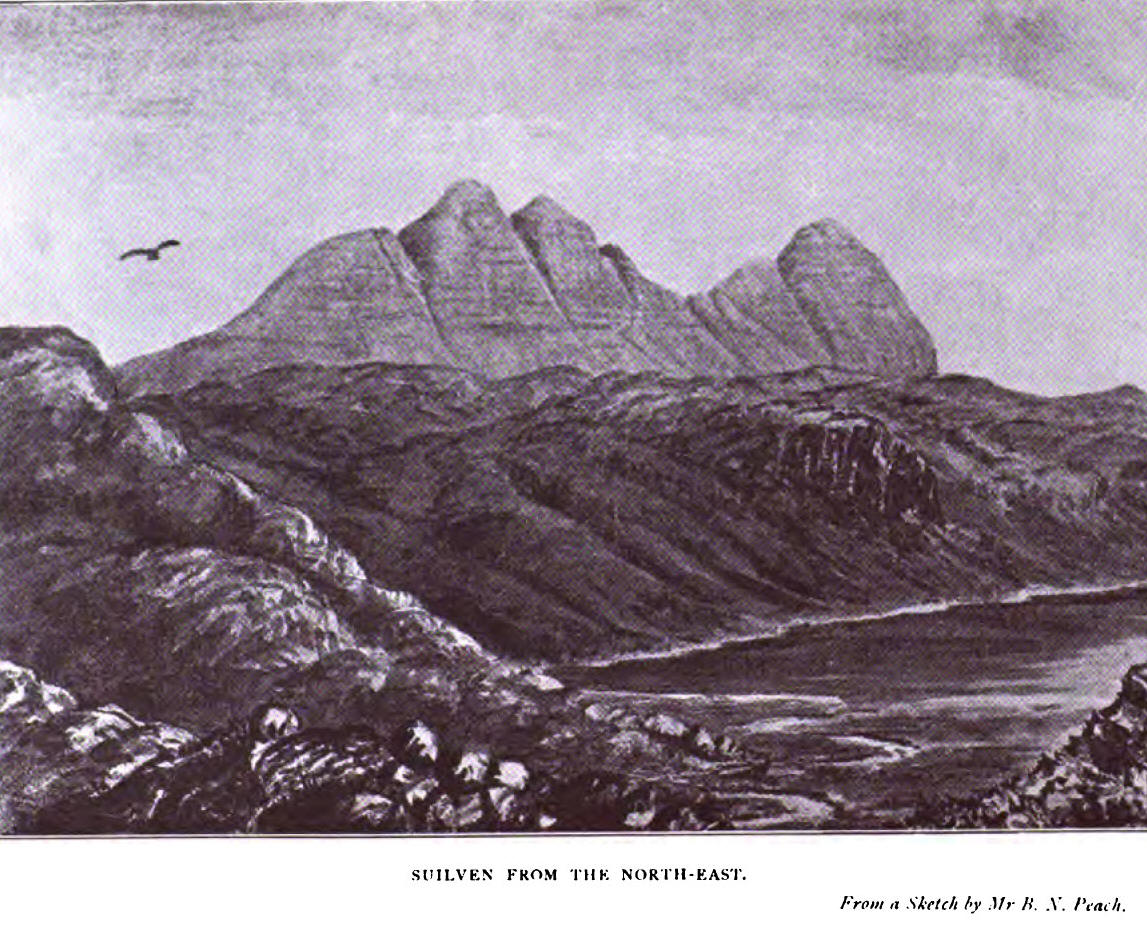
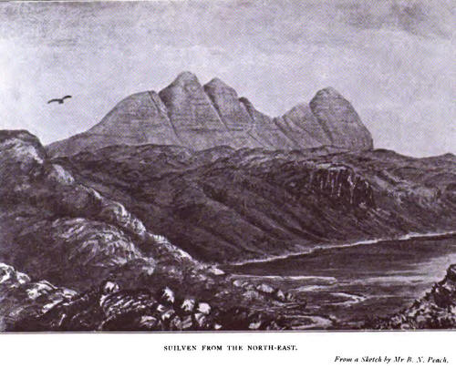
For the benefit of those who are unacquainted with
Suilven, a brief description of the form of the mountain may here be given.
Rising steeply from a comparatively even base, it
sweeps up rapidly in successive ledge and precipice, presenting an almost
unbroken wall of rock save where the mountain torrents have cut deep gashes
down its sides. In fact, looking at the mountain from a little distance
either on the north or south, it appears as if these formidable-looking
con/airs were the only possible means by which the top could be reached. The
crest of the mountain forms a ridge about a mile and a half in length,
divided by deeply- cut clefts into three peaks of unequal height. These are
known respectively as Meall Bheag (little hill), Meall Mheadhonach (middle
bill), and Caisteal Liath (the grey castle). The latter forms the western
extremity of the ridge, overlooking Loch Inver, and is the highest of the
three, the Ordnance cairn giving the summit as 2399 feet above sea-level.
Meall Mheadhonach is about ioo feet lower, while Meall Bheag barely reaches
2000 feet.
The clefts—to which the striking appearance of the
mountain, when seen in flank, is chiefly due—mark the position of two faults
which cut through the ridge from north to south, letting down the sandstone
strata in each instance to the west, though the forces of denudation have
long since obliterated all difference of level at the summit, which at
the,present time is in each case actually lower on the upthrow, or unmoved
side, of the line of fracture. A probable explanation of this fact may be
found by supposing that a band of harder rock was successively let down a
step, and thus the wasting and wearing down process went on more rapidly in
the softer strata on the upper or eastern side of each line of fault. The
natural drainage of the hill, taking advantage of the course of these
faults, has cut deep gullies filled with loose debris down the talus slopes.
This debris is inclined at so steep an angle, that a touch of the foot is
often sufficient to set the whole mass in motion. Where, however, the lines
of fracture cross the ridge, one side of each cleft forms a more or less
perpendicular wall of rock, the other a steep broken slope; and it is in
crossing these nicks that the only real difficulty of the climb is found.
The mountain is composed throughout of red gritty
sandstone, which generally gives good foothold, and, though apt to crumble
in places, is never slippery. The sandstone lies in almost horizontal beds
of nearly uniform thickness, which can be traced, like lines of masonry,
along the sides of the hill, and are carved along the wind-swept crest into
a thousand forms of bastion, turret, and pinnacle, thus giving that
architectural appearance which is so characteristic of these sandstone
mountains.
The western peak is symmetrically dome-shaped, and
plunges down at its farther extremity in an almost perpendicular precipice
to the talus slope, which sweeps out, in bold parabolic curves, from the
foot of the cliff to the gneiss plateau below.
Meall Bheag, though formidable enough, is less
precipitous on its outer side, and, rising from a considerably higher level
to a considerably lesser attitude, cannot compare in grandeur with the great
mural precipieces of Caisteal Liath.
To reach the top of Meall Bheag was now our aim, and,
after reconnoitring it on all sides, we determined to attack the peak at the
south-east corner, where the first slopes seemed less steep than elsewhere.
A tolerably easy scramble up the grassy incline,
strewn with fallen blocks of sandstone of all sizes, brought us to the foot
of the escarpment, where the real climb might be said to begin. Precipitous
though this part of the hill appears when seen from a distance, it is yet so
broken into ledge and terrace by the unequal weathering of the sandstone
courses, that to a firm foot and steady eye it presents no greater
difficulty than that involved in going up a somewhat steep and irregular
staircase, with steps varying from one to three feet in height.
Occasionally, however, a higher step of six feet or more blocked the way,
and had to be followed along until a break, or a succession of convenient
crevices, was found, by which it could be surmounted. In this way, by a
system of judicious zig-zagging, we soon reached the top, which forms a
nearly fiat plateau, covered with scanty grass and loose sandy debris.
Crossing to the western end, where it overlooks the
cleft between Meall Bheag and Meall Mheadhonach, we became aware that
between us and our next goal there was indeed a great gulf fixed. The cliff
on the east side of this gully is not only vertical, but actually overhangs,
as can be distinctly seen from any point on the south side of the mountain ;
and to get down on to the narrow saddle that bridges the chasm between the
two peaks seemed at first an impossibility.
Of course we could have solved the problem by going
down again to the foot of Meall Bheag, and ascending Meal! Mheadhonach by
means of the dividing cleft. But this was an ignominious way out of the
difficulty not to be entertained for a moment. We had come out to climb
Suilven from end to end, and climb him we would.
So, after craning over the horrid gulf for some little
time, and examining the rocks on all sides, we came to the conclusion that
nothing but a goat could get down there, and that the position must be
turned in flank, or not at all.
Crossing over, then, to the northern side of the peak,
we let ourselves cautiously over the edge of the cliff, gradually worming
our way down from ledge to ledge wherever a good opportunity for-a drop
occurred, but always working westwards towards the cleft, until we found
ourselves almost immediately underneath the overhanging rock from which we
had just before looked down. This was a bit of work requiring great caution
and a steady head, for at nearly every point the cliff fell sheer down to a
depth of several hundred feet, and a slip at any time would have been fatal.
Otherwise the foothold was good, and the ledges always sufficiently broad to
enable one to move along with comparative safety, though here and there we
had to crawl on hands and knees, the shelf above projecting too far to allow
of walking upright. However, all went well, and, one after another, we crept
round the last corner, and established ourselves on the narrow rock of
porphyry which connects the two peaks.
Looking down the tremendous gash, through which the
wind was sweeping with fearful force, we saw the distant landscape set, as
it were, in a narrow frame of perpendicular walls that plunged down on
either side. The entire absence of middle distance, and the immense extent
of atmosphere through which one looked to the country beneath, gave a very
curious and striking character to this mountain picture, enhanced by the
startling contrast between the dark walls of the cleft and the sunny
landscape far below.
In spite, however, of the wonderful view, this was too
draughty a spot in which to linger, and we were soon attacking the farther
side of the chasm.
The first few feet surmounted, leading from the neck
to the slope above, the rest was not difficult, this side of Meall
Mheadhonach sloping at an easy angle compared with the face that we had just
come down. A climb of about 400 feet brought us to the crest of the middle
peak, which forms a narrow ridge, in places less than a yard in width, and
falling abruptly on either hand to the edge of the cliffs that flank each
side of the mountain. So narrow was the path, and so furious the wind that
swept across it, that we found it advisable to descend a little on the
leeward side, and thus escape the fierce gusts that threatened at times to
sweep us off our feet.
At the highest point of the ridge there is a
shepherd's cairn, and round this were scattered many eagles' casts,- oval
concretions of wool, hair, and feathers mixed with fragments of bone, which
the eagle, like ail birds of prey, throws up, after assimilating the more
digestible parts of its food. We also found a few feathers, which we carried
off as trophies, though we were not fortunate enough to see any of the
birds, a pair of whom at that time had their eyrie in a high rock in the
glen below. Golden eagles are still tolerably plentiful in this part of
Sutherland, and being preserved are believed to be increasing in numbers. My
friend P—, who a few days before our expedition had observed the birds leave
the eyrie, has seen as many as four eagles, probably a pair with their
young, hunting together in Glen Canisp; and I have watched them sailing in
lazy circles for hours together round the topmost point of Quinag.
The sea eagle is now much more rare, but a pair used
to build regularly on the cliffs near Cape Wrath, and another near the
Whitten Head.
At the western end of the ridge we came to another
rather nasty bit,—a drop over several feet of perpendicular rock on to the
slope that leads down to the Bealach Mor, as the col between Meall
Mheadhonach and Caisteal Liath is called. This however, I believe, might
have been avoided by going a little farther down the ridge on the south
side, and working round the corner as we had previously done on Meall Bheag.
The rest of the descent to the Bealach was easy
enough, and, having reached the ruined wall that here crosses the ridge,—put
up at the time when Glen Canisp was a sheep farm to prevent the sheep from
straying on to the dangerous parts of the mountain, -we called a welcome
halt for luncheon.
Half-an-hour sufficed for this and the necessary pipe,
and climbing leisurely up the slope at the western end of the col, we were
soon standing on the dome-shaped eminence that crowns the great cone of
Caisteal Liath.
Here, for the first time, we stopped to take a long
look at the magnificent prospect that lay before us. Beneath our feet, as we
looked out to the west, lay the houses of Lochinver, fringing the sheltered
bay, beyond which the wide Atlantic stretched away to where the long blue
line of the Outer Hebrides lay like a cloud along the western horizon.
On the north, the long wall of Canisp cut off much of
the view, but we could see on the left the great precipices of Quinag, and
the wide rolling expanse of hill and valley, studded with innumerable
lochans, which stretches away from the northern shores of Loch Assynt to the
low bare promontories of Stoer and Ardvar.
To the east, the sharp peak and great corrie of Ben
Dearg showed above the smooth contours of the Cromalt Hills; and farther
away, against the south-eastern horizon, rose the beautiful cones of An
Teallach in Dundonnel, the highest of the sandstone mountains.
Turning to the south, we looked across the lonely
waters of Loch Veyattie straight into the profound depths of Corrie Dubh,
that magnificent amphitheatre carved out of the northern face of Coul Môr.
Beyond the narrow winding shores of the Fionn Loch, and the line which
marked the deep valley of the Kirkaig, lay the broad expanse of Loch
Skinaskink,* dotted with wooded islets, and backed by the graceful cone of
Coul Beag and the splintered spires and pinnacles of Stack Polly. Behind
them rose the long ridges and needle-like peaks of Ben More Coigach and the
Fiddler; while far away to the south-west stretched the Rhu Coigach and the
scattered archipelago of the Summer Isles.
The atmosphere was not clear enough for a very distant
view, but beyond the faint line that showed where the Cailleach Head and
Greenstone Point stretched into the Atlantic, we could just catch the dim
outlines of the hills of Gairloch and Loch Maree.
But we had now to think about turning homewards; and
while C- sat down to make a sketch, H- and I went to prospect the farther
end of the peak, fired with the wild idea of climbing down the western face,
and thus really traversing the mountain from end to end. But after
scrambling down for some distance, we found ourselves brought up suddenly by
a sheer wall of rock plunging straight down for several hundred feet, which
effectually put an end to our hopes in that direction. So rejoining C-.----
on the top, we determined to take the first practicable gully on the north
side, and trust to chance that it would lead us to the foot of the hill.
Down we went, the loose debris clattering and sliding
under our feet, and in a very short space of time—by dint of glissading with
the stones, when practicable, and clinging to the rocky side of the cleft at
the steepest parts—found ourselves within twenty feet or so of the foot of
the cliff. Here our progress was barred by a miniature waterfall, trickling
over the nearly vertical rocks, green and shiny with moss and liverworts,
and making a very unpleasant, if not impossible, place to get down. However,
retracing our steps for a little way, we found a branch gully, which
afforded an easy path down to the foot of the precipice.
Our hard work was now over, and, rattling down the
talus slope, a rough walk of half-an-hour brought us to Glen Canisp, and
crossing the stream just above Loch-analitain Duich, we struck the forest
path at Suileag.
From this point we had a good road under our feet, and
the three miles over An Leathad to the Inver were soon accomplished.
Crossing the river at Little Assynt, we found our trap awaiting us at the
shepherd's house, whence a drive of nine miles along the shores of Loch
Assynt brought us back to Achumore about eight P.M., in good time for a very
acceptable and well-earned dinner. The distances traversed are roughly as
follows:
Inchnadamph to Loch Awe, 4 miles; Loch Awe to foot of
Meal! Bheag, 6 miles; along ridge to west end of Caisteal Liath, 1½ mile;
from foot of Caisteal Liath to road at Little Assynt, about 5½ miles; Little
Assynt to Inchnadamph, 10 miles—Total, 27 miles, of which 14 can be driven.
Suilven can also be reached very easily from Lochinver,
the route taken being by Glen Canisp Lodge and the forest path to Suileag.
There is no difficulty whatever in reaching the top of Caisteal Liath (the
western peak) by going up the Bealach Môr, either from the north or south
side, and it is only in crossing the gap between the eastern and middle
peaks that any real difficulty or danger is to be found.
|