|
Pre-Historic
Dunfermline
Preliminary Notes
Previous to the middle of the eleventh century, the
historical accounts of Scotland abound with superstition, tradition, and
fable. This, along with the obscure notices given of localities, towns,
&c., makes it difficult, often impossible, to discover the places, or the
sites of the places referred to. The locality, now known as the "Western
District of the County of Fife," is no exception to this general rule of
pre-historic literature. But there can be no doubt that this locality,
long before, and after the time of Malcolm III. (Canmore) abounded in
"forests, moors, morasses, swamps, lakes, and rivulets," over which
"roamed the wolf, the deer, the bison, and the boar." Here and there might
be seen clay and turf huts, hovels and pit-dwellings, dignified with the
name of tun (town), the residence of the great men of the land, and
of the "squalid boors" their servi, or slaves, who were little
better than barbarians; "hoards of them were to be seen unclothed,
tattooed, painted, and adorned." These were the days
"When wild in woods the
noble savage ran."
During the period of "the Roman
occupation" (A.D. 83-440) our
locality, like other districts, was ruled and defended by tribes of
Caledonians, Picts, Scots, &c., "who with considerable ‘savage address’
frequently faced the Roman legions, and did havoc amongst them." For
upwards of 350 years the locality on which Dunfermline now stands, ever
and anon "resounded to
the
tramp and tread of Roman cohorts and
legions." These civilised warriors had
several stations, or strongholds, in the locality e.g., the hill, or
rising-ground, at Pratehouse, three miles east of Dunfermline, is the
supposed site of a Roman Praetorium. "The Praetor Hill," is the
designation in old writings, and is that adopted by the surveyors of the
late Government maps. Prate-House
is therefore a corruption of Praetor House, or residence, of the
chief of the Roman forces. About six miles N.E. by N. of Praetor Hill, is
Lochore, the site of a large Roman camp. About the same distance W.N.W.
from the hill are the sites of the camps of Carnock. These large
camps were connected with lesser strengths on convenient sites.
NOMENCLATURE OF THE DISTRICT
In consequence of the unsettled
occupation of the Romans in this district, few of the names they gave to
places now survive; but the names bestowed on places by the early
inhabitants are still to be found in whole, or in a mutilated
condition,—e.g., Bal, a dwelling, viz., Balmule, Balyeomen,
Balclune, Balrick (Baldridge), &c. In places prefixed by
Caer (the Castle) there are Carnock (Caer-knoc), Carneil,
Carniehill, Cairncubie, &c. Keir is from the same
root apparently as Caer,
and in Keirsbeath we have Castlebeath. There are still a great many
places remaining in the district prefixed by the Celto-British word Pit
a word of doubtful origin, viz., Pitencrieff, Pitfirrane,
Pitliver, Pitscotie, Pitdinnie, Pitconochy,
Pitathrie, Pitcorthie, Pitbauchly, Pitreavy. And,
lastly, with the Celtic prefix Dun, which signifies a hill,
or, more properly, a fortified hill, there are Dunfermline,
Dunduff, Dungloe, Dunibristle, Dunearn,
&c. (Vide works on Etymology for further information on such
nomenclature.) It may be remarked, "Mons infirmorum" is a designation
given to Dunfermline in the "Suspected
Foundation Charter" of the Abbey. If the charter, though perhaps
"garbled," is taken as a genuine document, then "Mons infirmorum" may have
been the original name of Dunfermline from the time of the Roman
occupation down to the time of Malcolm III.
There still remains a name of
doubtful origin, viz., "Fothriff" sometimes spelt "Fothric," "Fothrick,"
"Fatrick," &c. This name covered a very large extent of country,
stretching from the mouth of the Leven to some miles above Alloa in
length, and from the Forth to the base of the Ochils in breadth, thus
comprehending within its area the greater part of the counties of Kinross
and Clackmannan, and the whole of what is now known as the "Western
District of Fife." (For etymology, &c., see local histories of Dunfermline
and of Fife; also Appendix to "Annals of Dunfermline.") This
territory, or a certain division of it, was bestowed on the Church of the
Holy Trinity (the Abbey), at the time of its erection
(circa, 1070-1080). In some old works, Dunfermline
Abbey is represented as standing in Fatrick Muir. In conclusion,
the
FORTH, about the beginning of
the Christian era, and for a great length of time afterwards, appears to
have been known as the "Sea of Bodotria", which name was succeeded
by that of "Scot-water," and afterwards by
"Phorth," "Firth of Forth,"
&c., which last appellation it has
retained for at least these 900 years past.
DUNFERMLINE TOWER, THE RESIDENCE OF
MALCOLM III.
There is not the slightest notice of
this Tower, or of Dunfermline, until about
A.D. 1069-70, on the occasion of Malcolm’s
nuptials. After this important announcement, neither history nor tradition
has any direct reference to it, or to its immediate locality. We are,
therefore, in a great measure, left on "conjectural ground" with our
details of what must have occurred within its walls. Regarding Malcolm’s
Tower, Fordun, after
noticing the nuptial ceremony of Malcolm and Margaret, refers to it as
follows (the only reference that has been found), viz.
"Erat enim locus ille naturaliter in
se munitissimus; densissima silva circumdatus, praeruptis rupibus pramunitus;
in cujus medio erat venusta planities etiam rupibus et rivulis munita, ita
quod de ea dictum esse putaretur: Non homini facilis, vix adeunda feris."
(Fordun, I. v. c.
17.)
That is—
For that place was by nature
strongly fortified in itself, being surrounded by a very dense forest, and
fortified in front with very precipitous rocks; and in the midst of
it
there was a beautiful plain, also fortified by rocks
and rivulets, so that the expression, "Not easy of access to man, and
hardly to be approached by wild beasts," might be thought applicable to
it.
It will be observed that Tower
is not specifically mentioned in Fordun’s notice; his pro
oppido is to be
translated for his residence. Anciently a house with a few
out-houses was called an oppidum or town, just as a farm continues to be
called "the farm-town."
Since so little is known about the
Tower historically, much faith must not be placed in graphic delineations
of it. The Tower at a very early period was adopted for the Dunfermline
burgh arms—viz., a view of the east gable or approach of the Tower, with
lions rampant as Supporters. (See Annals of Dunf., date
A.D. 1500.) In the charter-chest of Pitfirrane,
near Dunfermline, there is an old charter, of date 1500, which has appended to it a wax
impression of the burgh seal. The charter is in good preservation but the
wax impression is broken and much decayed. It was probably from this old
wax impression, or one equally old, and from the old view of Malcolm’s
Tower at Forfar, which, according to tradition, were towers "of similar
shape," that Mr. J. Baine, C.E., Edinburgh, in 1790, made his "Composition
View of Malcolm Canmore’s Tower at Dunfermline Restored. J. B., 1790." The
following engraving is a reduced copy of Baine’s view.
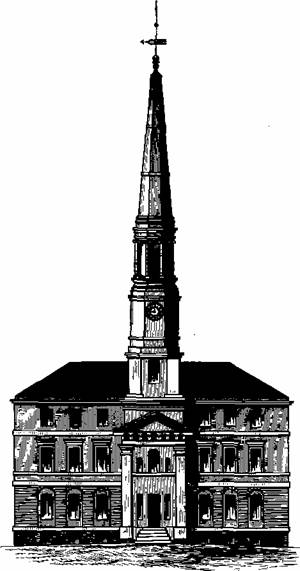
It will be here seen that Baine
projects the flight of steps considerably in front of the Tower; a
"moveable flap" or small draw-bridge would connect the top of the stair
with the main door, which, for protection, would be drawn up flat upon the
door at night. It is now, of course, impossible to form a correct opinion
as to how the Tower was fortified. Besides being fortified by nature, by
"flood, wood, and field," it would no doubt be artificially
strengthened by such appliances as the engineers of the time could
best devise. We have introduced "the sunk draw-bridge" as one of the
appliances to be an obstacle in the way of an enemy. It is very likely the
foundation portion of the building would be splayed, spreading outwards,
and "outer-wall’d" all round to a considerable height from the
ground. We have thrown into the view a fanciful side wall in order to show
that it would not be the narrow contracted edifice as some few have
imagined it to have been. It is probable that the Tower contained at least
twenty apartments of the dimensions of those primitive times, and in the
coped attic
there would be many more little rooms for servants, attendants, &c.
The site of the Tower, the nucleus
of Dunfermline, is still to be partially traced on the north-west flat top
of a small peninsular hill, the Tower Hill, at a height of about
seventy feet above the beautifully curved rivulet which sweeps round its
base. This hill is now in the policy of Pittencrieff, about 180 yards west
of the church steeple. In the north-west top are still to be found small
shapeless fragments of the south and west foundations. The length of the
south fragment is thirty-one feet, that of the west wall forty-four feet.
These fragments are about eight feet in height and six in thickness. In
1790 John Baine, Civil Engineer, Edinburgh, found that the south wall, was
thirty-one feet four inches long, the west wall thirty-five feet six
inches.
The Tower, from the oldest wax seals
attached to charters, appears to have been a stately, massive building of
about fifty-two feet from east to west and forty-eight feet from north to
south, and consisted of two storeys, and, as just noted, may have had,
attic included, about twenty small "eleventh century appartments"
in it.
Mercer, in his "Dunfermline Abbey, a
Poem," alluding to the locality of the Tower, its rocky steepness, and
difficulty of approach by man or beast, as told by Fordun, says—
"Hard by, a mount with flatten’d top
Uprears its rugged brow;
Its sides are broken, rocky, steep,
That hardly there a goat might creep;
A rivulet runs below,
"And winding, sweeps around the
mount,
Forming a lovely arch;
Then down the glen, with babbling din,
O’er crags, through trees, as it may win,
Pursues its destined march."
—(Mercer’s Dunf Abbey,
pp. 6, 7; An. Dunf., date 1070.)
P.S.—In some of the Pittencrieff charters, the
Tower-hill is designated "Montaculum"—i. e., the little hill;
and a modem author, whether by mistake or not, has a new reading to a
favourite old ballad, viz., instead of,
"The king sits in Dumferling toun,
Drynking the bluid-red wyne," &c.,
our author renders it,
"The King sits in Dunfermline Tower,
Drinking the bluid-red wine," &c.
which appears to us to be a more correct rendering;
because the king alluded to would be more likely to practise
wine-drinking in the tour, his residence, than in
the toun.
CULDEE ESTABLISHMENT AT DUNFERMLINE.
There appears to have been a "Culdee" settlement at
Dunfermline at a very remote period; but regarding its size, structure,
and when built, history and tradition are alike silent; it would, however,
be between A.D. 570 and 1070.
Like other Culdee places of worship, it would probably be small in size,
and somewhat rude in structure, capable of accommodating about fifty
worshippers. This "humble hallowed cell" probably stood on or near to the
ground on which the Abbey in aftertimes stood. Not a vestige of it now
remains, which somewhat favours the idea, that it had been removed about A.D. 1172-1175, when the church of Malcolm and
Margaret was opened for worship. In these pre-historic times, there were
several Culdee churches or chapels in Fife and Fothrick,—viz., at
Kirkheugh (St. Andrews), Kirkcaldy, Abernethy, Lochleven, Pittenweem,
Balchristie, Isle of May, Portmoak, Bolgin, Culross, Dunfermline, and
Inchcolm. For further remarks regarding the Dunfermline Culdee Church, see
Annals Dunf on "Founding of the Church," under date A.D. 1072.
ST. MARGARET’S HOPE AND St
MARGARET’S STONE.
The Royal Exiles, Edgar the Atheling, his mother,
sisters, and retinue, disembarked in the Forth. The exact spot is not
known; but it is likely it would be at or near to the rocky peninsula on
which the castle of Rosythe now stands. The beautiful Bay, immediately to
the west of this locality, has
from time immemorial,
been known as Sinus S. Margaretae, or
ST. MARGARET’S HOPE.
(Fordun, lv. c. 16.) Since it is, now well known that
original names of places have undergone so many changes, it is not
improbable that Rosythe had its name mutilated. It is not mentioned in
history until about 300 years after the landing of the Exiles. May not
the original name have been Ross-hythe, Ross, a promontory, or
peninsula; and hythe, or hithe, in Anglo-Saxon, a landing
place? There are still some landing places that retain their
Anglo-Saxon etymologies, viz., Rotherhythe, or Rotherhithe, London,
and the seaport town of Hythe in Kent, &c. This Ross-hythe would be
a much more convenient place for the disembarkation of the Royal exiles
than any point between it and North Queensferry. Is it not therefore
probable that the landing of the exiles was effected
at this promontory, the Rosshythe, the landing place at the promontory?
The
writer in 1846 wrote to several magazines and newspapers letters on this
subject, which were well received. He still continues of the same opinion,
viz., that the Royal Exiles disembarked on Rosythe peninsula.
St Margaret’s Hope has long been taken advantage of by
vessels during the prevalence of storms of easterly winds, and a more safe
retreat it would be difficult to find. Mercer,
alluding to it, says—
"It is a sheltered, safe retreat,
For tempest-driven vessels meet;
And ever since that day so fam’d
St. Margaret’s Hope it has been named."
The eastern part of this bay is about 4 1/2 miles SSE.
from the tower of Malcolm III. at Dunfermline; Rosythe about 4 miles S.
On the arched roof of the staircase in Pennicuick
House, near Edinburgh, there are laid down paintings of the landing, the
marriage, and the nuptial feast of Malcolm and Margaret, by the celebrated
painter Runciman.
We have now to refer to
ST. MARGARET’S STONE.
It is an old tradition that Margaret, while walking
from the scene of her landing to Dunfermline, complained of fatigue, and
on coming to the "huge Saxon stone" on the road, two and a-half miles
southeast of Malcolm III.’s residence, is said to have for a while rested
herself on it, and that on her frequent "journeys toe and froe" she often
used it as a rest. The neighbouring farm on the west takes its name from
this traditional circumstance, and is called St Margaret’s Stone Farm. In
1856 this stone was removed to an adjacent site by order of the Road
Surveyor in order to widen the road, which required no widening, as no
additional traffic was likely to ensue, but the reverse; it is, therefore,
much to be regretted that the old landmark was removed. It is in
contemplation to have the old stone replaced on its old site (as nearly as
possible), and made to rest, with secure fixings, on a massive base, or
plinth-stone. The following drawing of the stone is taken from one we made
in 1825:-
This large stone, which has long had the name of St.
Margaret’s, is probably the last remnant of a Druid Circle or a Cromlech,
and may have been placed here even before the beginning of the Christian
era. At this early period the road would be a narrow "foot-way" or a
"bridle-path." (For notices of St Margaret’s Stone, see the Histories of
Dunfermline, and Topographical Works.) |

