|
The earliest lines of
communication through a district must on the whole have followed the
main courses of rivers and streams. Old drove roads crossing natural
routes transversely often ascended to the top of intervening ridges;
but the openings in hills by which side streams enter the main
valley must have been the general routes. This is plainly proved by
the frequent occurrence of strongholds and afterwards towns at gaps
leading into the hills ; the former as a check on raiders, the
latter in more peaceful times as markets.
The Roman route
through central Scotland came into the modern district of
Forfarshire near Coupar Angus, passed Cardean, Kirriemuir, and
Battle Dykes (three miles north of Forfar), and crossed the South
Esk near the influx of Noran Water. Hence it extended to War Dykes
(three miles north of Brechin), and at Kingsford crossed the North
Esk and entered the Mearns. Traces of this road are still visible in
parts, and at one place—between Reedie and Kirriemuir—the modern way
coincides with it. This route is punctuated at regular intervals
with the remains of Roman camps. Between Cater Milly (near
Invergowrie) and Haerfaulds (five miles south-east of Forfar) there
probably was a subsidiary route affording the Romans communication
with their ships.
Centuries were
destined to elapse before any pathways at all comparable to the
Roman roads were constructed. Yet there must have been tracks
leading to bridges and fords across the rivers. Until the close of
the eighteenth century, the main road north and south through
Strathmore crossed the bridge at Brechin.
The constant need for
communication between such centres as Dundee, Forfar, Glamis,
Brechin, Arbroath, and Montrose would early lead to the formation of
beaten tracks, which would afterwards become roads. In Dundee the
old roads that led to the neighbouring burghs are still the main
arteries. If we remember the importance of Arbroath with its abbey,
Brechin with its cathedral, and Forfar with its royal residences, we
cannot think of these places as being isolated. In this connection
it is interesting to note the existence of the “King’s Cadger’s
Road,” a track as broad “ as the length of the millwand or rod by
which a mill-stone was trundled from quarry to mill.” This road
began at the fishing village of Usan and ran north-west to Forfar.
By means of it fresh fish was daily conveyed to the Court. This
royal road was perhaps only a bridle path. At all events heavier
articles than fish had to be conveyed through the county on pack
horses. For instance, slates and pavement slabs quarried in Glen
Ogilvy were carried on horseback to Dundee. In time panniers were
superseded by rough sledges dragged over the ground, and these in
turn by tumbrils, or carts of an extremely primitive kind. But with
the improvement of vehicle, improvement of road had to keep pace.
Forfarshire is now
abundantly supplied with excellent roads. If we consult a cycling
map in which the various highways are graded we shall find that the
best are
(1) the Perth to
Aberdeen road, which follows the centre of Strathmore by way of
Coupar Angus, Forfar, Brechin ;
(2) the road from
Dundee to Perth; (3) the coast road from Dundee to Arbroath,
Montrose, and the north; (4) the road from Arbroath to Forfar and
Kirriemuir; and (5) and (6) those which connect Brechin with
Arbroath and Montrose. Roads extending in a northerly direction from
Dundee, though of first rate surface, are necessarily hilly : they
lead severally to Coupar Angus, Meigle, Kirriemuir, and Forfar.
There are many subsidiary and farm-service roads ; and each of the
highland glens is supplied with at least one good thoroughfare.
Forfarshire has no
canals, though a system of them was projected. In a map published by
Robert Stevenson, C.E., in 1819, a canal was planned to begin at the
Forth and reach Perth by Dunfermline, Kirkcaldy, Strathmiglo, and
Newburgh. Then it was to extend to Coupar Angus, Forfar (with a
branch to Arbroath), Brechin (with a branch to Montrose), Stonehaven,
and Aberdeen. From this plan Dundee was excluded probably because of
its easy means of communication by water with Perth and the coast
towns of the adjoining counties. In the early forties of last
century Glasgow was reached from Dundee via Leith and the Forth and
Clyde Canal in as many days as it now takes hours to go by rail.
The first railway
line in Forfarshire, and one of the very earliest in Scotland, was
that connecting Dundee and Newtyle, completed in 1832. Its total
length was 10½ miles. At three steep inclines the train had to be
raised or lowered by means of wire ropes worked by stationary
engines. For some years horses were employed to haul the trains
along the more level portions of the track.
The Caledonian and
the North British Railway Companies have important parts of their
systems in Forfarshire. The main Caledonian line passes through the
heart of Strathmore and throws out branches to Blairgowrie, Alyth,
Kirriemuir, Brechin, Edzell, Arbroath, and Montrose. An important
line runs from Perth to Dundee and from Dundee via Arbroath and
Montrose to Aberdeen. A direct line connects Dundee with Newtyle,
and another Dundee and Forfar.
The North British
line, after crossing the Tay, runs north-eastwards by the coast
towns and forms with the Caledonian beyond Montrose a joint line to
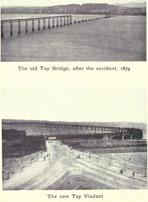
Aberdeen. The present Tay Viaduct, one of the longest in the world,
superseded the first Tay Bridge, which was destroyed during a
terrific gale in December, 1879. The new bridge, which carries a
double line of rails, forms one of the main links in the east coast
route between London and the north.
There is an extensive
system of tramways in Dundee and district. The line extends from
Ninewells to Broughty Ferry and Monifieth, a distance of seven
miles, while to the north-west and north it reaches Lochee and
Downfield, the latter a thriving suburb. |

