|
There are several glens in the parish which possess
all the beauty and charm that result from a combination of wood and
stream and rifted rock, with the ever-changing light and shade that
afford such pleasure and delight to persons of a contemplative and
poetic nature. Of these, perhaps the finest is Killoch Glen. This
picturesque and romantic ravine is situated on the southern slope of
the Capellie range of hills, nearly opposite the town of Neilston.
Both its banks are finely wooded with well-grown trees, and it has
been celebrated in song as the early home of the crawflower,
anemone, and primrose. The glen is a comparatively short one, and
consists of two parts, the upper and the lower glens. The trap
formation at the top of the upper glen which separates it from the
hollow meadow-land beyond and to the west of it, bears evidence of
having been worn down by the overflow of water, probably from a lake
formed there by the ponded-back water of the Capellie burn that now
flows past the old mill and under the bridge on the Capellie road.
The upper reach of the glen is short but picturesque, and the
descent from the trap which separates it from the lower glen is
rapidly made by a series of broken rocks, and as the water plunges
over them a succession of foaming white falls is produced, which,
when the burn is in flow, have a grand appearance, especially when
viewed from below. Tannahill and his friend Scadlock have both sung
the praises of this truly delightful glen. In times of drought, when
the burn water is low, many pot-holes are observed in the bed of the
stream. In some places these have been worn into one another, giving
rise to many fantastic shapes, which have been from time immemorial,
in one way or another, associated with “The Witch of Killoch Glen.”
The smoother parts between the holes are her “floor,” and her
“hearth”; while the cavities, according to their shape and depth,
are her “cradle,” her “water-stoups,” and her “grave”; and it is
surprising how these objects are outlined in the part of the glen
referred to.
“Down splash the Killoch’s wimpling wave,
As through the glen the waters rave,
Far o’er the witch’s eerie grave,
Frae crag to linn,
Yon beetling rocks, they wildly lave,
Wi’ gurgling din.”
The Killoch burn, very shortly after leaving the
glen, as already stated, joins the Levern.
The Kissing Tree.—From Killoch Glen across Fereneze Braes to Paisley
there is, and has been from time immemorial, a footpath, or
right-of-way. From this path on the top of the hill on an early
morning in summer, when the sun’s rays are bursting athwart the
broad expanse below, one of the finest and most extensive views is
to be had of the surrounding country, a view which will well repay
the early riser for his trouble. Formerly the “Kissing Tree,” which
was well studded with nails, stood on the crest of the hill by the
side of this walk, connected with which tradition has it that the
swain who succeeded in driving a nail into its gnarled trunk at the
first blow was entitled to claim the osculatory fee. The tree has,
however, long since disappeared, carrying with it the nailed record
of many victories.
Midge Glen, or Image Glen.—This glen is inferior in beauty to none
of its size. In general contour it presents all the evidence of
having, through the ages, been scooped out of the trap formation
which forms its bed by the action of the river Levern. About
half-way through the. glen there is a sudden bend in it, the river
being turned from a nearly eastern to a nearly northern course, due
to the solid trap on the eastern hank, against which the water
impinges, having resisted its denuding power and deflected it from
its course. The river enters the head of the glen under a quaint old
bridge, immediately after leaving the “Links of Levern.” These links
are remarkable in the regularity and completeness of their formation
and in the way they wind about through the meado^-land above the old
bridge, in what is doubtless the silted up remains of an ancient
loch. Immediately on entering the glen, where it passes the ruins of
the old grain mill, the stream is dashed over a series of shelving
rocks which form two beautiful waterfalls. The banks of the defile,
especially the southern bank, as has been stated when dealing with
the Levern, are well wooded, and the “right-of-way” through the
glen, an old church path, is a delightful walk, as throughout its
course it overlooks the bed of the river, the waterfalls, and the
old mill. The walk seems to be much enjoyed by the people.
Polleick Glen.—This is a delightfully wooded glen, situated on the
outcrop of the carboniferous formations at the west end of the
village of Uplawmoor. It is not a long glen, but in its course there
are several fine waterfalls, and some charming “bits” from an
artistic point of view. The stream which flows through it rises in
Dumgraine moor and the meadow-land of Linnhead farm, and passes
under the bridge on the road leading from Uplawmoor past South
Polleick. On leaving the glen, it flows past Caldwell station and
joins the Lugton just immediately after the latter has left Loch
Libo.
Colinbar Glen.—This glen extends from Wraes grain mill to Arthur-lie
bleaching works, and has some fairly good wood on its banks. Kirkton
burn flows through it, and at its eastern end there is a pleasant
walk under the shadow of some trees.
Wauk-Mill Glen.—This glen reaches from the eastern or lower
reservoir of Gorbals gravitation works, at Balgray, to Darnley old
mill, a ruin on its right bank. It receives the overflow or service
water, which represents the continuation of the Brock burn, after it
has been ponded up, with other streams, in the reservoirs. Nature
has cut this glen through the outcrop of the carboniferous
formations of the Levern valley, the coal, clay, and lime-stone of
which are plainly visible on the northern side of the glen, where
they are being wrought by adit workings. The filters connected with
the reservoirs above are placed to the south of the glen, and
between them and the southern margin of the stream there is a very
agreeable walk, from the road leading from Barrhead to Upper Pollok
castle, through the glen to Darnley on the Glasgow Road. This ravine
is highly picturesque, being beautifully wooded with tall,
well-grown trees, under whose umbrageous shadows ferns of many kinds
grow in great luxuriance, and the stream murmurs in tranquil
solitude.
Evidence of Glaciers in the Parish.
That the valley of the Levern, like most of the great
valleys of Scotland, has been traversed by glacier ice during the
“great winter of our land” is amply borne testimony to by the
grooved markings left along the Fereneze and Capellie hill slopes
and alongside of Loch Libo on the exposed sandstone formation at
Uplawmoor wood ; and also by the famous inter-glacial beds in Cowden
Glen, and especially by the great glaciated surface on the
lime-stone formation at the Lugton outlet of the valley, in addition
to large sandbanks and gravel formations to the east of the loch and
at Killoch Glen, Gateside, and other places.
The direction of these groovings seems to indicate that the glacier
movements were in a north-easterly to south-westerly direction, from
probably what was the great ice field of our country at the time,
the dreary elevation of the moor of Rannoch. From the height at
which the markings can be traced on Capellie hills, the ice seems to
have quite filled the valley, and before denudition took place the
valley had probably more trap ash in it than at present. As the ice
age began to pass off and the rigours of the climate became
ameliorated, the valley glacier would seem to have been retarded in
its westward progress by the trap formations which so much narrow
the valley at the entrance to Cowden Glen, during which period the
sand, boulders, and boulder clay, were probably deposited—found in
such abundance in this locality as to suggest the existence of a
moraine.
When laying the sewage pipes from Levernbanks to Crofthead; and in
making the septic tank at Killoch Glen, great beds of sand had to be
dealt with, that at Killoch being quite stratified ; and everywhere
there were abundance of boulders. During operations for the
enlargement of Crofthead Thread Works some years ago, extensive sand
beds were also passed through. The cutting covered several acres,
and at the face the embankment had a depth of thirty feet. “At this
depth the sand was found to rest upon boulder clay, and this again
upon volcanic ash. But towards the surface the ash was found
interbedded with loose sand.” The boulders exposed during the latter
operation varied in size, many of them weighing several tons, and
requiring to be shattered with dynamite before they could be
removed. They were striated and non-striated, angular and
sub-angular, and many of them had travelled far.
In the course of constructing the Lanarkshire and Ayrshire Railway
in this neighbourhood, one of the cuttings passed through a
considerable extent of sand and gravel on Kilburn farm, evidently an
extension southward of the corresponding formations quarried for
many years on the adjoining farm of Holehouse. It was observed at
the time, that these deposits were laid down in such well-defined
stratified beds as to indicate the operation of water, probably some
ancient lake in the locality, which in some remote way had been
associated also with the valley glacier, ponding back the waters of
the higher lands, now the Levern, in the direction of Midge Glen,
where there is evidence that a much larger body of water once
existed than passes through it at the present day; at which time,
also, the natural channel of outlet for the stream would appear to
have been more easterly than the present course through Crofthead
mill.
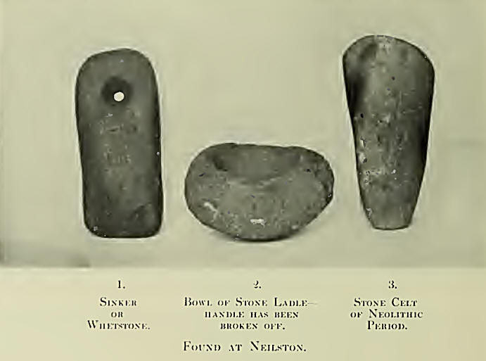
It is quite in consonance with the existence of such
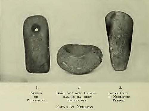
a lake, that some years ago, in a field on Holehouse farm, which
would then be covered by its waters, a beautifully finished,
evidently neolithic stone celt was found, which is in the writer’s
possession. A drain was being cut in one of the lower fields to
collect water for the supply of the then Holehouse laundry, during
an interdict of their supply from the Levern, and the celt was found
at an unascertained depth below the present land surface. In an
adjoining field was also found a stone sinker, or possibly a
whetstone. This stone is 5 inches long, by 2½ broad, and has a hole
through one end of it, which has been formed by drilling from either
side. The stone is in the writer’s possession. How long this lake
may have continued, there is nothing to indicate, but it most
probably existed well into neolithic times, when some primitive
savage or native, paddling over its surface, or possibly engaged in
the more deadly enterprise of war, lost the celt overboard, to be
subsequently restored to light by a modern drain-maker; whilst the
sinker, which the peaceful ploughshare revealed in long subsequent
ages, may have broken away from the primitive tackle. These
discoveries open up wide fields for reflection. The stone of which
the celt is made is “Water of Ayr-stone,” and as no such stone is
found in this locality, we have evidence of very early
trading—barter possibly, or possibly worse— or the celt may have
been part of the booty after some tribal battle with their
neighbours from the district of Ayr, and subsequently lost from the
canoe in the lake. As to the stone sinker, one can readily imagine
what grief the savage fisherman—not this time a disciple of honest
Isaac, but rather, a very early forerunner—would display when he
found that his tackle had given way, and the sinker it had cost him
so much pains and trouble to drill and make had gone to the bottom,
and was lost to him for ever.
The Lands and Properties of Neilston.
King David I., when he ascended the throne of
Scotland, was forty-four years of age ; of mature judgment, and
possessed of some education and refinement from his connection with
the Court of England, where his sister was Queen to Henry I. He was,
besides, a baron of England, and possessed large estates in that
country. His friends and followers from England were chiefly Normans
who came to settle in Scotland, as many of their fellow-countrymen
had done before during the reign of his father, Malcolm Camnore. By
them the feudal system, already established in England by the
Conqueror, and introduced into our country in the reign of
Alexander, became established, and from them most of the ancient
nobility of Scotland claim to derive their Norman descent. Prominent
among those who followed the king from England was Walter Fitz
Alan,— a scion of a Norman family in Shropshire, whose ancestor, the
first Walter, had come to England with William the Conqueror, and to
Scotland in the reign of Can more, to whom he acted as Dapifer. For
him the king seemed to entertain the highest esteem and regard, and,
for some eminent but unnamed special services, appointed him Lord
High Steward of Scotland —Senescallus Scotia?—an office which
afterwards became hereditary in that family. In addition to this
high favour and signal reward, and to enable him the better to
maintain his exalted position, large gifts of land were made to him,
including nearly the whole of what is now Renfrewshire, and much of
Ayrshire—King’s Kyle and Kyle Stewart in that county—lands which in
the beginning of the fifteenth century were erected into a Princedom
by King Robert III. for his son. Amongst the retainers of the High
Steward, who had accompanied him northward to Scotland in the king’s
service, was Robert de Croc, whose ancestors appear to have also
come to England with William the Conqueror, although there is an
opinion that he may have been of Saxon origin, from the prefix “de”
being seldom used in his name. Following the example of the great
Norman monarch, who had divided the rich lands of England amongst
those followers who had helped him in the great conquest, the
Steward would appear, almost immediately after receipt of the royal
honours and gifts from King David, to have begun sub-dividing them
with his retainers and followers, and accordingly, amongst the
earliest references there is to the lands of Neilston, The Register
of the Monastery of Paisley, circa 1170, shows that already these
lands, including nearly the whole of the parish, were in possession
of the ancient family of de Croc, whose principal residence was
Crookston, probably so called from the owner’s surname, the lands
being then named Crooksfeu. Subsequently to this date the lands of
Neilston passed into possession of a collateral branch of the same
illustrious family by marriage, when Robert Stewart, third son of
Walter, second High Steward of Scotland, took to wife the daughter
and heiress of Robert de Croc, designated of Neilston, as about the
twelfth century the greater part of the parish belonged to that
family. The lands of Glanderston formed part of the lordship of
Neilston, and, through the marriage of Lady Jane Stewart, also of
the High Steward’s family, with John Mure of Caldwell, they came
into the Caldwell family. John Mure of Caldwell disponed the lands
to his second son, William Mure (1554), in whose family they
remained until 1710, when the Mures of Glanderston, on the failure
of the elder line, inherited the Caldwell estates, and thus united
the lands of Glanderston to Caldwell again, after they had been
separated for a period of one hundred and fifty years. In 1774,
these lands were acquired by Speirs of Elderslie from Mr. Wilson,
and in that family they still remain.
In 1613, the Laird of Glanderston married Jean, daughter of Hans
Hamilton, rector of Dunlop. This lady’s brother, James, rose to
eminence in Ireland, being created first Viscount Clandebois, and
latterly Earl of Clanbrissil, honours which became extinct in 1798.
The Laird of Glanderston had issue by his wife, Jean
Hamilton:—William, afterwards Laird of Glanderston ; Ursula, who
became the wife of Ralston of that Ilk; Jean, who married John
Hamilton of Halcraig; Margaret, who became the wife of the minister
of the Barony Kirk, Glasgow. This somewhat eccentric clergyman,
Zachary Boyd, whose bust occupied a niche over the west arch in the
inner quadrangle of the old University in High Street, translated
parts of the Bible into a kind of rhyme, of which the following
quatrain may be taken as a specimen :—
“Jonah was three days in the whaul’s bellie,
Withouten fyre or caunill,
And had naething a’ the while,
But cauld fish guts to haunil.”
The MS. is in the College Library, Glasgow, but was
never published.
Lochliboside, the property of J. Meikle, Esq., of Barskimming and
Lochliboside.—This estate extends along the north side of the
valley, past Shilford, and joins that of Caldwell at Loch Libo, and
there is a charter to show that it was from an early period a
possession of the Eglinton family: “Charter by King Robert Second to
his dearest brother Hugh of Eglinton, knight, of the lands of
Lochlibo within the barony of Renfrew : To be held by Hugh and
Egidia his spouse, the King’s dearest sister, and their heirs,
Stewards of Scotland, for giving yearly ten marks sterling for the
support of a chaplain to celebrate divine service in the Cathedral
Church at Glasgow.” Dated at Perth, 12th October, 1374. In the
fifteenth century it was still an Eglinton possession, and became
pledged in a curious way as part of a marriage dower: “Indenture
between Sir John Montgomery, Lord of Ardrossan, and Sir Robert
Conyngham, Lord of Kilmaurs, whereby the latter ‘is oblgst to wed
Anny of Montgomery, the dochtyr of Sir Jone of Mungumry, and gyfe to
the said Anny joyntefeftment of twenty markis worth of hir mothers
lands.’ Sir John is bound to give Sir Robert for the marriage three
hundred merks and forty pounds, to be paid by yearly sums of forty
pounds from the lands of Eastwood and Loychlebokside.”
Neihtonside and Dumgraine lie to the south-west of the parish. A
large part of the property is rough moorland and marshes. During
some estrangement between Queen Mary and the Lennox family, we find
it treated as rebellious, and under date 36th April, 1548,—this was
before the death of Darnley, which took place on 9tli February,
1567,—“The Queen (Mary) granted to Robert Master of Sempile and his
heirs and assignees for services rendered by him, his friends and
relations, etc., the lands of Crookston (Crooksfeu), and
Neilstonside, also Inchinnan, with castles, towers, mills, multures,
fishings, etc., the advowsons of the churches, benefices of chapels
of the same, which fall to the Queen by their forfeiture of Matthew,
sometime Earl of Lennox.” In 1755, Neilstonside belonged to John
Wallace, a lineal descendant of Scotland’s great liberator, but is
now the property of Mr. Speirs of Elderslie. “The principal branch
of the Wallaces of Elderslie failing in the person of Hugh Wallace
of Elderslie, who died without succession. John Wallace of
Neilstonside was his heir.”4 There would appear to have been at one
time an old Celtic town of Dumgraine, near Waterside ; that the
castle of Walter Fitzallan, the first High Steward of Scotland,
appointed by King David I., circa 1140, was built at this place on
the south side of the Levern. (Semple.)
The lands of Fereneze are now the possession of Admiral Fairfax and
Auchenback, long a possession of the Earls of Glasgow, was purchased
some years ago by David Riddell, Esq., Paisley.
The estates of Capellie and Killochside are owned by A. G.
Barns-Graham, Esq., of Limekilns and Craigallion.
Chappell, the site of an early religious house attached to the Abbey
of Paisley, is the property of Joseph Watson, Esq., writer, Glasgow
and Barrhead.
But since the period of the early possessors of the lands now
enumerated, time has wrought enormous changes in the parish. In the
greater number of instances all that remains to show that these
ancient and noble owners through hundreds of years ever held
possession here, are a few ruins fast crumbling into oblivion, as
their owners have done long ages ago. Cowden Castle, which gave the
first title of Lord to the family of Cochrane, afterwards Earls of
Dundonald, is now a shapeless ruin on the hillside in Cowden Glen;
the lands of Lochlibo, at one time the property of the Earl of
Eglinton; Raiss Castle, east of Barrhead, in 1488 the property of an
ancient family named Logan, subsequently a possession of Lord Ross,
and afterwards of the Earl of Lennox, who granted it by charter to
Alexander Stewart, consang. suo, and of the family of Lord Darnley,
a son of whose house became the unfortunate husband and king to
Queen Mary of Scots ; the broad acres once owned in the parish by
the Earls of Glasgow,—have all changed hands, so that the motto,
“New men in old acres,” might very fittingly be applied to the
greater number of the proprietors of land in the parish of Neilston
at the present day.
Roads and Highways.
In few things have there been greater improvements in
recent times throughout the country generally, than in the condition
of the public roads that pass through parishes from one centre of
population to another ; and the parish of Neilston has participated
in this modern movement. The Romans—that mighty and intrepid
people—in the great military ways they constructed in their march
northward through Britain, were possibly the earliest road-makers in
our country; and their works have never been excelled for solidity
of construction. But it does not appear that the inhabitants
profited much by their example in road-making; and it was not until
Telfer and Macadam, the great engineers— especially the latter,
whose name is still preserved in the designation, “Macadamised
roads”—demonstrated the principles of road construction, that any
real improvement was effected in this direction. Before their time,
the roads were in such a wretched condition that travelling was
difficult and dangerous. We are told that in rainy weather there was
only a slight ride in the centre of the road, between two channels
of deep mud, and that, so late as 1669, the “Flying Dutchman”
stage-coach took thirteen hours to cover fifty-five miles, which was
considered a wonderful feat; and that even in the vicinity of the
Scottish capital the roads were such, that riding was always
preferred. When the military roads constructed by General Wade
through the Highlands made such a thing practicable, we learn that
his chariot, drawn by six horses, produced a great sensation in his
progress through the territory of the clansmen. It had been brought
from London by sea, and, when passing along the roads, the people
ran from their huts, bowing, with bonnets off, to the coachman, as
the great man, altogether disregarding the quality within. In those
days burdens were mostly carried on horseback ; and, to give the
animals secure footing and ensure them against sinking under their
loads, the roads in general were so made as to secure a rocky
bottom, and no attempt was made, by the slightest circuit, to avoid
steep places. For example, in making the old Glasgow and Kilmarnock
road, which skirts the southern border of our parish, the writer was
credibly informed by a gentleman of long experience as a road
surveyor, that the method adopted by Sir Hew Pollok, Bart., of Upper
Pollok, and the gentlemen associated with him in laying off the
undertaking, was to proceed to the top of one hill and then look out
for another in the direction they meant to go, and so continue; the
result being, that the road has a good and substantial bottom, but
is quite a “ switchback,” a constant succession of up and down hills
for much the greater part of its way, and therefore ill-suited for
vehicular traffic. So much was this found to be the case, as to
necessitate the construction of the “ New Line” of road some years
after, when the stage-coach had to be provided for. In our own
parish, where the Turnpike Act was long in being adopted (though
introduced into Scotland in 1750), the condition as regards roads
was nearly identical. The Kingston road to Kilmarnock being such a
“switchback” of hills and hollows, as to necessitate the building,
about 1820, of the new turnpike road from Glasgow, through the
Levern valley by Lugton, to Kilmarnock, Irvine, and Ayr, at a cost
of about £18,000. The parish roads at this period were even more
deplorable, before Statute Labour was converted into money payments,
in 1792.
Statute Labour Roads.
Formerly, the roads of the parish other than
turnpikes, being intended for local communication only, were kept up
by tenants, cottars, and labourers giving so much of their personal
labour yearly as served for their maintenance; the consequence of
this loose arrangement was, that not unfrequently they were allowed
to lapse into a very dilapidated condition. The writer remembers
being told by a Neilston farmer, that in his young manhood—the
beginning of the nineteenth century—in the parish of Kilmacolm,
where his father was also a farmer, he was sent with a load of hay
to near Govan, and that the condition of the roads was such as to
quite preclude the use of any kind of cart, and that the load of hay
had to be taken on the horse’s back. This, however, was a common
enough practice at the j:>eriod referred to in country districts,
and it is to this practice that we owe the term “load,” being just
as much as a horse could carry conveniently as a load of any
commodity. In the present day, to realize something of the condition
of such roads in our parish, it is only necessary to travel over the
relic of a reputed once public thoroughfare that passes from the
east side of Harelaw dam on the Moyne road, past Snypes farm to the
“Flush,” at the junction of roads from Barrhead and Neilston to
Mearns ; or the similar old road, the remains also of a once public
way, which passes along the top of the hill, by the farm of
Bank-lug, above Loch Libo, to Greenside and Dunsmuir road. But,
happily, these conditions are now gone, and by the Local Government
(Scotland) Act, 1889, the County Council now provides for the
maintenance of the highways, which include main roads and most of
their branches, everywhere throughout the parish, which, under the
superintendence of our vigilant surveyor, Mr. Robert Drummond, C.E.,
are kept in a thoroughly good condition ; while the bypaths, old
church roads, rights-of-way, and all roads other than highways, are
under the supervision of the Parish Council.

Toll Bars in the Parish.
Closely associated with the roads of the parish were
the tolls by which they were formerly kept up ; and, as this system
is now relegated to the limbo of past devices, not likely to be had
recourse to again, a few words regarding tolls may come to interest
those of a future generation who will know nothing of them from
practical knowledge. Toll primarily meant money paid for the
enjoyment of some special privilege or monopoly in trade. But
latterly it came to have a much broader meaning, and by Act of
Parliament, Customs of many kinds were recognised as
tolls—turnpikes, railways, harbours, navigable rivers and canals,
were all brought under its operation. Our interest, of course, rests
with the first of these, the turnpike, or road tolls. The first Act
of Parliament for the collection of tolls on the highways in
Scotland came into force, as already stated, in 1750. The principle
underlying this mode of taxation was, of course, “ that they who
used the roads should pay for their upkeep,” and at one period there
might have been a superficial sense of equity in this mode of road
upkeep, but after the introduction of railways, the whole position
was changed, and it soon became apparent that much injustice was
being practised on some branches of industry that others were
largely exempted from. For example, some large business concerns or
contractors, by the facilities railway stations afforded them, could
have quite a number of horses on the road from one year’s end to
another, and yet pay no toll ; while another contractor could not
move a load of coal from a pit, or stone from a quarry, without
having to pay toll dues on every cart. The toll bars were placed on
the turnpike roads by the Road Trustees, a public body empowered by
Act of Parliament to do so at their discretion; and they were
generally so placed as to intercept all horse or cattle or vehicular
traffic entering or leaving the parish, or passing through it. The
charges varied at different toll bars, but it is not apparent on
what principle, and vehicles varied according to the number of
horses by which they were drawn. At Neilston toll, on Kingston road,
the charge was 6d. for each gig and horse, 2d. for a riding or led
horse; Shilford toll the same ; Dovecothall toll the same; Kingston
toll was 4½d. for horse and gig, and l^d. for single horse; Dunsmuir
toll the same.
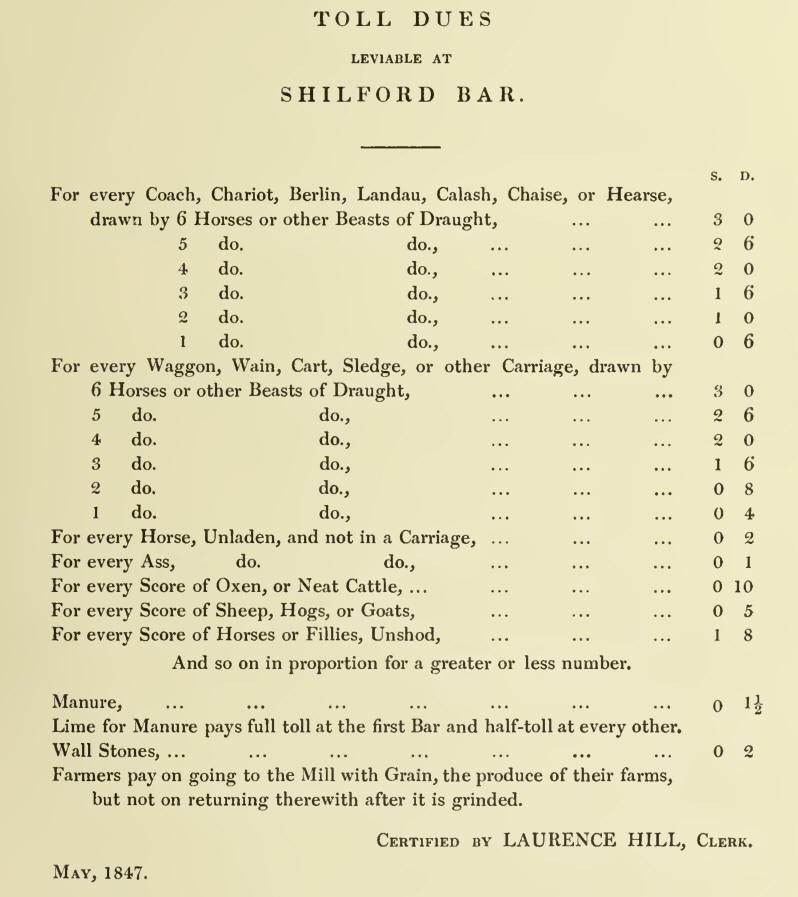
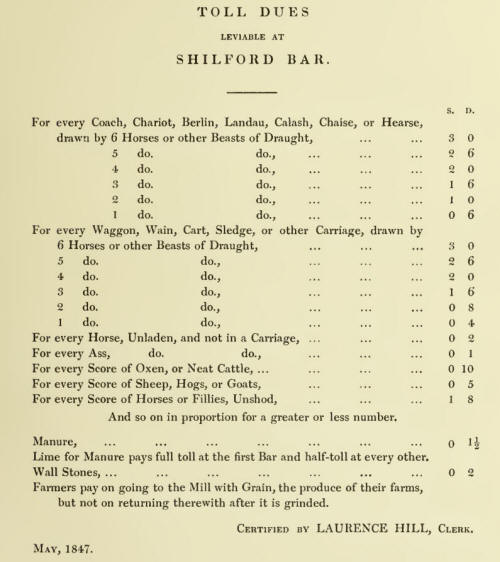
The following table indicates the dues leviable at most of the tolls
in the parish, a copy of which usually hung on a board outside the
tollhouse, for reference when the charges were disputed, as
sometimes occurred :—
The tolls were rouped annually, and, for our parish,
in Paisley. There was usually a dwelling-house attached to the toll
bar, in which the toll-keeper and his family resided ; gates, with
wickets for foot passengers at either end, were stretched across the
highway to intercept traffic ; and there was generally some one of
the family on the look out for traffic at night. This system of
collecting toll dues often entailed a considerable amount of
annoyance to the traveller ; as on a stormy winter day, or in a
hurricane of wind and rain in the middle of the night, when wrapped
up in waterproof or overcoat for protection—as was often the lot of
the country medical practitioner—it became necessary to strip to
procure the needful sixpence. But, happily, this clumsy mode of
tax-gathering is gone ; abolished by the “Roads and Bridges Act of
1878,” which came into force throughout Scotland, w here not
previously adopted, on 1st June, 1883. This arrangement applied,
however, to main turnpikes only; roads other than turnpikes being
dealt with under the Statute Labour Roads system until 1889, when
they were included as highways, and taken over by the County
Council. |