|
I have been
assisting Sandy McKay, and the Friends of Fallbrook with an
investigation of the early log house and additions on the Silver Creek
Property currently owned by the Credit Valley Conservation Authority.
The CVC had
expressed an interest in demolishing the house and "restoring" the
landscape (which I believe means removing hundreds of metres of dry laid
stone walls) so that it can be presented as a pristine natural habitat.
While I am a conservationist of sorts, and my sister is a marine
biologist who runs a research station in New Brunswick, the buildings
gave up some of their secrets when we conducted a test to date the
timber from the original log house, using dendrochronology. The pine log
used as the top plate on the south wall gave a firm date of 1855, which
was somewhat later than I might have expected, but one can never guess
as to the age of the structure, when the trees will tell you
unequivocally their own date of cutting.
The logs were
sawn, indicating that a sawmill was present, and after questioning
several people who had lived in the house, we met on site, and found a
mill race less than 100 yards from the front door. This mill race was a
crude, shallow ditch, but meant that someone had constructed a dam
across the creek, above the house. Examination of the creek showed that
the creek bed had been scaled and quarried for building stone, so it was
probably a masonry dam. Sure enough, traces of mortar and stones bedded
in both banks of the creek showed where the dam had been situated just
downstream from the millrace.
One of those
present indicated that there were foundations for an ice house,
downstream. We went looking for this and came across a narrow U-shaped
box which I recognized as the wheel pit for a large overshot wheel, not
an ice house. This meant that the owners had constructed a dam,
undershot saw mill, overshot grist mill and sluice running approximately
200 yards downstream on this beautiful little creek. The log house was
the miller's house. With the timber date in hand, I reviewed the land
registry from the public archives and determined that the Canada Land
Company, who owned vast areas of Ontario and were instrumental in
constructing mills, and roads, had sold this property to William McClure
early in 1855. He must have had a clear idea about how to proceed since
he started with a sawmill which would make the materials needed for the
construction of the house and grist mill. He was middle aged when he
bought the property, which explains why the attic had no finished floor
(as late as 1950) as one would have expected if it had been built by a
young scottish immigrant family with many "wee bairns". McClure and his
wife were undertaking a massive project at an age when many were
expecting grandchildren.
The land registry
demonstrates that after McClure sold the land, it passed through a
number of hands, in a temultuous round of lawsuits, claims and counter
claims, until the land value dropped by 95%, from nearly $6000 to $306.
What happened? Clearly the main asset was no longer present on the 26
acres of rocky wooded land. This suggests that the mill was gone,
perhaps destroyed in a fire, so we would like to pursue archaeology of
the mill site to see if this is what happened.
Traces of the
dam, millrace, and even a temporary camp near the sawmill have all been
identified by walking the site. Using aerial photos we also discovered
the outline of a native longhouse just 600 yards upstream from the
house. My archaeologist friend scoffed at being able to see these things
from the air, but I suggested that she use a newer computer and software
so she can make these discoveries for herself, since they are of
enormous help when trying to analyze an early pioneer site.
The regional
heritage committee expressed surprize when all of this information came
to light.
Sandy has asked that I send a copy of my preliminary report to
you for inclusion in your website. I am happy to do this, but must
qualify the report as being preliminary since much work must be done to
confirm what has already been observed, and expand upon the details.
Things like the surviving stone bridge also need to be studied since it
is likely that the McKays who purchased the farm in 1877 were
responsible for taking the remains of the mill dam and other structures
to be recycled yet again in another useful form.
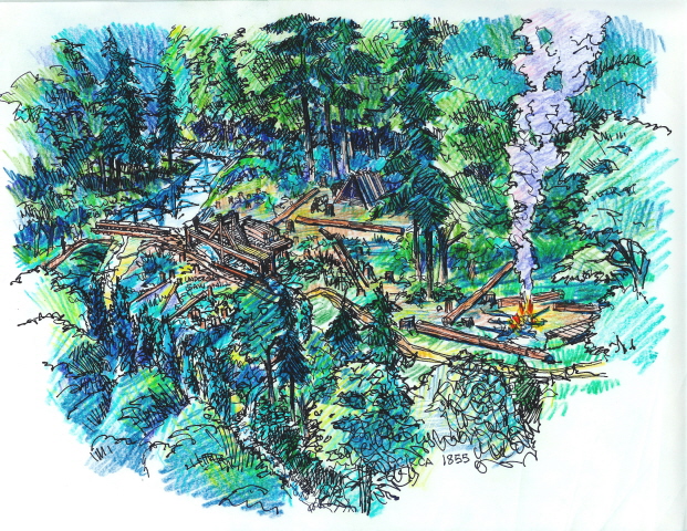
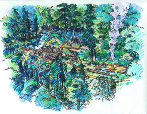
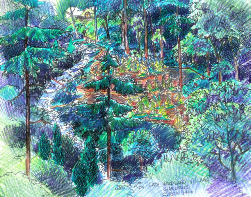
The two scanned
attachments show the site in 1855 as Wm. McClure was clearing the forest
and setting up his first sawmill, and much earlier when the native
settlement upstream included gardens scattered along the creek in the
vicinity of the house.
Please feel free
to share this on your website, but include copyright notice on the
materials, since I would not want these early findings to be taken out
of context on this or other sites.
sincerely
Tom Murison
p.s. The McKays were crofters evicted in the highland
enclosures, probably with 50,000 others from Sutherlandshire.
My paternal
Grandfather, Tom, emigrated from Mintlaw near Aberdeen at the age of 15
to farm in Saskatchewan.
Heritage Investigation Report
(pdf file) |