The "Western Sea"—Ardent
Duluth—"Kaministiquia"—Indian boasting—Pere Charlevoix—Father
Gonor—The man of the hour: Verendrye—Indian map maker—The North
Shore—A line of forts—The Assiniboine country—A notable manuscript—A
marvellous journey—Glory but not wealth—Post of the Western Sea.
Even the French in Canada were animated in their
explorations by the dream of a North-West Passage. The name Lachine at
the rapids above Montreal is the memorial of La Salle's hope that the
Western Sea was to be reached along this channel. The Lake Superior
region seems to have been neglected for twenty years after Radisson
and Groseilliers had visited Lake Nepigon, or Lake Assiniboines, as
they called it.
But the
intention of going inland from Lake Superior was not lost sight of by
the French explorers, for on a map (Parl. Lib. Ottawa) of date 1680,
is the inscription in French marking the Kaministiquia or Pigeon
River, "By this river they go to the Assinepoulacs, for 150 leagues
toward the north-west, where there are plenty of beavers."
The stirring events which we have described
between 1682 and 1684, when Radisson deserted from the Hudson's Bay
Company and founded for the French King Fort Bourbon on the Bay, were
accompanied by a new movement toward Lake Superior, having the purpose
of turning the stream of trade from Hudson Bay southward to Lake
Superior.
At this time
Governor De La Barre writes from Canada that the English at Hudson Bay
had that year attracted to them many of the northern Indians, who were
in the habit of coming to Montreal, and that he had despatched thither
Sieur Duluth, who had great influence over the western Indians.
Greysolon Duluth was one of the most daring spirits in the service of
France in Canada. Duluth writes (1684) to the Governor from Lake
Nepigon, where he had erected a fort, seemingly near the spot where
Radisson and Groseilliers had wintered.
Duluth says in his ardent manner: "It remains for
me, sir, to assure you that all the savages of the north have great
confidence in me, and that enables me to promise you that before the
lapse of two years not a single savage will visit the English at
Hudson Bay. This they have all promised me, and have bound themselves
thereto, by the presents I have given, or caused to be given them. The
Klistinos, Assinepoulacs, &c, have promised to come to my fort. . . .
Finally, sir, I wish to lose my life if I do not absolutely prevent
the savages from visiting the English."
Duluth seems for several years to have carried on
trade with the Indians north and west of Lake Nepigon, and no doubt
prevented many of them from going to Hudson Bay. But he was not well
supported by the Governor, being poorly supplied with goods, and for a
time the prosecution of trade by the French in the Lake Superior
region declined. The intense interest created by D'Iberville in his
victorious raids on Hudson Bay no doubt tended to divert the attention
of the French explorers from the trade with the interior. The Treaties
of Ryswick and Utrecht changed the whole state of affairs for the
French King, and deprived by the latter of these treaties of any hold
on the Bay, the French in Canada began to turn their attention to
their deserted station on Lake Superior.
Now, too, the reviving interest in England of the
scheme for the discovery of the North-West Passage infected the
French. Six years after the Treaty of Utrecht, we find (MSS. Ottawa)
it stated: "Messrs. de Vaudreuil and Begin having written last year
that the discovery of the Western Sea would be advantageous to the
Colony, it was approved that to reach it M. de Vaudreuil should
establish these posts, which he had proposed, and he was instructed at
the same time to have the same established without any expense
accruing to the King —as the person establishing them would be
remunerated by trade."
In the year 1717 the Governor sent out a French
lieutenant, Sieur De la Noue, who founded a fort at Kaministiquia. In
a letter, Do la Noue states that the Indians are well satisfied with
the fort he has erected, and promise to bring there all those who had
been accustomed to trade at Hudson Bay. Circumstances seem to have
prevented this explorer from going and establishing a fort at
Tekamiouen (Rainy Lake), and a third at the lake still farther to the
north-west-It is somewhat notable that during the fifty years
succeeding the early voyages of Radisson and Groseilliers on Lake
Superior, the French were quite familiar with the names of lakes and
rivers in the interior which they had never visited. It will be
remembered, however, that the same thing is true of the English on
Hudson Bay. They knew the names Assiniboines, Christinos, and the like
as familiar terms, although they had not left the Bay.
The reason of this is easily seen. The North-West
Indian is a great narrator. He tells of large territories, vast seas,
and is, in fact, in the speech of Hiawatha, "Iagoo, the great
boaster." He could map out his route upon a piece of birch-bark, and
the maps still made by the wild North-Western Indians are quite worthy
of note.
It will be observed that the objection brought by
the French against the Hudson's Bay Company of clinging to the shores
of the Bay, may be equally charged against the French on the shore of
Lake Superior, or at least of Lake Nepigon, for the period from its
first occupation of at least seventy years. No doubt the same
explanation applies in both cases, viz. the bringing of their furs to
the forts by the Indians made inland exploration at that time
unnecessary.
But the time and the man had now come, and the
vast prairies of the North-West,hiitherto unseen by the white man,
were to become the battle-ground for a far greater contest for the
possession of the fur trade than had yet taken place either in Hudson
Bay or with the Dutch and English in New York State.
The promoting
cause for this forward movement was again the dream of opening up a
North-West Passage. The hold this had upon the French we see was less
than that upon Frobisher, James, Middleton, or Dobbs among the
English. Speaking of the French interest in the scheme, Pierre Margry,
keeper of the French Archives in Paris, says: "The prospect of
discovering by the interior a passage to the Grand Ocean, and by that
to China, which was proposed by our officers under Henry IV., Louis
XIII., and Louis XIV., had been taken up with renewed ardour during
the Regency. Memorial upon memorial had been presented to the Conseil
de Marine respecting the advisability and the advantage of making this
discovery. Indeed, the Pere de Charlevoix was sent to America, and
made his great journey from the north to the south of New France for
the purpose of reliably informing the Council as to the most suitable
route to pursue in order to reach the Western Sea. But the ardour
which during the life of Philip of Orleans animated the Government
regarding the exploration of the West became feeble, and at length
threatened to be totally extinguished, without any benefit being
derived from the posts which they had already established in the
country of the Sioux and at Kaministiquia."
"The Regent, in choosing between the two plans
that Father Charlevoix presented to him at the close of his journey
for the attainment of a knowledge of the Western Sea, through an
unfortunate prudence, rejected the suggestion, which, it is true, was
the most expensive and uncertain, viz. an expedition up the Missouri
to its source and beyond, and decided to establish a post among the
Sioux. The post of the Sioux was consequently established in 1727.
Father Gonor, a Jesuit missionary who had gone upon the expedition, we
are told, was, however, obliged to return without having been able to
discover anything that would satisfy the expectations of the Court
about the Western Sea."
At this time Michilimackinac was the depot of the
West. It stood in the entrance of Lake Michigan—the Gitche Gumee of
the Indian tribes, near the mouth of the St. Mary River, the outlet of
Lake Superior; it was at the head of Lake Huron and Georgian Bay
alike. Many years afterwards it was called the "Key of the North-West"
and the "Key of the Upper Lakes." A round island lying a little above
the lake, it appealed to the Indian imagination, and, as its name
implies, was likened by them to the turtle. To it from every side
expeditions gathered, and it became the great rendezvous.
At Michilimackinac, just after the arrival of
Father Gonor, there came from the region of Lake Superior a man whose
name was to become illustrious as an explorer, Pierre Gaultier de
Varennes, Sieur de la Verendrye. Wo have come to know him simply by
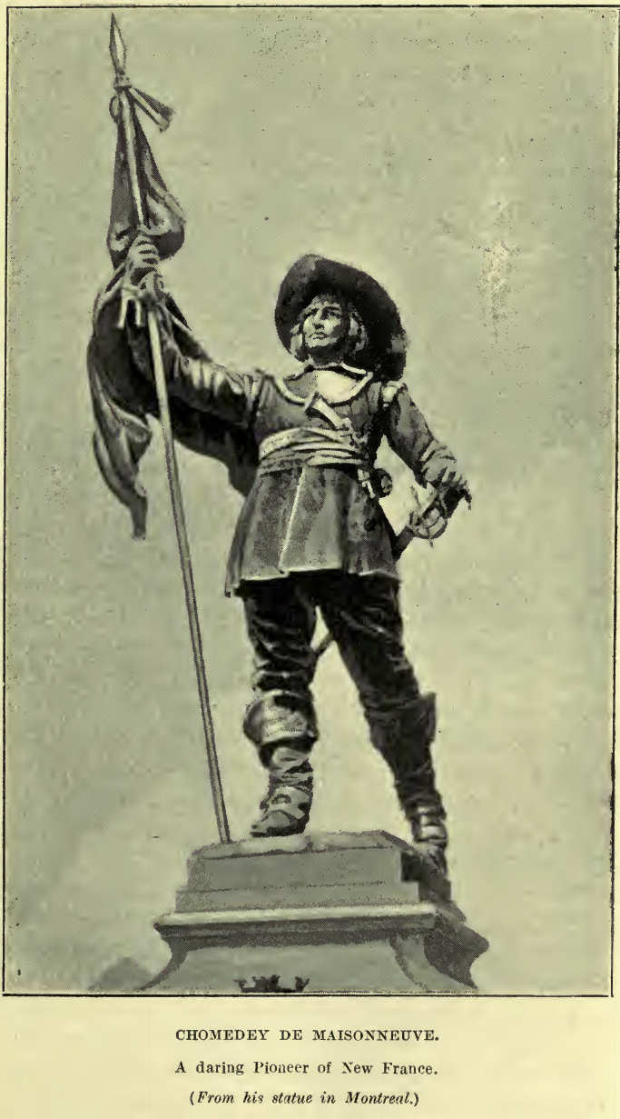
the single name of Verendrye.
This great explorer was born in Three Rivers, the
son of an old officer of the French army. The young cadet found very
little to do in the New World, and made his way home to France. He
served as a French officer in the War of the Spanish Succession, and
was severely wounded in the battle of Malplaquet. On his recovery, he
did not receive the recognition that he desired, and so went to the
western wilds of Canada and took up the life of a "coureur de bois."
Verendrye, in pursuing the fur trade, had
followed the somewhat deserted course which Radisson and Groseilliers
had long before taken, and which a decade before this La Noue had, as
we have seen, selected. The fort on Lake Nepigon was still the
rendezvous of the savages from the interior, who were willing to be
turned aside from visiting the English on Hudson Bay. From the Indians
who assembled around his fort on Lake Nepigon, in 1728, Verendrye
heard of the vast interior, and had some hopes of reaching the goal of
those who dreamt of a Western Sea.
An experienced Indian leader named Ochagach
undertook to map out on birch bark the route by which the lakes of the
interior could be reached, and the savage descanted with rapture upon
the furs to be obtained if the journey could be made. Verendrye,
filled with the thought of western discovery, went to Quebec, and
discussed his purpose with the Governor there. He pointed out the
route by way of the river of the Assiniboels, and then the rivers by
which Lake Ouinipegon might bo reached. His estimate was that the
Western Sea might be gained by an inland journey from Lake Superior of
500 leagues.
Governor Beauharnois considered the map submitted
and the opinions of Verendrye with his military engineer, Chaussegros
Do Lory; and their conclusions were favourable to Verendrye's
deductions. Verendrye had the manner and character which inspired
belief in his honesty and competence. He was also helped in his
dealings with the Governor at Quebec by the representations of Father
Gonor, whom we have seen had returned from the fort established among
the Sioux, convinced that the other route was impracticable.
Father Gonor entirely sympathized with Verendrye
in the belief that the only hope lay in passing through the country of
the Christinos and Assiniboels of the North. The Governor granted the
explorer the privilege of the entire profit of the fur trade, but was
unable to give any assistance in money. Verendrye now obtained the aid
of a number of merchants in Montreal in providing goods and equipment
for the journey, and in high glee journeyed westward, calling at
Michili-mackinac to take with him the Jesuit Father Messager, to be
the companion of his voyage. Near the end of August, 1731, the
expedition was at Pigeon River, long known as Grand Portage, a point
more than forty miles south-westward of the mouth of the
Kaministiquia.
This was a notable event in history when
Verendrye and his crew stood ready to face the hardships of a journey
to the interior. No doubt the way was hard and long, and the men were
sulky and discouraged, but the heroism of their commander shone forth
as he saw into the future and led the way to a vast and important
region.
Often since that time have important expeditions
going to the North-West been seen as they swept by the towering
heights of Thunder Cape, and, passing onward, entered the uninviting
mouth of Kaministiquia.
Eighty-five years afterward, Lord Selkirk and his
band of one hundred De Meuron soldiers appeared here in canoes and
penetrated to Red River to regain the lost Fort Douglas.
One hundred and twenty-six years after Verendrye,
according to an account given by an eye-witness—an old Hudson's Bay
Company officer—a Canadian steamer laden high above the decks appeared
at the mouth of the Kaministiquia, bearing the Dawson and Hind
expedition, to explore the plains of Assiniboia and pave the way for
their admission to Canada.
One hundred and thirty-nine years after
Verendrye, Sir Garnet Wolseley, with his British regulars and Canadian
volunteers, swept through Thunder Bay on their way to put down the Red
River rebellion.
And now one hundred and sixty-nine years after
Verendrye, the splendid steamers of the Canadian Pacific Railway
Company thrice a week in summer carry their living cargo into the
mouth of the Kaministiquia to be transported by rail to the fast
filling prairies of the West.
Yes! it was a great event when Verendrye and his
little band of unwilling voyageurs started inland from the shore of
Lake Superior.
Verendrye, his valiant nephew, Do La Jemeraye,
and his two sons, were the leaders of the expedition. Grand Portage
avoids by a nine mile portage the falls and rapids at the mouth of the
Pigeon River, and northward from this point the party went, and after
many hardships reached Rainy Lake in the first season, 1731. Here, at
the head of Rainy River, just where it leaves the Lake, they built
their first fort, St. Pierre. The writer has examined the site of this
fort, just three miles above the falls of Rainy River, and seen the
mounds and excavations still remaining. This seems to have been their
furthest point reached in the first season, and they returned to
winter at Kaministiquia. In the next year the expedition started
inland, and in the month of June reached their Fort St. Pierre,
descended the Rainy River, and with exultation saw the expanse of the
Lake of the Woods.
The earliest name wo find this lake known by is
that given by Verendrye. He says it was called Lake Minitio (Cree,
Ministik) or Des Bois. (1) The former of these names, Minitie, seems
to be Ojibway, and to mean Lake of the Islands, probably referring to
the largo number of islands to be found in the northern half of the
Lake. The other name (2), Lac des Bois, or Lake of the Woods, would
appear to have been a mistranslation of the Indian (Ojibway) name by
which the Lake was known. The name (3) was "Pikwcdina Sagaigan,"
meaning "the inland lake of the sand hills." referring to the skirting
range of sand hills running for some thirteen miles along the southern
shore of the Lake to the east of the mouth of Rainy River, its chief
tributary.
Another name found on a map prepared by the
Hudson's Bay Company in 1748 is (4) Lake Nimigon, probably meaning the
"expanse," referring to the open sheet of water now often called "La
Traverse." Two other names, (5) Clearwater Lake and (6) Whitefish
Lake, are clearly the extension of Clearwater Bay, a north-western
part of the Lake, and Whitefish Bay, still given by the Indians to the
channel to the east of Grande Presqu'ile.
On the south-west side of the Lake of the Woods
Verendrye's party built Fort St. Charles, probably hoping then to come
in touch with the Sioux who visited that side of the lake, and with
whom they would seek trade. At this point the prospect was very remote
of reaching the Western Sea. The expenses were great, and the fur
trade did not so far give sufficient return to justify a further march
to the interior. Unassisted they had reached in 1733 Lake Ouinipegon
(Winnipeg), by descending the rapid river from Lake of the Woods, to
which they gave the name of Maurepas.
The government in Quebec informed the French
Minister, M. de Maurepas, that they had been told by the adventurous
Jemeraye that if the French King would bear the expense, they were now
certain that the Western Sea could be reached. They had lost in going
to Lake Ouinipegon not less than 43,000 livres, and could not proceed
further without aid. The reply from the Court of France was
unfavourable; nothing more than the free privilege of the fur trade
was granted the explorers.
In the following year Verendrye built a fort near
Lake Ouinipegon, at the mouth of the Maurepas River (which we now know
as Winnipeg River), and not far from the present Fort Alexander. The
fort was called Fort Maurepas, although the explorers felt that they
had little for which to thank the French Minister. Still anxious to
push on further west, but prevented by want of means, they made a
second appeal to the French Government in 1735. But again came the
same reply of refusal. The explorers spent their time trading with the
Indians between Lake Winnipeg and Grand Portage, and coming and going,
as they had occasion, to Lake Superior, and also to Michilimackinac
with their cargoes.
While at Fort St. Charles, on the shores of the
Lake of the Woods, in 1736, a great disaster overtook the party.
Veren-drye's eldest son was very anxious to return to Kaministiquia,
as was also the Jesuit priest, Anneau, who was in company with the
traders. Verendrye was unwilling, but at last consented. The party,
consisting of the younger Verendrye and twenty men, were ruthlessly
massacred by an ambush of the Sioux on a small island some five
leagues from Fort St. Charles, still known as Massacre Island.
A few days afterwards the crime was discovered,
and Verendrye had difficulty in preventing his party from accepting
the offer of the Assiniboines and Christinos to follow the Sioux and
wreak their vengeance upon them. During the next year Fort Maurepas
was still their farthest outpost.
The ruins of Fort St. Charles on the south side
of the north-west angle of the Lake of the Woods were in 1908
discovered by St. Boniface Historical Society and the remains of young
Verendrye's party found buried in the ruins of the chapel.
Though no assistance could be obtained from the
French Court for western discovery, and although the difficulties
seemed almost insurmountable, Verendrye was unwilling to give up the
path open to him. He had the true spirit of the explorer, and chafed
in his little stockade on the shores of Lake Winnipeg, seeking new
worlds to conquer.
If it was a great event when Verendrye, in 1731,
left the shores of Lake Superior to go inland, it was one of equal
moment when, penniless and in debt, he determined at all hazards to
leave the rocks and woods of Lake Winnipeg, and seek the broad
prairies of the West. His decision being thus reached, the region
which is now the fertile Canadian prairies was entered upon.
Wo are fortunate in having the original Journal
of this notable expedition of 1738, obtained by Mr. Douglas Brymner,
former Archivist at Ottowa. This, with two letters of Bienville, were
obtained by Mr. Brymner from a French family in Montreal, and the
identity of the documents has been fully established.
This Journal covers the time from the departure
of Verendrye from Michilimackinac on July 20th, till say 1739, when he
writes from the heart of the prairies. On September 22nd the brave
Verendrye left Fort Maurepas for the land unknown. It took him but two
days with his five men to cross in swift canoes the south-east expanse
of Lake Winnipeg, enter the mouth of Red River, and reach the forks of
the Red and Assiniboine Rivers, where the city of Winnipeg now stands.
It was thus on September 24th of that memorable
year that the eyes of the white man first fell on the site of what is
destined to be the great central city of Canada. A few Crees who
expected him met the French explorer there, and he had a conference
with two chiefs, who were in the habit of taking their furs to the
English on Hudson Bay.
The water of the Assiniboine River ran at this
time very low, but Verendrye was anxious to push westward. Delayed by
the shallowness of the Assiniboine, the explorer's progress was very
slow, but in six days he reached the portage, then used to cross to
Lake Manitoba on the route to Hudson Bay. On this portage now stands
the town of Portage la Prairie.
The Assiniboine Indians who met Verendrye here
told him it would be useless for him to ascend the Assiniboine River
further, as the water was so low. Verendrye was expecting a
reinforcement to join his party, under his colleague, M. de la Marque.
He determined to remain at Portage la Prairie and to build a fort.
Verendrye then assembled the Indians, gave them presents of powder,
ball, tobacco, axes, knives, &c, and in the name of the French King
received them as the children of the great monarch across the sea, and
repeated several times to them the orders of the King they were to
obey.
It is very interesting to notice the skill with
which the early French explorers dealt with the Indians, and to see
the formal way in which they took possession of the lands visited.
Verendrye states that the Indians were greatly impressed, "many with
tears in their eyes." He adds with some naivete "They thanked me
greatly, promising to do wonders."
On October 3rd, Verendrye decided to build a
fort. He was joined shortly after by Messrs. de la Marque and Nolant
with eight men in two canoes. The fort was soon pushed on, and, with
the help of the Indians, was finished by October 15th. This was the
beginning of Fort de la Reine. At this stage in his journal Verendrye
makes an important announcement, bearing on a subject which has been
somewhat discussed.
Verendrye says, "M. de la Marque told me he had
brought M. de Louviere to the forks with two canoes to build a fort
there for the accommodation of the people of the Red River. I approved
of it if the Indians were notified." This settles the fact that there
was a fort at the forks of the Red and Assiniboine Rivers, and that it
was built in 1738.
In the absence of this information, we have been
in the habit of fixing the building of Fort Rouge at this point from
1735 to 1737. There can now be no doubt that October, 1738, is the
correct date. From French maps, as has been pointed out, Fort Rouge
stood at the mouth of the Assiniboine, on the south side of the river,
and the portion of the city of Winnipeg called Fort Rouge is properly
named.
It is, of course, evident that the forts erected
by these early explorers were simply winter stations, thrown up in
great haste.
Verendrye and his band of fifty-two persons,
Frenchmen and Indians, set out overland by the Mandan road on October
18th, to roach the Mandan settlements of the Missouri. It is not a
part of our work to describe that journey. Suffice it to say that on
December 3rd he was at the central fort of the Mandans, 250 miles from
his fort at Portage la Prairie.
Being unable to induce his Assiniboine guides and
interpreters to remain for the winter among the Mandans, Verendrye
returned somewhat unwillingly to the Assiniboine River. He arrived on
February 10th at his Fort de la Reine, as he says himself, "greatly
fatigued and very ill."
Verendrye in his journal gives us an excellent
opportunity of seeing the thorough devotion of the man to his duty.
From Fort Michilimackinac to the Missouri, by the route followed by
him, is not less than 1,200 miles, and this he accomplished, as we
have seen with the necessary delay of building a fort, between July
20th and December 3rd—136 days—of this wonderful year of 1738.
Struggling with difficulties, satisfying
creditors, hoping for assistance from France, but ever patriotic and
single-minded, Verendrye became the leading spirit in Western
exploration. In the year after his great expedition to the prairies,
he was summoned to Montreal to resist a lawsuit brought against him.
The prevailing sin of French Canada was jealousy. Though Verendrye had
struggled so bravely to explore the country, there were those who
whispered in the ear of the Minister of the French Court that he was
selfish and unworthy. In his heart-broken reply to the charges, he
says, "If more than 40,000 livres of debt which I have on my shoulders
are an advantage, then I can flatter myself that I am very rich."
In 1741 a fruitless attempt was made to reach the Mandans, but in the
following year Verendrye's eldest surviving son and his brother, known
as the Chevalier, having with them only two Canadians, loft Forte de
la Reine, and made in this and the succeeding year one of the most
famous of the Verendrye discoveries. This lies beyond the field of our
inquiry, being the journey to the Missouri, and up to an eastern spur
of the Rocky Mountains. Parkman, in his "A Half Century of Conflict,"
has given a detailed account of this remarkable journey.
Going northward over the Portage la Prairie,
Verendrye's sons had discovered what is now known as Lake Manitoba,
and had reached the Saskatchewan River. On the west side of Lake
Manitoba they founded Fort Dauphin, while at the west end of the
enlargement of the Saskatchewan known as Cedar Lake, they built Fort
Bourbon and ascended the Saskatchewan to the forks, which were known
as the Poskoiac.
Tardy recognition of Verendrye's achievements
came from the French Court in the explorer being promoted to the
position of captain in the Colonial troops, and a short time after he
was given the Cross of the Order of St. Louis. Beauharnois and his
successor Galissioniere had both stood by Verendrye and done their
best for him. Indeed, the explorer was just about to proceed on the
great expedition which was to fulfil their hopes of finding the
Western Sea, when, on December 6th, he passed away, his dream
unrealized. He was an unselfish soul, a man of great executive
ability, and one who dearly loved his King and country. He stands out
in striking contrast to the Bigots and Jonquieres, who disgraced the
name of France in the New World.
From the hands of these vampires, who had come to
suck out the blood of New France, Verendrye's sons received no
consideration. Their claims were coolly passed by, their goods
shamelessly seized, and their written and forcible re-monstrance made
no impression. Legardeur de St. Pierre, more to the mind of the
selfish Bigot, was given their place and property, and in 1751 a small
fort was built on the upper waters of the Saskatchewan, near the Rocky
Mountains, near where the town of Calgary now stands. This was called
in honour of the Governor, Fort La Jonquiere. A year afterward, St.
Pierre, with his little garrison of five men, disgusted with the
country, deserted Fort La Reine, which, a few weeks after, was burned
to the ground by the Assiniboines.
The fur trade was continued by the French in much
the same bounds, so long as the country remained in the hands of
France.
We are fortunate in having an account of these
affairs given in De Bougainville's Memoir, two years before the
capture of Canada by Wolfe. The forts built by Verendrye's successors
were included under the "Post of the Western Sea" (La Mer de l'Ouest).
Bougainville says, "The Post of the Western Sea is the most advanced
toward the north; it is situated amidst many Indian tribes, with whom
we trade and who have intercourse with the English, toward Hudson Bay.
We have there several forts built of stockades, trusted generally to
the care of one or two officers, seven or eight soldiers, and eighty
engages Canadians. We can push further the discoveries we have made in
that country, and communicate even with California."
This would have realized the dream of Verendrye
of reaching the Western Sea.
"The Post of La Mer de l'Ouest includes the forts
of St. Pierre, St. Charles, Bourbon, De la Reine, Dauphin, Poskoiac,
and Des Prairies (De la Jonquiere), all of which are built with
palisades that can give protection only against the Indians."
"The post of La Mer de l'Ouest merits special
attention for two reasons : the first, that it is the nearest to the
establishments of the English on Hudson Bay, and from which their
movements can be watched; the second, that from this post, the
discovery of the Western Sea may be accomplished; but to make this
discovery it will be necessary that the travellers give up all view of
personal interest."
Two years later, French power in North America
came to an end, and a generation afterward, the Western Sea was
discovered by British fur traders.