|
No sooner were the Highland
roads and bridges in full progress, than attention was directed to the
improvement of the harbours round the coast. Very little had as yet been
done for them beyond what nature had effected. Happily, there was a public
fund at disposal--the accumulation of rents and profits derived from the
estates forfeited at the rebellion of 1745--which was available for the
purpose. The suppression of the rebellion did good in many ways. It broke
the feudal spirit, which lingered in the Highlands long after it had ceased
in every other part of Britain; it led to the effectual opening up of the
country by a system of good roads; and now the accumulated rents of the
defeated Jacobite chiefs were about to be applied to the improvement of the
Highland harbours for the benefit of the general population.
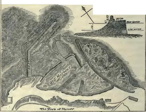
The harbour of Wick was one
of the first to which Mr. Telford's attention was directed. Mr. Rennie had
reported on the subject of its improvement as early as the year 1793, but
his plans were not adopted because their execution was beyond the means of
the locality at that time. The place had now, however, become of
considerable importance. It was largely frequented by Dutch fishermen during
the herring season; and it was hoped that, if they could be induced to form
a settlement at the place, their example might exercise a beneficial
influence upon the population.
Mr. Telford reported that, by
the expenditure of about 5890L., a capacious and well-protected tidal basin
might be formed, capable of containing about two hundred herring-busses. The
Commission adopted his plan, and voted the requisite funds for carrying out
the works, which were begun in 1808. The new station was named Pulteney
Town, in compliment to Sir William Pulteney, the Governor of the Fishery
Society; and the harbour was built at a cost of about 12,000L., of which
8500L. was granted from the Forfeited Estates Fund. A handsome stone bridge,
erected over the River Wick in 1805, after the design of our engineer,
connect's these improvements with the older town: it is formed of three
arches, having a clear waterway of 156 feet.
The money was well expended,
as the result proved; and Wick is now, we believe, the greatest fishing
station in the world. The place has increased from a little poverty-stricken
village to a large and thriving town, which swarms during the fishing season
with lowland Scotchmen, fair Northmen, broad-built Dutchmen, and kilted
Highlanders. The bay is at that time frequented by upwards of a thousand
fishing-boats and the take of herrings in some years amounts to more than a
hundred thousand barrels. The harbour has of late years been considerably
improved to meet the growing requirements of the herring trade, the
principal additions having been carried out, in 1823, by Mr. Bremner,*[1] a
native engineer of great ability.
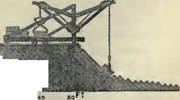
Folkestone Harbour.
Improvements of a similar
kind were carried out by the Fishery Board at other parts of the coast, and
many snug and convenient harbours were provided at the principal fishing
stations in the Highlands and Western Islands. Where the local proprietors
were themselves found expending money in carrying out piers and harbours,
the Board assisted them with grants to enable the works to be constructed in
the most substantial manner and after the most approved plans. Thus, along
that part of the bold northern coast of the mainland of Scotland which
projects into the German Ocean, many old harbours were improved or new ones
constructed--as at Peterhead, Frazerburgh, Banff, Cullen, Burgh Head, and
Nairn. At Fortrose, in the Murray Frith; at Dingwall, in the Cromarty Frith;
at Portmaholmac, within Tarbet Ness, the remarkable headland of the Frith of
Dornoch; at Kirkwall, the principal town and place of resort in the Orkney
Islands, so well known from Sir Walter Scott's description of it in the
'Pirate;' at Tobermory, in the island of Mull; and at other points of the
coast, piers were erected and other improvements carried out to suit the
convenience of the growing traffic and trade of the country.
The principal works were
those connected with the harbours situated upon the line of coast extending
from the harbour of Peterhead, in the county of Aberdeen, round to the head
of the Murray Frith. The shores there are exposed to the full force of the
seas rolling in from the Northern Ocean; and safe harbours were especially
needed for the protection of the shipping passing from north to south.
Wrecks had become increasingly frequent, and harbours of refuge were loudly
called for. At one part of the coast, as many as thirty wrecks had occurred
within a very short time, chiefly for want of shelter.
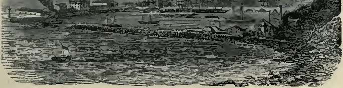
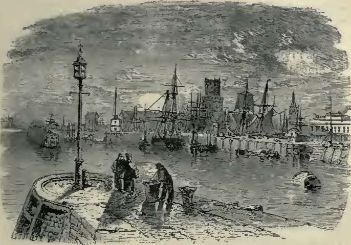
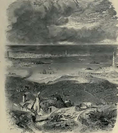
The situation of Peterhead
peculiarly well adapted it for a haven of refuge, and the improvement of the
port was early regarded as a matter of national importance. Not far from it,
on the south, are the famous Bullars or Boilers of Buchan--bold rugged
rocks, some 200 feet high, against which the sea beats with great fury,
boiling and churning in the deep caves and recesses with which they are
perforated. Peterhead stands on the most easterly part of the mainland of
Scotland, occupying the north-east side of the bay, and being connected with
the country on the northwest by an isthmus only 800 yards broad. In
Cromwell's time, the port possessed only twenty tons of boat tonnage, and
its only harbour was a small basin dug out of the rock. Even down to the
close of the sixteenth century the place was but an insignificant fishing
village. It is now a town bustling with trade, having long been the
principal seat of the whale fishery, 1500 men of the port being engaged in
that pursuit alone; and it sends out ships of its own building to all parts
of the world, its handsome and commodious harbours being accessible at all
winds to vessels of almost the largest burden.
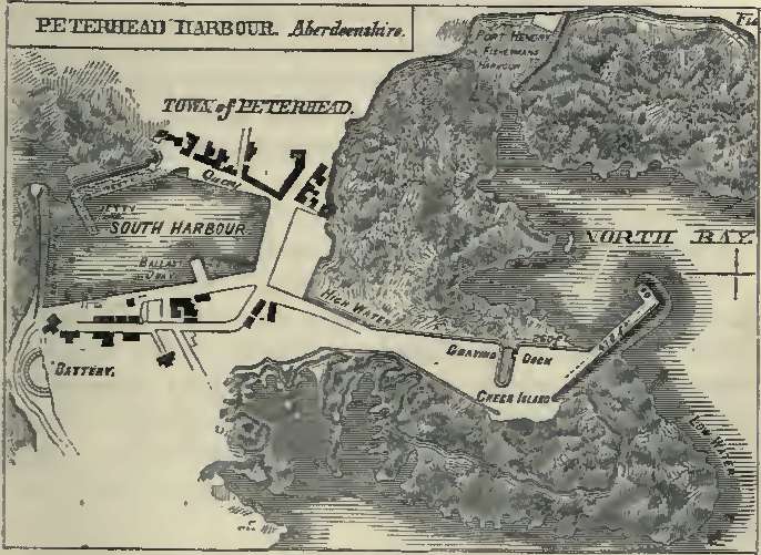
Peterhead
It may be mentioned that
about sixty years since, the port was formed by the island called Keith
Island, situated a small distance eastward from the shore, between which and
the mainland an arm of the sea formerly passed. A causeway had, however,
been formed across this channel, thus dividing it into two small bays; after
which the southern one had been converted in to a harbour by means of two
rude piers erected along either side of it. The north inlet remained without
any pier, and being very inconvenient and exposed to the north-easterly
winds, it was little used.
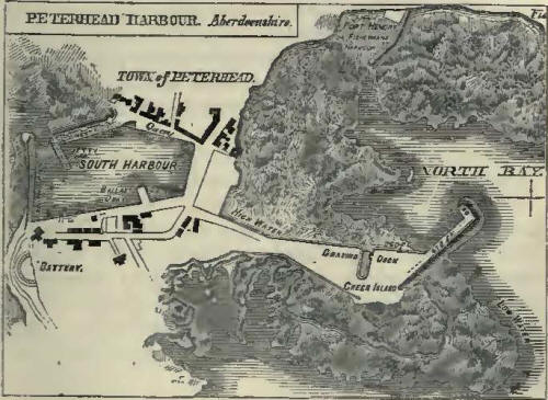
Peterhead Harbour.
The first works carried out
at Peterhead were of a comparatively limited character, the old piers of the
south harbour having been built by Smeaton; but improvements proceeded apace
with the enterprise and wealth of the inhabitants. Mr. Rennie, and after him
Mr. Telford, fully reported as to the capabilities of the port and the best
means of improving it. Mr. Rennie recommended the deepening of the south
harbour and the extension of the jetty of the west pier, at the same time
cutting off all projections of rock from Keith Island on the eastward, so as
to render the access more easy. The harbour, when thus finished, would, he
estimated, give about 17 feet depth at high water of spring tides. He also
proposed to open a communication across the causeway between the north and
south harbours, and form a wet dock between them, 580 feet long and 225 feet
wide, the water being kept in by gates at each end. He further proposed to
provide an entirely new harbour, by constructing two extensive piers for the
effectual protection of the northern part of the channel, running out one
from a rock north of the Green Island, about 680 feet long, and another from
the Roan Head, 450 feet long, leaving an opening between them of 70 yards.
This comprehensive plan unhappily could not be carried out at the time for
want of funds; but it may be said to have formed the groundwork of all that
has been subsequently done for the improvement of the port of Peterhead.
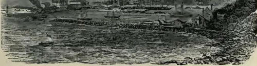
It was resolved, in the first
place, to commence operations by improving the south harbour, and protecting
it more effectually from south-easterly winds. The bottom of the harbour was
accordingly deepened by cutting out 30,000 cubic yards of rocky ground; and
part of Mr. Rennie's design was carried out by extending the jetty of the
west pier, though only for a distance of twenty yards. These works were
executed under Mr. Telford's directions; they were completed by the end of
the year 1811, and proved to be of great public convenience.
The trade of the town,
however, so much increased, and the port was found of such importance as a
place of refuge for vessels frequenting the north seas, that in 1816 it was
determined to proceed with the formation of a harbour on the northern part
of the old channel; and the inhabitants having agreed among themselves to
contribute to the extent of 10,000L. towards carrying out the necessary
works, they applied for the grant of a like sum from the Forfeited Estates
Fund, which was eventually voted for the purpose. The plan adopted was on a
more limited scale than that Proposed by Mr. Rennie; but in the same
direction and contrived with the same object,--so that, when completed,
vessels of the largest burden employed in the Greenland fishery might be
able to enter one or other of the two harbours and find safe shelter, from
whatever quarter the wind might blow.
The works were vigorously
proceeded with, and had made considerable progress, when, in October, 1819,
a violent hurricane from the north-east, which raged along the coast for
several days, and inflicted heavy damage on many of the northern harbours,
destroyed a large part of the unfinished masonry and hurled the heaviest
blocks into the sea, tossing them about as if they had been pebbles. The
finished work had, however, stood well, and the foundations of the piers
under low water were ascertained to have remained comparatively uninjured.
There was no help for it but to repair the damaged work, though it involved
a heavy additional cost, one-half of which was borne by the Forfeited
Estates Fund and the remainder by the inhabitants. Increased strength was
also given to the more exposed parts of the pierwork, and the slope at the
sea side of the breakwater was considerably extended.*[2] Those alterations
in the design were carried out, together with a spacious graving-dock, as
shown in the preceding plan, and they proved completely successful, enabling
Peterhead to offer an amount of accommodation for shipping of a more
effectual kind than was at that time to be met with along the whole eastern
coast of Scotland.
The old harbour of
Frazerburgh, situated on a projecting point of the coast at the foot of
Mount Kennaird, about twenty miles north of Peterhead, had become so ruinous
that vessels lying within it received almost as little shelter as if they
had been exposed in the open sea. Mr. Rennie had prepared a plan for its
improvement by running out a substantial north-eastern pier; and this was
eventually carried out by Mr. Telford in a modified form, proving of
substantial service to the trade of the port. Since then a large and
commodious new harbour has been formed at the place, partly at the public
expense and partly at that of the inhabitants, rendering Frazerburgh a safe
retreat for vessels of war as well as merchantmen.
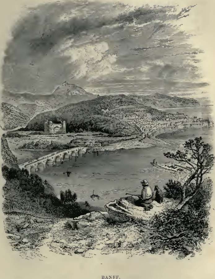
Banff.
Among the other important
harbour works on the northeast coast carried out by Mr. Telford under the
Commissioners appointed to administer the funds of the Forfeited Estates,
were those at Banff, the execution of which extended over many years; but,
though costly, they did not prove of anything like the same convenience as
those executed at Peterhead. The old harbour at the end of the ridge running
north and south, on which what is called the "sea town" of Banff is
situated, was completed in 1775, when the place was already considered of
some importance as a fishing station.
Banff Harbour.
This harbour occupies the
triangular space at the north-eastern extremity of the projecting point of
land, at the opposite side of which, fronting the north-west, is the little
town and harbour of Macduff. In 1816, Mr. Telford furnished the plan of a
new pier and breakwater, covering the old entrance, which presented an
opening to the N.N.E., with a basin occupying the intermediate space. The
inhabitants agreed to defray one half of the necessary cost, and the
Commissioners the other; and the plans having been approved, the works were
commenced in 1818. They were in full progress when, unhappily, the same
hurricane which in 1819 did so much injury to the works at Peterhead, also
fell upon those at Banff, and carried away a large part of the unfinished
pier. This accident had the effect of interrupting the work, as well as
increasing its cost; but the whole was successfully completed by the year
1822. Although the new harbour did not prove very safe, and exhibited a
tendency to become silted up with sand, it proved of use in many respects,
more particularly in preventing all swell and agitation in the old harbour,
which was thereby rendered the safest artificial haven in the Murray Firth.
It is unnecessary to specify
the alterations and improvements of a similar character, adapted to the
respective localities, which were carried out by our engineer at Burgh Head,
Nairn, Kirkwall, Tarbet, Tobermory, Portmaholmac, Dingwall (with its canal
two thousand yards long, connecting the town in a complete manner with the
Frith of Cromarty), Cullen, Fortrose, Ballintraed, Portree, Jura, Gourdon,
Invergordon, and other places. Down to the year 1823, the Commissioners had
expended 108,530L. on the improvements of these several ports, in aid of the
local contributions of the inhabitants and adjoining proprietors to a
considerably greater extent; the result of which was a great increase in the
shipping accommodation of the coast towns, to the benefit of the local
population, and of ship-owners and navigators generally.
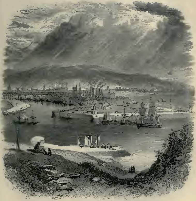
Mr. Telford's principal
harbour works in Scotland, however, were those of Aberdeen and Dundee,
which, next to Leith (the port of Edinburgh), formed the principal havens
along the east coast. The neighbourhood of Aberdeen was originally so wild
and barren that Telford expressed his surprise that any class of men should
ever have settled there. An immense shoulder of the Grampian mountains
extends down to the sea-coast, where it terminates in a bold, rude
promontory. The country on either side of the Dee, which flows past the
town, was originally covered with innumerable granite blocks; one, called
Craig Metellan, lying right in the river's mouth, and forming, with the
sand, an almost effectual bar to its navigation. Although, in ancient times,
a little cultivable land lay immediately outside the town, the region beyond
was as sterile as it is possible for land to be in such a latitude. "Any
wher," says an ancient writer, "after yow pass a myll without the tonne, the
countrey is barren lyke, the hills craigy, the plaines full of marishes and
mosses, the feilds are covered with heather or peeble stons, the come feilds
mixt with thes bot few. The air is temperat and healthful about it, and it
may be that the citizens owe the acuteness of their wits thereunto and their
civill inclinations; the lyke not easie to be found under northerlie climats,
damped for the most pairt with air of a grosse consistence."*[3] But the old
inhabitants of Aberdeen and its neighbourhood were really as rough as their
soil. Judged by their records, they must have been dreadfully haunted by
witches and sorcerers down to a comparatively recent period; witch-burning
having been common in the town until the end of the sixteenth century. We
find that, in one year, no fewer than twenty-three women and one man were
burnt; the Dean of Guild Records containing the detailed accounts of the
"loads of peattis, tar barrellis," and other combustibles used in burning
them. The lairds of the Garioch, a district in the immediate neighbourhood,
seem to have been still more terrible than the witches, being accustomed to
enter the place and make an onslaught upon the citizens, according as local
rage and thirst for spoil might incline them. On one of such occasions,
eighty of the inhabitants were killed and wounded.*[4] Down even to the
middle of last century the Aberdonian notions of personal liberty seem to
have been very restricted; for between 1740 and 1746 we find that persons of
both sexes were kidnapped, put on board ships, and despatched to the
American plantations, where they were sold for slaves. Strangest of all, the
men who carried on this slave trade were local dignitaries, one of them
being a town's baillie, another the town-clerk depute. Those kidnapped were
openly "driven in flocks through the town, like herds of sheep, under the
care of a keeper armed with a whip."*[5] So open was the traffic that the
public workhouse was used for their reception until the ships sailed, and
when that was filled, the tolbooth or common prison was made use of. The
vessels which sailed from the harbour for America in 1743 contained no fewer
than sixty-nine persons; and it is supposed that, in the six years during
which the Aberdeen slave trade was at its height, about six hundred were
transported for sale, very few of whom ever returned.*[6] This slave traffic
was doubtless stimulated by the foreign ships beginning to frequent the
port; for the inhabitants were industrious, and their plaiding, linen, and
worsted stockings were in much request as articles of merchandise. Cured
salmon were also exported in large quantities. As early as 1659, a quay was
formed along the Dee towards the village of Foot Dee. "Beyond Futty," says
an old writer, "lyes the fisher-boat heavne; and after that, towards the
promontorie called Sandenesse, ther is to be seen a grosse bulk of a
building, vaulted and flatted above (the Blockhous they call it), begun to
be builded anno 1513, for guarding the entree of the harboree from pirats
and algarads; and cannon wer planted ther for that purpose, or, at least,
that from thence the motions of pirats might be tymouslie foreseen. This
rough piece of work was finished anno 1542, in which yer lykewayes the mouth
of the river Dee was locked with cheans of iron and masts of ships crossing
the river, not to be opened bot at the citizens' pleasure."*[7] After the
Union, but more especially after the rebellion of 1745, the trade of
Aberdeen made considerable progress. Although Burns, in 1787, briefly
described the place as a "lazy toun," the inhabitants were displaying much
energy in carrying out improvements in their port.*[8] In 1775 the
foundation-stone of the new pier designed by Mr. Smeaton was laid with great
ceremony, and, the works proceeding to completion, a new pier, twelve
hundred feet long, terminating in a round head, was finished in less than
six years. The trade of the place was, however, as yet too small to justify
anything beyond a tidal harbour, and the engineer's views were limited to
that object. He found the river meandering over an irregular space about
five hundred yards in breadth; and he applied the only practicable remedy,
by confining the channel as much as the limited means placed at his disposal
enabled him to do, and directing the land floods so as to act upon and
diminish the bar. Opposite the north pier, on the south side of the river,
Smeaton constructed a breast-wall about half the length of the Pier. Owing,
however, to a departure from that engineer's plans, by which the pier was
placed too far to the north, it was found that a heavy swell entered the
harbour, and, to obviate this formidable inconvenience, a bulwark was
projected from it, so as to occupy about one third of the channel entrance.
The trade of the place
continuing to increase, Mr. Rennie was called upon, in 1797, to examine and
report upon the best means of improving the harbour, when he recommended the
construction of floating docks upon the sandy flats called Foot Dee. Nothing
was done at the time, as the scheme was very costly and considered beyond
the available means of the locality. But the magistrates kept the subject in
mind; and when Mr. Telford made his report on the best means of improving
the harbour in 1801, he intimated that the inhabitants were ready to
cooperate with the Government in rendering it capable of accommodating ships
of war, as far as their circumstances would permit.
In 1807, the south pier-head,
built by Smeaton, was destroyed by a storm, and the time had arrived when
something must be done, not only to improve but even to preserve the port.
The magistrates accordingly proceeded, in 1809, to rebuild the pier-head of
cut granite, and at the same time they applied to Parliament for authority
to carry out further improvements after the plan recommended by Mr. Telford;
and the necessary powers were conferred in the following year. The new works
comprehended a large extension of the wharfage accommodation, the
construction of floating and graving docks, increased means of scouring the
harbour and ensuring greater depth of water on the bar across the river's
mouth, and the provision of a navigable communication between the
Aberdeenshire Canal and the new harbour.
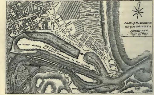
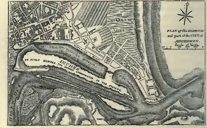
Plan of Aberdeen Harbour
The extension of the north
pier was first proceeded with, under the superintendence of John Gibb, the
resident engineer; and by the year 1811 the whole length of 300 additional
feet had been completed. The beneficial effects of this extension were so
apparent, that a general wish was expressed that it should be carried
further; and it was eventually determined to extend the pier 780 feet beyond
Smeaton's head, by which not only was much deeper water secured, but vessels
were better enabled to clear the Girdleness Point. This extension was
successfully carried out by the end of the year 1812. A strong breakwater,
about 800 feet long, was also run out from the south shore, leaving a space
of about 250 feet as an entrance, thereby giving greater protection to the
shipping in the harbour, while the contraction of the channel, by increasing
the "scour," tended to give a much greater depth of water on the bar.
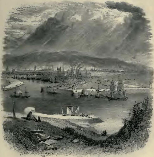
Aberdeen Harbour.
The outer head of the pier
was seriously injured by the heavy storms of the two succeeding winters,
which rendered it necessary to alter its formation to a very flat slope of
about five to one all round the head.*[9]
Section of pier-head work.
New wharves were at the same
time constructed inside the harbour; a new channel for the river was
excavated, which further enlarged the floating space and wharf
accommodation; wet and dry docks were added; until at length the quay
berthage amounted to not less than 6290 feet, or nearly a mile and a quarter
in length. By these combined improvements an additional extent of quay room
was obtained of about 4000 feet; an excellent tidal harbour was formed, in
which, at spring tides, the depth of water is about 15 feet; while on the
bar it was increased to about 19 feet. The prosperity of Aberdeen had
meanwhile been advancing apace. The city had been greatly beautified and
enlarged: shipbuilding had made rapid progress; Aberdeen clippers became
famous, and Aberdeen merchants carried on a trade with all parts of the
world; manufactures of wool, cotton, flax, and iron were carried on with
great success; its population rapidly increased; and, as a maritime city,
Aberdeen took rank as the third in Scotland, the tonnage entering the port
having increased from 50,000 tons in 1800 to about 300,000 in 1860.
Improvements of an equally
important character were carried out by Mr. Telford in the port of Dundee,
also situated on the east coast of Scotland, at the entrance to the Frith of
Tay. There are those still living at the place who remember its former
haven, consisting of a crooked wall, affording shelter to only a few
fishing-boats or smuggling vessels--its trade being then altogether paltry,
scarcely deserving the name, and its population not one fifth of what it now
is. Helped by its commodious and capacious harbour, it has become one of the
most populous and thriving towns on the east coast.
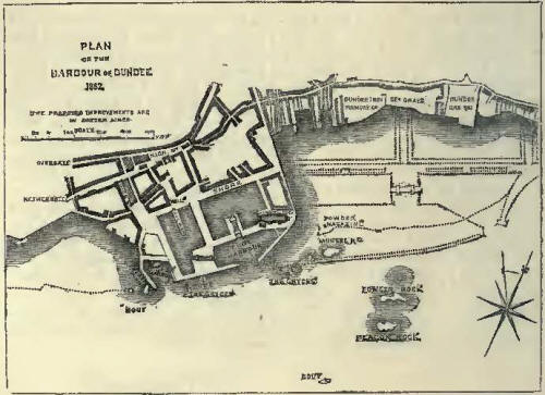
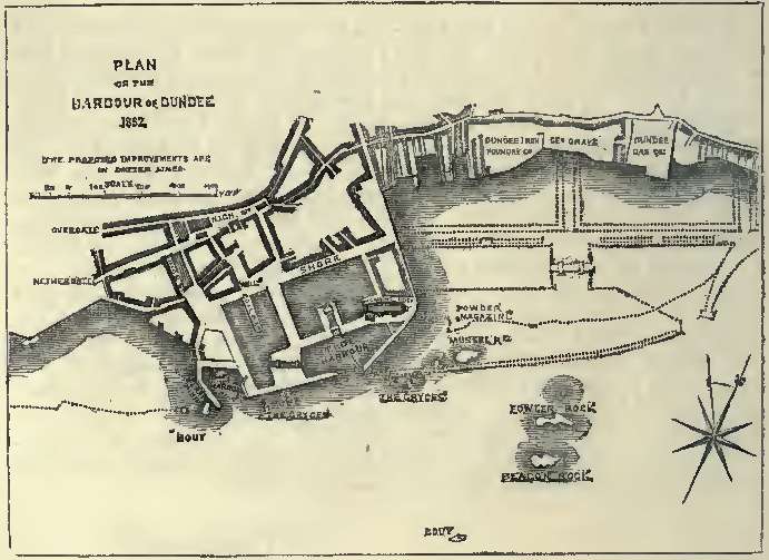
Plan of Dundee Harbour.
The trade of the place took a
great start forward at the close of the war, and Mr. Telford was called upon
to supply the plans of a new harbour. His first design, which he submitted
in 1814, was of a comparatively limited character; but it was greatly
enlarged during the progress of the works. Floating docks were added, as
well as graving docks for large vessels. The necessary powers were obtained
in 1815; the works proceeded vigorously under the Harbour Commissioners, who
superseded the old obstructive corporation; and in 1825 the splendid new
floating dock--750 feet long by 450 broad, having an entrance-lock 170 feet
long and 40 feet wide--was opened to the shipping of all countries.

Dundee Harbour.
Footnotes for Chapter IX.
*[1] Hugh Millar, in his 'Cruise of the Betsy,' attributes the invention of
columnar pier-work to Mr. Bremner, whom he terms "the Brindley of Scotland."
He has acquired great fame for his skill in raising sunken ships, having
warped the Great Britain steamer off the shores of Dundrum Bay. But we
believe Mr. Telford had adopted the practice of columnar pier-work before
Mr. Bremner, in forming the little harbour of Folkestone in 1808, where the
work is still to be seen quite perfect. The most solid mode of laying stone
on land is in flat courses; but in open pier work the reverse process is
adopted. The blocks are laid on end in columns, like upright beams jammed
together. Thus laid, the wave which dashes against them is broken, and
spends itself on the interstices; where as, if it struck the broad solid
blocks, the tendency would be to lift them from their beds and set the work
afloat; and in a furious storm such blocks would be driven about almost like
pebbles. The rebound from flat surfaces is also very heavy, and produces
violent commotion; where as these broken, upright, columnar-looking piers
seem to absorb the fury of the sea, and render its wildest waves
comparatively innocuous.
*[2] 'Memorials from
Peterhead and Banff, concerning Damage occasioned by a Storm.' Ordered by
the House of Commons to be printed, 5th July, 1820. [242.]
*[3] 'A Description of Bothe
Touns of Aberdeene.' By James Gordon, Parson of Rothiemay. Reprinted in
Gavin Turreff's 'Antiquarian Gleanings from Aberdeenshire Records.'
Aberdeen, 1889.
*[4] Robertson's 'Book of
Bon-Accord.'
*[5] Ibid., quoted in
Turreff's 'Antiquarian Gleanings,' p. 222.
*[6] One of them, however,
did return--Peter Williamson, a native of the town, sold for a slave in
Pennsylvania, "a rough, ragged, humle-headed, long, stowie, clever boy,"
who, reaching York, published an account of the infamous traffic, in a
pamphlet which excited extraordinary interest at the time, and met with a
rapid and extensive circulation. But his exposure of kidnapping gave very
great offence to the magistrates, who dragged him before their tribunal as
having "published a scurrilous and infamous libel on the corporation," and
he was sentenced to be imprisoned until he should sign a denial of the truth
of his statements. He brought an action against the corporation for their
proceedings, and obtained a verdict and damages; and he further proceeded
against Baillie Fordyce (one of his kidnappers, and others, from whom he
obtained 200L. damages, with costs. The system was thus effectually put a
stop to.
*[8] 'A Description of Bothe
Touns of Aberdeene.' By James Gordon, Parson of Rothiemay. Quoted by Turreff,
p. 109.
*[8] Communication with
London was as yet by no means frequent, and far from expeditious, as the
following advertisement of 1778 will show:--"For London: To sail positively
on Saturday next, the 7th November, wind and weather permitting, the
Aberdeen smack. Will lie a short time at London, and, if no convoy is
appointed, will sail under care of a fleet of colliers the best convoy of
any. For particulars apply," &c., &c.
*[9] "The bottom under the
foundations," says Mr. Gibb, in his description of the work, "is nothing
better than loose sand and gravel, constantly thrown up by the sea on that
stormy coast, so that it was necessary to consolidate the work under low
water by dropping large stones from lighters, and filling the interstices
with smaller ones, until it was brought within about a foot of the level of
low water, when the ashlar work was commenced; but in place of laying the
stones horizontally in their beds, each course was laid at an angle of 45
degrees, to within about 18 inches of the top, when a level coping was
added. This mode of building enabled the work to be carried on
expeditiously, and rendered it while in progress less liable to temporary
damage, likewise affording three points of bearing; for while the ashlar
walling was carrying up on both sides, the middle or body of the pier was
carried up at the same time by a careful backing throughout of large
rubble-stone, to within 18 inches of the top, when the whole was covered
with granite coping and paving 18 inches deep, with a cut granite parapet
wall on the north side of the whole length of the pier, thus protected for
the convenience of those who might have occasion to frequent it."--Mr.
Gibb's 'Narrative of Aberdeen Harbour Works.' |