|
Situation of the Town—Extent
of the Parish—Topography—Latitude and Longitude—Etymology of
Blairgowrie—Traditions—Description of the Town—Origin of Street
Names—Soil—Geology—Quarries—Fossils —Wood—Arboriculture—Piscatorial-
Zoology.
THE town of Blairgowrie is
situated at the base of that part of the southern range of the Grampian
Mountains eut by the River Ericht. On the left the valley and burn of Lornty
give a double breast to the hut. The heights to the north are the Heughs of
Mause, Knock-ma-har, and the Hill of Blair. On the east side of the river
are the “Cennetliy,” or the Hatton Hill, and the higher one
“Glower-ower-im,” possibly so termed because the spectator from its summit
can survey a huge tract of country. Behind Knock-ma-har is the valley of the
Lornty, and away further north, on the heights beyond, the Muir of Cocbrage
and Forest of Clunie. Immediately to the south of Blairgowrie is the famous
strath—the Howe of Strathmore—with its streams, and lakes, and woods, and
pastures.
As regards beauty of
situation and salubrity of climate the town enjoys peculiar advantages.
Situated on the banks of a pure and rapid river, on the confines of the
Highlands, it possesses the advantage of highly-picturesque and diversified
scenery, both highland and lowland. Sheltered by the wooded heights to the
north from the cold northern winds, snow seldom falls to any depth, and soon
melts from the southern slope on which the town is situated, while its
openness to the south, east, and west gives free circulation to the winds
from these directions.
Blairgowrie is situated
between north latitude 56 degs. 35 mins. 6 secs, and 50 degs. 35 mins. 44
secs., and between west longitude 3 degs. 20 mins. and 3 degs. 20 mins. 45
secs.
The extent of the parish of
Blairgowrie is about eleven miles from north to south, and about eight,
miles east and west, irregular in figure, and frequently intersected by the
parishes of Rattray, Kinloch, and Bendochy.
The town is situated at a
good altitude from the mean sea level at Liverpool, according to the data of
the Ordnance Survey of 1803. At the Beeches, west-end of town, the height in
feet is 264-5; Greenbank Engineering Works, 25S; Bankhead Toll, 229-75;
Bridge, of Blair, 197-75; foot of Allan Street, 216; Royal Hotel, 243; Bank
of Scotland, 245; First Free Church, 279-75; Parish Church, 331-62 ; and
Hill of Blair, 337-5.
Regarding the origin of
Blairgowrie and the derivation of the name there have been suggested many
definitions, but they are not very certain. The first half of the name may
be traced from the Celtic “Blair,” signifying a battlefield; the latter
part, how ever, “Gowri«,” is difficult to trace. One derivation, according
to the following tradition, if not certain, is at least plausible. The great
valley of Strathmore was, at one time, a vast forest in which the kings of
Scotland were wont to hunt. At intervals here and there in the forest were
considerable patches of ground or crofts cultivated by woodmen, in the pay
of the sovereign, to raise the crops necessary for the Court. These woodmen
had also, when called upon, to attend the King during the chase, and join
his bodyguard in the event of war. We are not informed who this royal
personage was, who, like the Gudeman o’ Balliugeich, used to disguise
himself in the chase so that he might better see the condition of his
people. On one of these occasions alone, save \\ ith an attendant and a pack
of hounds, the King had got separated from the rest of the party, and,
drawing near to one of the clearings from which they saw a column of smoke
ascend, heard the sound of music. A nearer approach revealed to their
astonished gaze the sprightly trippings of a lovely maiden dancing a reel to
the spirit-enlivening music of the pibroch played by an old piper. The maid,
not the least shy when she discovered the stranger gazing at her, told him
to “glower aye,” and the old piper, removing the chanter from his mouth,
invited him to join in. Nothing loath the stranger accepted the invitation,
perhaps not unwilling to be recognised. At the finish he politely asked the
maiden’s name, and with a captivating smile she muttered, though scarcely
audible, “Gow” Then the stranger, clasping her hand in his own, addressed
the old piper:—“Thy name is ‘ Gow ’ and I am ‘ Righ,' and now...
WELLMEADOW
“This muir shall be my
huntingtield;
This peasant hen my queen shall be;
Of twenty miles ye’ll get the yield;
An’ be the laird of ‘Gow-an-Rlgh.’”
Gow, a smith; Righ, a
king—Blairgowrie, the field of the king’s smith. Another derivation,
however, may be the more correct one. Blair\ a battlefield; and Goiurie, a
hollow or between the hills—the battlefield in the hollow, probably so
called from the Battle of Mons Grampius reputed to have been fought in the
valley between Knock-ma-har and the ridge along by the Heughs of Mause.
The town in its present state
takes the form of a square, and by its streets is formed into squares. The
streets are of the ordinary breadth, with side footways paved with asphalte,
granolithic, or gravel, and are kept very clean. In the north and western
districts of the town a small plot of ground in front of the houses gives a
healthy openness to the town, combined with seclusion.
In the disposition of its
principal thoroughfares, the old roads which formed the means of
communication with the neighbouring districts still form the main arteries
of the burgh. Dividing it into two almost equal divisions, the old turnpike
from Perth to Kirriemuir is still the main street, though termed in its
different sections Allan Street, High Street, and Perth Street. From the
south the turnpike from Coupar Angus intersects again, leading across
towards the north over the Hill of Blair. Of the numerous streets running
parallel south by west, the furthest south is Terminus Street. This has its
end to the west running into the Coupar Angus Road, and terminating at the
east in :Welton Road. This street bounds the Gas Works on the south and the
Railway Station on the north. The Station Buildings have within recent years
been entirely remodelled and reconstructed, and present a very handsome
appearance. Gas Brae bounds the Gas Works on the north, running from foot of
Reform Street to Wellmeadow. Leslie Street, -with continuation of Union
Street lies to the west. On the south side of Leslie Street is the North of
Scotland Bank, formerly Bleaton House; on the south side of Union Street is
the Volunteer Drill Ilall, opened 1898. High Street runs westwards, with
continuation of Perth Street and Perth Road. At the Cross—the site of the
old Mercate Cross of Blair—is the Royal Hotel, built on the site of a house
in which a former proprietor (Brown of Marlee) was born, as recorded by a
tablet over the entrance door. In the High Street are the Queen’s Hotel,
immediately opposite which stood John Tyrie’s brew-house; the Mechanics’
Institute and Working Men’s Club, erected in 1870 at a cost of £800; the
Bank of Scotland. On the south side of the street, nearly opposite the
Institute, stood a small house in which Prince Charlie is said to have
passed a night on his way to the south, and which was known long afterwards
as “The Palace.”
George Street, in the same
parallel, extends from Dunkeld Road on the west, alongside of the “Lochy,”
with access to Bowling Green, and terminating in James Street with a
two-branch way, the left leading to the First Free Church and the right to
Upper Allan Street, the Parish Church, Public Schools, and Hill of Blair.
Lochy Terrace, Emma Terrace,
and Newton Terrace are in a way of being opened up.
From the east end of the
Station the Welton Road, leading up the west side of the River Ericht,
enters the “ Tannage,” now known as Tannage Street, a tan work at one time
having been in operation there. Commercial Street, opened up in 1882 through
what used to be the garden of the Station Hotel, leads from the front
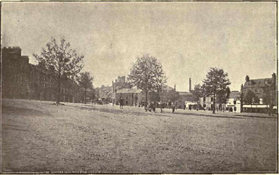
entrance of the Station Buildings to the Wellmeadow and heart of the town.
The north side of the Meadow is bounded by a handsome block known as the “
Bank Buildings,” containing principally a branch of the Union Bank, and the
Blairgow rie Arms and the Constitutional Club, erected on the site of what
was formerly Jackson’s Inn. Nearly opposite this building was St Ninian’s
Well, from which the square took its name—Wellmeadow— having its source in a
spring, led some years ago into the town drainage. In former times this area
was a marsh, and, having been improved and drained, was, within the memory
of some of our old worthies, a public park where the nomadic drover, and
shepherd pastured their flocks.
The square presents rather an
ornate appearance if only it was kept in better condition, a row of trees
having been planted round it over a dozen years ago, and which are thriving
luxuriantly. At the south-east corner is a memorial fountain, erected in
1893, to commemorate the life and work of the late Superior, Allan
Macpherson, Esq. of Blairgowrie. The fountain is of red stone, beautifully
carved and finished. On the south side of the Meadow are the Gas "Works,
erected in 1831; the Auction Mart and cattle sale stores; the Grown Inn and
Railw ay Hotel—a very busy rendezvous for fanners and dealers on market
days. On the east side are the Temperance Hotel and the Bridge of
Blairgowrie; the Ogilvy Anns; Victoria Hotel, built on the site of an old
hostelry; the Commercial Bank; and the intersection of Leslie and Allan
Streets. The latter (Allan Street) leads from the Meadow to the “Cross,”
with continuation of Upper Allan Street to Hill of Blair. Immediately to the
right are Blairgowrie Brewery, belonging to Messrs Ogilvy, and Upper Mill
Street leading to the Meal Mill, Ericht Linen Works, the old Plash Mill, and
to Oakbank up the river side; opposite is the Royal Bank, and Ericht Lane
leading west to the Croft. On the left of this street is a handsome block of
buildings which give some appearance. The site they occupy was in former
years held by a block considered, in its day, the best in town, but burned
down in 1890. Neai by stood also a public-house, and a bye-path leading
thereto was known as the “Whuskie Roadie.” On the other side of the street,
at “Davie’s Pend,” over 80 years ago stood the old “guard house” of Blair or
jail for the retention of prisoners; adjoining the gable, strung up between
two posts, was the “auld bell o’ Blair,” tolled on high days and market
days. The Croft connects west end of Wellmeadow with Leslie Street and High
Street, with continuation of Bank Street and David Street to Newton Terrace.
From the west end of Gas Brae, Reform Street leads up to Perth Street and is
set off on the left by the South Free Church, St Mary’s Parish Church,
Mission House, and “Advertiser” Office; an off-side continuation is John
Street, leading to the Roman Catholic School, formerly the old Parochial
School.
Further west is William
Street, running from Bankhead Toll to Perth Street, in which are South Free
Church School and Congregational Church. Jessie Street leads from Emma
Street to Perth Street. Side streets further ’west, but still unformed, are
Castle Street, opposite Lochy Street, leading to the Lochy aud Bowling
Green; Athole Street, opposite the intersection of the Dunkeld Road with
Perth Road. On the Dunkeld Road are the famous Agricultural Engineering
Works of Messrs Bisset & Sons, Limited. The west-end of Blairgowrie, from
Athole Street onwards out to Falcon House, is well laid out and enriched
with cottages and villas of the upper class. East of Lochy Street and
mid-way to John Street is Newton Street leading from Perth Street to
Maryfield. In this street are, for the most part, many fashionable and
desirable residences.
The Parsonage, Viewfield, The
Feu, and Newton Castle being most prominent. Newton Castle is an interesting
historical pile, and is frequently mentioned in history. It was sacked by
Oliver Cromwell and by Montrose; occupied by Royalist troops in 1745; was
the birth-place of George Drummond, six times Lord Provost of Edinburgh, and
founder of the Royal Infirmary (died 1766); and of Thomas Graham, the hero
of Barossa and Vittoria (Lord Lynedoch), died 1843.
Newton Terrace extends from
west-end of Gallowbank east to Upper Allan Street, and is for the most part
unformed though rather a pleasant promenade in summer.
Upper Allan Street leads from
the Cross, at Royal Hotel, northwards past the site of the earliest
Parochial School— the Parish Manse where it divides into two, that road to
the right, the Little Hill, leading to the Parish Church and Parish
Bui’3’ing-Grouud. The church was erected in 1824 on the public bowling green
of a former generation, and where the laird of Newton was massacred by his
neighbours in 1554. Almost adjoining are the Maltings of Mr William Panton,
who carries on an extensive business in this line. The road to the left, the
Hill, leads north, passing the Public Schools of Blairgowrie, erected in
1879 on part of the parish glebe, but used for many a year as “The toon's
park.”
This road joins on to the
Little Hill at Stormont Lodge, and leads northward over the Bridge at the “
Cuttle ” ravine to the “Board of Health,” Knocli-ma-har,
Lornty, and the Heughs of
Mause.
* * * * * *
The names of a few of the
principal streets throughout the town are derived thus:—“Allan Street,”
after Col. Allan Macpherson, Superior of the Burgh in 1800 ; “Brown Street”
and "John Street,” after John Brown of Marlee (born in a house on the site
of which the Royal Hotel now stands); “Bank Street,” formerly Constable
Lane, changed when the Bank of Scotland was built; “Leslie Street,” after
James Leslie, proprietor of the Leslie Feus; “James Street,” after James
Geddes, mason; “Keay Street,” after Miss Keay, a feuar there; “Mitchell
Square,” after Thomas Mitchell of Greenfield; “ Newton Lane ” and “Newton
Street,” as the lane and street leading to Newton Castle; “Chalmers Street,”
after Provost Chalmers; “George Street,” after George Drummond of Newton;
“Tannage Street,” from a tannery which existed there; “ Terminus Street,”
the terminus of the railway system ; “Mill Street,” as leading to the Mill,
&c.
Soil.
The alluvium which covers the
strata around Blairgowrie is a species of till of very irregular thickness
and quality.
At a place known as the
Heughs of Mause, a mile or so north of the town, it forms a precipice of a
very singular and picturesque appearance, rising from the bed of the river
to a height of over 200 feet.
To the north-west the grey
wacke formation is covered with moss, forming the great moss of Cochrage, an
extensive tract of barren moor covered with heath and marsh.
South of this, on the slopes
of the ridges rising to the north of the town, the soil is a stiff brown
clay of considerable fertility, and in the south of the parish, it is a
strong black loam intervened by the Muir of Blair, a large extent of barren,
unproductive. gravel, part under cultivation of strawberry and other fruits,
part under plantation, and the remainder covered with whins and heather.
Geology.
All the rocks in the parish
are of the conglomerate or sandstone formation.
About four miles north of the
town there is a quarry, now discontinued, of clay slate. This formation
seems to stretch across the parish in a south-westerly direction, but it is
not visible at any other point till it reappears at Forneth. Its thickness
is supposed to be about 40 feet.
A stratum of whinstone is
found along the summit of the ridge at the back of the town known as
Knock-ma-har. The strata is nearly horizontal, with a slight inclination to
the north-west. All along the southern slope entending into the lower ground
to the south and west, there is a very extensive stratum of coarse red
sandstone of great thickness running in a north-westerly direction across
the parish.
About a mile south-east of
the town this red sandstone assumes a finer grain and darker colour, and
forms a perpendicular cliff of a considerable height on the bank of the
river.
Scarcely a mile south of this
there is another very regular and beautiful stratum of fine grey sandstone
of excellent quality for building, and apparently of great thickness. .
On both sides of the bed of
the Ericht, about lialf-a-mile north of the town, there is a fine dyke of
columnar basalt in horizontal layers.
All the rocks which are of
any height are of the conglomerate, the strata being intersected by
occasional fissures at right angles to the planes of their stratification.
Quarries.
The only kinds of stone found
in extensive beds in the parish, and which are at all adapted for building,
are the coarse red sandstone and a species of whinstone of a very dark
colour. This latter has been used only to a limited extent in building,
owing to its sombre and gloomy colour, and its almost impracticable
hardness. It is mostly used for macadamising the streets and roads in the
neighbourhood.
There are two quarries of
grey-wacke stone in the north-west of the parish, but the use of them has
been discontinued owing to the hardness of the stone. There is a quarry of
the coarse red sandstone, south of Altamont, in full working operation. This
stone is of very coarse quality, not easily dressed, but is very durable.
Another quarry of red sandstone of fine quality, but softer texture, was
opened several years ago and worked on the grounds of Rosemount, in the face
of an almost perpendicular cliff rising out of the bed of the river, but it
has now been abandoned. There is also another quarry of line grey sandstone
at Parkhead, but it has not been worked to any considerable extent of late
years.
Fossils.
The district around
Blairgowrie is very interesting to geologists, as large and distinct
specimens of fossil plants are to be found in the old quarries and rocks,
particularly at Mayriggs, near Rosemount, and Gellyburn, Murthly.
Notices of the most frequent
plants have been given by Dr Geekie in his famed “Text-book of Geology.”
Several of the more frequent finds are:—Psilophyton princeps, very abundant,
represented by profusion of fragments of stems and branches, and more rarely
by specimens of the rhizomata and of the sporocarps; Probustius, by
fragments of stems, less abundant; and Arthrostigma gracile, by some
portions of stems. From the Sandstone beds of Murthly, several specimens of
rounded objects, referable to Pachy-fheea, have been found.
Wood.
In the southern division of
the parish there are extensive plantations of Scotch fir, on ground which
had previously been a barren moor covered with heather and broom. A great
part of this moor still remains in a waste and unproductive state, although
the soil seems congenial to the growth of larch and fir. The face of the
country generally is embellished with clumps and belts of oak, elm, ash, and
beech.
In the south-western part of
the parish the wood has suffered much from being blown, and from rooting out
for the purposes of fruit cultivation. The northern division is
comparatively bare and destitute of trees, except the banks of the river,
which are richly covered with wood, such as birch, hazel, alder, mountain
ash, and oak coppice. There is reason, however, to believe that the face of
the country had once been much more densely wooded than at present from the
fact that the peasants, in excavating for peats, have frequently discovered
fossil remains, chiefly of oak, in a perfect state of preservation.
Arboriculture.
The species of trees most
generally planted are larch and Scotch fir. Of the latter there are large
plantations in the southern division of the parish. There are no plantations
of hardwood to any great extent, but there is a considerable quantity of
ash, elm, and beech, which appear to thrive well. The kinds which are
indigenous are the alder, birch, hazel, and mountain ash. The first,
especially, grows in considerable quantities along the banks of the rivers
and burns in the parish.
Piscatorial.
The rivers are abundantly
stocked with trout and salmon; the lochs with pike, perch, eels, &c., one of
them containing a few large trout.
Zoology.
There are no rare kinds of
the quadruped or feathered tribe in the parish, with the exception of the
falcon, which breeds among the precipices of Craighail. The Stormont Loch,
about 2 miles south of the town, is in summer frequented by immense flocks
of gulls, which build their nests among the reeds and rushes.
These birds thrive well, and
arrive from the sea coast about the beginning of March, and take their
departure for the coast again in the end of autumn. Their eggs are highly
prized, and are annually gathered for the benefit of the proprietors and
tenants. The loch is also frequented by a large number of swans.
A species of the great
northern bulldiver was shot several years ago on the Lochy.
The kingfisher is frequently
to be seen on the lower reaches of the Ericht; pheasants, partridges, and
waterfowl are abundant.
There are abundance of hares,
rabbits, weasels, squirrels, &c., in the vicinity, but none of the larger
animals, although the wild cat has been shot frequently in the northern part
of the parish.
There are also large numbers
of moles, which destroy the land with their numerous burrowing. |

