 Almost
2000 years ago, the Roman Army mounted a series of campaigns over
Scottish soil. The most enduring memorial to their presence here
is the Antonine Wall, built around 142AD. It took its name from
the then Emperor of Rome, Antoninus Pius, who ordered its
construction as a defence against the northern tribes. Almost
2000 years ago, the Roman Army mounted a series of campaigns over
Scottish soil. The most enduring memorial to their presence here
is the Antonine Wall, built around 142AD. It took its name from
the then Emperor of Rome, Antoninus Pius, who ordered its
construction as a defence against the northern tribes.
It stretched from Old Kilpatrick on the Clyde, to Carriden on the
Forth, and formed the most northerly frontier of one of the most
vast and powerful Empires mankind has ever seen.
Almost 2000 years ago, the Roman
Army mounted a series of campaigns over Scottish soil. The most
enduring memorial to their presence here is the Antonine Wall,
built around 142AD. It took its name from the then Emperor of
Rome, Antoninus Pius, who ordered its construction as a defence
against the northern tribes.
It stretched from Old Kilpatrick on the Clyde, to Carriden on the
Forth, and formed the most northerly frontier of one of the most
vast and powerful Empires mankind has ever seen.
The
Antonine Wall
Unlike the
stone built Hadrian's Wall further south, The Antonine Wall, was a
rampart of soil faced with turf, resting on a stone foundation. It
originally stood 12 feet high and was protected on the north side
by a V-shaped ditch 40 feet wide and 12 feet deep. South of the
wall itself ran a cobbled road, the 'Military Way', which linked a
network of fortlets along the wall. These were built on the south
side of the wall. at intervals of approximately 2 miles, and acted
as barracks for the troops who garrisoned the frontier. Despite
passage of time, substantial lengths of this remarkable monument
can still be seen today, at various sites within Falkirk District.
Interpretative display panels help re-create the main features for
visitors.
Kinneil Estate
In 1978 excavations at Kinneil
Estate uncovered a small Roman fortlet, which would have been
attached to the rear of the Antonine Wall. Essentially the fortlet,
was a rectangular area, enclosed by a turf and earth rampart,
protected by an outer ditch. A gravel road ran from south to north
through the fortlet, with gateways at either end of the positions
of which are now marked by timber posts. Timber posts also mark
the positions of original Roman buildings, which were found within
the fortlet during a 1981 excavation. Several interesting finds
are on show in nearby Kinneil Museum.
Polmonthill
(Nr. Grangemouth)
From Kinneil,
the Antonine Wall ran westwards on the crest of the high ground. A
small part of the ditch can still be seen, parallel to and on the
north side of Polmonthill ski - slope, although it is far
shallower than it was originally.
Callender
Park (Falkirk)
The ditch of the Antonine Wall can be seen in the grounds of
Callendar Park. It runs westwards from the business park for about
half a mile, and is still 6 - 10 feet deep. The wall itself
survives for part of this length, as a low mound, set back from
the southern edge of the ditch between two lines of trees.
Rough
Castle (Nr. Bonnybridge)
This is the best preserved of all the forts on the Antonine Wall.
Built against the back of the wall, this fort was defended by turf
ramparts, 20ft thick on a stone base. Double ditches ran around
the other three sides.
Clearly visible to the left and right of the visitors car park,
the ditch and rampart of the are particularly well preserved. In
places the Antonine Wall stands some 5 feet high.
The fort itself lies to the east, and would probably have
provided barrack accommodation for about 500 men. The rampart and
ditches can be followed round the fort, and the overgrown and
fragmentary ruins of some of the more important buildings can
still be seen.
Over the causeway across the Antonine ditch, lies a series of
pits, called "lilia" these originally had a pointed
stake at the bottom of each, and would have been concealed by
branches to serve as a brutal trap for anyone attacking the fort.
Seabegs
Wood (Nr. Bonnybridge)
The line of
the Antonine Ditch and Wall can be clearly seen running for
quarter of a mile through Seabegs Wood, to the south of the Forth
and Clyde Canal. At this point the ditch is still some 40 feet
wide, but only 6-8 feet deep. In places, the rampart survives to a
height of 4 feet.
A number of other, less well- preserved sites exists within
Falkirk District, where interpretative display panels describe
each location for visitors. These are at Kemper Avenue, Anson
Avenue and Tamfourhill Road, in Falkirk, Underwood Lock (Allandale)
and Castlecary.
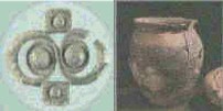
Within Falkirk District along the route of the Antonine
Wall, many interesting finds have been uncovered. Roman shoes,
fragments of pottery, an iron axehead and an iron javelin are
among the items on display in Kinneil Museum. A bronze strap
fitting, possibly worn by one of the soldiers, is one of the most
interesting items.
At Bridgeness, in 1868, a stone 'distance slab' was found, and was
subsequently presented to the National Museum of Antiquities in
Edinburgh .A replica of the slab's inscription can be seen in
Harbour Road Bo'ness. |

