|
While the county is well
watered, it possesses no great river entirely its own flowing directly into
the sea. The Deveron is shared with Aberdeen, the Spey with Inverness and
Moray, though the main drainage area of the former is in Banffshire, and
from Banffshire comes the largest tributary of the latter.
"I hae a kintra," runs a rhyme attributed to Jane Maxwell, Duchess of Gordon
I hae a kintra caa'd the
Cabrach,
The folks dabrach,
The water's Rushter,
An' the corn's trushter.
In its comparative isolation
the Cabrach is a little territory by itself, hence the "the" used before the
name; it is called never Cabrach but "the" Cabrach. It is in the wild
recesses of the Cabrach that the infant Deveron originates, in a land of
heath-covered hills, of barren moors, and of far-stretching, rugged deer
forests. The climate is unkindly, winter lingers long, so that, while the
valleys are devoted to a somewhat precarious course of arable farming, it is
a district of cattle- and sheep-rearing rather than of grain-growing. From
the Cabrach to Rothiemay the Deveron flows through Aberdeenshire. The stream
in its upper stretches runs rapidly along a series of glens and is
frequently subject to violent freshets. All the bridges above Huntly were
swept off by the historic floods of 1829. At Huntly it is joined by the
Bogie.
At the point where the
Deveron again touches Banffshire, it receives the waters of the Isla, which
issues from beautiful Loch Park, and runs through the parishes of Botriphnie,
Keith and Grange. The Deveron now goes eastward by Marnoch, passing finely
situated mansion houses, on to Inverkeithney, where the Burn of Forgue
enters, coming from storied Frendraught and Glendronach. Still holding east,
it nearly reaches Turriff but turns very abruptly northward. At the elbow it
is joined by the Water of Turriff. Near the same point it is spanned by a
bridge of three arches, of Delgaty freestone. The river flows on past
Forglen House, in charming scenery, Mountblairy and Denlugas, to receive the
Burn of King Edward. This stream comes from the east along the valley of
King Edward. One of its branches begins near the church of Gamrie, within a
short distance of the sea, and after a course of nine miles joins the
Deveron at a point five miles from its mouth.
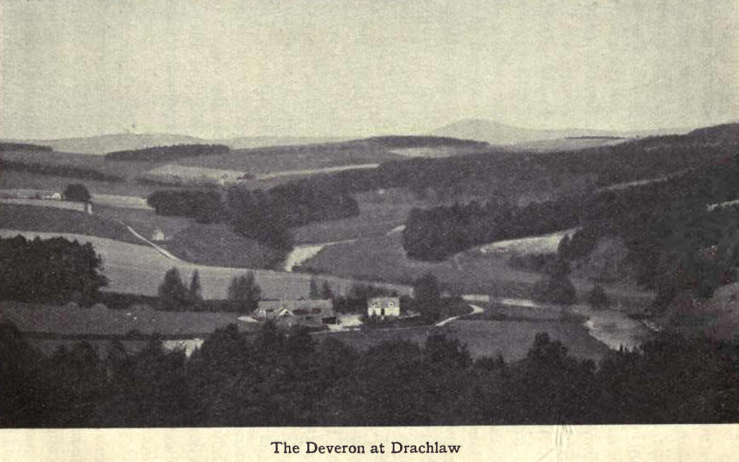
The Deveron now passes the
ruins of Eden Castle, and, turning westward, enters the picturesque and
romantic narrows between the Hill of Alvah and the Hill of Mont-coffer. Here
a precipitous chasm is spanned by a bridge erected by the Earl of Fife. The
chasm under the bridge is narrowed by the rocks to 27 feet, while the depth
of the
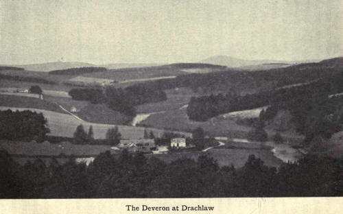
water is 50 feet. To the
north of the bridge the rocks recede, rising to 100 feet above the water,
and are fringed and covered with a rich diversity of shrubs and trees. Soon
a fine valley gradually opens out. The river sweeps round its eastern side
and encloses the plain on which Duff House stands. Half a mile hence it
reaches the sea beneath the "Bonnie Brig' o' Banff." Until i 763 the river
was crossed by fords and ferry boats. The first bridge was destroyed by a
flood in 1768. The present bridge, designed by Smeaton (of the Eddystone
lighthouse), was opened in 1780, and was widened in 1881. It is a beautiful
structure of seven arches, and has a free waterway of 142 yards. The length
of the Deveron is just short of 62 miles.
The Spey is nearly 50 miles
longer than the Deveron and drains an area of over 1200 sq. miles. It rises
at a great height above sea-level and receives a huge volume of water from
numerous tributaries; and thus in its lower reaches it is the swiftest of
Scottish rivers.
The Spey touches Banffshire
close to Ballindalloch Station and soon after receives, at Inveraven, its
largest and most beautiful tributary—the Aven, locally the A'an. The Aven
flows entirely through Banffshire territory, traversing in its course of
about 40 miles some of the finest scenery in the county, almost matchless
for wild and rugged grandeur. It is a deep and rapid stream, clear as
crystal.
The water o' A'an so fair and
clear,
Would deceive a man of a hundred year.
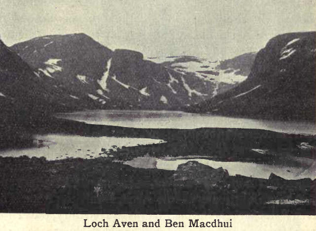
It has its source on Ben
Macdhui and issues from Loch Aven, already a considerable stream, flows
through the entire length of the parish of Kirkmichael and falls into the
Spey in the adjoining parish of Inveraven. Near Delnabo it is joined by the
Water of Ailnach; and north of"I'omintoul by the Conglass, from the hills
overlooking Strathdon. A little further on it receives the water of the
Chabet, and in the kindlier region of Glenlivet the Livet, swollen here into
a considerable stream by the tributaries of Crombie and Tervie. The former,
which drains the Braes of Glenlivet, falls into it at Tombae, and the
patter, which drains the

district of Morinsh and the
lands bordering on Glenrinnes, at Tombreakachie. The Aven, at its beginning,
is about 4000 feet above the sea; at the Builg Burn, where it turns north,
1300 feet. At St Bridget, Tomintoul, it has fallen to 1000, at the Livet to
600, while the haugh at its junction with the Spey is 500 feet above the
sea. The greater part of the Aven valley is interspersed with
natural-growing birch and alder, which adds much to the grace and beauty of
the scenery and makes a tour by the road skirting its banks an ever pleasant
memory.
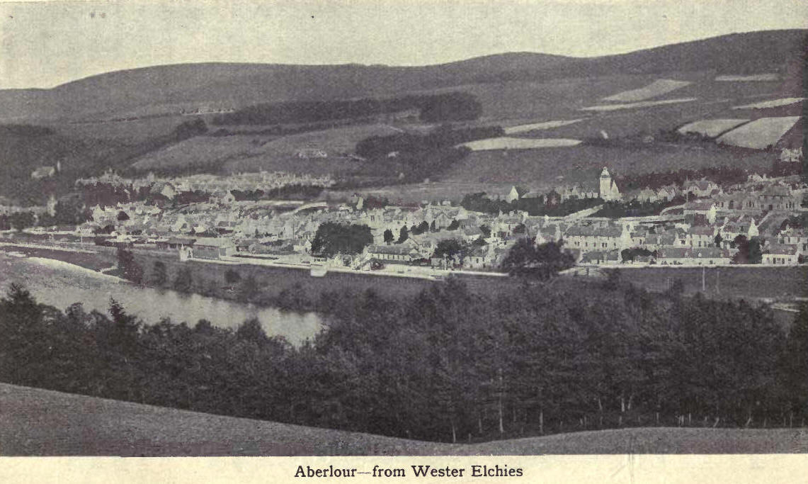
From Inveraven the Spey flows
past Aberlour, and on through beautiful scenery to Craigellachie, where it
is joined by the Fiddich. The Fiddich rises in Glen Fiddich, the fine valley
where the Duke of Richmond and Gordon has his deer forest and hunting lodge.
The Dullan descends from Glenrinnes, the valley to the west of Glen Fiddich.
The two streams unite at Tininver ("the meeting of the waters") below the
church of Mortlach, about five miles from the Spey. Their whole course is
about twelve or fourteen miles.
From Craigellachie, the Spey,
amid superb scenery, rushes in majestic curves past the gloriously wooded
heights of Arndilly. At Ordiequish it leaves Banffshire and dashes through
Moray to the sea.
For salmon the Spey stands
high; for trout it falls below the Aven, which is in great repute with
anglers. The Deveron is famous for both trout and salmon. As far as records
go the heaviest Deveron salmon was landed from the Eden water on the last
day of the season of 1920. It weighed 56 lbs., and measured 53 inches in
length, and 29 inches in girth. In the same section of the river in the
spring of 1920 a sea-trout of i6i lbs. was landed, the heaviest Deveron
trout recorded.

The lakes in the county are
not numerous, but fewness is compensated for by picturesqueness. Loch Park,
in Botriphnie, is among the most charming of Highland lochs. Its beauty is
familiar to many, since the railway skirts its shores. About a mile long,
with a mean breadth of 100 yards, Loch Park occupies the base of a mountain
gorge, the wooded sides of which rise to a considerable height. Here is the
watershed of the district. The Isla, issuing from the east end of the loch,
runs to the Deveron, while streamlets to the west of this glen reach the sea
through the channel of the Spey.
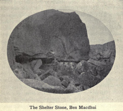
Loch Aven, three miles long
and one mile broad, is in the southern extremity of the parish of
Kirkmichael and lies picturesquely amid wild and magnificent scenery. The
towering heights of Ben a Bhuird, Ben Macdhui, Cairngorm and Ben Bainac rise
all around it, and their rugged bases skirt its edges, except at the narrow
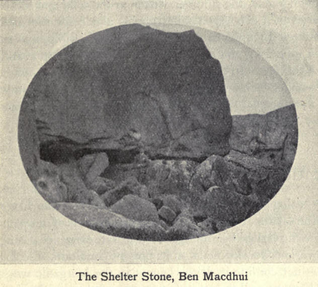
outlet of the Aven. Its water is luminous and of great depth. At its western
end is the famous Clachdhian or Shelter Stone, an immense block of granite,
forming the broad shoulder of Ben A4acdhui. The stone rests on two other
blocks imbedded in a mass of vegetation, and forms a cave sufficient to
contain twelve or fifteen men. Here, where the queen of the storm sits, at a
distance of a score of miles from all human abode, the summer visitor to the
wild and sombre glories of Loch Aven takes up his abode for the night.
Between Inchrory and the Cairn is Loch Builg, upwards of a mile long and
about half that breadth, at an altitude of 1566 feet. In these mountainous
regions are a number of smaller lochs, even the names of which are
unfamiliar to most people, for in these wastes of rugged hill and moor they
are seldom seen by human eye. |