|
EXCURSIONS.
The Editor will be glad to receive brief no/ices from
Members of any noteworthy expeditions undertaken by them. These are not
meant, however, to supersede longer articles.
THE CAIRNGORMS.—On 2nd July I and my brother, D. D.
Dewar, walked from Blair Athole to Braemar by Glen Tilt, and on the
following day we climbed Beinn a Bhuird, one of the Cairngorm range. We
forded the Dee opposite the stalker's cottage, somewhat to the left of the
old Castle of Braemar. The river, on account qf the long drought, was just
practicable, being somewhat more than knee deep; but an additional wetting
was neither here nor there, as the rain was falling in torrents and looked
like doing so all day. Prolonged parley ensued with the stalker, but in the
end we prevailed upon him to allow us access to Gleann an-t-Slugain; he, as
a conscientious servant, however, making a point of accompanying us to the
foot of the hill. So strict are the injunctions even at that season against
admission to the forest. A walk of about five miles up the lovely glen
brought us to the Q uoich Water. Crossing it, an easy ascent was made to the
first cairn (3,86o feet), in pouring rain and dense mist; one or two snow
slopes which had lost much of their virgin whiteness being easily negotiated
en route. Thence a monotonous tramp of three miles, according to our friend
the stalker, led to the higher cairn (3,924 feet). As we were in dense mist
from an altitude of 3,000 feet, I am, unfortunately, unable to speak as to
the capabilities of the hill; but from what was seen of it, it seemed to be
for its height a disappointing one, hardly worth overcoming the "forest"
difficulties of getting to it, not to mention the grind of the long walk
from the one cairn to the other, with an ascent of only sixty-four feet
between. In good weather, however, no doubt it may be very different,
particularly if the ascent be made by keeping to the source of the
right-hand fork of the Quoich, and thence to the saddle between Beinn a
Bhuird and Ben Avon. This route should bring into view some fine corries and
precipices. Our descent was made into Glen Quoich, which contains a
considerable remnant of what must have been at one time a splendid forest of
Scotch firs and larches, but sad havoc has been made among them by many a
wild storm. The survivors, however, are magnificent trees, and a more
beautiful glen it has seldom been my good fortune to see. The upper part of
it must be comparatively unknown, as it is most jealously guarded, being, I
understand, contiguous to the Mar Forest sanctuary. Comfortable quarters for
the night, including a complete change of our soaked garments—thanks to the
kindness of our entertainer—were found in a cottage not far from Glen Lui.
[Members of the club will be supplied with the address on application to the
Editor. For satisfactory reasons publicity is not given to it here.]
On the morning of the next day, the 4th, we left for
Aviemore by Glen Lui and the Learg Ghruamach, intending to take Ben Mhuic
Dhui en route, by ascending it near the burn which falls into Glen Dee. On
coming in sight, however, of Cairntoul, the latter offered such attractions
that it was resolved to substitute it for its burlier neighbour. The Dee was
accordingly forded a hundred yards or so higher than the watchers' bothy,
and we at once entered upon a most enjoyable climb, taking a straight line
for the rocky ridge lying between the two corries,—or, in other words, at
the point where the four altitudes, 2,000, 21500, 3,000, 3,500 are printed
on Bartholomew's 2-mile to the inch map. The hill here, as will be seen,
ascends very steeply, and great part of the climbing is over large boulders,
affording splendid foothold. These, as the top is. reached and for perhaps
two hundred feet, give place to rock; and the ridge for some distance
becomes sharply defined, so that at any time excellent climbing could be
got. Our interesting ascent was all the more appreciated after our previous
day's tame work on Ben a Bhuird, and by contrast with the unbroken side of
Ben Mhuic Dhui opposite. Leaving the cairn and entering the corrie which had
lain to our right while ascending, we rapidly made our way to the glen
beneath, and the track was again struck which led us through Rothiemurchus
Forest. Via Aviemore, Linwilg Inn was reached about 6.30, our enemy the
rain, immediately on our crossing the county march at the top of the pass,
having come down again in torrents, completely drenching us for the last
three hours. This necessitated another requisition of clothing at the inn,
which was most promptly supplied. I may mention that the time occupied by
the actual ascent and descent of Cairntoul was somewhat under one and
three-quarter hours, which might seem to be a "record" for a hill of 4,241
feet, until it be remembered that the right-of-way track is left at a height
of 2,000 feet. We also explained it to our satisfaction by giving the credit
for it to the magnificently bracing air. Until that day I was prepared to
give the air of Rannoch the palm, but now I pin my faith to that of the
Caimgorms.—FRANCIS J. DEWAR.
THE BEN MORE GROUP.—A party of six (the Sandah Club)
climbed the Ben More Hills on Monday, 13th April. Left King's House Inn at
10 A.M., reaching the east end of Loch Dome at twelve. Turning up the Alit
Carnaig we ascended the stream to an altitude of about 1,750 feet, where we
began to meet large patches of damp snow. We now kept an easterly course,
and made for the shoulder of Stob Coire an Lochan, the top of which we
reached about two. Pushing on, less than half an hour found us at the summit
of Stobinain, where a halt was called for some twenty minutes. Starting
again, in ten minutes we covered the z,zoo odd feet that lay between us and
the saddle, a few rapid glissades materially helping the pace. The final
ascent to the top of Ben More had a little of the "last straw" element in
it, and was felt somewhat fatiguing, but the summit was gained about
half-past three. Here a lengthened rest was indulged in. It is not often
that you enjoy the luxury of resting your tired limbs by reclining on pure
snow, soft and dry, 3,800 feet above your ordinary vocations, with the sun
shining in your face, and not a breath of air stirring, while you kick your
heels into the azure, and growl at the man who tells you to get up and be
photographed. But too long a halt must be guarded against, and about four
o'clock we commence the descent by the steep shoulder on the north-east.
After coming down a few hundred feet on to the plateau which surmounti the
frowning precipice on the north, we have to work carefully round to the
right along a frozen face at an uncomfortably acute angle, but at last we
reach a steep slope of deep soft snow, and we are off like rockets going the
wrong way. We now make an almost straight line for the point where the road
crosses the railway, passing close to the iron cross which marks the spot
where an unfortunate mountaineer lost his life some years ago. The whole
descent occupied rather less than an hour, about 2,500 feet being glissaded.
Some of the glissades must have been fully five hundred feet long, and the
pace was often wild. We took a short drop of six or eight feet in the middle
of one of them. The effect was superb, the switchback not in it. As was to
be expected, the snow was lying much further down on the north than on the
south side of the hills, it was in most places very soft, and walking was
occasionally difficult. Our glissades were not made in the orthodox fashion,
but in a way likely to help our respective tailors' accounts. The softness
of the snow made this the only feasible plan. But in spite of the mildness
of the weather the snow seemed quite dry, except on the lower slopes. Owing
to the haze which hung around there was not much of a view. But, as some one
remarked, climbing is its own reward, and we had our magnificent glissades
into the bargain.
Let us draw a veil over the West Highland Railway
desecrations at Crianlarich. We advise members of the S.M.C. to avoid the
hotel there during the next twelve months or so, unless they are more than
usually anxious for the society of drunk navvies.—J. M. M.
WINDLESTRAW LAW (2,161 feet)-91h May 1891.—My brother
and I left Fountainhall Station on the arrival of the 1.40 train from
Edinburgh, and proceeded leisurely up a farm road to Howliston, and then on,
mid cultivated fields, to Nether Shiels. Here we left the road, crossing the
Lugate, and turned up by the side of the Calfhope Burn. The fragrant grass
and short stumpy heather of the hills were now underfoot, with a delicious
mountain breeze playing vigorously in our lungs, giving strength and energy
to every limb; and the song of the lark mingling with the calls of the
cuckoo, curlew, and plover filled the air with a concord of sweet sounds,
that is ever the harmonious accompaniment of a mountain tramp in the
Lowlands at this season. Missing the Deafhope heights by keeping too far to
the south, we found ourselves at the Cadon Water by 4.30; and crossing this
where a pony track commences, we go on to the gently sloping shoulder of
Windlestraw Law (between Birchope Burn and the headwaters of the Cadon),
which is covered with strong wiry grass and about half a mile of peat haggs.
The summit, 2,161 feet, unmarked by a cairn, was reached at 5.20, from which
an extensive view was had, the triple peaks of the Eildons standing out well
in the east; North Berwick Law and Arthur's Seat away in the distance
marking the line of the Forth; the Pentlands, purple in the light of the
setting sun; the great round- backed, kindly, solemn hills of Tweed, as Dr
John Brown describes them, lying like sleeping mastiffs, too plain to be
grand, too ample and beautiful to be common-place, were all around us.
Gradually descending by the side of a grassy ridge to the Leithen Water, we
struck the road at Coiquhar farm at 6.30. Three miles more in the Leithen
valley brought us to Innerleithen at 7.10, where we were comfortably housed
for the night at the Traquair Arms.—W. D.
MINCHMOOR (1,856 feet)—zoth May.—We left Innerleithen
about eleven; passed Traquair House and turned to our left, up an old drove
road which begins near some cottages a hundred yards or so beyond where the
Peebles road turns off to the right, and leads almost to the substantial
cairn built on the top. This hill has been so exquisitely described by Dr
John Brown in his paper Muschmoor, that no room has been left for further
description. Three hours is ample time to allow for the ascent—up and
down—from Innerleithen.—W. D.
BEN CLEUcH (2,363 feet), from Dollar to Dunblane—zótlt
May i8pz.—Leaving Edinburgh by the 1.20 train, we passed Dunfermline in a
rattling hailstorm. Changing carriages at Alloa, we found that "the
connection" arranged for in the time-tables could not be made. After a most
annoying detention of an hour we were landed at Dollar at 3.30, which put it
out of our power to catch the seven o'clock train from Dunblane to Callander
as we had intended. Passing Castle Campbell, some more time was put off by
following a path on the east side of the stream which ended in a cut tie
sac. Retracing our steps, and crossing the stream by a bridge close to the
castle, we climbed a steep grassy bank which took us into the valley of the
Burn of Sorrow. This stream was followed to its head, between pastoral hills
and well-marked moraines on the south bank. We reached the cairn on Ben
Cleuch at 5.45, and got a wonderful view of Ben Vorlich, Stuc a Chroin, and
Ben Ledi, with every rent and scaur in their torrent-torn sides unveiled to
view, backed by range beyond range and peak above peak of virginal whiteness
of the snow-clad hills to the north and west. The cold unfortunately was so
intense that we could not stop long enough to pick them out by name. In
crossing some peat haggs to Blair-denon Hill (2,072 feet), we were nearly
frozen in the icy cold wind, and not till we got into the shelter of Glen
Tye could we get the benumbed sensation out of our fingers. This glen opens
out on the battlefield of Sheriffmuir, and three miles of road walking
brought us to Dunblane at 8.30. What we saw of the Ochils showed us that
they are well worthy of being thoroughly explored. Their long-backed grassy
ridges and rounded heads are as fine of their kind as any I have seen, while
the views from their tops far surpass any to be had from hills south of the
Forth.—W. D.
BEN VORLICH, Perthshire (3,224 feet), from
Callander-61h May.—Left the Dreadnought at 10.30, followed the Comrie road
for five miles to Arivurichardich (12 o'clock), crossed the shoulder of Stuc
a Chroin at its lowest point, descended to the Gleann an Dubh Choirein (z
o'clock)—with the two splendid corries on our left—and reached the top by
the east shoulder at 12.15. Another gorgeous view rewarded our efforts, in
which Lawers, Stobinain, and Ben More, still whitish with snow, played
prominent parts; and the dark frowning cliffs of Stuc a Chroin, streaked
here and there with lines of white, showed up well its scarred and louring
face. The day was particularly fine, with heavy clouds, intervals of bright
sunshine, and only one little hail shower in the forenoon. The whole hill
seemed to be swarming with white hares, judging from the numbers that
crossed our path; some deer also were seen near the top. Leaving Stuc a
Chroin for another day, we returned to Callander by the same way as we had
come, and arrived at 5.35.—W. D.
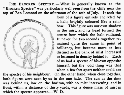
BEN LOMOND (3,192 feet), Rowardennan, by the head of
Loch Chon, to Aberfoyle-241h May.—On Saturday afternoon the two o'clock
train from Edinburgh and steamer from Balloch landed R. T. and myself at
Rowardennan about six o'clock. As we neared the pier we got a grand view of
the Ben, which had until then been enveloped in clouds; these parting,
revealed its rounded head crowned with the delicate silver tracery of
freshly fallen snow. Next morning at 9.40 we were under weigh, and in a
couple of hours topped this popular mountain. The first mile took us over
some rather boggy ground, but when the south shoulder was reached dry
footing appeared, and the well-built "carriage read" took us to the top. We
found the view from this route very tame; misty in the south, and shut in on
all sides. The loch, of course, was there, but distance does not enhance its
beauty. This, however, made what was in store for us all the more
impressive. When the ridge overlooking the splendid rock cliffs was gained,
oh, what a feast was there! The whole range of hills from Oban to Callander
gradually came into view—Cruachan, Ben Bhuidhe, Ben Lui's (four) tops, Ben
Doran and the Crianlarich Hills, Ben More and Stobinain, Ben Vorlich and
Stuc a Chroin, and a host of others— recalling many a happy day spent among
them. Ben Nevis's great bulk was made conspicuous by the sun striking on his
snowy sides through a rift in the clouds; and the Arrochar mountains lay
within a figurative stone's throw from us, across the loch. The best part of
an hour was spent with compass and map naming all the hills within sight,
and enjoying to the full this impressive and wonderful view. In descending
by the north side we attempted, not without some success, a standing
glissade on a narrow strip of hard snow for about eighty feet. The descent
was fairly steep in places, but with a little care we reached Caoram Achaid
moss at the foot without difficulty. To avoid as much of the "dip" as
possible we kept close under Cruinn a Bheinn in crossing the moss. This gave
us only a rise of a couple of hundred feet before descending other five
hundred to the Glean Dubh, where we lunched at 1.3o. The next ridge was
crossed between Uaimhe and Beinn Dubh, and the farm Frenich at the head of
Loch Chon was passed at 2.50. We had intended to make for the Trossachs,
over Ben Venue, but as the weather looked far from pleasant and a heavy
shower of rain came on, we judged it more prudent to make for Aberfoyle, and
eight miles of road walking brought us there. Like the worthy Bailie in Rob
Roy, we gained admittance to the inn; but not possessing his warlike
proclivities, were unable to make good our quarters for the night, and had
to march another five miles to the Port of Menteith. An enchanting row on
Scotland's only lake, with a visit to lnchmahome in the weird light of the
gloaming, brought our tramp to a close, and an early train next morning
rattled us into town by 9.30.—W. DOUGLAS.
A DAY ON THE MOFFAT HILLS.—On 21st May (Queen's
birthday) Messrs Douglas and Cowan, with four friends, - Messrs J. Douglas,
Dewar, Sang, and Gillespie,—left Moffat about 9.30, driving up Moffatdale to
the point where the road is left for the Grey Marc's Tail. A cold wind was
blowing down the valley, and we were not sorry to leave the trap and set our
legs in motion. Starting from this point about 11.10, we climbed quickly up
the roughish ground at the side of the fall, and then, having crossed the
burn, bore slightly to the right till we came in view of Loch Skene. We then
determined to make for the top of Loch Craig Head, the screes of which run
steeply down to the north-cast margin of the loch. We ascended by a very
steep grass slope immediately to the east of the screes, and reached the top
(2,625 feet) at 12.40. The cold wind here blowing from the north-east
dispelled any desire to linger, and we accordingly proceeded to round the
head of Loch Skene, in order to reach White Coombe, the highest point in
Dumfriesshire. A descent of about 500 feet brought us to a point from which
we had an exceedingly fine view of this lovely little loch, lying in a
veritable cradle of bare stony slopes topped by precipitous crags. A gradual
rise from this point soon brought us to the top of White Coombe (2,695
feet). From this we made for the long flat ridge of Hartfell, keeping to the
watershed between the Annan and the Tweed, and crossing a collection of
peathaggs, appropriately named (on the one-inch Ordnance map) Rotten-
bottom, we reached the top of Hartfeli (2,651 feet) at 3.20, and here the
sun succeeded in dispersing the clouds, which had till now been threatening
to descend upon us, and we enjoyed a longer stop than any we had yet made,
especially as Hartfell, being nearer the edge of the group, affords a much
more varied view than the other hills we had traversed. Keeping along the
ridge towards Swattlefell, from which we had a good view of the very steep
rocks and screes on both sides of the glen formed by the Blackhope Burn, we
struck down the valley of the Birnock Water, and reached Moffat at 5.40,
after a most enjoyable tramp of about fifteen miles.—W. COWAN.
THE DALWHINNIE MEET.—Munro arrived mid-day, Friday,
1st May, Rennie the same evening. Snow lying in large patches, even down to
the level of the railway.
Saturday, 2nd May.—Heavy snow in night, lying some
inches deep on the low ground, and six inches to a foot on the higher
ground, often covering old snow which was nearly as soft as the new. Still
failing when at 9.15 Rennie and Munro started. To avoid the double journey
over the road to Loch Ericht Lodge, struck over the moor behind the station
in deep snow, crossing a shoulder of Meall Cruaidh at a height of about
2,200 feet, worked round the back of the bill, and then dropped down to the
Pattack, which was in heavy spate. Crossed by a rickety bridge just over a
fall at 12.45 (height 1,200 feet about). By this time the sun had come out
bright, and the snow was fast leaving the low ground. A quarter hour for
luncheon. Easy ascent. At three P.M. reached Srôn Garbh, 3,206 feet (name
and height from six-inch O.S.), a short half-mile E. of Mullach Coire an
Iubhair which was reached at 3.20. Fair views—Carn Dearg, Ben Alder, Geal
Charn, Sgbr luthama (the "Lancet Edge "), portions of the Creag Meaghaidh
range, &c. Hence to Creag Peathraich (3,031) in fifty minutes, where quarter
hour's halt. The col at 4.50. A short sharp pull of twenty minutes and a
long hour's plod over gently rising ground in deep snow and thick mist,
which had now closed in, to Beinn a' Clachair (,69) at 6.15. A line of small
cairns leads up to the top, on which is a big cairn. The Alit Cam an Leirg
was reached at 7.10, the lower ground being clear of mist and snow.
Villainous peat haggs between here passed it at 4.40 at a height of about
1,300 feet, and set foot on Ben Chaluim. We rose diagonally on very steep
ground along the flank of this hill, aiming for the col just below his bold
peak. It was steep enough occasionally to call for help from the hands. We
reached the top at 6.1. The chief feature was the splendid view to the south
of Ben More, Stobinain, and the rugged Ardran group. Ben Chaluim's height is
3,354 feet. It is double topped, the lesser or south top being cleft
throughout its line by a curious depression or fault, whose western edge is
a little rocky rampart. We made a straight line down a long easy ridge to
the F.C. Manse at Auchtertyre in Strathflllan, and got back to Tyndrum at
8.30. A very easy day of perhaps twenty miles. Next morning Macpherson left
us to tramp through Glen Lyon; while Douglas and I took train to Crianlarich,
and at ten A.M. started for Cruach Ardran. The ascent of this fine hill
(3,477 feet) by way of Coire Ardran took two hours twenty minutes. Fine
views from summit. Thence we dipped S.S.E. for about 700 feet to the col,
and rose again to Ben Tulachan (3,0 feet). We descended to the west, crossed
the Earb Water, skirted beneath the fine crags of Stob Ghlas (see Mr Dewar's
paper, pp. 118-22), struck the upper waters of the Falloch, were warned off
the Caisteal—which we had intended climbing—by a thunderstorm and a terrible
downpour, and got back to Crianlarich at four P.M.-J. G. S.
|


