Dr. John Rae, for thirty-five years a Corresponding Member of
the American Geographical Society, died at his home in London on the 22d of
July last. An attack of influenza in April had left him in a weakened
condition, though he kept up with surprising energy and interested himself
in his usual occupations to within a few days of his death.
Dr. Rae was born at the Hall of Clestrain, Pomona, Orkney
Islands, September 30, 1813. He studied medicine at Edinburgh and took his
degree from the Royal College of Surgeons in 1833; and shortly after went
out in a Hudson’s Bay Company ship to Moose Factory, on Hudson’s Bay. There
he remained in the service of the Company till June, 1846, when he set out,
at the head of a party of ten men, in two boats, to survey the 700 miles of
coast which separated Ross’s explorations in Boothia from those of Parry at
Fury and Hecla Strait.
Rae started from York Factory, with four months’ provisions
but no fuel, on the long voyage to Repulse Bay, where he wintered in N. lat.
66° 32'. The survey was accomplished in the spring. A memorandum in Dr.
Rae’s handwriting says, of this expedition and the one of 1853-4:
In both of these he carried with him only four months*
provisions for his party, and was absent fifteen months, having on return to
York Factory one and one half month’s provisions remaining. All game and
fish for food were obtained by the party; chiefly deer. We had not a bit of
fuel to warm our stone house with, and the smoke of the andromeda used for
cooking would not go out by the chimney. We had to keep the door open all
the time of cooking, as the smoke was very pungent. The temperature usually
fell 15 or more degrees when the cooking was going on. We (had) no oil for a
fire lamp in the snow hut in 1853-4.
In 1848 Dr. Rae, as second in command, accompanied Sir John
Richardson’s expedition from the Mackenzie River to the Coppermine, in
search of Sir John Franklin; and he descended the Coppermine, after
Richardson’s return to England. The next year, with two men, he made a
sledge journey along the coasts of Wollaston and Victoria Land. The daily
march was twenty-five miles, Rae pulling his own sledge and inspecting
personally every turn of the coast. The journey was continued to Winnipeg
and thence to Crow-Wing, Minnesota. In this expedition, which lasted nearly
eight months, and covered more than 5000 miles, Rae explored seven hundred
miles of coast previously unknown.
The Founder’s gold medal of the Royal Geographical Society
was awarded to him in 1852, and in 1853 he took command of another
expedition, fitted out expressly for him by the Hudson’s Bay Company, for
the purpose of tracing the west coast of Boothia as far north as Bellot
Strait and uniting the surveys of Sir James Ross and Dease and Simpson. His
success was complete ; he surveyed 400 miles of coast not laid down on the
map and proved that King William Land was an island.
Among the Eskimo he found and secured many relics of Sir John
Franklin’s party, and the information he acquired dispelled the mystery
which had shrouded the fate of those heroic men. When Dr. Rae returned to
England Sir James Graham, the first Lord of the Admiralty, told him that
“his party was entitled to a reward of ,£10,000 for bringing the first
information of the fate of the Franklin expedition, and that he would stand
in his own light if he did not put in a claim for it.” The claim was made
and satisfied.
In 1860 Dr. Rae made surveys in the Faroe Islands, Iceland
and Greenland for a proposed line of telegraph to America; and in 1864 he
began another survey for a line from Winnipeg across the Rocky Mountains. In
the course of this latter enterprise he accomplished the descent of the
dangerous Fraser River for several hundred miles in a canoe and without a
guide.
Dr. Rae published but one book, the “Narrative of an
Expedition to the Shores of the Arctic Sea in 1846 and 1847.” His other
expeditions are described in brief reports addressed to the Royal
Geographical Society, and he is the author of papers on the Eskimo, on the
navigation of Hudson’s Bay, and on Polar exploration ; but his written
contributions, though they testify to his thoroughness and accuracy and to
his rare qualifications, bear no proportion to the magnitude and the
solidity of his work. He wrote with simplicity and force, but he was more
concerned to do things worthy of record than to record them. He had the
gifts of the born explorer, the habit of exact observation, courage and
fertility of resource, untiring energy, activity and strength ; and with
these a firmness and generosity of character that won the respect and the
affection of men.
A funeral service was performed in St. John the Baptist’s
Church, Addison Gardens; but the body of Dr. Rae rests at Kirkwall, in the
churchyard of St. Magnus Cathedral.
DR. JOHN RAE’S ARCTIC EXPLORATIONS
Editor the Bulletin. American Geographical Society :
Dear Sir : You may have among your collection of English
Admiralty charts one dated 1855, having the south shores of Wollaston and
Victoria Lands drawn upon it, and also my discovery of Victoria Strait (in
which Franklin’s ships got ice-bound and were abandoned by their crews in
1848)—on a searching expedition, employed by H. M. Government—myself and my
ten or twelve men being, however, of the Hudson’s Bay Co.’s Service. I in
1851 searched closely, surveyed and mapped out about 750 miles of the coast
above named, about 140 miles of which between longitude 105° and 1 io° W.
had, however, been roughly traced by a previous expedition. The 600 odd
miles of my survey—all new ground—were part of that, for which I was awarded
in 1852 the Founder’s Gold Medal of the Royal Geographical Society of
England, in the Journal of which (1852), vol. 22, will be found the record
of the award of the medal, the President Sir R. Murchison’s speech when
presenting it, and my Report and chart of the survey.
Now comes the strange part of the story. Captain Collinson,
R. N., in H. M. S. Enterprise, had come through Behring Strait, also in
search of Franklin, in 1851, and in 1852-53, by ship or sledge, passed along
the same coast that I had surveyed a year before, but did not get back to
England until late in 1854.
On the 29th of December of that year, I received a letter
from Admiral Beaufort—then about to resign his position as Hydrographer of
the Admiralty to Captain Washington, R. N.,—of which the following is an
accurate copy:
Admiralty, December 29, 1854.
Dear Dr. Rae: I am endeavoring to put into our Arctic chart
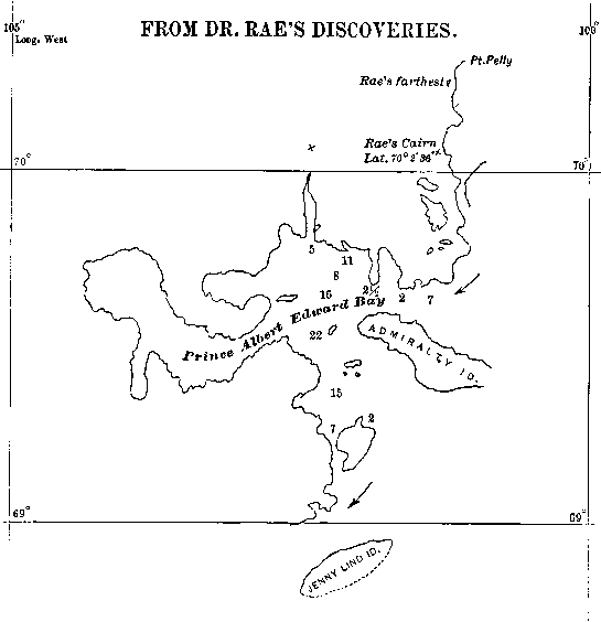
Captain Collinson’s track, and, as far as Cambridge Bay and the Jenny Lind
Island (Collinson made Jenny Lind Island part of Victoria Land, although
some miles from that shore, with a deep ship channel between. J. R.) of your
drawing, we get on pretty well by taking his points, and adopting your more
minute detail of the shore. But from your Jenny Lind Island up to your Pelly
Point, in Latitude 70° 20' N., I can in no way possible reconcile the
apparent configuration of the coast in the two tracings, as you will
perceive by the enclosed copies. His Driftwood Point, I suppose to be the
eastern end of your Admiralty Island (Yes. J. R.), but I know not where to
find your broad opening into Albert Edward Bay—can you put me on any scent
likely to solve my difficulties ?
Yours very truly,
(Signed) F. Beaufort.”
I enclose a correct copy of the above named tracings. The Bay
referred to, which I surveyed and sounded in my boats, has a coast line of
about 200 miles, which Collinson passed and repassed without seeing it! A
very short time after this, in January, 1855, a chart of
Note by Dr, Rae.—Two of my men went eight or ten miles beyond
this point. The land being a dead flat, I saw them with telescope from an
ice hummock at least five or six miles out.—J. R.
This coast was sent me by Captain Washington, then Hydrographer, with the following note inserted :
“From Cape Back round this Peninsula to Gateshead Island (my
Point Pelly) the outer line of the coast has been determined by Captain
Collinson, and the lakes and inner bays (The bay having a coast line of 200
miles being one of these inner bays. J. R.) adapted from Dr. Rae.”
Note by Dr. Rae.—My discoveries are cut down to the point
where I took my latitude with sextant, 70° 2' 36", whereas two of my men,
active young fellows, walked at least eight or ten miles farther. The shore
being flat as a table, I* saw them with my glass five or six miles on their
way, I being on an ice-heap fifteen feet high.
Collinson is allowed to put down land seen thirty miles
off.—J. R.
For an obvious purpose no dates are given.
When I tell you that nearly the whole of Captain Collinson’s
chart was exchanged for mine, and errors in one part of even 10 miles of
Latitude were corrected, and a chain of islands, 18 miles in extent, of my
survey with a deep channel inside, made to replace an equal extent of coast
of Victoria Land, as Collinson’s drawing had it, you may suppose that the
arrangement of actually handing over my prior and correct survey (I
say correct, otherwise it would not have been adopted by the Hydrographer,)
to Captain Collinson was not agreeable to me.
Next morning I went, chart in hand, to the Hydrographic
Department of the Admiralty, and asked Captain Washington the meaning of the
note given above. I found the Captain in a very high and mighty humor, quite
quarter-deck fashion, as when speaking to a subordinate, I suppose, when I
remonstrated on the injustice done me, winding up with “ No change or
alteration can be made.” It was now my turn, and I had my remedy handy, and
said : “ Captain Washington, if you have not that objectionable note removed
in a week—I give you a week to think it over—the whole disgraceful
proceeding shall be published in the Times (of which paper my friend Mr.
Delane was then Editor). The Captain looked aghast, and remarked : “ Would
you dare do that to the Admiralty? ” It was, perhaps, not good manners, but
I fairly laughed in his face, saying at the same time, that I had been four
years in the service of the Admiralty, and, setting aside the Hydrographic
officials, had always found them civil, courteous and even kind, but did not
fear them. Repeating my threat, I took my leave. Within four days of the
above little conversation a copy of the Chart was sent me, with the
aforesaid Note covered over with thick cartridge paper, and a letter telling
me that the same would be done with all the copies on hand, and that the
note would be omitted in the next edition.
The next edition soon appeared (that is, in the same year),
and the note above referred to was left out, having had, as far as I knew, a
short life of 5 or 6 days. The Hydrographer, feeling probably a little sore
and uncomfortable at being frustrated by a mere civilian, inserted another
note, as follows :
“The coast from Cape Back to Gateshead Island was discovered
by Dease and Simpson (a Hudson’s Bay Company’s Expedition) in 1839, by Dr.
Rae in 1851, and was passed and re-passed in 1851-52-53 by H. M.
S. Enterprise, Captain Collinson.”
Now, every sentence of the above note, with the exception of
the five words referring to myself, is untrue, and, unless we can suppose
extreme stupidity and ignorance—wilfully so.
Falsehood No. i.—Dease and Simpson, indeed, saw and traced
roughly about one hundred and forty miles of this coast; the remaining part
(more than 600 miles) was my work, and, as I have already said, part of my
discoveries, for which was awarded me the Founder’s Gold Medal in 1852.
Besides this, I corrected Dease and Simpson’s survey in some important
points, where they had not approached the land near enough with their boats
to see clearly the outline of the coast.
Falsehood No. 2.—Neither Captain Collinson, nor his ship
the Enterprise, was ever nearer to any part of the coast named than seventy
or eighty miles, in 1851.
Falsehood No. 3.—The Enterprise never in 1852 -53 passed and
repassed from Cape Back to Gateshead Island. The ship got about half way, as
far as Cambridge Bay, where she wintered, Captain Collinson going on to
Gateshead Island with a sledging party in the spring, 1853.
The above facts seem almost incredible, but the notes —both
entered one after the other in the same chart in the sameyear—speak for
themselves. Probably you have one or other (perhaps both) of these muddled
charts in your Hydrographic offices—the first note being still patched over.
This false note (the second one) has had something like thirty-six years of
an inning—rather an appropriate sporting word for the occasion,—and perhaps
you may, in kindness and fairness of spirit, be inclined to aid in restoring
to their proper owner the six hundred miles of survey, of which I have for
such a very long period been dishonestly dispossessed.
After writing the above, I called at the Admiralty, and saw
the present Hydrographer, Captain Wharton, R. N., who was most courteous and
painstaking in looking over the documents I had brought with me to explain
my rights. He freely acknowledged them, and said he would rectify the injury
that had been done, as far as was in his power.
I may further state that it was only about ten days ago, that
I found out that the last note mentioned, giving Dease and Simpson credit
for the whole survey, was still inscribed on the Admiralty charts, that are
on sale at the present time. My belief was, that on its being pointed out
that the note was false, as I did, the note had been long ago erased or
covered up.
Those who care to do so, especially naval officers, might
probably be permitted to see Captain Collinson’s original tracing at the
Admiralty, or a copy of it at Messrs. Stanford’s, Cockspur Street. Let them
then compare this with the actual outer line of the coast by me, said in the
first note to be Captain Collinson’s, and
any one, at all conversant with cartography, will at once see
what a miserable fiction the whole affair has been.
I beg to subscribe myself
Your obedient servant,
John Rae.
4 Addison Gardens, Kensington,
London, W.
May, 1891.
John Rae Forgotten Hero of Arctic Exploration
by ALISTAIR MUNRO
Published on the
27 September 2013 in the Scotsman Newspaper
A statue to honour Scots Arctic explorer John Rae – who
condemned himself to obscurity for revealing a previous British expedition
had resorted to cannabalism – is to be unveiled in his birthplace of Orkney.
The event at Stromness Harbour is to mark the 200th anniversary of his birth
and celebrate Rae for solving two mysteries of 19th-century exploration.
Born in Orphir on the islands in 1813, he later signed up with the Hudson’s
Bay Company – with the fur trade in Canada at its peak – and charted huge
areas of unmapped territory using his surveying skills.
He uncovered the fate of an earlier expedition by Sir John Franklin, which
included the discovery that the crew had turned to cannabalism in a bid to
survive.
He also discovered the final link in the Northwest Passage, the navigable
Arctic route from the Atlantic Ocean to the Pacific.
He found the route while looking for traces of the Franklin Expedition, who
themselves had been searching for the Passage.
In 1854, he recorded accounts from local Inuits, who said that some of
Franklin’s crew had resorted to cannibalism in a last desperate effort to
stay alive.
He reported his findings to the British admiralty, but was horrified when
they appeared in a newspaper article.
Victorian society, including Franklin’s widow, was left scandlaised, and Dr
Rae’s reputation never recovered.
He died in 1893 in relative obscurity and his memorial lies in Orkney’s St
Magnus Cathedral.
A statue to honour Dr Rae will be publicly unveiled on Saturday evening at
the Pier Head in Stromness.
The donor of the statue – who has wished to remain anonymous until the
ceremony - is expected to make a speech at the unveiling.
There will be an opening performance by members of the Stromness Royal
British Legion Pipe Band.
The unveiling of the full size bronze statue, made by the Orcadian sculptor
Ian Scott of North Ronaldsay, takes place on the first day of the John Rae
200 International Conference being held in Stromness and hosted by Stromness
Museum from September 28-30.
A stone plinth of local granite donated by Orkney Islands Council is already
in place ready to receive the sculpture.
Orkney Islands Council Vice-Convener Jim Foubister said: “We are pleased to
be contributing in some small way during this important year to a permanent
reminder of the achievements of John Rae.
“To many Orcadians, John Rae has not had the recognition he deserves for too
long now.
“I hope the statue will capture the imagination of people both in Orkney and
further afield and help to strengthen his place in history.”
Sculptor Ian Scott also made the well-known statue of the lifeboat man at
Osmundwall Cemetery which stands as a memorial to those lost in the Longhope
lifeboat disaster.
Adventure Canada in Conversation with Tom Muir Commemorating
John Rae
This comment system
requires you to be logged in through either a Disqus account
or an account you already have with Google, X, Facebook or
Yahoo. In the event you don't have an account with any of
these companies then you can create an account with Disqus.
All comments are moderated so they won't display until the
moderator has approved your comment.