|
You
can read a pdf of this article here along with the footnotes
THE publication of Mr. W.
M. Mackenzie's ingenious and revolutionary theory about the battle of
Bannockburn has drawn the attention of scholars to the tactics of the
battle at the appropriate moment of its six hundredth anniversary. I
venture to construct a new theory of the battle, which seems to me
compatible with the authorities on which Mr. Mackenzie relies and also
in harmony with new evidence of charters and other records.
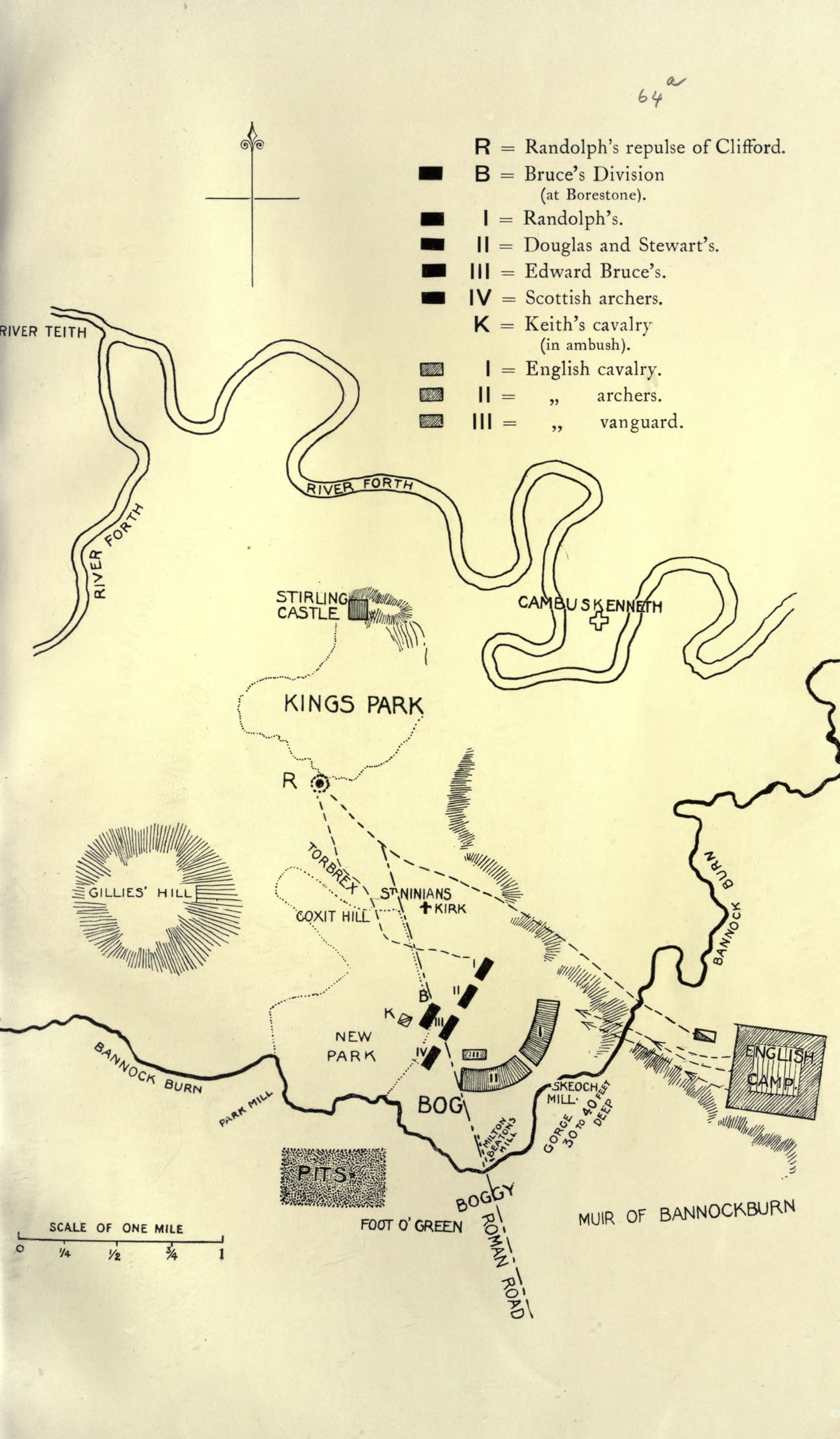
The stress of the present
argument rests upon the limits of the New Park. Any one who is familiar
with the history of the battle will realise the importance of evidence
for the exact situation of the New Park. Mr. Mackenzie's plan places the
New Park a considerable distance to the north of the farm now known as
Coxithill, and about a mile and a half from the Bannock. I believe that
the New Park extended from Coxit Hill to the Bannock. As the Scots
encamped the night before the battle in the New Park, and as Mr.
Mackenzie says that everyone is substantially in agreement that the
battle was fought on the ground between the encampments, it is clear
that a change in the site of the New Park affects the whole argument.
A detailed discussion of
the evidence of the ancient charters and the more modern sasines must be
reserved for publication elsewhere. Meanwhile, the following summary
will indicate the main points on which is based the theory of the
locality of the New Park, which is the basis of a new reading of the
battle, that locality is an area enclosed between Borestone, Parkmill,
and Coxithill, and it can be shown to have been under trees at the date
of the battle. The accompanying sketch map illustrates the sense of the
charters and sasines which transmit the New Park and the adjacent lands
to successive owners from Bruce's day to our own.
Twenty-five years before
Bannockburn made it famous, the New P'ark had very well ascertained
boundaries. Its circumference was carefully measured, and the measure of
its length in feet has been preserved i the Exchequer Rolls. In the
account of the Sheriiff of Stirling for 1289, there is an entry of a
payment for putting up a fence 7200 feet long to enclose it. Fourteen
years after he used it as his base at the battle of Bannockburn, King
Robert granted the New Park, by charter to a vassal named Adam Barber.
The conveyance of the New Park by charter implies the existence of
boundaries, either described in the charter or so familiar in the
district as not to require description. There is no description,
probably because the New Park may still have been enclosed n 1328. The
charter simply states that the New Park is to be held according to all
its right marches. A charter by David II., granted in 1369, proves that
the land was then under wood. A charter of 1455 shows that the New Park
nad been acquired by William Murray of Touchadam, and since that date it
has always been in the possession of the Murrays, whose title-deeds
include the original charter of 29th July, 1328.
The situation and the
boundaries of the New Park can be discovered from documents relating to
the surrounding properties, the limits of which were not so well known
as those of the New Park itself; and therefore required description. The
lands of Torbrekkis (Torbrex) were given by Robert Bruce to a William
Bisset, c1315-1321, and a charter of Robert Bisset in 1533 shows that
New Park was on the south and south-east of Torbrex. A sasine of 1709
indicates that the south and south-eastern boundaries of Torbrex ran
slightly to the south of the road from St. Ninians to Touch, marching
with the lands of Cocksithill. We have therefore reached this point—that
the charter of 1533 speaks of the lands of Torbrex as being bounded by
the lands of Coxit. But the original charter of 1328 grants the lands of
Kokschote, near Kyrktoun, along with the lands of Newpark, and the
Murray sasines show that the names were used interchangeably, Newpark
being the usual description where title is concerned, and Coxit being
employed in descriptions of boundaries. Other sasines show the
distinction between the lands of Newpark and the lands of Blackdub of
Touchadam which form their eastern boundary, and the distinction between
Newpark and the lands of Haggs and Graysteall which bound it on the
west. The whole series of charters and sasines is consistent in leading
us to the conclusion that the lands given in Bruce's charter of 1328 as
Newpark and Coxit, near Kyrktoun, were approximately the present farms
of Parkmill, New Park, and Coxithill, lying to the south and south-east
of Torbrex. In other words, the New Park lay between the road from St.
Ninians to Touch and the road from St. Ninians to Chartershall, and the
traditional Borestone is near the middle of the eastern boundary of the
Park. In what follows, this localisation of the New Park will be
assumed.
On the night of Friday
the 21st June, 1314, the army of Edward II. lay at Edinburgh, and on
Saturday the 22nd it was marching upon Falkirk. When Bruce received this
information he conducted his troops from Torwood on the English line of
march to a point also on the English line of inarch, but much nearer
Stirling Castle, the relief of which was the immediate purpose of the
enemy. The ground to which he removed was well known as the New Park.
Bruce's choice was dictated by the advantage given by a wood to an army
of foot soldiers when the enemy is powerful in cavalry, a circumstance
insisted upon, almost in identical terms, by Bruce in Barbour's poem and
by Wellington in a conversation about the battle of Waterloo. Other
considerations also recommended the choice of the New Park. A camp so
placed had access to a good water supply in the Bannock Burn and the
Kirk Burn, and there was plenty of firewood for cooking purposes.
The danger lay in a
descent of the English upon the New Park from the high ground
immediately to the south by way of Chartershall, where or whereabouts
(and where alone in this locality) the Bannock could be crossed by an
army in good order. This was certainly the natural point for Bruce to
render impassable. In his account of the pits, Barbour indicates that
their purpose was to prevent an attack on the Scottish right, to block
an army route, not to form a trap on a battlefield; he makes Bruce say
on the Sunday evening that there is no place for alarm: the strength of
their position must prevent the enemy from 'environing' them. A tract on
ground by the present old Kilsyth road was dug all over into little pits
the depth of a man's knee, fitted with stakes sharpened at the top and
covered deftly by turf. So thickly were the 'pottis' or holes dotted
that Barbour compared the tract where they were made to a bee's
honeycomb, the 'pottis' (the lid', of the ' pottis' were 'green.' so
that they did not show) were perfectly placed to protect the right wing
of Bruce's army—the only point exposed to immediate attack; and we read
that on going out to inspect them on Sunday morning after they were
made, Bruce was satisfied on seeing how admirably they answered their
end.
'On athir syde the way
weill braid
It wes pottit as I haf tald.'
The tract 'honeycombed'
must have stretched a considerable distance to left and right of what is
now the old Kilsyth road
'Gif that thair fais on
hors will hald
Furth in that way, I trow tlia! sail
Nocht weill eschew toroutyn fall.'
Meanwhile the English
army was approaching. They were met well out from the Scottish position
near Torwood by Sir Philip de Mowbray, governor of Stirling Castle, who
could inform them of Bruce's dispositions and of the blocking by the
Scots of the best route by which to approach their position.
Stratagem must defeat
stratagem. To get immediately within striking distance of the Scots
position was not to be a simple matter. To the east of the hard level
crossing blocked by the pits, the bog of Milton, then a sort of natural
mill-dam, arrested the approach of an army in strength, while from the
mill, running due north-east to the carse, was the gorge of the Bannock.
This impediment, following a winding course a mile in length, was
impassable by troops. To the artist this canon stretching on the one
hand towards Beaton's mill at its upper extremity to Skeoch mill on the
other and beyond to the carse, suggests only a scene strikingly
picturesque, but to one looking for the military possibilities of the
landscape it presents an overwhelming barrier to an advancing army.
To bring the Scots
immediately to a genera] action was impossible, in view of the news
brought by Sir Philip Mowbray. But honour and safety were in conflict.
The following day was the expiring day of the contract sealed between
Sir Edward Bruce and Sir Philip.
Honour and delay of a
general conflict must therefore be reconciled. This led to the counter
stratagem of the enemy. Sir Philip, who was personally responsible for
the English being mustered here in Stirlingshire in force such as had
never before crossed the borders, must vindicate his part of the treaty
with Sir Edward—capitulation of Stirling Castle: if not relieved by the
24th--and it was probably his suggestion that if a detachment of cavalry
were flung forward to the Castle by the carse this would redeem his
pledge and save the honour of England. The carse he knew well, and could
act as guide to the detachment or leave for that purpose a trustworthy
member of the garrison who had accompanied him in this sally. This would
allow the main body of the army to choose between an immediate
engagement, if that were possible, and a delay in striking the
contemplated blow.
The skill with which this
stratagem was managed by the English has scarcely been sufficiently
appreciated. That King Robert was watchful of the enemy we know, and his
scouts must have been on the alert; yet this detachment had already
passed the Scots position when first reconnoitred by them. This seemed
to spell disaster; and the rebuke which Bruce administered to his
nephew, the Earl of Moray, must have made his blood tingle. Moray, who
occupied the Scottish left, which the English had just passed, now had
the opportunity of showing the stuff of which he and his men were made.
They instantly formed and advanced towards the Castle. The English
detachment was over confident; and 'the bloodless ride over' which Sir
Philip had suggested as a redemption of his pledge, must be supplemented
by an attempt to surround the Scots position. To obtain this object it
was necessary for Clifford either to await Randolph's advance or charge
him. The latter alternative was the one decided on. The Scots knights,
marching on foot, formed into a circle, with spears protruding and their
wall of shields protecting them. The English cavalry dashed upon them,
but at the first encounter Sir William Deyncourt, a knight of great
repute, was brought to earth, his horse slain with him. As a result of
repeated charges many horses and riders lay upon the plain.
Among the persons taken
was Sir Thomas Gray, whose son in his narrative tells of an altercation
among the English leaders at the moment of attack. Sir Thomas was averse
to an encounter, although there was no braver knight in the English
ranks; as a prisoner of war he paid for his advice not having been
followed.
The fighting had been no
tournament affair; it was a determined struggle of mounted knights
against knights on foot, and the former were utterly routed by the
latter. But the Scots camp was not only in danger of an assault on the
north, it was simultaneously attacked from the east. The vanguard of the
enemy was eager to share in the honour of at once surrounding the Scots
position; and as this squadron advanced at a trot, the mounted knights
from the high ground of the Roman Road at Snabhead saw some Scots moving
about in a provoking way on the east skirts of the New Park, as if
already in flight. Had Clifford's column succeeded in its object? Warned
by Sir Philip to avoid the pits, this second column filed over the
bannock— where a large army could not have crossed—at Craigfoord and
Milton Mill, ascending the high ridge on the other side, formerly known
as Lawhill. A quarter of a mile up the Bannock the Roman Road crossed.
But the Romans, with their preference for straight lines, had run this
road through a quagmire. The tract of ground on the south bank where it
crossed the Bannock was known in 1727 as 'the place of the streets of
the sinks,' while the ground skirting 'the street' is denominated 'bog'
and 'weet-lands.' Once on Lawhill, the ground in front is firm, and with
but a gentle gradient is suitable for a charge by mounted troops.
King Robert's station was
at the Borestone. He rode about on a nimble pony in front of his
position, reconnoitring the enemy's advance while holding his own troops
in readiness in the margin of the wood. The point appui at Lawhill such
that a rider stationed at the Borestone is silhouetted into treacherous
relief Bruce, wearing a crown above his helmet, was immediately
recognised by the most advanced English knights, especially when he rode
out from the wood to a point some distance in front to have a better
view of them. Here was a rare chance for single combat with the Scots
King, and quick as thought Sir Henry de Bohun, cousin of the Earl of
Hereford, gave his horse the spur. The king headed his palfrey into line
with the advancing war-horse. When a horse-length distant, the king,
with a swift jerk of the reins, avoided his assailant's spear, rose in
his stirrups and with his battle-axe struck de Bohun as he passed. The
knight fell lifeless, his skull broken to pieces. When the English
vanguard saw that de Bohun was dead, they fled, and the Scots, frantic
with enthusiasm on seeing the English champion fall by the hand of their
king, rushed from their camp with loud shouts and pursued the retreating
column as far as the defile.
The two detachments
having broken away, the English army, following in the wake of the
vanguard, reached the lands of Plane (so known in 1215), where Edward
halted his entire force and called a meeting of his staff.' When Bruce
directed the formation of the pits, he had calculated on their effect in
dislocating the English plans: this meeting of Edward with his staff was
the result. The English strategists carefully considered the new
conditions in which they found themselves. Never before had the route by
Chartershall been obstructed, and the information conveyed to them by
Sir Philip Mowbray had come upon them as a surprise. Edward for his part
desired the immediate arbitrament of battle. But he could not get within
striking distance of Bruce by the expected route on that day, and to
camp at any point above the gorge on the lands of Bannockburn would
render him powerless to attack the Scots position on the morrow, tor the
gorge, twisting to and fro for another mile, barred all passage for his
army by dryfield to the Scots front.
It has not been
sufficiently observed that when the English vanguard approached the
Scots front by the narrow defile at Beaton's Mill and occupied Lawhill
they were unopposed by the Scots. The Scots, on the other hand, made a
feint of flight, Bruce meantime observing the movements of the mounted
column from the Borestone. The single combat, with its attendant
results, was a brilliant accident—the outrush of the Scots and the
evacuation of Lawhill by the vanguard.
But Bruce neither then,
nor at any time that day, nor that night, nor up rill the dawn of the
24th, opposed the enemy's taking up a position in his front. It is here
that the locality of the New Park is of first importance. The ground in
the Scots front, devoid of trees, being outside the New Park—the eastern
march of which was the old Kilsyth road, had a wavy surface including
Lawhill and Balquhiderock Hills—rising contours but in addition three
gentle depressions (1) Whins of Milton hollow, through which the present
Denny road runs, (2) the hollow between the Bannockburn and Denny roads,
(3) the hollow below the Bannockburn road, where the farmhouse known as
The Hole. is situated. Mr Mackenzie, conceding this area as also part of
the New Park, and finding that the fourteenth century writers are in
agreement that Bruce went out of the New Park to fight, is thus obliged
to seek the battlefield in the carse. He calls the part of the carse
where he places the fighting 'the dryfield lands of the Old Statistical
Account.' But there is no dryfield in the carse. The soil is all carse
clay, on which cavalry could not, even to-day, be conveniently moved.
Mr. Mackenzie's view that there is dryfield in the carse (a point which
is essential to his argument) depends, I think, upon a mis-reading of
the words of the Statistical Account (1796).
All King Robert's plans
and wishes were that the English should take the area now described as
in the Scots front. The English writer who points out the Scots feint of
withdrawal gives us the due to Bruce's plan of battle. After matters had
righted themselves by the rout of Cliford at Battleflats, after Bruce
had slain de Bohun and remade his dispositions, addressing his troops,
according to Barbour, he used words which, when put in their proper
place alongside the English writer's observation, disclose his whole
plan of battle. As these words form the best guide to the site of the
Battle of Bannockburn we quote them in full, all the more emphatically
because an accurate fourteenth century topography is necessary to
appreciate the significance.
'Na vs thar dreid thame
hot befor
For strynth of this place, as zhe se
Sall let us enveronyt to be.'
Bruce then feeling that
his dispositions were justified by the events of the past day, which had
rendered the impending battle a calculation of hours, inferring too the
enemy's design from the position of their camp, said: We need not
apprehend an attack from the enemy except in front. The strength of the
position, as you see, is such as shall keep us from being surrounded.
When we have found that
his frontal attitude throughout the 23rd and up to the dawn of the 24th
was a false retiral or, at the most, a lying on the defensive under
shelter of the wood, while he thus spoke of his front to his troops as
the Achilles-heel of his position, the strategical design of his
dispositions is unmasked. Bruce had strategically given up to the enemy
the entire ground in his front, an area in itself larger than the New
Park. It is this area, roughly speaking a parallelogram, bounded on the
west by the old Kilsyth road, on the east by the mile of Bannockburn
gorge, on the south by Milton bog and Milton lead or 'strawnd.' and on
the north by the margin (or slope) separating dryiield from carse, that
Barbour describes as 'a mekill feild on breid.' It lay there carte
blanche. No demonstrations were made upon:. No pits were dug there, nor
is it necessary to assume, as Mr. Mackenzie does, that the English
vanguard on the 23rd 'unconsciously' avoided them. By placing the pits
south of Charters-hall Bruce designed to shift the scene of conflict
from a very strong position for the enemy on his right, with no barrier
to intercept their flight if defeated to an excellent tournament ground
on his front where if defeated no way of retreat lay open to them, while
he himself in the event of defeat could retire among the New Park trees
only a hundred yards in his rear. In time, his plan was not, as it
appeared, to evade a battle, but to accept a battle on ground of his own
selecting.
But not content with
making a free gift to the enemy of the area before the Borestnne, he
took a further precaution to conceal his intention from them by giving
it out in the evening that he was on the point of evacuating the New
Park for the Lennox.
Meanwhile Edward had
entered camp in the carse at the mouth of the gorge on the south bank of
the Bannock (near the later village of Bannockburn). That this step was
taken late in the afternoon is expressly stated in the Vita Edwardi
Secuudi, in Barbour's poem (xii. 330-334), and in the Seaiacronica.
Barbour makes it clear that the passage of the Bannock took place
subsequently to the camping, very late at night and up till dawn on the
24th. In this he is in agreement with Sir Thomas Gray, who represents
some of the English knights routed at Battelliats in the afternoon, as
riding to Edward's camp south of the Bannock. Mr. Mackenzie in making
the crossing precede the encampment inverts the time-table of these
writers. It is important to notice that Barbour uses the same word about
the encampment of both armies. The Scots
'in the park thaim
herberyd thar.'
The English
'herberyd thaim that nycht
Doune in the Kers.'
He thus distinguishes the
'dryfield' of the next day's fighting from the camp, which was situated
in the carse, which he describes as a morass (xi. 287). This distinction
perplexed Mr. Mackenzie, who explains it on his hypothesis that 'the
battle took place on the plain between St. Ninians slope and the carse.'
There is no such plain. The slope is the margin which separates two of
the great agricultural sections of Stirlingshire, carse and dry
field—the plain lies not between St. Ninians and the carse, but between
the Borestone and Bannockburn village.
During the night 'the
plane hara feild' across the Bannock, before the Scots position (reached
at this point by a piece of green slope which looks to-day as if it
might have been, artificially graded for the purpose), was rapidly
occupied by the English as a substitute for their adjoining marsh camp.
The English archers
advanced first ('ante aciem') in the twilight of the midsummer right,
ranging themselves on the ridge from Lawhill to Braehead farmhouse; the
vanguard covered by the archers, and burring to redeem yesterday's
retreat, advanced to a position slightly lower than the bowmen, while
the battalions following the King's standard occupied the ground known
as Balquhiderock Hills. When day broke, Bruce again stationing himself
at the Borestone, saw his plan of battle realised.
He now issued orders to
his own troops to march from their cover into the open field. This was
one of two thrilling moments before the actual charge. The English army
had been standing listlessly in battle array; but as the Scots army
emerged from the trees a few hundred yards in front, a gust of rapid
movement animated the enemy's ranks. Every knight leapt into the saddle.
Barbour describes the bold emergence of the Scots:
' Thai went all furth in
gud aray,
And tuk the playne full apertly.'
The writer of the Vita
Edwardi Secundi similarly:
'He (Bruce) led his whole
army forth from the wood.'
The Scalaconica to the
same effect:
'They marched out of the
wood on foot in three divisions.'
A short march, wholly
unexpected by the English, for Bruce had hitherto appeared anxious to
screen his troops in the shelter of the wood. King Robert was sensible
of the terrible game he was playing in leading his troops from cover.
But these troops the evening before in his presence had expressed the
earnest resolve to die upon that plain, or set their country free.
The first movements on
the field were by troops on the higher ground. Well in front of the New
Park trees, on the gentle eastern slopes of Caldom Hill, the battle
began. Gloucester gave the order to his men to charge. The Scottish
division on the right, led by Sir Edward Bruce, received the charge. The
battle now became general. Randolph was posted on the Scottish left and
the lower ground. King Edward, at the moment of attack, occupied the
slightly undulating plain fronting the Earl of Moray. The division led
by Douglas and Stewart now advanced, and thus the Scots ranks, when the
English vanguard—the elite of the enemy—had been hurled back upon the
large 'schiltrum,' behind, were engaged from a point several hundred
yards in advance of the Borestone to a point near the marsh of the carse
below. A mass of dead and dying horses and men marked the line where the
battle was joined.
In the first encounter of
the archers on the highest ridge of the battlefield the Scots bowmen
were put to flight, and the English bowmen proceeded to riddle the flank
of the Scots line, when, to use Barbour's graphic words:
'The Inglis archerk schot
so fast,
That, mycht thar schot hat had last,
It had beyne bard to Scottis men;
but at that grave moment
Sir Robert Keith, at a command from Bruce, wheeled round the south slope
of Caldom Hill and took the archers in flank and rear. This coup-de-main
led to important results. A total rout of the English archers ensued.
Throwing down their arms, they ran into their own cavalry's position To
save themselves from being cut down many fled. Thus, at the most
critical moment of the day, by a skilfully laid ambush, the most
efficient and most powerful arm of the enemy was in an instant put out
of action. Two new phases of the conflict now supervened. The Scottish
archers took up a position in the Scottish rear, and shot their arrows
over the lower schitrums of spearmen into the ranks of the English
mounted knights. The Scots knights on foot were still maintaining
themselves along the whole line with the most determined courage and
coolness.
But this was not all.
Hitherto, Bruce from the Borestone, a well-selected vantage ground, had
merely directed the evolution of his troops. The division following the
Royal Standard had been kept in reserve on the height at the Borestone.
The whole division now advanced. Thinking that the turning point of the
day was clearly come, King Robert threw himself—at the head of this
division— upon the enemy's left. 'It was awful,' says Barbour, 'to hear
the noise of these four battles fighting in a line— the din of blows,
the clang of arms, the shoutings of the war-cries; to see the flight of
the arrows, horses runing masterless, the alternate sinking and rising
of the banners, and the ground streaming with blood, and covered with
shreds of armour, broken spears, pennons and rich scarfs torn and soiled
with blood and clay, and to listen to the groans of the wounded and
dying.'
The English ranks began
to waver when along the whole Scottish Iine rang out the words:
' On thame! On thame! On
thame! Thai faill!'
At this juncture what
appeared to the enemy as a new Scottish army was seen issuing from the
hills to the west, palpably to aid Bruce. The English battalions now
reeled. Some on either flank fled. But at many points the tendency to
rout was for a time stayed by the English leaders. This gave the
opportunity to King Edward's personal attendants to urge him, much
against the grain, to leave the stricken field. A brave attempt was made
to rally the day by de Argentine, who, having seen his sovereign: safely
off the field, returned to the battle. He fell. Gloucester fell. The
English ranks broken, the studied plan of Bruce's dispositions was now
to tell with overwhelming effect.
As the eye to-day sweeps
up and down the zig--zag mile of the great natural gorge which hemmed in
the English rear, it is clear that, to an army routed or in flight, such
a tremendous ravine would form a barrier of the most calamitous kind;
especially when one remembers that the southern boundary of the
battlefield which dovetails with the gorge is 'the strawnd,' and that
again led into Milton bog, while beyond these is the course of the
Bannock, and still further the line of Bruce's pits.
In the Register of
Salines the edge of the canon behind the English is expressively
described as 'the rigne of the brea' (eg. Sasine 12 May, 1685). It is
this feature of the battlefield which impressed itself upon the
Paginations of Sir Thomas Gray, the Lanercost writer, the writer of the
Life of Edward II., and Barbour himself, as they heard the battle
described, and they have vividly set forth what they heard.
Sir Thomas Gray sums up
this phase of the battle in one masterly sentence. The English front
ranks could not clear themselves, he says, their horses being transfixed
on the Scottish spears; and as the fallen horses kicked out, and the
fallen knights clutched at their comrades in the effort to rise again,
the rear ranks recoiled, and in recoiling plunged over 'the rigne of the
brea' into the ravine of Bannock burn, every one tumbling upon the
other.
The Lanercost writer
similarly divides the principal slaughter on the field between those
slain in the front fighting rank, such as the Earl of Gloucester, Robert
de Clifford, Sir John de Comyn, Sir Payn de Tybetot, Sir Edmund de
Mauley, and those stein by the natural death-trap in the rear. Another
great calamity, he says, befel the English, who, driven back behind the
pressure of the front ranks, fell (ceciderunt) mounted knights, horses
and foot, into a large ravine at their backs; some extricated
themselves, but the majority did not succeed, and those who were present
at the battle and escaped spoke with terror of the gorge for years
afterwards. The writer of the Vita Edwardi Secunu states as a novel
feature that, when the hour of flight came, 'lo, on a sudden (ecce) a
certain ravine,' as it were, a monster ' swallowed ' (absorbuit) the
bulk of our army {magna pars nostrorum in ipsa periit). Barbour, who
usually finds a parallel to the events he describes, states that in the
annals of war he conceived the battle of Bannockburn to be unique:
' I herd nevir quhar, in
na cuntre,
Folk at swa gret myschef war stad.'
It was at once a defeat
and a carnage.
The lads, swains, and
baggage followers now arrived on the battlefield, an down among the
cumbered knights and struggling horses in the ravine and slew them,
where they could offer no resistance.
On the two flanks, where
pressure upon the gorge was less, flight was possible, and it was
resolved by King Robert to pursue all sections of the enemy, giving him
no time to rally.
Sir James Douglas was
detached in pursuit of the King of England, who had first ridden to
Stirling Castle, but was now riding south for safety. The pursuit was
followed to Dunbar. Sir Edward Bruce was detached in pursuit of the Earl
of Hereford. He came up with the fugitive at Bothwell Castle. The earl
and all his company were taken prisoners. A great body of troops leaving
the right flank fled towards the Forth. In doing so they unwittingly
entered a cul-de-sac as fatal as that from which they had just escaped.
They found themselves shut by their pursuers in an angle made by two
rivers. The Bannock receives the tide daily a mile up its course (as far
as Stewarthall bridge). Nor could the Forth be crossed: here by
fugitives; it is too broad and deep. Most of those who tried to cross
were drowned. A great number of the fugitives ran from the battlefield
over the carse to Stirlirg Castle, and clinging to the castle rocks made
a show of resistance. A strong company was sent by Bruce up the crags to
attack them, upon which they yielded as prisoners. A number of Welsh
troops headed by Sir Maurice de Berclay got across the gorge on foot and
fled south. Many, including Sir Maurice, were taken prisoners, and many
slain during their flight.
The finest army England
ever saw had ceased to exist, and .in a moment the destiny of Scotland
was changed.
Sir Philip de Mowbray,
Warden of Stirling Castle, in fulfilment of his treaty with the king's
brother, now tendered the castle to Bruce. As in one sense he had given
the occasion for this mighty overthrow of his nation, he preferred to
remain in Scotland, and tendered his sword to Bruce, whom he served with
the brilliant qualities that he had formerly displayed in the service of
England.
Thomas Miller. |