|
1. Topography of district—2. The Roman Wall—3.
The Bridgeness Tablet—4. Other traces of the Romans—5. The Seats
of the Gentry, and Villages of Olden Days: Northbank and the
Setons—6. Bonhard and the Cornwalls—7. Blackness and its
Castle—8. State Prison and Covenanting Prisoners—9. Beginnings
of Borrowstounness and early architecture—10. What contributed
to its rise.
I.
The seaport
town of Borrowstounness is situated on the southern shore of the
Firth of Forth, eighteen miles west of Leith. Ecclesiastically
the district surrounding it embraces the Parish of Carriden and
the Parish of Borrowstounness. Civilly they are now united, and
form the Parish of Bo'ness and Carriden. This consists of a
strip of land running along the shore from Kinneil to Blackness
to a length of six miles and a breadth of from two to three
miles. It is bounded by the Forth on the north; by the Parish of
Abercorn on the east; by the River Avon on the west; and by the
Parish of Linlithgow on the south.
The ground rises in several banks or terraces
from the waterside southwards. From the low level of the seaport
the outlook, though pleasant, gives little opportunity for
sight-seeing. On the high grounds behind, however, there is a
complete change. Here the broad river, with its immense bay
between Kinneil and Grangemouth, the wooded lands of the
northern shores, Culross Abbey, the whole range of the
Ockils, the Wallace Monument at Stirling, Ben
Lomond, the outlying spurs of the Grampians, and the Campsie
Hills to the south-west make up an almost unrivalled prospect.
On the Erngath Hills, two miles to the south of the town, the
top of the rise is reached, and from here the prospect is even
more extensive, as eastwards we now easily discern Dunfermline
and the Forth Bridge, and on clear days Arthur's Seat and the
Pentland Hills. Throughout the entire uplands of the parish the
prospects to the north, east, and west are magnificent, and more
than compensate for the necessarily dingy and grimy state of
those parts of our neighbourhood that stretch along the shore.
The course of the Forth from Alloa to Borrowstounness is
decidedly southeasterly, and the large bay referred to gives the
river a stately appearance when the tide is flowing. Opposite
Carriden it again takes a south-easterly bend to the Forth
Bridge. There is a natural charm about these large and graceful
curves which adds greatly to the beauty of the general prospect.
The whole district is interesting from various
points of view—geological and otherwise—but many of these are
remote from our present purpose. Therefore, save for a necessary
but brief notice of the Roman Wall and the Roman occupation, we
wish in these pages to confine ourselves mainly to some
historical sketches of the district and its inhabitants for
three centuries only—from the middle of the sixteenth to the
middle of the nineteenth century.
Small as our area is, we could crave for no
fairer and no more stimulating environment. In truth, the whole
borderlands of our beautiful Firth, north and south, possess
historical associations and romantic beauties of the most
enlivening and entrancing kind.
The first picture, dim even as it is, which holds
our historic sense is that of the Roman occupation of North
Britain. The Romans left a much deeper impression in every way
in England than in Scotland, yet the evidence of their presence
here is still traceable. With little effort of the imagination
we can yet see their galleys in the Firth and their legions on
the shore. We can picture encampments all- along
the line of the Forth and Clyde rampart. We can imagine the
twenty years' reign of Lollius Urbicus, the governor whom the
great Emperor Antoninus appointed to the command in Britain. We
recall the courage and ability displayed by this distinguished
officer in his attacks on the turbulent tribes of Caledonia; his
efforts for maintaining peace and improving the country by the
construction of various camps and fortalices, the ruins of
which, here and there, may still be seen; the formation of roads
and the introduction of useful arts. And we are impressed with
the physical fitness and fearless courage of the Roman soldiery.
The facts which justify these observations are
matters of common history, and require no detailed
recapitulation here. We cannot well omit, however, to summarise
what has from time to time been discovered locally concerning
the Wall, or Vallum, and other Roman antiquities.
II.
Antiquarian research has long ago indicated, and.
it is apparently now generally accepted, that when Agricola
invaded Scotland (about 80 a.d.)
and erected his line of forts between the Forth and Clyde, there
was one placed on the high ground at Kinneil, possibly either on
the site now occupied by the •old church and graveyard or on
that of the present mansion-house. This is most likely, as
either of these positions would command an extensive view of the
Firth, and would prove an excellent situation for a watch-tower.
When these forts were •connected later (about 140 a.d.)
by the Wall of Lollius Urbicus, commonly known as Antonine's
Wall, and Grim's or Graham's Dyke, research has again yielded
indications that the seventeenth military station was at
Inveravon, the eighteenth at Kinneil, and the nineteenth at
Bridgeness. The rampart between the Forth and Clyde crossed the
River Avon near Inveravon and proceeded in an easterly direction
towards Bridgeness or Carriden. Its track has been denoted by
Sibbald on the map in his work, and also on the maps of the
Ordnance Surveyors, and is still visible, in places, to the eye
of the antiquarian, chiefly west of Kinneil House.
About forty miles in length, the Vallum was built
of sods and earth upon a foundation of stone, and its estimated
height of twenty feet rested on a base twenty-four feet thick.
Along its northern front ran a V-shaped ditch or moat, twenty
feet deep by forty feet wide, the sloping sides of which, like
those of a large reservoir, thus rendered it almost impassable.
While the building plan, so to speak, of this great
fortification was simple enough, we cannot but admire the
cleverness and security of the whole construction. When we
remember, moreover, that 50,000 men were required to garrison
it, we begin to form some idea of the life and activity that
must have been visible between the Forth and Clyde in those
early days.
The Vallum was defended by nineteen forts placed
at intervals along the line, and a military road ran within it
as a necessary appendage, affording a ready communication
between the forts.
Such, we are told, has been the solidity of the
construction of the wall that notwithstanding the perishable
nature of the materials used, the mound can still be traced
after the lapse of seventeen centuries; and inscribed stones
have been from time to time discovered in various parts of the
line recording that the second legion and detachments from the
sixth and twentieth legions, with some auxiliaries, were
employed upon the works.
There have been many useful collections of facts
and also many theorisings about it, locally and elsewhere, for
many long years. The local narratives in the old and new
Statistical Accounts are interesting and learned, particularly
that of the Rev. Kenneth Mackenzie. Later, Mr. Waldie walked
along the wall, and eventually wrote entertainingly and
intelligently on it.2 And
now Dr. Macdonald,3 with
the comparatively recent discoveries of the Glasgow
Archaeological Society and others before him, has skilfully
surveyed the whole body of evidence relating to the subject. The
impression which a first perusal of his work gives is that had
it been possible to do some of the same spadework in this
district as has been done at Castlecary and Roughcastle, there
would have been more to describe. On second thoughts, however,
we doubt after all if spadework here would yield very much,
except perhaps at Inveravon. Assuming that the rampart was quite
complete between Inveravon and Bridgeness, and further, that its
base between these two points was a stone one of considerable
width, what more likely than that during the intervening
centuries these stones were mostly removed and used in the
construction and reconstruction of Kinneil House and other
smaller manor-houses hereabouts. If such was the case, spadework
would reveal little or nothing about the rampart. As things are
then, Dr. Macdonald has left us very much as we were, save for
the observations which lie quotes from Mr. A. S. R. Learmonth,
who was some time tenant of the farm of Nether-Kinneil. The
latter, in 1861, when ploughing in the field known as the Easter
Wellacres, came upon a causeway of rough stones, varying in size
from one to two feet, the larger stones being on the north or
lower side, and the smaller ones on the south side. It was
covered with eight or ten inches of soil. The stones were
removed because they were liable to break the agricultural
implements. Mr. Learmonth also mentioned that his uncles, who
preceded him in the farm, had removed many other parts of the
causeway in that same field, and in two other fields to the
west. When he came across the stone causeway, which was eighteen
feet broad, he thought it was the Roman Road, or Military Way.
Dr. Macdonald, however, thinks that Mr. Learmonth's description
is much more applicable to the stone foundation of the rampart.
Attention is also called to a slight hollow in the field at the
end of the road from Nether Kinneil, known as the-Walk, or
Summer-house Park, which is supposed to mark the line of the
Roman Ditch. When Mr. Learmonth first observed it, this ditch
had a depth of six or eight feet, but the hollow had been filled
up for the purposes of ploughing and carting.
The ditch, not being so easily removed or effaced
as the base of the rampart, a critical examination might reveal
more of it than has yet been observed. Of course, the ground,
like the ridge to the north of Riverview Terrace, by its natural
formation would, in some cases, aid very practically in
acting-as a barrier, but in other places it had to be
extensively cut. This may be seen to the eastward of the
enclosures of Kinneil. It is said that the wall could be seen at
one time in a field immediately above old Grange House.
III.
We need not here discuss the divergent views
which at onetime existed concerning the eastern termination of
the Wall. Probably the reason for many of these was that it was
constructed somewhat gradually, and additional forts or tower®
came to be erected as it progressed eastwards. That it was not
erected in sections running from each end appears to be
generally conceded. For a time the termination might thus have
been at Kinneil, and later at Bridgeness. That the-Vallum went
further than the latter place is not likely, although it is very
probable that the military way was. continued eastwards, by the
ridge on which Carriden House-now stands, to Cramond and
Edinburgh, and ultimately joined Watling Street.
What seemed to settle the eastern termination of
the-Wall was the finding at Bridgeness, in 1868, on the little
rocky promontory close to the shore, what Dr. Macdonald
describes as the largest and finest of the legionary tablets.
The tablet was presented by Mr. Henry Cadell, of Grange, to the
National Museum of the Antiquaries of Scotland,
Edinburgh. It is nine feet two inches long by
three feet eleven inches high, and is elaborately decorated.
These tablets", a number of which are preserved in Glasgow
Museum, seem to have been put up in pairs, one at each end of an
assigned piece of work; and the opinion has been expressed that
some day the companion tablet to the Bridgeness one may be
turned up at Inveravon, unless destroyed long ago.
The rectangular beaded moulding in the centre
contains a Latin inscription, well spaced and finely cut, which
reads as follows: —
Imp. Cses. Tito. iElio Hadri. Antonino AVG. Pio
P.P. Leg. II.
AVG. Per. M.P. IIIIDCL. II Fee.
Extended this reads—"Imperatori Csesari Tito Ælio
Hadriano Antonino Augusto, Pio Patriae, Legio II. Augusta, Per
Milia Passuum IIIIDCLII. Fecit." And translated—" To the Emperor
Csesar Titus iElius Hadrian Antoninus, Augustus, Pious Father of
his country, the Second Legion (the Augustan) made [the Vallum]
for 4652 passus."
The tablet clearly belongs to the Wall of 139.
The Roman pace of two steps was about five feet (4484),
so that the whole of this portion was four miles four hundred
and sixty-five yards, the distance to the Avon.
Left and right, within a framework of pillars,
are two finely-carved illustrations. The left one depicts a
horseman, armed and helmeted, galloping; he carries a shield on
-his arm, and with spear held in position thrusts downwards at
four naked Caledonians; one of the Caledonians is already
decapitated, but has been armed with a spear and an oblong
shield; another, who is just falling dead, has an oblong shield
in his hand, while a sword lies at his side; the remaining two
are defenceless. The illustration on the right hand contains a
number of figures and depicts the important sacrifice of the
Suovetaurilia, or ceremony of purification, with which the
Romans were wont to initiate battles and other great national
undertakings. In the under part of the panel is an altar, and
beside it the three animals to be sacrificed— a boar or swine (sus),
a sheep (ovis), and a bull (taurus), from which the name is
derived. Some antiquarians, in view of this illustration, hold
that the Wall really began, in place of terminating, at
Bridgeness; but it is hopeless to discuss such arguments.
A facsimile of the inscription has been set up at
Bridgeness in a framework of stones found on the spot.
Dr. Macdonald mentions that when found the tablet
was lying with its face down, in a sloping direction, and, like
all the others regarding which there was detailed information,
it had the appearance of being deliberately hidden. Those who
were supporters of the contention that the eastern termination
of the Wall was at Camden were inclined to assert that the stone
had been removed from its original position for the purpose of
concealment either by the Romans themselves on being finally
recalled to Rome, or by the Caledonians, who were left in
unmolested possession, and who would not particularly relish the
memorial which their conquerors had left behind. But, as Dr.
Macdonald says, it is not easy to believe that either Roman or
Caledonian would have been at the pains to transport so huge a
block for more than half a mile before disposing of it.
IV.
The district has shown other evidences of the
Roman occupation besides the ditch, rampart, and tablet, and to
these we turn for a moment.
Near the farm steading of Upper Kinneil, and a
little to the south of the Wall, there was—as will be seen from
the map—a small tumulus or cairn, locally known by the name of
the Laughing Hill. On its being opened to obtain stones for
drains, four stone coffins and four urns were found. The coffins
contained black mould, and the urns, which were full of human
bones, were inverted and placed upon flat stones. Probably the
bodies were burned, and after the calcined bones were collected
and put into the urns the remaining ashes were put into the
coffins. The bones, when first discovered, were almost white;
when exposed to the air they very soon became black and crumbled
to dust. Several pieces of charcoal were among them.
A stone coffin and an urn similar to those
already mentioned were unearthed in the north side of the
eminence called Bell's Knowe, immediately above the town of
Bo'ness; also a curious battleaxe, coins, and other antiquities
in different parts of the parish.
A gold coin, of the reign of Vespasian, was found
upon the site of Carriden House, near which a Roman station was
thought to have been situated. Miln, one of the owners of
Carriden, .Sibbald says, when adding a wing or "jamb" to the
house, came on a stone with the head of an eagle engraven upon
it, which he placed in the wall. He also got some Roman "potterie"
there.
To the south of the farmhouse of Walton there is
a flat-topped hillock, now used as a stackyard. Here, in the
course of some excavations twenty years ago, a number of
coffins, constructed of shale and stone slabs and containing
human remains, were discovered. Locally these were pronounced to
be Roman, but we have the authority of Dr. Joseph Anderson, of
the National Museum of Antiquities, Edinburgh, for saying that
the place appears to have been a small cemetery of native
origin, and to have had no connection with any Roman remains in
the neighbouihood. The find revived in some minds an old
contention that the Roman Wall ended here, and not at Bridgeness.
Other and stronger evidence, as we have seen, made the
contention a weak one, and it made no headway. The name of the
farm, too, was said to connect it definitely with "the Wall" ;
but, again, it was shown that it was far more likely that the
name was derived from a "well" or
spring in the vicinity. In some maps it is certainly marked
"Roman Camp or Station." We must not forget, in considering this
matter, that the road which comes east from Upper Kinneil and
Rousland and over the Erngath Hills by the golf course and
Bonsyde was one of the old Roman roads, though not the Military
Way. It may not have run direct from Bonsyde to the Walton, but
traces of it have been found about the Boroughmuir and also at
Grougfoot, near the Walton.
High on the roadside, a hundred yards or so west
of the present farmhouse of Inveravon, stand the ruins of an old
tower. Sibbald and some others somewhat hastily pronounced it a
Roman watch-tower, but calmer judgments declared it to be one of
the corner towers of the Castle of Inveravon built on the site
of the Roman station. As bearing out the fact that there was
such a castle reference is made to the Auchinleck Chronicle of
James II., where it is mentioned that in the beginning of March,
1455, James " kest-down the Castell of Inneraryne and syne
incontinent passed till Glasgow."
The plateau at Inveravon, on which, first of all,
the old Roman station and then the castle of the Douglases were
situated, is in a very conspicuous place. Doubtless both the
station and the castle were fairly extensive, and were the
plateau properly explored with pick and shovel antiquarians
might be rewarded with discoveries. Dr. Rennie5 notes
that in a window of the adjacent farmhouse were several
hieroglyphic characters which, although much venerated for their
antiquity, were not understood.
V .
Sibbald, writing of our district, remarks that in
the seventeenth century this part of the coast had increased
much in people. From the Palace of Kinneil for some two miles
there were almost continuous buildings upon the coast. Above it,
upon the sloping ground from the hills of Irongath (or Erngath),
there were several seats of the gentry and several villages well
peopled because of the coal pits all over that ground.
The villages referred to would include
Borrowstoun, where, besides colliers, there were maltsters and
weavers; the Muirhouse, corrupted to Muirhouses and Murrayes in
Carriden Parish; Little Carriden, east of this and on the south
side of the old burial road; and Bonhard, on the high ground in
the vicinity of the old castle or keep of that name. Then, on
the shore, there were Thirlestane, Grangepans, Cowdenhill,
Bridgeness, and Cuffabouts.
The land in those days was broken up into several
small estates, and Sibbald's "seats of the gentry" probably
included that old mansion-house and garden near Borrowstoun
Farm, now the property of the Laird of Grange; the house and
garden of North Kinglass, or Little Kinglass, at one time the
home of the Hamiltons of Kinglass; Gauze House, or Gawes,
likewise a Hamiltonian domicile; and on a ridge of high land
above Bridgeness, Old Grange, recently demolished; and further
west Carriden House. In the valley east of Bonhard lay the
Walton, then a separate estate, and the seat of Sir Colin
Campbell; and further east the small property of Dyland.
On the hill, a mile from the sea, were the
mansions of Northbank and Bonhard, the homes of the Setons and
the Corn walls respectively.
The old house of Northbank, now a farm shed, was
long one of the domiciles of Sir Walter Seton of Abercorn,
Northbank, and Carriden, eldest son of Alexander Seton of
Graden.6 He
was a brother of the Rev. Alexander Seton, some time Episcopal
incumbent in St. Michael's, Linlithgow, whose ministry was
marred with almost continual strife with the Town Council. It is
said that Mr. Seton was appointed to Linlithgow by the Bishop of
St. Andrews, probably through the influence of Sir Walter. At
any rate, when his minister brother became involved with the
Linlithgow magistrates, he is said to have done all he could, by
conference with the parties and otherwise, to compose their
differences. The breach, however, widened, ending,
unfortunately, in the deposition of Mr. Seton in 1690.
Sir Walter was heritable Sheriff of
Linlithgowshire, as Laird of Abercorn. He also held the office
of Taxmaster of the Customs in the reign of Charles Second, by
whom he was created a baronet of Nova Scotia by Royal patent in
1663, under the designation of Abercorn, the designation being
to him and his heirs male whatsoever. He appears afterwards to
have been designed by the title of Northbank.
His official position as "Fermorer" (farmer)
of the Customs, seems to have been the subject of serious
contention, but of what nature we do not know. His name often
appears, as we shall see, in the Privy Council orders dealing
with the plague, and no doubt the instructions there given him
were given because of his official position. His wife was a
Christian Dunbar, and they had three sons and three daughters.
The eldest son, Walter, second baronet, became an advocate and
commissary clerk of Edinburgh; the second, Alexander, was the
ancestor of the Setons of Preston and Ekolsund; the third,
George, factor to the Earl of Winton, died unmarried. One of the
daughters, Grisel, was married to Edward Hodge, designed as a
shipmaster in Grangepans, by whom she had a son and two
daughters.
Walter, the second baronet, died on 3rd January,
1708, and was succeeded by his eldest son, Henry. Northbank is
now part of Kinneil estate.
VI.
West of Northbank is Bonhard Castle. This old
mansion stands on an excellent site which, in addition to
affording some fine prospects to the north over the Firth,"
looks down on the fertile valley of the Binns and Philpstoun. It
has been wonderfully preserved. Although no longer one of the
seats of the gentry, it is still inhabited, having been divided
into six dwelling-houses. It is a fine old place yet, with its
entrance drive, ancient dovecot, and walled garden. One
authority7 tells
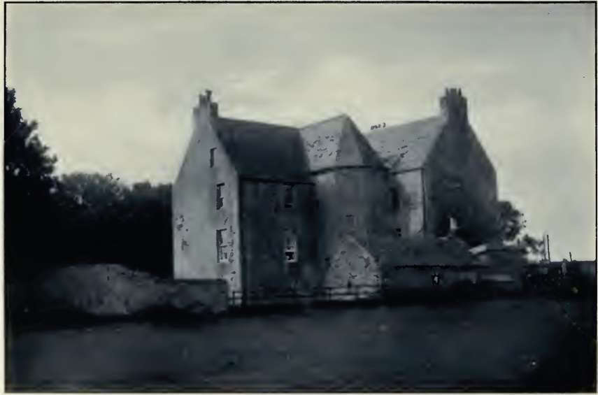
Bonhard Castle. (From
a photograph by Eric Jamieson, Bo'ness.)
us that, notwithstanding the old-world air about
the house, it is quite modern in its arrangements, and retains
none of the defensive features which frequently prevailed in
Scotland till a late period. Its walls are about three feet
thick, and the rooms are provided with fairly large windows. The
present entrance door in the south front is an old window opened
out to form a door. Of the L plan, the house has an octagonal
staircase turret in the re-entering angle, in which also is the
original entrance. The place is well worth a visit, and inside
there are some finely panelled ceilings and ornamental
fireplaces still to be seen.
Concerning the old dovecot, there is to be found
on its west gable, says the same authority, all the lettered and
heraldic history to be found at Bonhard of the Cornwall family.
Not much can be made out at first sight, but on a careful
examination the Cornwall arms impaled with the arms of a branch
of the Seton family can be satisfactorily traced, above which is
the motto, "We Beig, Ze. Se. Yarle " (We build, ye see, warily),
with the date 1591 and the initials N. C. & M. S. The N. C. has
been identified as the initials of Nicholas Cornwall, and the M.
S. represent those of his third wife, who was a Marie Seton.
Nicholas, who for a period occupied the position of Provost of
Linlithgow, died in 1607, aged seventy years.
Peter Cornwall, the father of Nicholas, built a
town-house in Linlithgow in 1527, and was the first to assume
the abore arms. The house was demolished in 1870, and among the
stones taken from it was one containing the date, the motto of
the Cornwalls, and a matrix for a metal plate. The plate
containing the arms crumbled away on being touched. Waldie8mentions
that it bore the device of a bird, with a stalk of corn in
its mouth, standing on the top of a wall. John,
the hero of the family, fell at Flodden. He was one of six who
were dressed up in the same style as the king, to whom he bore a
great resemblance.
The Cornwalls owned the lands of Flask, now
Springfield, and a large portion of Bonnytoun, and were closely
connected, civilly and ecclesiastically, with the royal and
ancient burgh. As Dr. Ferguson9 puts
it, a Cornwall was Provost of Linlithgow, a Cornwall was one of
the chantry-priests in St. Michael's before the Reformation, and
two Cornwalls are found among her Protestant ministers.
The ministers were Robert Cornwall and his son
John Cornwall, who died in 1646, after a service of twenty years
in St. Michael's. Robert had another son, who was minister of
Muiravonside.
But the family was also intimately associated
with our own town and seaport. There was a "Walter Cornwall of
Bonhard, who, in December, 1639, compeared before the Town
Council of Linlithgow, along with Mr. Richard Dickson, minister
of Kinneil, as a deputation from the Presbytery concerning a
matter in which the Rev. John Cornwall was involved. Then, in
1679, we find a James Cornwall of Bonhard appointed as one of
the special commission to try six persons in Bo'ness for
witchcraft. Again, a Walter Cornwall of Bonhard was appointed
bailie of the regality of Borrowstounness about the year 1692.
With Thomas Cornwall, his son, it would seem that the connection
of the family with the district ceased, and the house and lands,
along with those of Northbank, were acquired by James fourth
Duke of Hamilton in 1742.
VII.
On the shore at the eastern end of the parish
stands sentinel-like the old fortress of Blackness. Situated on
a rocky promontory, it projects into the Forth, and seawards
represents the hull of a ship. The chief part of the building is
a strong oblong tower or keep with a circular staircase tower at
the north-east angle. This staircase was probably added at a
date subsequent to the erection of the keep. The keep is still
preserved, although much altered, and stands detached, with a
considerable space of ground, surrounded with a strong wall. A
large part of the wall still remains, and has a thick parapet
with large portholes or embrasures for cannon cut through it
similar to those at Stirling. The other buildings comprise a
combination of old and new structures, and a sketch in the Royal
Scottish Academy shows the landward or south front, the interior
of which is seen as it now stands. The exterior has been
deprived of its parapet, and the walls are heightened and
covered with a plain roof.10 In
short, save for its ramparts and dungeons, the castle as we see
it is comparatively modern.
The powerful Douglases, who seriously menaced the
power of the King in the reign of James II., held the Castles of
Inveravon, Blackness, and Abercorn. But in one of the subsequent
raids on the Douglas lands Blackness Castle was destroyed. It
remained for a time ruinous, and by special charter in 1465 the
Burgh of Linlithgow—of which town in its palmy days Blackness
was the seaport— received power to demolish the ruin and utilise
the stones for the purpose of constructing a new port or pier at
Blackness. The hill and rock from St. Ninian's Chapel to the
sea, all round the promontory, were to belong in future to the
burgh. The principal reason for this grant, Waldie says, was the
" vexations, troubles, harassments, and extortions" formerly
practised by those who held the castle upon the merchants of the
burgh and others frequenting the port. It is almost certain,
however, that the burgh never entered into possession under this
charter. Besides, the grant was recalled by an Act of 1476
revoking all grants made in the minority of James III., and
especially of such places as were considered to be " keys of the
kingdom." The foundations of St. Ninian's Chapel are still
traceable on the top of the Castlehill.
An English fleet, in 1481, is said to have burnt
the shipping at Blackness, then a considerable seaport. The
castle, some think, was destroyed at this time also; but, if so,
it must have been quickly rebuilt, for in 1489 it was in use as
a State prison. Nearly sixty years after this—1548—during the
Regency of the Earl of Arran, it was for a time garrisoned by
the French. When the Queen Mother, Mary of Guise, was made
Regent the castle again came into possession of the French, but
in April, 1566, it was taken from them by the Sheriff of
Linlithgow. In February, 1571, it was manned with a garrison by
Lord Claud Hamilton, a zealous partisan of Queen Mary; and it
appears to have been held in her interest until February, 1573,
when it was delivered up to the Regent, the Earl of Morton.
During their occupancy the Queen's troops, it is said, made an
inroad upon the opposite coast, when they "spoulzeit" the towns
there, and returned to Blackness with considerable booty. On two
occasions during the same period an attack was made upon the
castle by the Queen's enemies within the realm. And we also find
at this time that a ship of war, well furnished with artillery,
was sent from Leith to "asseige" the castle, but was driven from
the station where she had cast anchor by the violence of the
weather. Once more an attempt was shortly thereafter made to
carry the place by surprise. It failed, however, as the garrison
was on the alert.
A rather tragic story of the castle is told in
connection with the betrayal of Sir James Kirkaldy by his wife
to the Regent Morton. Sir James, on arrival from France with the
arrears of the Queen's dowry, had been made prisoner by the
keeper of the castle, who, in his absence and unknown to him,
had gone over to the other side. While in prison Kirkaldy
managed to gain over the men, and keep the castle. His wife came
to visit him, and he was induced to accompany her for a short
way when leaving. He was then seized by the keeper of Linlithgow
Palace, who was waiting for him in hiding, and sent next day to
Edinburgh. Shortly after this he made his escape, and eight days
later his wife was found lying strangled in her bedroom.
Kirkaldy was executed the same year.
VIII.
But in contemplating the long history of the
castle—its many destructions and its many rebuildings, its many
owners and its many uses—the most vital memories circle round
the great; and successful struggle of our forefathers for
the-principles of civil and religious liberty. In the reign of
James VI. it was the principal State prison of Scotland. A& such
its dungeons confined many a godly minister and many
distinguished persons who were martyrs for the truth. In 1584
Andrew Melville was ordered to be " warded " here. He-had
disputed the authority of the King and his Council to-interfere
with the doctrines taught in a sermon he had delivered at St.
Andrews. After the warrant was served on him, however, he
escaped to Berwick.
During the same year the clergy in and near
Edinburgh were apprised that measures prejudicial to " the Kirk
and its-discipline " were to be resolved on at a meeting of
Parliament appointed to be held in May. They prevailed upon
David Lindsay, minister at Leith, who was most acceptable to the
Court, to intercede with the King for the interposition of his
authority till the Assembly should be heard'in the matter. When
entering the gate of the palace, in discharge of his-commission,
however, he was apprehended and carried to Blackness. There also
the ministers of Edinburgh were condemned to a temporary
confinement in 1587 for refusing to pray for Queen Mary.
In 1594 the Earl of Angus, one of the
excommunicated, lords, was required to deliver himself up to
custody in Blackness-till he should undergo a trial; but,
refusing, was subsequently with the others found guilty of high
treason.
From August, 1605, till towards the close of the
following-year John Welsh, minister of Ayr, who had married John
Knox's daughter Elizabeth, and five other clergymen,
were-confined in the castle for refusing to condemn the Assembly
that had met a short time before at Aberdeen in defiance-of the
King's command. Their trial took place at Linlithgow, where the
High Court of Justiciary had been temporarily-established, away
from the risings and troubles which such an occasion was sure at
that time to cause among the populace-of Edinburgh. After a
notoriously unfair trial the ministers.
b were
found guilty by the Court, and ' banished the King's dominions
upon the pain of death," but were re-committed to Blackness, for
a time at least. Welsh was courageously defended by Thomas Hope,
afterwards the celebrated Sir Thomas, who, in great contrast to
his contemporaries at the bar, was no truckler to the King.
Welsh is said to have thanked him in Court for his exertions,
remarking that he felt assured that Hope's posterity would rise
to the highest honours. The various descendants of Sir Thomas
Hope have long been large landowners in the county, and many of
them have held important positions in the service of the State.
About the same time a State prisoner of a
different description was lodged here for a few days pending his
transference to Edinburgh Castle. This was Gilbert Brown, Abbot
of New Abbey, described as " a trafficking and seducing Papist."
In 1624 William Rigg, one of the bailies of
Edinburgh, was deprived of his office of magistrate, condemned
to be imprisoned in Blackness Castle, and fined £50,000 Scots,
for challenging the doctrine taught by the Episcopal clergy. He
was charged with being the chief ringleader of the non-conformitants
in Edinburgh, and with contributing liberally to the printing of
books which crossed the course of "conformitie."
John Hamilton, second Lord Barganv, and at that
time possessor of Carriden estate, was also a prisoner there in
1679. His offence was that of entertaining notorious rebels in
his house and declaring that Scotland would never be well till
it was clear of Episcopacy. His trial, however, was never
brought on for want of evidence. Another sufferer was John Hay
of Lochloy, who was in 1683 committed prisoner for the space of
thirteen months, "pairtly in the tolbuith of Edinburgh and
pairtly in the Castle of Blackness." His offence was hearing the
nonconforming ministers.
Waldie relates that, after his victory at Dunbar,
Cromwell, on his advance towards Stirling, made some
fortifications at the palace at Linlithgow, and that Blackness
Castle surrendered after a short siege in April, 1651. Lord
Ochiltree, found guilty of accusing the Duke of Hamilton of
treason, lay a prisoner there from 1631, and was one of those
released by Cromwell's Government after the battle of Worcester.
The cell in which he was so long imprisoned can still be seen.
Waldie further states that, according to one record, the castle
was "blowne up with a powder traine" on 3rd April, 1652; and he
remarks that at its upblowing the devil was seen on its walls.
Very congenial to the devil of popular estimation was this kind
of work.
Before this time, however, Blackness had become a
busy seaport and mart of, trade, intimately connected with the
county town. It had a large Custom-house, was the centre of a
considerable population, and had in its neighbourhood mills,
fisheries, coal works, and saltpans. But its seaport and
industries have long since ceased to be, and the place is now a
modest yet popular summer resort. The castle is in use as a
Government military store, under the charge of a military guard
from Edinburgh Castle.
IX.
What really led to the decay of Blackness in the
seventeenth century was the sudden rise of Borrowstounness, "the
town on the Ness," as it was called in its early days to
distinguish it from the original "town" of the district, the
village of Kinneil. We often hear Bo'ness described as "our
ancient town," but this is not correct, for, despite its
ancient-like appearance in places, it is far from being old,
comparatively speaking. In fact, so far as the records show, it
cannot be more than three hundred and fifty years old. We begin
to trace mention of it about the end of the sixteenth century
and the beginning of the seventeenth. Sibbald, speaking of its
sudden rise, tells us of Sir Robert Drummond of Meidhope (Midhope,
near Hopetoun), an old laird who lived till after the
Restoration (1660). This gentleman, in his old age, was in the
habit of telling several of his neighbours that he well
remembered the time when there was only one house where
Borrowstounness and Camden then stood. But whose house it was,
or where it was situated, we are afraid cannot be discovered
now.
By oral tradition we have it that the first
settlers were fishers, sailors, and miners. Narrow as the space
of flat land along the shore now is, it must have been much
narrower in those early days, as the foreshore then lay along
the north side of the present North Street. The small
building-space thus available on the low or shore ground would
account for the irregularity of the early buildings. Houses and
huts were evidently put up wherever a spot of ground could be
conveniently got. Some of us can remember that many of the old
houses, not so long ago demolished, were under the level of the
street. This would come about when the shore-ground to the north
of them was reclaimed and made up, very likely to a considerable
height, above the original level of the ground on the shore
border, where the first houses were erected and a street was
formed. A jocular reason used to be given for the houses being
below the street level. The sailors were so much accustomed
going below to their cabins that they preferred to get to their
houses by a similar process, and built them accordingly. One
candid writer has told us, and truly, that the town is very
irregularly built, contrasting unfavourably with the beauty of
the situation. In modern descriptions of it we are usually
informed that it contains two principal streets, which are
narrow, running from west to east for a considerable distance,
and converging in one. An early record describes it as a long
town consisting only of one street, extending along the shore
close to the water, and we have no doubt this accurately
described the town in its early years.
It is said to have derived its name from the old
village of Borrowstoun, situated on the high ground about a mile
to the south on the turnpike road to Linlithgow, and still in
existence. Borrowstoun, again, is thought to have meant the town
of the borough as being in the vicinity of Linlithgow, the
county town. Ness, of course, signifies a naze or point of land
projecting into the sea, and, if we look at the configuration of
the coast, the projecting naze is yet quite discernible.
The early settlers, as we have indicated, seem to
have had little idea of architectural beauty or arrangement, and
huddled the houses together. In many cases encroachments in the
shape of outside stairs and porches were made on the
thoroughfares, thereby making it a very difficult and costly
task to accomplish the improvements which had to be undertaken
by the Local Authority from time to time in later years. Many of
the houses were built gable-on to the sea, a practice common in
most seaport towns, and several typical instances of this are
yet to be seen both in Borrowstounness and Grangepans.
X.
Mr. Johnston, writing of the "auld-warld " look
of the town, suggests that a painter with an eye and a taste for
the antique in urban architecture might do worse than try his
brush in this quarter. Here he would find some streets narrow
enough and tortuous enough and erratic enough to be at once
accepted as fit for reproduction on his canvas. He would here
discover no lack of strange nooks and corners, and see houses in
plenty that have all the quaint characteristics so beloved of
artists. This was said in 1890; and before the wholesale
demolitions which took place in 1902 in the heart of the town,
it is gratifying to know that several artists made numerous
water-colour and other sketches of the neighbourhood, and
especially of its older quarters. These therefore will long
preserve for many of us and our successors the quaint and "auld-warld"
features of the seaport.
To what individuals or influences, local or
external, Borrowstounness owed its somewhat sudden start in life
it is difficult to say. It is not likely that the Forth herring
fishing, which at a later date was very successful for a time,
was one of these. Nor do we think the quest for whales had then
become a craze with the inhabitants. What seems more likely to
have contributed to its rise was the presence in the
neighbourhood of the shore of an abundance of coal. Coal had
been discovered in the district some centuries before, but it is
evident that about the time we are writing of it was being
wrought, not, perhaps, at a great depth, but still fairly
extensively, by the Hamilton family or their lessees, in what
was known as the coal-heugh of Borrowstounness.
The young town had the advantage of a natural
harbour or creek, which was situated practically in the vicinity
of the present harbour. There was then neither west nor east
pier. Vessels were simply loaded and unloaded at low water by
means of a causeway run out into the mud, the remains of which
were discovered when enlargements and improvements at the
harbour were being made long years after. Coal and salt were
among early exports, chiefly to Holland and the Baltic. When the
Union of the Crowns took place, in 1603, a great impetus was
given to the commerce of the country, on the east coast, at any
rate, and the infant port evidently shared in it. This
prosperous trade induced a number of rich merchants from the
west country, shipowners and others, who saw possibilities of
great developments in the place, to acquire property or to
reside here. The town and population therefore rapidly
increased. These were the days, of course, when Glasgow and the
Clyde had not yet indicated anything of their coming commercial
magnitude, and when a Glasgow Customs officer was appointed to
Bo'ness "on promotion." |
|

