|
The name of Caithness is
derived from the old Norse. It indicates the ness, naze, or nose of Cattey.
Many of the headlands are also denominated ness, from Brim’s Ness to the
west of Thurso, to Noss Head north of Wick. Indeed, the same word is applied
to headlands along the east coast of Scotland and England—from Tarbat Ness
in Boss to Dungeness in Kent. The same word is applied to the Naze in Norway
and in Essex, and to Cape Gris Nez (Gray Nose) near Calais. It usually
indicates a headland which the Scandinavians have named, or near which they
have settled.
Caithness seems to have been
almost entirely Scandinavian. The creeks or bays in which the Norsemen
anchored, or where they ran their boats ashore, are called by Norwegian
names, from Wick, the greatest fishing station in the world, to Freswick,
Sleswick, Dwarwick, and such like inlets.
The Gaels seem to have been pushed inland towards the hilly country of
Sutherland, while the Scandinavians occupied the low-lying ground along the
coast. Almost every farm steading is called by a Scandinavian name. Hence
Scrabster, Lybster, Seister, Thurster, Ulbster, and such like—the word ster
being from “saetr,” the Scandinavian word for farm. Dahls, or dales,
penetrate the country to the southward, though the Celtic word Strath is
still preserved. Hence Strath Halladale and Strath Helmsdale in
Sutherlandshire. North of that region, the rivers are called forss or water.
Worsaae derives the name of Thurso from Thor the pagan god, and aa a river.
Hence Thorsa, or Thor’s river.
The people also resemble their progenitors. The fair hair, blue eyes, and
tall figures of the Scandinavians are still preserved throughout the
county,—in contradistinction to the small size, the dark hair, the swarthy
skin, and the black or steely-blue eyes of the Celts, to the south and west
of Scotland.
All the firths, or inlets of the sea, are known by Norse names. The Pentland
Firth, which runs between the north coast of Caithness and the Orkneys, was
in old Norse called the Petland Fiord. Here we have the mythical Picts
again. Bleau, in his Geographical Atlas, says that the Piets, when defeated
by the Scots, fled to Duncansby, from whence they crossed to Orkney. But,
meeting with resistance by the natives, they were forced to return. On their
way back to Caithness, they all perished in the firth; from which
catastrophe it was ever after called the Pictland or Pentland Firth.
Heavy currents run through the Firth. The tide runs at the rate of ten miles
an hour. A full-rigged ship, with her sails set and a favourable wind, is
sometimes driven back by the tide. This I have seen when journeying along
the shores of the Firth. Sometimes it is whirled round amidst the eddying
currents. Where the currents of the Atlantic Ocean and the North Sea meet,
the water is churned and eddied about as in a maelstrom. At the east end of
the Firth is the island of Stroma, which in old Norse means “ the island in
the current.” The population of the island is of pure Norwegian descent; the
men being excellent sailors and boatmen.
Not far from this island, and in sight of John o’ Groat’s, are the two
Pentland Skerries, commanding the eastern entrance to the Firth. They were
originally called Petland Skjaere. The largest skerry contains two
lighthouses, one higher than the other, to be a surer guide to the mariner.
During the equinoctial gales, the wind sweeps across the county with great
fury. It is scarcely possible to hold one’s feet. Cattle are blown down, and
trees are blown away. The thatched roofs of the cottages are held down by
strong straw ropes with heavy stones hanging at their ends; otherwise the
roofs would be blown away, as well as the cottages themselves.
It is scarcely possible to grow a tree in the northern part of the county.
Hedges are almost unknown. Instead of hedges, the fields are separated from
each other by Caithness flags set on end. To one accustomed to the beautiful
woods and hedgerows of the south, the cheerlessness of Caithness scenery may
well be imagined. Robert Chambers said of the county—“ The appearance of
Caithness is frightful, and productive of melancholy feelings.” “It is only
a great morass,” says another writer; “ the climate is unfavourable; the
stormy winds are always blowing across it; mists suddenly come on, and the
air is always damp.”
A desperate effort has been made to grow trees at Barrogill Castle, within
sight of the Pentland Firth. A wood surrounds the east side of the castle.
The trees are planted thick, and they are protected by a high wall. But at
the point at which the wall ends, the tops of the trees are sharply cut away
as if by a scythe. They are chilled and eaten down by the sea-drift.
The best wood in the northern part of the county is at Castlehill, where the
imported trees are protected by rising grounds on all sides. The only tree
that thrives in Caithness is the common bourtree or elder. The trembling
poplar, the white birch, and the hazel, are also occasionally found in
sheltered places.
But though the county of Caithness is for the most part flat and cheerless,
it is redeemed from monotony by its glorions coast scenery. On the east, as
well as on the west, the rocks jut out into the ocean in stupendous cliffs.
“When the stormy winds do blow” is the time to see the wonders of the
north—at Duncansby Head, at Dunnet Head, at Holborn Head, at Noss Head, and,
indeed, all round the coast. At Wick Bay, only a few years ago, a tremendous
storm from the east dashed to pieces the new breakwater, lifting up stones
of tons weight and dashing them on the beach,—thus setting at defiance the
skill and ingenuity of the engineer who had built it.
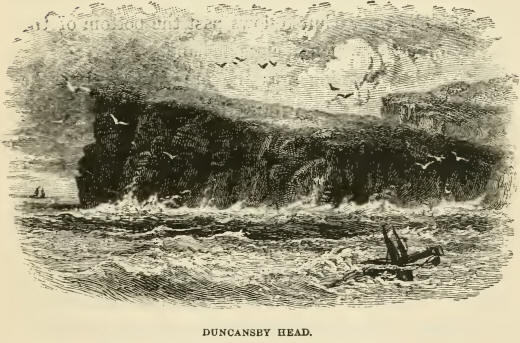
Duncansby Head is also exposed to the full fury of the North Sea. It is a
continuous precipice about two miles in extent, and of a semicircular shape.
It is remarkable for its stupendous boldness, and the wild and striking
appearance of the chasms and goes by which it is indented. In front of the
cliff are three Stacks, which have been washed round by successive storms,
and stand out bare and red several hundred yards from the mainland. The
cliff consists principally of old red sandstone, and partly of Caithness
slate.
The huge, long, white-crested billows, lashed into fury by the storm, chase
each other up the beach, and burst with astounding force. At high tide, they
dash up the cliffs and rush over the summit into the mainland. Fiom thence
they run down over the inland slopes, into a rivulet which joins the
Pentland Firth near John o’ Groat’s. From the summit of the cliff a fine
view is obtained of the Skerries at the mouth of the Firth, of Stroma, the
island in the current, and of the Orkney Islands as far as the bold headland
of Hoy.
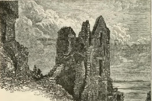
Along the east coast, numberless castles are built upon the cliffs. They are
mostly in ruins. Many ol them are prehistoric. Wick Castle, Girnigo Castle,
and Keiss Castle, are the oldest. Ho one knows who built them. Most probably
they are the strongholds of the Scandinavian chiefs, who, at some unknown
period, took possession of the lowland part of the county.
The castle of Al-Wick—or, as it is usually called, the Auld Man of
Wick—seems to be one of the most ancient. It consists of a grim-looking
tower or keep of the rudest masonry, perforated here and there with
arrow-slits. It is three stories high; but entirely roofless and floorless.
It is surrounded by an outer wall, within which are the ruins of some old
houses. A deep broad moat defends it on the land side. At present, it forms
an excellent landmark to vessels approaching that part of the coast.
Girnigo Castle, situated on the promontory of Hoss Head, is also very old.
Castle Sinclair, which was added to it, has a history, which Girnigo has
not. But the old builders were so much better than the new ones, that while
Castle Sinclair has fallen to ruins, Girnigo Castle stands as firmly as it
did at the time at which it was built.
The constantly rolling sea, ever for ever, washes itself against the rocks,
grinding away the softest parts. The red sandstone goes first, leaving long
hollows amongst the slates, through which the sea drives inland. In stormy
weather, the waves wash in with
great force, sometimes a quarter of a mile or more; and at theS~^ far end,
they drive up into the open air, blowing like a whale. '
These hollows under the rocks are called goes or gyoes. They are common V
all round Caithness. One of them is near Wick, at the castle of Al-Wick.
Girnigo castle.
Robert Dick describes another
near Thurso, which will be found referred to in a future part of the story.
From the northern part of
Caithness, where the >N11 ground is comparatively flat inland, and full of
lochs from Thurso to Wick, the land gradually ascends, until we find hills
and then mountains close upon the borders of Sutherland. Morven, Maiden Tap,
and Skerry Ben, form part of a range of mountains, extending from Sandside
Bay on the north, to Helmsdale on the south. Morven is the great mountain of
Caithness. It is 2331 feet high. It is regarded as the great weather-glass
of the county. When the mist gathers about its base, rain is sure to follow;
but when the mist ascends to the top and disperses, leaving the majestic
outline of the mountain exposed to view, then the weather will be fine.
“During harvest especially,” says a local writer, “all eyes are directed
towards it; and it never deceives.
“In vision I behold tall
Morven stand,
And see the morning mist distilling tears
Around his shoulders, desolate and grand.”
From what we have already
stated, it will be understood that Caithness is by no means a fertile
county. Until a comparatively recent period agriculture was in a very
backward state. When Pennant visited the county about a hundred years ago,
he describes it as little better than “an immense morass,” with here and
there some fruitful spots of oats and bere, and much coarse grass.
In those places where any agriculture was carried on, the women did the work
of horses. They carried the manure on their backs to the field; and did the
most of the manual labour. The land could scarcely be called ploughed. The
Caithness plough was one-stilted. It was dragged over the ground by a yoke
of oxen, driven by a woman. There were neither barns nor granaries in the
county. The corn was preserved in the chaff in bykes, which were low stacks
in the shape of bee-hives, thatched quite round.
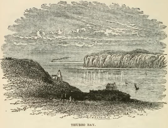
Thurso, the chief place in Caithness, carried on a trade with Norway and
Denmark, long before it began to communicate with the rest of Scotland. The
sea was by far the easiest mode of transit; and all the people along the
coast were sailors. But, indeed, there was very little traffic to be carried
on. The only two clusters of houses in the county were Thurso and Wick.
Thurso must have been the more important place, as it not only had a church,
but also a bishop— the Bishop’s Palace being close at hand. Thurso was a
small fishing town, and Wick contained only a few hundred inhabitants. But
the fishing has long left Thurso, and gone to Wick. “The only fishing at
Thurso now,” said Dick, “is sillocks and sillock scrae. The salmon fishing,
however, is the best in the kingdom.”
There were then no roads in Caithness. The extensive hollows in the flat
slaty ground were filled with morasses. There was not a single wheel-cart in
the county before 1780. Crubbans were the substitutes for carts. They were
wicker baskets. Two of them, hung one on each side of a pony from a wooden
saddle, beneath which was a cushion of straw, carried corn, goods, and other
articles. Six or seven ponies thus loaded, says Henderson in his
Agricultural Survey of Caithness, might be seen going in a kind of Indian
file, each tied by the halter to the other’s tail, a person leading the
front horse, and each of the others was pulled forward by the tail of the
one before him. Yet traffic was carried on throughout England in the same
manner, about three hundred years ago.
Caithness was behind in everything. The only geography of the county was
known from Danish sources. Timothy Pont made his first map in 1608. It was
shut out from the rest of Scotland by the mountainous county of Sutherland.2
It was long before a road could be made to enable the people to communicate
with their countrymen farther south. The only road lay along the eastern
shore, among rocks and sand, which were often covered by the tide. The
inland road lay over the Ord of Caithness. The Ord is a formidable pass
between Sutherland and Caithness. It is situated at the eastern boundary of
the two counties. There is a lofty mountain on one side of the road, and a
steep precipice on the other, at the foot of which is the sea.
The Ord is the termination of a long mountain ridge, and is the brow of a
steep hill overhanging the ocean. On the Sutherland side, the headland is
cleft into a gorge of great depth, which runs a long way inland. The old
road—before the present bridge was built over the gorge —was a mere path or
shelf along the outer edge of the promontory twelve hundred feet above the
sea. When
the weather was stormy, it could not he passed in safety. Even in fair
weather, the road was so difficult and dangerous that, when the chaise of a
landed proprietor had to pass it, a force of fifteen or twenty persons was
employed to help on the carriage and horses.
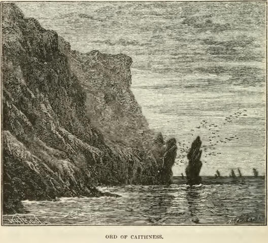
Pennant, who travelled into
many strange places, described the pass as “infinitely more high and
horrible than Penmaenmaur in Wales and another writer says, J that if any
stumble thereupon, they are in danger of falling down a precipice into the
sea at the bottom of the rock, which is very terrible to behold.” The old
path is still to be seen from Helmsdale. It is like a sheep-track winding up
the steep brow of tlie hill, some three or four hundred feet above the
rolling surge.
The road to Thurso from the Ord road was almost impassable. It was a mere
horse track over the hill of Bencheilt. This road was made passable for
carriages through the energy of Sir John Sinclair. The Abbe Gregoire
denominated Sir John “the most indefatigable man in Europe.” To him the
improvement of the county of Caithness in a great measure belongs. He was
born at Thurso Castle, an ancient edifice built by the' sixth Earl of
Caithness. It has since been pulled down to make room for a spick-and-span
new castle, much less picturesque than the old one. It stood almost 'within
sea-mark on Thurso Bay. In stormy weather, the sea spray sometimes passed
over the roof. Miss Catherine Sinclair has said that fish have been caught
with a line from the drawing-room window; and vessels have been wrecked so
close under the turrets, that the voices of the drowning sailors have been
heard.
When Sir John succeeded to his estates, three-fourths of Caithness consisted
of deep peat-moss, and of hills covered with heath, or altogether naked. On
arriving at his majority, he determined upon the improvement of his estates,
and of the county generally. One of the first things that he did was to
endeavour to make a roaci to Thurso over Bencheilt, in the centre of the
county. He himself surveyed the road and marked out its lines. He called
together twelve hundred and sixty labourers to meet him early one morning,
and set them all simultaneously to work. They began at the dawn of day, and
before nightfall, the sheep-track, six miles in length, was converted into a
road perfectly easy for carts and carriages. This showed what energy could
accomplish.
The young laird was not satisfied with that. He formed a large number of
farms on his own estate. He enclosed, drained, and reduced them to order,
entirely at his own expense. He built bridges; he made roads; he introduced
the best cattle; he provided the best turnip, rye-grass, and clover seeds;
he enjoined upon his farmers to adopt a regular rotation of crops; and in a
short time converted what had been a barren wilderness into a
well-cultivated district. He enclosed on his own estate about 12,000 English
acres of waste land, all of which eventually repaid the outlay. Among his
other achievements, he introduced the Cheviot breed of sheep into the whole
of Scotland, and thus doubled the value of the grazing grounds north of the
Tweed.
Sir John tried to introduce trees at Thurso, but he found it difficult to
make them grow. It was necessary to dig a hole of large dimensions through
the subsoil of slaty rock, over which the tenants of the neighbouring
townlands were obliged annually, for seven years, to heap a large mound of
compost. And even when the trees did grow they were often blown away by the
furious winds from the north and west.
Sir John even tried to introduce nightingales into Caithness! But Nature
baffled his efforts. He obtained nightingales’ eggs from the London bird
fanciers. They were substituted for those of the robin redbreast. The eggs
were hatched. The young nightingales soon flew about the bushes round Thurso
Castle. But so soon as the summer had ended, the birds disappeared and never
returned.
|

