|
The surface of Forfarshire is highly diversified : it contains
within its bounds districts that are highland, others that are
lowland, and yet others that are maritime. In the north extend in a
north-easterly direction the Grampian mountains, which rise ridge
upon ridge from the Braes of Angus, their southern spurs, until they
attain on the county march their highest general elevation of more
than 3000 feet. With a breadth varying from 9 to 15 miles, they
stretch for 24 miles through our county, where they are sometimes
known as the Benchinnin mountains. A parallel expanse of lowland
country to the south-east, 32 miles by 4 to 6 miles, is the fertile
Howe of Angus, a portion of Strathmore. There follows, as we advance
southwards, another parallel
section, the Sidlaws, with their eastern
and north-eastern spurs, a range from 3 to 6 miles broad and 22
miles long. The maritime district succeeds this, curving round the
southern and eastern parts of Angus in a belt 37 miles by 3 to 8
miles.

The highland district
is the largest and most picturesque. It occupies at least two-fifths
of the whole shire. Through it various glens run from north to
south, the chief being Glen Isla, Glen Prosen, Glen Clova, and Glen
Esk. At the heads of these valleys rise the highest summits of the
county, while their dividing ridges attain a scarcely lower
altitude. The giant Glas Maol (3502 ft.) towers above the infant
waters of the Isla. A particularly shapely, though less ambitious,
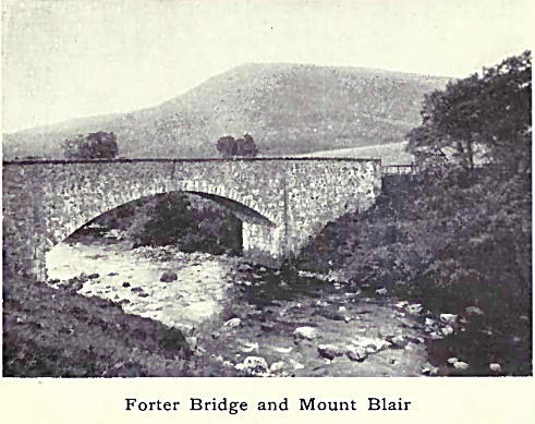
hill, Mount Blair (2441 ft.), commands one of the most extensive and
varied prospects in Scotland, and buttresses Glen Isla on the west.
Ban-noch, Broad Cairn, and others on this part of the county march
look down upon the sullen waters of Dubh Loch, a deep mountain tarn
in Aberdeenshire directly under “dark Lochnagar.”
The Prosen finds its source in Mayar
(3140 ft.); and Driesh and other heights separate its glen from that
of Clova. Cat Law (2214 ft.), to the south-west of Prosen and Clova,
has a wide prospect extending in clear weather almost from Stirling
to Stonehaven.
Next come two minor
glens, Glen Ogil with the Noran and Glen Lethnot with the Water of
Saughs, lower down called West Water. To the north the broad expanse
of the Wirren (2220 ft.) shuts in the valley of the North Esk on the
south and gives it its final eastern trend. This is a fine hill. Its
ample green slopes, indented with many a mountain stream but
unscarred by these, seem to breathe peace.
On the north and east
of Glen Esk there curves a noble series of rounded heights, almost
matchless in the county for rugged grandeur. The Mark and the Tarf,
two tributaries of the North Esk, each with its own glen, descend
from the frontier heights. Conspicuous amongst these are Mount Keen
(3077 ft.), Hill of Cat, and Mount Battock (2555 ft.), on whose
summit three counties converge.
Forfarshire can
scarcely vie in its highland scenery with western and northern
Scotland. In general shape its mountains are oblong, rounded, or
flat-topped. These tame braes and knocks and meals and shanks
usually command vast expanses of heath-clad or barren plateaus,
above which in unimpressive bosses project their loftier summits, or
a sea of mountain billows severed by characterless depressions. But
to this there are exceptions. If on a smaller scale, there are
precipices and peaks that recall those of Glencoe, and corries and
tarns as desolate as any in the Cairngorms. Such are Caenlochan, a
sublime corry that gashes the north-eastern shoulder of Glas Maol;
Craig Rennet, that soars like an Alpine precipice 1000 feet sheer
above the White Water of Glen Doll; and the serrated cliffs of Craig
Maskeldie overhanging the tarn of Carlochy high above Loch Lee.
Strathmore, or the
Howe of Angus, as the Forfarshire portion of it is called, is a fine
expanse of fertile land in the heart of the county. It is not flat,
but diversified by numerous eminences. Many of these are isolated,
while others extend in more or less continuous mimic ranges. On the
whole they belong either to the Braes of Angus or to the Sidlaws.
Amongst the former are the Hills of Kingoldrum and Kirriemuir, and
the White and the Brown Caterthun ; amongst the latter, the Hills of
Kin-nettles, Finhaven, Turin, Balmashanner, and Dunnichen. Some are
wooded, and within their bounds flow tiny streams through lateral
valleys. The strath contains a series of small lochs which add much
to the attractions of the landscape. No finer view of the Howe of
Angus can be obtained than that from a point about two miles to the
south-west of Forfar on the Dundee road. The peaks of the distant
central highlands of Perthshire—Ben Lawers, Schiehallion, Ben-y-Gloe,
and the entire Ben-chinnin range from Glas Maol to Mount Battock,
stretch in clearly defined outline along the west and north ; the
gentler heights of the Sidlaws extend in finely marshalled array to
the south-west; and the wide strath with its fields and lakelets,
its hills and woods, its villages and towns, is unrolled in the
foreground and to right and left.
The next district
takes its character and its name from the Sidlaw Hills. Starting
from Kinnoull Hill, these hills enter Angus at Gask. Many of their
most picturesque, though not their loftiest summits, are already
passed before the bold cliffs of Lundie, whose surrounding woods are
jewelled with lochs, the tower-crowned Kilpurnie, and the wooded
hill of Auchterhouse (1399 ft.) are reached, and the greatest height
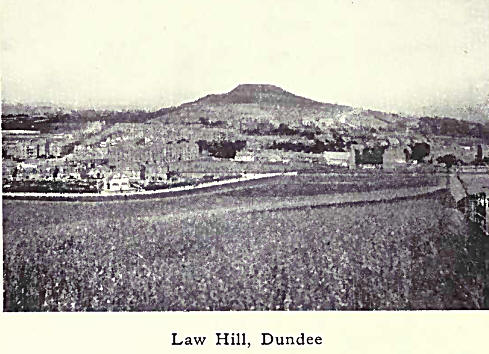
of the entire chain is attained in Craigowl (1493 ft.). Seen from
the opposite shore of Fife, this last mountain appears to dominate
the. whole district and forms a grand background to the city of
Dundee, on which the nearer cone-shaped Law Hill looks down. Between
these two there stretches from east to west the fertile district of
Strathmartine.
Three fairly well
marked ridges strike outwards from the neighbourhood of Craigowl :
one may be traced in the succession of heights, many of them wooded,
that descend to the coast near Monifieth ; the central ridge
broadens out to north and south as it advances eastwards to the
cliffs at Arbroath and the Red Head near Lunan Bay; and the third
and highest extends eastwards to the South Esk, whose valley it
bounds on the south all the way to Montrose.
Maritime Forfarshire
is that portion of the county which lies between the Sidlaws and the
Tay or the ocean. From the western marches to the mouth of the North
Esk, a line traversing this region and parallel to the coast is
about 37 miles long. This district is widest in the west and narrows
as the hills approach the sea in the east. The ground undulates and
rises not infrequently into knolls and even hills, many of which are
planted with fine woods. Near the sea, between Broughty Ferry and
Arbroath and again between the mouths of the two Esks, there are
wide expanses of downs or links. The links are valuable for grazing,
and for their numerous rabbit warrens. In certain parts they have
been laid out as golf courses, of which those of Monifieth, Barry,
Carnoustie, Elliot, and Montrose are noteworthy. |

