|
By far the greater number of visitors to Iona spend only a
few hours on the island, and as a rule their time is fully occupied in the
inspection of the antiquities described in the previous chapter. Full of
interest as these are, people whose attention is thus confined are apt to
carry away an impression not so much of the Iona of Columba as of the
mediaeval Iona, in the relatively uneventful era of the Benedictine
occupation. “It is rather the fair sea-beauty and imaginative charm of the
place that links us with the ancient, simple days of material poverty and
spiritual fruitfulness”, says Trenholme; and in order to get at this Iona,
it is essential to make a stay on the island. This is not a difficult
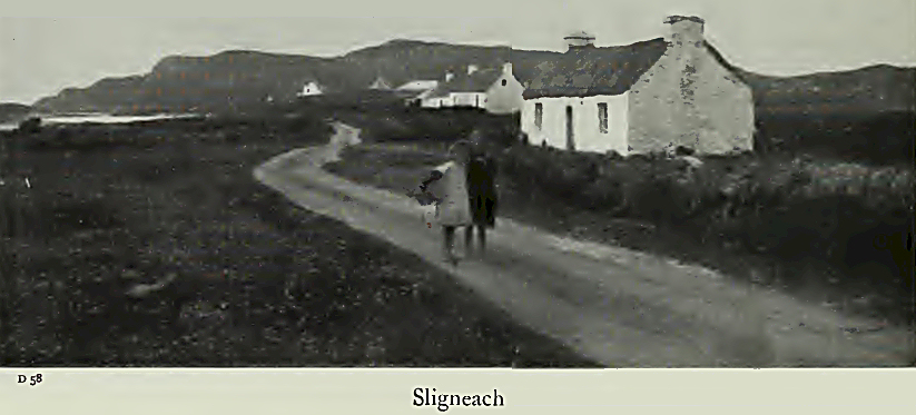
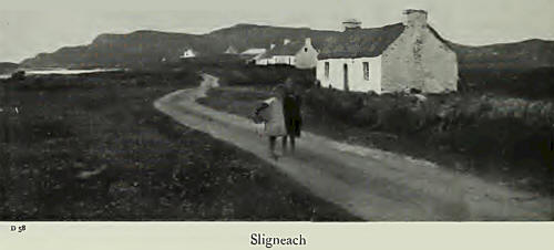
matter, for there are two comfortable inns, of a character harmonious with
their surroundings, and most of the cottages make provision for visitors. A
few houses, in addition, are to let for the summer months.
This chapter is specially intended for those who have leisure
to appreciate the manifold attractions of the little island. It is not
within the compass of a small handbook to deal in a detailed way with even
the history and antiquities of the island, much less its geology* natural
history, and other aspects. The specialist will have recourse to the
standard authorities, and for others who desire to extend their knowledge in
any particular aspect, a small bibliography is appended.
With leisure, the imaginative will be able to linger in the
quiet places beloved of Columba and his followers, and to spirit themselves
into the dim past; the artist will discover the beauty of the atmospheric
effects; the antiquarian will find fresh fields of interest; the
nature-lover will be absorbed in the varieties of bird, and flowrer, and
stone; the rambler can wander at will over moorland and rock and sheeny
sand; and many pleasing trips can be made to the entrancing islets that
surround Iona.
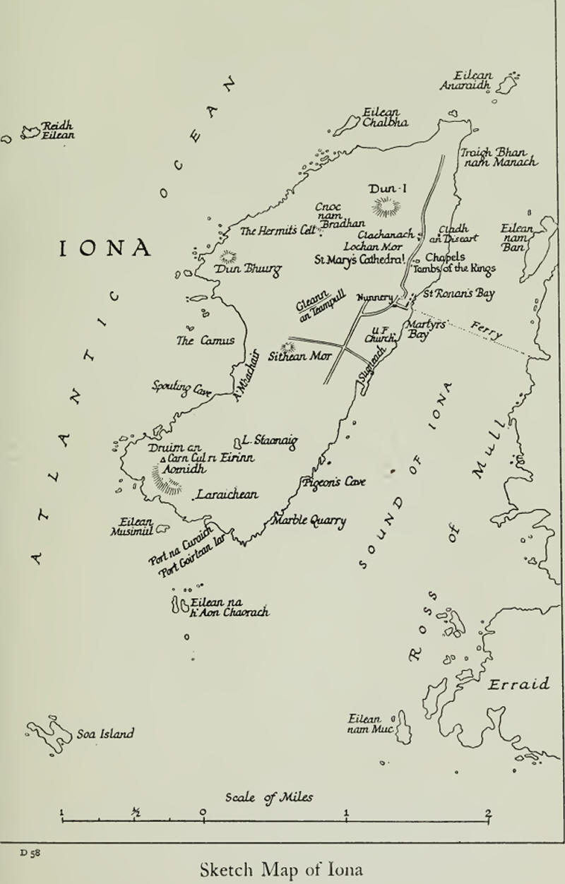
In this chapter, the places of special interest in Iona will
be enumerated and briefly annotated. Beginning just north of the Cathedral,
the route followed will run roughly in a counter-sunwise direction.
Site of Columba’s Monastery. From a piecing of evidence (see
Trenholme: Story of Iona) it has been determined that the tract of ground
lying immediately to the north of the Cathedral, and inclining to the
seashore, with the Lochan Mor on the west, the mill-stream on the south, and
the stone Blathnat probably indicating its northern extremity, was the site
of the monastery erected by Columba, over thirteen hundred years ago. The
remains of a line of earthworks may be seen between the mill-stream and the
house Clach-anach, on the west side of the road, and another section
formerly extended behind Clachanach, where the last piece of it was levelled
in 1906, in order to build an addition to the house. These appear to be
traces of the vallum mona-stern mentioned by Adamnan. The section between
the mill-stream and Clachanach may, it is thought, be partly natural, or
perhaps a prehistoric bit of fortification.
(During the excavations at Clachanach, there were found the
bones of a small horse that in some past age had been buried with laborious
care, six feet deep in the embankment. All but a tooth was restored to the
earth. It is thought possible that these are the remains of the white horse
in memory of which a wayside cross was erected on the spot where it took
leave of Columba.)
The monastic buildings, the character of which is described
in the fourth chapter, would be ranged within this enclosure, on the slope
towards the shore, and Columba’s house, which Adamnan describes as built “in
a somewhat higher place ”than the other cells, is thought to have been
somewhere near Clachanach; while “the little hill over-looking the
monastery” which Columba ascended to give his last blessing to the island,
is probably one of the two hillocks just behind the croft.

The Lochan Mor (the Great Pond), now drained to a bog, was
originally the monastery mill-pond, and from it the Mill-Stream still
trickles along its deep bed just north of the Cathedral to the sea-shore.
Adamnan mentions a kiln and a granary in the proximity of the monastery and
Pennant in 1772 saw by the mill-stream “the ruins of a kiln” (for drying
corn) “and a granary; and near it was the mill”. Traces of buildings still
remain on the high road by the mill-stream, west of the road.
Iomaire An Achd (Ridge of the Act). A little north of
Clachanach, immediately east of the road, and almost obliterated by it,
there is a mound where, according to local tradition, the monks used to meet
in council. “Perhaps”, says Trenholme, “the convention of the elders sat
there who chose St. Aidan from their number for the English mission, in the
year 635, as described by the Venerable Bede.” Such council hills were a
feature of the Celtic and Scandinavian civilization of these times.
The Stone Blathnat. Midway between the Ridge of the Act and
the seashore, there lies a great flat boulder — 27 feet by 18 — of red
granite, now grey with lichen. This stone is a relic of the great ice age,
but it has an additional interest. An eleventh-century scribe, in a preface
to Columba's great hymn: “Altus Prosator”, speaks of “a certain stone that
was in the monastery, Blathnat its name, and it still exists, and upon it
division is made in the refectory”. According to another scribe, “luck was
left upon all the food that was put thereon”. There is every reason to
identify the great boulder with the stone of the old Irish documents, and it
therefore marks the site of the refectory, which was probably built over it.
Cladh an Diseart (Burial-ground of the Hermitage) or Cladh
Iain (St. John's Cemetery). In a lonely spot a little south-west of the
stone Blathnat are two rough granite pillars, which, with a third stone that
lay across the top, formed a rude gateway to what was formerly a small
enclosure. In 1880, excavators discovered here the foundation of a hermit's
cell of the oblong type, 26 feet by 17, facing due east, and having traces
of an altar-piece at the east end. These “disarts” or hermitages were built
sometimes in solitary places, sometimes in the neighbourhood of a monastery.
The hermits spent their time chiefly in prayer and contemplation, and were
frequently sought as spiritual advisers. They studied also, and worked at
handicrafts, like other monks.
A hermit was usually buried in or near his cell: hence the
name of the ground adjoining this disart.
The Causeway (lomaire an Tachair, Ridge of the Causeway),
or Bishop's Walk, is an ancient roadway, 22 feet wide, and 220 yards long,
built high above the Lochan Mor. Skene suggests that it was constructed by
Cillene Droiteach (Cillen the Bridgemaker), the fourteenth Abbot, as a means
of^communi-cation between the monastery and the Hermit's Cell in the wild,
north-west tract of the island. Traces of a roadway connecting the Causeway
and the Cell are still to be seen.
The Hermit's Cell lies deep in turf and heather, a few yards
south-west of Cnoc nam Bradhan (Hill of the Querns). Only the foundation, on
which stones have been piled, is left. It is almost circular in shape, and
about 18 feet in diameter. The Gaelic name, Cobhain Cuildich, is popularly
translated Culdee Cell, but this carcair—so the Irish call the beehive hut
of a hermit—is probably of much greater antiquity than the Culdee order. It
is possible that the above-mentioned Cillen, who was an anchorite abbot,
ruled the monastery from this spot, and Skene thinks that it may have been
originally one of Columba’s prayer places. “Its position looking out over
the ocean to Tiree”, says Trenholme, “suits Adamnan’s description of the
place among the bushes, remote from men, and meet for prayer, where Columba
went to pray one day and beheld (perhaps in a storm of thunder and
lightning) hosts of demons fighting with darts in the sky, above Iona, but
at last driven off to Tiree.”
Traces of a walled walk, ascending to and enclosing the
hillock, are mentioned in the Statistical Account published a hundred years
ago, but the last vestiges seem to have disappeared.
Well of the North Wind (Tobar na Gaoith Tuaith). This is one
of the magic wells of antiquity. It lies north of Cnoc nam Bradhan, not far
from the Hermit’s Cell. Here, in olden times, sailors and others brought
offerings to charm up a wind from the north. A well of the south wind
traditionally exists in Iona, but can no longer be traced.
Dun-I (Hill, or Hill-Fortress of I), the one hill of Iona,
lies immediately behind the Cathedral. The ascent can be made from any side,
but the best route from the village ascends just behind Clachanach. There'
is an old superstition that good luck follows those who have made the ascent
seven times. A cairn marks the summit, where possibly an island fortress
once stood.
On a clear day, a vast expanse of hill and sea and sky is
revealed, and a sunset, or, better, a sunrise seen from Dun-I is a thing
not. to be forgotten. The principal islands within sight of the summit are
enumerated in the first chapter, and in the last there is quoted an
impression of Iona from the slopes of Dun-I, by Fiona Macleod.
The Well of Youth or Pool of Healing (Tobar na h’Aois, Well
of the Age). On the northern brow of Dun-I, half hidden by an over-hanging
rock, there lies a small triangular pool, the fame of which used to be far
spread. Here, through ages past, pilgrims of each generation have lingered
at the enchanted hour of dawn, “to touch the healing water the moment the
first sun-ray quickens it”. So they thought to recover their lost youth:
some, perhaps, its physical strength and beauty; others its dreams and
aspirations.
The White Sands skirt the north-western shore. They are of
unusual whiteness, and are composed of the powdered shells of innumerable
land-snails. The stretch of sand known as Traigh Blian nam Mattach (White
Strand of the Monks) is believed to have been the scene of the third
slaughter of Iona monks by the Danes, and the dark, steep rock at the
northern extremity is said to have been stained with the blood of the
victims.
Dun Bhuirg (Hill of the Fort) has traces of what looks like
fortification. The foundation of a hermit’s cell similar to the one at Cnoc
nam Bradhan lies in a hollow a little south-east of the hillock.
Gleann an Teampull (Glen of the Church) lies about the middle
of the island, north of the Machair. It is believed to be the site of the
monastery previously mentioned, which was erected by the Benedictine monks
on their taking possession of Iona, and intended, Skene thinks, for the
Celtic monks, that they might be out of the way. There was an old
burial-ground at the head of the glen, but no traces of it remain.
The Machair (A Machair, the Plain) is a tract of arable land
in the middle west of the island. Adamnan speaks of Columba’s monks as
labouring here at the harvest, and it was to this spot that Columba was
driven in a cart to tell the brethren of his approaching end.
The Camus is the name of the long, curving bay that skirts
the Machair. Hither it was that Columba sent a monk to tend the wounded
crane alighted from Ireland. It has one or two sheltered, sandy inlets that
are specially suited for bathing. Poll-eirinn (Pool of Ireland), at the
north end of the bay, is believed to have been in later times a smugglers’
landing-place.
Angels’ Hill (in Gaelic Cnoc Angel, but better known locally
by its old Gaelic name Sithean Mory great fairy-mound) is a grassy knoll
just south of the extremity of the road leading to the Machair. As its
aricient name signifies, it is one of the fairy knolls of pre-Christian
times, one of several in Iona. In these knolls, they say, the Wee Folk were
wont to hold revel, and mortals passing by have heard faint strains of fairy
music proceeding from within. But the Angels’ Hill has also a special
association with Columba; for one day—so Adamnan relates—the saint was seen
by a prying monk to ascend this hillock, and as he stood “ praying with
hands spread out to heaven; and raising his eyes heavenward, behold!
suddenly a marvellous thing appeared for Holy Angels, citizens of the
Celestial Country, clad in white garments, came flying to him with wonderful
speed, and stood round the holy man as he prayed; and after some
conversation with the blessed man, that heavenly band sped swiftly back to
the high heavens ”.
The prying monk stood probably on the adjacent mound called
Cnoc Oran, beside the croft of that name.
In later days, according to Pennant, the Angels' Hill was the
scene of a general cavalcade at the Feast of St. Michael, the natives
coursing round the hillock on horseback—a ceremony common throughout the
Western Isles; for, says Trenholme, “Michael of the Snow-white Steeds
appears with Mary Mother and Kind Columkill in the old songs and hymns of
the Islesmen, as a great protector by sea and shore ”.
The Spouting Cave. A little south of the Machair is a dark
cavern into which the sea enters by a natural tunnel at the base of the
rocks, and from which, finding itself trapped, it seeks escape through a
cleft or “blow-hole” in the roof, driving a column of water high above the
cliffs. The action can best be seen at high tide, with the wind in the
south-west.
Carn Cul ri Eirinn (The Cairn of-the-Back-to-Erin) stands on Dmim
am Aoinidh (Ridge of the Cliff) near the south-western extremity of the
island. This cairn is believed to mark the spot where Columba scanned the
horizon on his arrival, in order to be assured that his beloved Erin was out
of sight. Among the many poems attributed to Columba, there is one of great
beauty that remarkably describes the scene from this spot.
Port Laraichean (Bay of Ruins) lies near the middle of the
southern shore, opposite Eilean Musimul. A little back from the beach, on a
grassy terrace of artificial construction, are the foundations of . six or
seven circular stone huts, with a larger and squarer one on a rock near by.
These, according to Dr. Reeves, are traces of by far the oldest buildings on
the island. Sheltered all around by high rocks, save where it looks out on
to the sea, “the hamlet could be well defended with bows and arrows, but
whether it was the home of Piets or Scots who lived before Columba, or of
later monks or hermits, is unknown” (Trenholme).
Garadh Eachainn Oig (Garden of Young Hector)—the name
probably commemorates a Maclean of Duart—at the head of Port na Curaich,
and Port Goirtean Iomhair (Bay of Ivor’s Garth), farther east, have both
traces of little buildings.
Port na Curaich (Bay of the Coracle), on the southern shore,
a little to the east of Port Laraichean, is the historic bay where Columba
first landed in Iona with his twelve companions. It is flanked with high
rocks, and is divided in two by a low rock islet, which forms a kind of
natural pier when the weather and tide are favourable. The east side is Port
na Curaich proper.
Columba is said to have buried his coracle on the beach, and
a long, grassy mound at the head of the. bay was commonly believed to
conceal the relic. Recent excavations, however, revealed nothing; and it is
now suggested that this is one of the “long-barrows” or grave-mounds of the
Stone Age.
A number of cairns have been piled up at the western end of
the beach. Pennant, who saw a vast tract of them hereabouts, says that they
were believed to be the penances of monks. Reeves thinks they are probably
sepulchral, and Trenholme suggests that this was the cemetery of the men who
lived in Port Laraichean.
The beach below is strewn with coloured pebbles of great
variety and beauty, and on a sunny day, when the tide is receding, they
sparkle and glow like Eastern gems.
Out in the bay, there is a reef of translucent green
serpentine from which tiny fragments are broken off and cast ashore by the
waves. These pebbles, which are becoming rarer, are known as Iona stone, or
St. Columba’s stone, and are reputed to be a charm against drowning.
The Marble Quarry. Reference has been made to the Iona
marble, a fine, ornamental stone of white veined with the green of the
mineral serpentine, and suited in our climate for internal but not external
use. It is “an ophicalite, resembling the green Connemara marble and the
Verde Antico of the ancients”(The Quarry, December, 1907). The quarry is at
the foot of a ravine, facing the Sound, and not far from the south-western,
extremity of the island; and its position—shut in as it is by cliff and
boulder, and giving on to an inhospitable shore — makes the difficulties of
transit almost insurmountable.
Pigeons’ Cave. To reach the Pigeons’ Cave, which is at the
foot of the next ravine, slightly farther north, the pedestrian should turn
down a grassy ravine, just opposite to the Sound of Erraid, and he will find
the entrance hidden among the rocks to the right. As its name signifies, the
cave is the haunt of the wild pigeon. It is 40 yards long, and has a sandy
bottom. There is a second cave beside it, nearer the sea.
Loch Staonaig is the name of a marshy loch that one is likely
to encounter while crossing the island to explore the southern shore. It
lies about the middle of the southern tract.
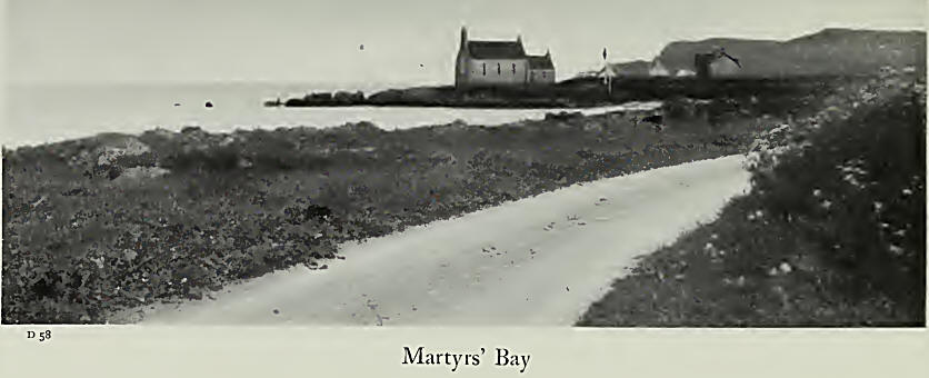
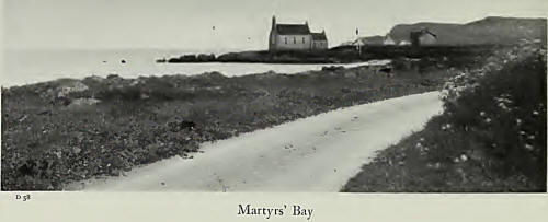
Martyrs’ Bay lies not far south of the village. On its
southern promontory stands the little Free Kirk (now U.F.) which with its
modest dimensions and innocence of art strikes perhaps a more harmonious
note than the mediaeval Cathedral in the island of Columba. Tradition
associates this spot with the first recorded slaughter of the monks by the
Danes in 806.
It was to this little port that the galleys and barges of old
brought the distinguished dead of many centuries. Opposite the bay is a low,
green mound called Eala, and here the bodies were laid for a space, while
the mourners gathered round “to pour their wailing over the dead ”.
Slightly south of the bay, a field contains the site of an
ancient burying-ground, of which there were several in Iona.
The Street of the Dead. This is the traditional name of the
road that led from Martyrs’ Bay to Reilig Orain, and marked the route of the
funeral trains of old. The road slanted inland in the direction of the
Nunnery, turned to the right through a stone archway (remembered by some of
the last generation of islanders) between the Nunnery and Cnoc Mor, and,
contrary to the present road, passed Maclean’s Cross on the west side. |