The climate of a
district, which may generally be defined as its average weather, depends
upon the amount of heat and moisture, and these in turn depend upon
latitude, altitude, slope, and, in some degree also, on the state of
cultivation. Britain is in the same latitude as ice-bound Labrador, yet
it possesses a temperate climate, due to the fact that the prevailing
winds being from the west or south-west bring with them a certain amount
of moisture and heat acquired in their passage over the Atlantic, which
is three degrees warmer than the air. This explains why the west coast
of Britain is warmer than the east. For the same reason the east is
drier than the west, for the winds in passing over the mountains part
with their moisture before reaching the east coast. .
The physical configuration of Kincardineshire has much to do with both
its temperature and its rainfall. Situated on the extreme south-eastern
slope of the central highlands, it has behind it the immense extent of
the Aberdeenshire, Perthshire, and Argyleshire mountains, shutting it
off from the Atlantic seaboard. Thus the winds of winter from that
quarter get gradually cooled and, reaching the east, speak not of the
warm Atlantic, but of the snow-clad Grampians. One degree of diminution
of temperature for every 300 ft. of elevation brings the west-coast
temperature of 390 for January down to 290, or 30 below freezing point,
at the ridge of the Grampians, an elevation of almost 3000 ft. above
sea-level. There is, even at sea-level, a difference of from 2° to 30
between the mean annual temperature of the west and the east coast.
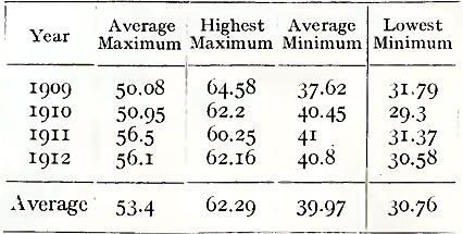
The mean annual
temperature of the county is 46° ; of summer 58°; and of winter 370. For
comparison we give the temperature at Cowie Mains, Stonehaven, for four
years:
During the winter the
greatest amount of snow is from north-east and east, the most intense
colds are from north and north-west, and the greatest amount of heat
from south and south-west. The fact that Kincardineshire lies open and
shelterless to the North Sea accounts for the biting winds of early
spring, often accompanied by heavy rains. From the same source very
often in April and May chill haars and hazes set in towards evening.
Hoar frosts are prevalent in the neighbourhood of the mosses and
low-lying marshy spots in the county, although by improved drainage and
cultivation the area subject to this has been materially reduced.
Kincardineshire, being much diversified into hill and dale, with a great
variety of altitude and exposure, has a difference of climate in its
various divisions. Deeside, for example, although in the extreme north
of the county, is the warmest district. This arises from several causes.
First, it has a genial southern exposure. Secondly, it is sheltered by a
number of small hills rising gradually from the Dee. Its dry gravelly
soil readily absorbs any excess of moisture, while its pine woods and
thriving plantations moderate the climate as well as adorn the
landscape.
The climate of the Howe is both warm and equable. On the north the Howe
is protected by the Grampians; on the south and the east it is
sheltered by the Garvock Heights from the full sweep of the North Sea
winds in winter and early spring ; at the southern extremity it is open
to the genial westerly breezes of summer.
In the heat of summer the coast is delightfully cool and refreshing; but
the glens and hollows of the Grampians are often very close and warm,
though extremely cold in winter.
On the whole, the climate of Kincardineshire is bracing and healthy,
with remarkably pure and exhilarating air.
The rainfall of the
county, compared with the excessive fall on the w^est coast of Scotland,
is relatively small. The mean depth in inches is 32.25, as against 40,
45, or even 70 inches on the Atlantic coast, and 44 for the whole
country. At Stonehaven the average annual rainfall for the past
twenty-one years has only been 27.13 inches; which partly explains its
popularity as a holiday resort. During the same period the average for
any month of the year has not been more than 3 inches of rainfall, the
average for the first four months of the year being 1.86 inches. An
increase in elevation usually brings with it an increased rainfall. Thus
the Burn, 14 miles inland, with an elevation of about 300 ft., has a
fall of over 35 inches ; Banchory (almost 200 ft.) 30 inches;
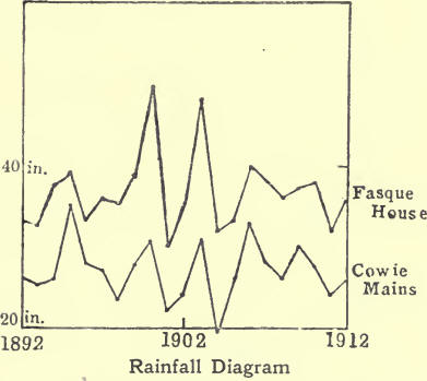
Fettercairn (230 ft.) 32 inches. The diagram, above, of the rainfall for
twenty-one years, from 1892 to 1912 inclusive, at Cowie Mains,
Stonehaven, and at Fasque House (330 ft. above sea-level), illustrates
this, besides shoving the annual variations in rainfall at each of these
places; and may be regarded as fairly typical of the maritime and the
inland districts of the county.
|

