|
Banffshire, with an area of
403,053 acres, about 630 square miles, stands fourteenth among Scottish
counties. From north-east to south-west, it is 67 miles long; its greatest
width, which is along the coast, is 32 miles, but at Keith, near the centre
of the county, it narrows to about
nine miles, again expanding
southward, so that in shape it may be said to resemble an hour-glass.
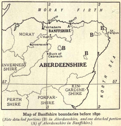
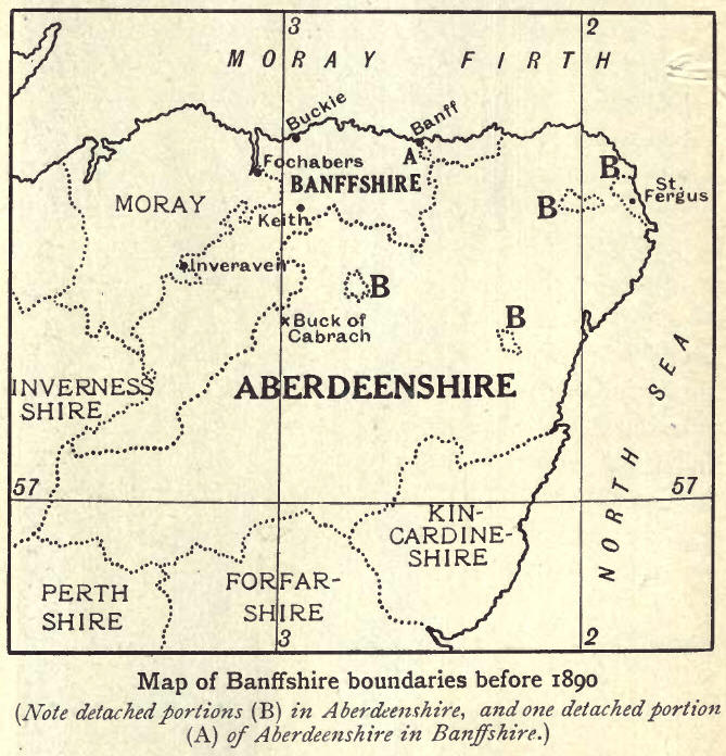
Previous to the Local
Government Act of 1889, of thirty civil parishes in Banffshire, eighteen
were wholly within the county, portions of six were in Aberdeenshire, and
five in Moray, while one was wholly detached, the parish of St Fergus in
Eastern Buchan. It was originally the property of a family who, as
hereditary Sheriffs of Banff were naturally desirous to have their domain
within their own. jurisdiction and were able to secure its annexation to
Banffshire; but this feudal peculiarity ceased in 1890. At the same time the
other parishes belonging to different shires were transferred to one. Thus
the parishes of St Fergus, Old Deer, New Machar, Gartly and Glass became
wholly Aberdeenshire, while Bellie and Rothes were placed altogether in
Moray. The whole parishes of Cabrach, Boharm, Inveraven and Keith were
transferred to Banff. The Banffshire portions of Cairnie and King Edward
were attached to other parishes of Banffshire.
The Moray Firth forms the
boundary from the Tynet Burn to the Tore Burn, where the county marches with
Aberdeenshire. The boundary then runs south and west in a sinuous line to
the Deveron near Eden House. Onwards to where the Isla joins the Deveron,
near Rothiemay, the river sometimes is and sometimes is not the dividing
line. As far as Grange station the Isla is the boundary, which then mounts
the watershed between Deveron and Spey, and, sweeping past Glass, crosses
the Deveron and continues by the Buck of the Cabrach round by Ben Aven and
Ben Macdhui to the skirts of Braeriach, where it bids goodbye to
Aberdeenshire. Meeting Inverness-shire and turning to the north-east, the
boundary passes Cairngorm and twists north-east, north and north-west to the
Cromdale Hills, where it touches Moray. It holds north to the Spey near
Ballindalloch Station. Except for a short distance round Ben Aigan, the
river is the march till near Fochabers. Then the boundary goes in an
irregular line by Thief's Hill, and zigzags to the Tynet Burn, along which
it runs to the sea. |