PRESBYTERY OF KINCARDINE O'NEIL, SYNOD OF ABERDEEN.
THE REV. ROBERT MILNE MILLER, MINISTER.
I.— Topography and Natural History.
Name.—Aboyne is compounded of the Gaelic words,
A, a ford, and boinne or
buinne, a current of rippling water; a name very descriptive of a
ford in the Dee, a little south of the church. Glentanner is compounded
of the Gaelic words Glean-tan-ar, signifying the glen of
scanty arable land. The two parishes being now united are generally
known by the name of Aboyne.
Boundaries and Extent—The united parish, on the
west and left bank of the Dee, is bounded by Tullich, and on the right
bank by Glenmuick; on the south, by Lochlee and Birse; on the east, by
Kincardine O'Neil; and on the north, by Lumphan-an, Coull, and
Logie-Coldstone; the boundary line being generally formed by
mountain-crests, the river Dee, or some of its tributary streams. A
detached part, containing a population of about 60, is situated on the
left bank of the Feugh, not far from the north base of Clach-na-bein,
and about nine miles south-east from the church. Between this detached
part and the church, almost the whole of Birse intervenes. The form of
the parish is very irregular. Its length from east to west may be 13
miles, and its breadth from north to south, 12 miles. These, however,
are taken from extreme points; and its whole area may be calculated at
37,000 imperial acres. Glentanner is on the right bank of the Dee,
bounded on the north by that river, and on the west,
south, and east by ranges of the Grampians. The arable part is formed
into two divisions by the hill of Bellrory, sloping eastward near to the
Inver of the Tanner, which flows through the south-east division, or
what is generally known by the name of Tannerside. The other division
slopes from Bellrory in a north-east direction towards the Fan. [Fan—"a
descent." The river here, in a confined channel, passes with great
impetuosity over a ledge of rocks.] About a mile east of
the Fan, on the right bank of the Dee, are the ruins of the old church
of Glentanner, with an enclosed burying-ground still around it; which,
having been thatched with heather, was known by the name of the Black
Chapel of the Moor. Previously to Glentanner's being united to Aboyne,
it formed a separate chaplainry. Aboyne, which is mostly on the left
bank of the Dee, was then united to Tullich, with an intermediate chapel
at Braeroddach equally distant from the churches of Aboyne and Tullich.
At what period Aboyne and Glentanner were formed into one parish, is
unknown to the writer; but, previously to 1763, there was a church at
each, in which the incumbent performed Divine service in the rotation of
two Sabbaths at Aboyne, and the third at Glentanner. That part of Aboyne
on the north or left bank of the Dee formed the barony which, in the
words of Gordon of Straloch, "titulos Baronis Paralamentarii dat
Marchionis Huntlaei filiorum uni." Its burgh, called Charlestown,
(formerly Bunty,) stands near Aboyne Castle. The tolbooth was demolished
about fifty years ago ; and all traces of the pot and gallows also are
nearly effaced.
Climate.—-The banks of the Dee and braes of Marr
have long been celebrated as favourable to health, and although so far
inland as Aboyne, (the parish being between the twenty-fourth and
thirty-seventh mile-stones from Aberdeen,) heavy falls of snow in
winter, accompanied with intense frost, do often occur, yet the general
salubrity of the air is not destroyed by those sudden alternations of
heat and cold which are frequent in localities nearer the coast, and
more under the influence of the sea breeze. The dry and sandy soil of
Strathdee, the shelter of its close and numerous woods, and the
reflection of the sun's rays from the mountains which tower on either
side, all combine to raise the temperature, and render the climate
remarkably genial. Hence many strangers resort in summer to this
district, for the recovery or invigoration of their health, by breathing
the salubrious air, and drinking goat whey, or chalybeate water. The
most of these visitors are contented for exercise, with a walk along the
shaded banks of the river, while a few, more to brace their
constitutions, may be seen threading their way through heath and alpine
forests, or scaling crags and lofty hills, from whose summits may be
seen the dense smoke of Aberdeen, Montrose, &c. curling in dark clouds
on the distant horizon.
Hydrography.—The river Dee, which runs either
along or through the parish for fifteen miles, rises in the highest
ground of Britain, the mountains which separate Braemar from Badenoch;
and, after a north-easterly course of nearly one hundred miles, it falls
into the German Ocean at Aberdeen.
The Tanner, which rises from Mountkeen, the Allachy
and the Gairney, both issuing from the Firmonth and other hills of the
Grampian range, all flow for miles through the natural forest of
Glentanner, then unite in one body, and, after intersecting the arable
part of the strath in a north-easterly direction, fall into the Dee on
its right bank, about half a mile west of the church.
The Feugh, which rises in the forest of Birse, waters
the detached part of Aboyne, and empties itself into the Dee opposite to
Banchory-Ternan.
The burn of Dinnet, which is the western boundary
line on the left bank of the Dee, is formed by the united streamlets
disembogued from lochs Kinord and Dawin, in the adjoining parishes of
Tullich and Logie-Coldstone.
The burn which flows past, and forms a picturesque
moat round Aboyne Castle (also on the left bank of the Dee) bears
different names in its course through Cromar; and, after reaching the
parish of Aboyne, is generally called the burn of Aboyne; but here its
ancient name was Allach. This name has been dropped, except in one
place, where a bridge over it near the castle is called the Allach
Bridge.
The burn of Dess, which, on the same bank of the Dee,
divides the parish from the old barony of O'Neil on the east, flows
about a mile from the loch of Auchlossen into the river, and is
remarkable for a high and romantic cascade, called the Sloc of Dess.
Several other streamlets in the parish, such as the
Aultroy, Aultdinny, Contullich Burn, the Rossachy, &c. might be
mentioned.
At some remote period, before the waters forced
natural barriers which had intersected the present courses of the
running streams, extensive lakes must have existed. One striking place,
where such a barrier to the Tanner appears to have stood, is near the
influx of Aultroy, and another at Bridge of Ash. Before these barriers
yielded to the Tanner, the upper glen must have formed the bed of a
lake. The several heights at which the water, after different
disruptions, had stood, may be traced,—the same, on a smaller scale, as
the famed parallel roads in Glenroy. The most considerable lakes still
remaining, are those of Braerod-dach and Auchlossen. The extent of the
former may be about 60 acres, and of the latter 300. The greater part of
the latter, however, is in the parish of Lumphanan, and, previously to
its outlet at Drumduan, in the parish of Aboyne, having about 150 years
ago been deepened with the view of draining the whole lake, must have
been of more than double its present extent, and its waters had then
reached the strongly fortified mound of Peel Bog, under whose fosse
Macbeth received his death wound. [Macbeth
maintained himself for three years in this district after the battle of
Dunsinane, before he fell at the Peel Bog of
Lumphanan.] Within the policies of Aboyne Castle, there is also a
lake covering 32 acres, artificially formed, and interspersed with
wooded islets. From the higher grounds overlooking this lake, the view
is extensive and interesting.
Numerous channels, in which it is evident the Dee has
formerly run, many of them at a very considerable altitude above its
present bed, are distinctly visible; at which period, as already
noticed, lakes must have stood on some of the land basins, now filled
with water borne debris, gradually excavated from the higher grounds by
the descending river. The water power within the parish, of which the
only use now made is to drive a few mills for country purposes, would be
more than sufficient to supersede the steam required for moving the
machinery in all the public works in and about Aberdeen; and to render
the power more available, a railroad along the banks of the Dee could be
formed more easily than in most localities, the gradient being only 420
feet on 31 miles, and it is thought no tunnelling would be required.
Geology and Mineralogy.—The geognostic appearance
of the parish indicates little beyond the primitive formation of
granite, and of that little the student, without the sinking of shafts,
may, by examining the face of the mountains, easily inform himself.
The granite is various, and, as its component parts
of quartz, mica, felspar, and hornblende predominate, differs in
hardness of grain, and is diversified in colour from the white to the
black tinge and the red. Some of the red has been beautifully polished.
It much resembles that of Peterhead, but is more variegated in size of
grain and shades of colour. Along the valley of the Dee, to the east of
Lochnagar, rolled masses of the primitive rock of that mountain are to
be found ; and it is also remarkable, that, at a lower level, fragments
of the black ferruginous rock, of which the ledge at the Linn of Muick
is composed, can be traced along the same valley, but in a line
frequently diverging from the present channel of the Dee, and only found
to the east of the confluence of the Muick with the Dee. To account for
this, the appearance at the Linn indicates that the river, in some of
its fitful risings, had swept before it a huge mass of the opposing
rock,—hence the disruption in its fall, and, tossed by the maddened
stream against harder formations, it had been split into fragments, and
deposited along the then channel of the Dee. In the hill of Glentanner,
topazes fit for the lapidary are often found. Crystallized quartz, both
pale and rose, are frequently picked up, and occasionally, in the heart
of granite blocks, beautifully studded nests of them are disclosed.
Gneiss is common in the parish, and, in a few localities, limestone (not
very pure) on both sides of the river; also ironstone, and, in stray
river boulders, faint appearances of manganese conglomerating with
quartz occur, but no traces of any organic remains.
On the left bank of Aultdinny is fuller's earth,
which has been successfully tried as a substitute for soap. In the hills
are extensive peat-mosses, in some of which, after the removal of the
peat formation, at the depth of five or six feet, the original surface
appears covered with charred oak, hazel, and birch. The soil along the
banks of the rivers is thin ; from the rapidity of the streams, the only
alluvial deposit formed, is of sand and gravel; but ascending from the
rivers the fields improve, and some of them are of either a black or
clayey till.
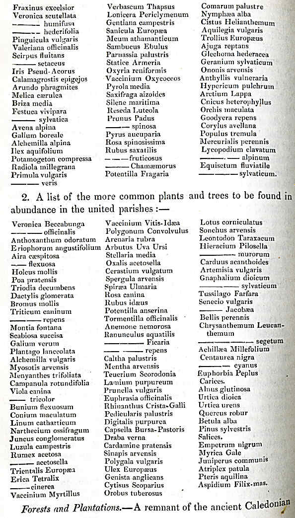
Botany.—For the following list of plants and
trees indigenous in the parish, the writer is indebted to Mr A.
Thomson, the parochial schoolmaster,—a gentleman who has devoted much
attention to botany.
A list of a few of the rarer plants and trees to be
found indigenous in the united parishes:—
forest, extending to about 4500 acres, still exists
in Glentanner. It is now very open, but if preserved, the most of the
hills and valleys would soon be again covered with natural alpine fir;
and it is observable that this tendency to
extend itself is generally towards the east; the prevailing wind, at the
time the seed is ripe and falling, being from the west. The plantations
about Aboyne Castle contain 2144 acres, consisting chiefly of Scotch
fir, but with a considerable proportion of larch, oak, ash, beech, elm,
and other species of hard-wood and ornamental trees.
The plantations on the Balnacraig property amount to
about 1400 acres. They are almost exclusively of Scotch fir, and very
advantageously situated on the banks of the Dee, for transmission of the
timber to Aberdeen. The whole of the woods in the parish are
flourishing, and give every indication that the soil and climate are
congenial for their support.
II.
—Civil History.
Eminent Men.—The chief characters of eminence
connected with this parish have been the Earls of Aboyne and members of
that Noble family ; but an account of the more distinguished of these is
to be found in the general history of Scotland. It may not, however, be
out of place here to state, that George, fifth Earl of Aboyne, succeeded
to the Marquisate of Huntly on the death of George, fifth and last Duke
of Gordon, eighth Marquis of Huntly, on 28th May 1836. The pedigree, as
on that occasion proved before the House of Lords, shows that the late
Earl and his son, the present Marquis, have been seized in the estates
of Aboyne since 1732, the unusual period of 110 years; and that since
the lamented death of the last Duke, S. P., the Marquis has become chief
of the Gordons, a clan ever bydand ; and that the loyalty which
held the Crown on James III.'s head, "animo non astutia," has never been
wanting in their chief.
Adam Gordon of Aboyne, second son of George, second
Earl of Huntly by his Countess the Lady Jean Stuart, daughter of James
I., became Earl of Sutherland by marrying Elizabeth, sole heiress of
John, thirteenth Earl of Sutherland. This Countess Elizabeth died in
1535, and her husband, Earl Adam, in 1537, both at Ferrack, (now Ferrar)
in Aboyne; and were buried there. (Sir R. Gordon's History of the
Sutherland family, page 103.)
William Bisset of Aboyne, and chief of the tribe, was
accused of burning the House at Haddington, in which, 1242, Patrick,
Earl of Athol, and two of his servants were consumed. Bisset proved, by
the evidence of the Queen, that he was that night at Forfar. The
Chronici Scotiae even state that he was in "Castro suo de Obeyne." He
offered to assert his innocence in single combat; this was declined; and
some of the Aboyne vassals having been that night seen at Haddington,
and enmity subsisting between Athol and the Bissets, William was afraid
of the power of his adversaries, the Cummines, and did not stand his
trial, but passed over into Ireland, where, as stated by Buchanan, lib.
vii. cap. 57 he left a noble family. This family is now extinct. In the
parish of Aboyne, there is not now a single person of the name of Bisset;
and within less than a century (1335) the Earl of Athol and other two
Cummine chiefs fell in Edward's army at Culblean six miles from Aboyne
Castle.
The late Thomas Innes, A. M., Principal of the Scots
College at Paris, was born at Drumgask, in the parish of Aboyne. He is
well known as one of the most learned of Scottish antiquaries. He
published a Critical Essay on the Ancient Inhabitants of Scotland, two
vols. 8vo, London, 1729. His elder brother Lewis was his predecessor in
said college ; and more lately, their nephew, the Reverend Henry Innes,
was procurator of the same college. This individual died at the advanced
age of eighty-eight, and was buried at Aboyne in 1832; and it is
remarkable of him, that he was probably the last individual in this
country who corresponded with the unfortunate Charles Stewart. Two of
that Prince's letters addressed to him, the one dated "Florence, 18th
July 1777," and the other, " Florence, 13th February 1778," and signed
Charles R., are now before the writer.
The late James Cromar, A. M., a very successful
teacher of youth, and who died rector of the grammar-school of Aberdeen
in 1826, was a native of this parish.
Alexander Ross, author of the Fortunate Shepherdess,
and of many popular songs, was translated from the office of parochial
schoolmaster at Aboyne to that of Lochlee.
As connected with the parish, it may be also
mentioned, that the adventurous Peter Williamson, who, about 1740, was
kidnapped at Aberdeen and carried to Virginia, and there sold for a
slave, was, as stated in his autobiography, born in the parish of Aboyne,
if not of rich, yet of reputable parents.
Land-owners.—These are, 1. the Marquis of Huntly,
whose valued rent in the parish is L.1631, I7s.
8d.; 2. John Farquharson of Finzean, with a valued rent of L.200,
4s. 6d.; 3. Miss Farquharson, Mrs Lynch, and their sisters, Misses
Catherine and Louisa Farquharson, (L. 173, 6s. 8d.) who succeeded as
heirs-portioners to their brother, the late Lewis Farquharson Innes of
Balnacraig and Ballogie. Their father was male representative of the
ancient house of Inverey, and on succeeding to the lands of Ballogie and
Balnacraig, &c. in this and the neighbouring parishes of Birse and
Kincardine, assumed the name of Innes, that of his relatives, the former
proprietors. One of his authors, Findly Farquharson of Inverey, was
killed carrying the Royal banner at the battle of pinkie, 1547. 4. The
Earl of Aberdeen, who is proprietor of a small farm in the parish, but
to which no valued rent is attached. Historical Events.—There are
no papers or writings of which the writer is aware, that can throw much
light on events of former times, and tradition furnishes but few
particulars respecting the early history of Aboyne; hence at what time
even the castle was first built, the writer is unable to obtain distinct
evidence.—Possibly this might be supplied by the Huntly charters, and
the date of the royal permission for its erection ascertained. It may,
however, be inferred, from the circumstance of the castle being placed
in a swamp,-and having (till in recent times the water was lowered) been
accessible only by boat or drawbridge, that it was erected about the
tenth or eleventh century,—the moat fortification being then followed
for castles, as previously and subsequently duns, rocks or some eminence
secure from sudden attack were selected for strongholds and baronial
castles. In 1242, it was possessed by William Bisset, who being then, as
already noticed, accused as accessory to the death of the Earl of Athol,
was summoned to stand his trial at Edinburgh. He went there, and offered
to peril his life with any of his accusers, but his challenge was not
accepted, and he being afraid that his judges might be concussed by his
inveterate and powerful enemies, the Cummines, went with a number of his
relations into voluntary exile in Ireland. From the chartulary of
Aberdeen, it appears that the Bissets gave the lands of Aboyne to the
Knights Templar, and it is a remarkable fact, that some fields near the
castle still bear the name of "Tiran Teampull," i.e. the Templars'
ground, which circumstance is evidence that Gaelic was then the
vernacular language about Aboyne, but which has long since retired
farther west. Regarding the possession of the castle by the Earl of
Marr, there is also an order from Baliol, recorded in the "Rotuli
Scotiae." From the Knights Templar the lands of Aboyne passed to the
Frasers of Cowie, and from the Frasers to Lord Keith, progenitor of the
Earl Marischal. Lord Keith's daughter, Elizabeth, was married to Sir
John Gordon of Huntly, and with her the lands and castle of Aboyne
passed to the Gordons, with whom they have since remained. Sir John was
killed at the battle of Otterburn, 1388 and his only daughter and
heiress was married in 1408, to Sir William Seaton of Seaton Mallonally,
descended from a sister of Robert I.
Their son Alexander was, in 1449, created Earl of
Huntly, and resumed the surname of Gordon. This Earl Alexander was
succeeded by his son George, in favour of whose second son Adam (who
afterwards became Earl of Sutherland,) it is stated, in Gordon's history
of the clan, that James II. granted a
novodamus of the lands of Aboyne. They seem, however, to have reverted
to the Earl of Huntly, and to have been bestowed successively on the
second sons of that noble house, first, on John, who was cruelly burned
to death at Frendraught, on 30th April 1630, and secondly, on James
Viscount Aboyne, on whose death they passed to his next brother Charles,
who was created Earl of Aboyne, and of whom is lineally descended the
present Marquis of Huntly.
In 1671 the castle was repaired or rather part of it
rebuilt, by Charles first Earl of Aboyne, and in 1801, his great
grandson, the present Marquis of Huntly, added the east wing or half to
it, corresponding in appearance and architecture to the west, on which
occasion, the old foundations, which had been laid on brandered oak
above peat moss, were raised of what had once been the baronial hall.
The old mansion-house of Balnacraig, [While
a party of military were preparing to burn the house of Balnacraig in
1746, a soldier thrust his head into a jar of honey, from which he could
only, amid the jeering of his comrades, be extricated by breaking part
from the mouth of the jar. —during this scene a counter order to save
the house arrived. The honey jar, with its broken lip, has been
preserved by the representatives of the family.] in which the
former proprietor resided, is in the parish, and on the Balnacraig
property is also the House of Carlogie, now occupied by Admiral Sir
Arthur Farquhar. At Tillphoudie, once the seat of a branch of the
Gordons, but now forming part of the Aboyne property, are to be seen the
ruins of the proprietor's house.
Antiquities.— On Knockbeg, or little hill of
Tillfoudie, are the remains of a circular building, [The
writer has seen the remains of similar stone buildings, extending in
a line across Sutherland. The most entire one he has met with is
on the Blackwater, Strath Brora, and called "Castle Coull."
There are also a few of the round "turf forts or
pits" close to the turnpike road two miles east from Fort George.]
(diameter 83 feet,) composed of stones regularly laid, and the
foundation partly imbedded in rock, but without mortar or cement; and at
the base of the hill, in a corn-field, about half a mile to the
north-east, may be traced the site of another erection, said to have
been similar; and connecting them are to be seen the remains of two
parallel dikes, forming a fenced avenue or roadway. This avenue, thus
secured on each side and in no place under the breadth of fifteen feet,
though in many places more than double that extent, leads to the east
over the adjoining moor of Drumduan, and can be traced for miles, in the
direction of the hill of Fare, where, the writer has been told, it is
connected with similarly raised structures, known by the name of Pict's
houses or forts. The line extends also westward to the hill of Knockice,
and Kinord, and is there too connected with a number of these Picts'
houses, though none of them, like the one on Knockbeg, has been erected
entirely of stone. From Knockice, the enclosed line branches off towards
a ford in the Dee, and appears on the opposite side in Glentanner, with
more of these ancient ruins planted, at intermediate spaces, along it.
The same is observable at Tillphoudie hill (distant
from Knockice five miles,) leading also towards a ford in the
Dee, and not far from either bank are two of these raised forts, placed
like lunettes to protect the passage. Both the diverging lines seem to
point to a pass through the Grampians, directly leading to Catterthun,
the great Caledonian fort, about twenty miles distant, in the braes of
Angus, and thought by some to have been a stronghold of Galgacus. The
main line may be traced nearly parallel with the north bank of the Dee,
for about fifty miles from hill of Fare by Knockice to Braemar, said to
be the Tamea of the Romans, and these parallel dikes (a
line of them branching also northward from Knockice) have been
represented by some antiquaries as the remains of itinera of that
people. The dikes, however, appear always in connection with these round
forts or pits, which was the form adopted by the Picts and the ancient
Scots for their places of strength. Those of the Romans were
rectangular, and the stone one on Little hill (to and from which the
iter evidently led,) had been erected without lime or mortar, which
would not likely have been the case had it been of Roman origin. At
Knockice, along the south face and base of Mulloch hill, [Mulloch,
Gaelic, "the top or highest part of the mountain." On this Mulloch or
summit of the hill, there is a cairn 60 yards in circumference, and the
average depth of the stones 2 yards. There is a confused tradition that
this cairn marks the spot on which some Danish King or
general fell. It is not, however, raised conicadly, but flattened like
cairns on other hills (and several of them can be seen from it,) on
which beacon fires are said to have been lighted.] are the
ruins of three rectangular stone enclosures, all close to and connected
with each other. The west-most one, 140 yards by 88, the next larger,
and the eastmost about double the size of the other two. All the three
have been apparently open on the south side, except in so far as
naturally secured by a small rill of water and marshy ground. There are
two smaller enclosures, of from 12 to 18 yards diameter, a little out
from the north-west corner of the smallest of the three, on steep rising
ground, and overlooking the whole. The road or diked avenue from Kinord
leads to the westmost of the three, and is lost in it. It again appears
skirting the other two, except in one place where it is blocked up by
the wall of the inclosure, to form which the stones of the two dikes
appear in that place to have been removed. Hence if these be the remains
of a Roman encampment for the troops of Domitian or Severus, as some
have inferred, the encampment and the iter must have been formed at
different times, and if by the Romans, it is not likely they would, in
an enemy's country, have blocked up their iter without the formation of
a new line. It may be noticed, that the enclosures had been mere fences
of loose stone and turf, without any outside ditch, and present nothing
of the formidable appearance of a Roman rampart. Three sides of the hill
slope as regularly as if they had by art been formed into a glacis; and
contain several deep trenches, of no great length, like so many redoubts
to check an advancing army; and the whole ground is covered with cairns,
many of them within the inclosures; and the tradition of the country is
strong, that more than one severe battle had been fought
on this ground, but when, or by whom, an opinion cannot well be
formed. One tradition is, and some authors have stated it as a fact, on
what evidence is unknown to the writer, that the Romans did pass to
Moray by Brae-mar, and were signally routed at Knockice. Severus indeed,
with his son Caracalla, did attempt, in the year 208, the entire
conquest of Scotland; but, after losing 50,000 men in one campaign, was
glad to retire south of the Tyne, and the Romans never again evinced any
desire to face the six Scottish knights,
Sir Moss, Sir Moor, and Sir Mountain,
Sir Rock, Sir River, and Sir Duntan.
Among other antiquities in the parish there is, close
to the turnpike road near the bridge of Dess, a large round stone with a
hole in the centre, somewhat like that of a millstone, and supposed to
have been used for the erection of a gibbet-tree. It was, about twenty
years ago, with the view of examining it, placed on its hem, and, on
raising it from the flat bed on which it rested, there was some
difficulty experienced, in consequence of large stones which had been
laid around to firm it. That it was a gibbet-stone, may be the more
readily inferred from its being placed at the foot of a natural tumulus,
which bears the significant name of Tiremod," i. e. "the
court-ground."
Six years ago, a canoe, neatly formed out of a single
block of oak, was dug out of the peat-moss at Drumduan, on the south
side of Auchlossan Loch. It was quite entire; but being in an unsound
state, and left on the bank to dry, it was unfortunately broken by the
rude handling of some herd boys.
On a knoll near Aboyne Castle stands a sculptured
stone, six and a-half feet high. This stone formerly stood on an
eminence nearly fronting the land end
of the drawbridge which had communicated with Ceanmore's
fortified island in Loch Kinord, but, in commemoration of which of the
many eventful occurrences connected with that locality, no evidence
exists beyond its carved hieroglyphics; and as these contain what
appears intended to represent a cross, curiously and very laboriously
cut, it may be inferred to have been erected within the Christian era.
It was removed by the Earl of Aboyne from its original site to that
which it now occupies near a small Druidical circle; hence its history
may, at some future period, puzzle the antiquary.
About a mile and a-half north-west from the church,
there is a stone with a cross cut on it, and standing near a well. This
stone, when removed at some olden time, is said to have been
miraculously brought back by Muchrieha, the guardian of the well. Near
the cross formerly stood a stone of considerable size, with a hollow
rudely cut in it, and called Muchrieha's chair. This chair some masons,
about thirty years ago, unawed by Muchrieha, split into pieces to assist
in the building of the neighbouring farm-house.
On the hill of Little Tullich, overlooking the site
of the old Castle of Cean-na-coil, are the remains of what is
called "My Lord's House," consisting of five courses of a square stone
building, the wall at the base course 12 feet thick, and diminishing
about a foot each course, so that the five courses present, on the
outside, the appearance of a stair of as many steps on each side. The
entry is from the west, and the apartment within is
7½ feet each side. The base course also projects inwardly
from 12 to 15 inches, forming a seat or bench all around; and in laying
the courses no cement had been used. It may have been originally arched
or roofed in, but it is now open, and the height of the apartment within
from 5 to 6 feet. The use of this building is reported to have been for
obtaining a view during a deer-hunt; and this part of the ancient forest
of Marr being the nearest to the old Castle of Kincardine (about fifteen
miles distant,) which was frequently honoured with a royal visit, it is
thought it was in this locality his Majesty, Alexander III., was saved
from an infuriated stag by Colin Fitzgerald, of whom were descended the
Earls of Seaforth. The charter in favour of Fitzgerald for the lands of
Kintail is dated "Apud Kincardine ix. die Jan. anno regni nostri xviii."
or 1267; and the interesting occurrence which becomes associated with
the date and locality of this charter, was, as recorded by Sir George
Mackenzie of Tarbet, "about that time when Alexander was on a hunting
excursion in the forest of Marr, an exasperated stag, hotly pursued by
the hounds, made a dead push at the place occupied by the King, when
Colin bravely interposed his own person, and adroitly shot, with an
arrow, the infuriated assailant."
Half-way between the castle and the old church is an
old tree called the Skeulan tree, and a well called the Skeulan Well.
They are still held in great veneration, and the name appears to be a
corruption of St Eunan, to whom the parish and church of Aboyne were
anciently dedicated. Within a short distance of the Skeulan tree, there
is another well called the Lady's Well.
At Newton of Tilliecairn, in 1828, several urns,
containing calcined bones, were dug up while trenching some ground, one
of them perfectly entire: and the gentleman into whose possession it has
fallen has either lately presented it, or intends to present it, to the
Museum of Marischal College. About fifty yards distant from the tumulus
in which the urns were found, the soil has a blackish appearance, with
small pieces of charcoal imbedded in it, the whole appearing to have
been under the action of strong fire; and here, it is presumed, the
bodies had been burned, preparatory to the calcined remains being placed
in the urns. And it may be remarked, too, that the site is near some
Picts' houses, or as they are here called, Mullochies, on the
communication bran of the parallel dikes which diverge from Knockice on
the opposite side of the Dee.
Nearly a mile to the east of Newton, on the top of a
ridge on which are several small cairns, is one of great extent called
Cairn-more, which, in 1818, was partly opened for the purpose of
obtaining stones for the erection of a house, when a number of bones
were found, and a small gold chain of four links, attached to a pin of
such size as might have been used in a brooch for fastening the Celtic
plaid. The bottom of the cairn was neatly paved, and about one-tenth
part of it only has been explored.
On the summit of the hill of Mortlich, in this
parish, has been a pretty large enclosure, apparently an extensive
encampment. Now this is the only Mortlich or Murtlach in Marr; and
Buchanan writes (Lib. vi. cap. xlix.) that Malcolm
II., after a hard-contested action ad Murthilacum in Marria, and
taking advantage of a praesidium or old strength, fortified by a
wall and ditch, gained a signal victory over the Danes. The Peel Bog,
about two miles east from this Mortlich in Marr, most exactly
corresponds with the description given by Buchanan of the praesidium
or old strength. Some, however, think, that the enclosure on the top
of Mortlich may have been used for a more ignoble purpose than that of
an encampment of warriors, and that it was a fence, difficult of access
and easily guarded, for securing the cattle of the country during the
foray of any hostile clan or inroad of pillaging foes.
In 1834, there was dug out of one of the cairns at
Ferrar a sil-ver coin, (hammer struck,) bearing on the obverse, within a
double tressure, or leaves of a rose, (except the bust, which extends to
the legend,) the king's head in profile, with an open crown fleury,
before him the sceptre fleury, with the legend, david dei gra Rex
scotorvm. On the reverse, a cross potent extending to the edge, with a
spur-revel of five points in each quarter. In the inner circle villa
edinbvrgh, (the place of coinage.) In the outer, the legend, +
dns-ptector-ms + libator us, (being the contraction for Dominus
Protector Meus et Liberator Meus.) It hears no date, neither is the
king's name designated by any numbers. It may, therefore, be presumed to
have been of the reign of David I., [Since
the above was sent to press, the writer has seen a copy of "Numismata
Scotiae," from which the coin would appear to have been of the reign of
David II., and that the legend (being common)
was not assumed in reference to the liberation of that Sovereign.
] sixth son of Ceanmore, and who, in 1124, succeeded his brother Edgar;
but those acquainted with the history of Scotch coinage may be able to
determine whether this piece be of the reign of David
II., who, when only eight years of age, succeeded his father,
"the Bruce," in 1329. Of either reign, it would fall within the date
(1335) of the battle of Culblean, fought about two miles to the
westward; and in the direction of Ferrar it is generally admitted the
routed Baliolites fled, closely pursued by "the Gordon" and his gallant
band. Some of the fugitives are reported to have rushed into the mill at
Dinnet, and there (except two saved by the address and bravery of the
miller,) cut down by their fierce pursuers. From this incident the name
of the mill was changed from that of Dinnet, Dion-aite, (sheltering
place,) to Muillean donas (the mill of mischief). The
sucken considered their mill polluted. A new one was erected about
one hundred yards distant; but the old site is still called Muillean
donas. Connected also with the chase from Culblean, a small rill,
nearly a mile north of Aboyne Castle, is called "the bleedy burn," the
tradition being, that, for twenty-four hours, the water was reddened
with the blood of the slain. But "bleedy burn" being expressed in Scotch
and not in Gaelic, it may be inferred, that the occurrence from which
arose the name must have been of more recent date than the battle of
Culblean. If, too, the coin be of the reign of David
II., and if the legend have reference to the liberation of that
monarch from England, (1358,) the piece (and bones found with it in the
cairn) must have been deposited on some memorable occasion subsequent to
the rout, in 1335, from Culblean. Cairns (some of great size) and tumuli
are to be found on every hill and moor in the parish. Some of them may
mark the graves of the Sassenach and the Dane; but many of them may be
claimed by every Celt in the north as a "Cam na Cuimhne," a cairn
of remembrance over a clansman of his own, who fell either in nobly
repelling a foreign foe, or in the direful conflict of chief against
chief. But it is not to be supposed that all these tumuli and cairns
owed their origin to the casualties of war. Around the Druidical places
of worship, there were no cemeteries. Such convenient spots [The
writer knows some remote Highland parishes in which still are many
places of interment which have never been connected with any place of
worship. ] as, amid their pastoral and
migratory life, might at the time occur to the surviving relatives, were
selected, and the grave secured against the ravenous wolf [At
a hunting in forests of Athole and Marr, so late as 1528, a wolf is
mentioned among the game killed by James V.]
by a heap of stones. "Curri mi cloch er do charne," I will add a
stone to your cairn, is still a complimentary
expression among Highlanders.
Parochial Register.—The parochial register only
extends back to 1752. It contains minutes of the kirk-session meetings,
and a record of marriages and births, but not of deaths. The births have
been very irregularly entered, from the neglect of some parents, and the
disinclination of others, to have their children's names recorded.
III.—Population.
In 1755, the population amounted to 1695
1831, - 1163
1841, - 1138
This falling off may be accounted for from the
increased size of the farms and a diminution of the cottar system.
The people are orderly and industrious, shrewd and
intelligent, well informed in the principles of religion, and regular in
their attendance upon its ordinances. A very intelligent and respectable
farmer of the name of Gillanders, who, since the incumbency of the
writer, died in the parish, was the eighteenth oldest son of the family,
who, in succession, had been born on the same farm. The adjoining farm
is now rented by his oldest son; and others in the parish are possessed
of evidence that they, and those they represent, have lived under the
Earls of Aboyne from the time that noble family succeeded to their
honours, and were ever ready to follow their feudal chief to the field.
In more recent times, though the Earl of Aboyne did not formally embark
in the unfortunate risings of 1715 and 1745, yet did his tenants
zealously support "the Prince" with their services. [In
1715 the Earl of Mar, to mature his plans and collect his hounds,
invited his sporting friends to a deer-hunt in Glentanner, and to meet
him at Cean-na-Coil. Thence, with the men of Aboyne, he proceeded
to Braemar Castle, and there unfurled the banner of James
VII. In 1745-6, a battalion, named by Lord
Lewis Gordon "the Aboyne battalion," and commanded by Farquharson of
Monaltree, beat the Macleods at Inverury; and, in the fierce onslaught
at Culloden, cut through "Burrell's Blue." The survivors who returned
from that eventful field are all now beyond the din of war. The writer
remembers seven or eight of them, and has often heard from them an
account of their disastrous adventure.]
IV,—Industry.
Agriculture.— The arable land in the parish is
2178 Scotch acres; and the gross rental is L.3300, (exclusive of
shooting-grounds), which would be at the rate of about L.1, 10s. per
Scotch acre. If, however, the arable were let without the extensive
moorlands and natural pastures attached, the average rent of the arable
would perhaps range from L.1 to L.1, 5s. per Scotch acre. The usual
system of cropping followed in the parish, as generally throughout the
district of Marr, is the seven years' shift; and to observe this
rotation most of the tenants are bound by their leases. A less
exhausting course, however, is beginning to be introduced, viz. the six
years' shift, which only differs from the former by taking one grain
crop instead of two after lea. The only grain crops to which the climate
is found congenial, are oats and big. The surplus grain is carried to
market at Aberdeen, and the carts return loaded with lime, coals, or
bone-dust. There are only three farms in the parish exceeding 100 acres
arable. Most of them are only from 20 to 50 acres, and many of them mere
crofts, extending from 5 to 12 or 15 acres; and the smaller the farm,
generally the higher the rent, arising chiefly from a competition among
steady farm-servants, who have saved from their wages as much as is
sufficient to stock one of these small holdings. The usual duration of
the leases granted is nineteen years. There is improvable ground in the
parish, perhaps equal in extent, and not inferior in natural quality, to
what is already arable, but which, on a nineteen years' lease, would
scarcely repay the expense of bringing it into tillage. In cutting down
the crops, the sickle has of late been superseded by the scythe.
Farm-Buildings.—The farm-houses with lum
and earthen-floor have entirely disappeared, and in they stead plain and
comfortable erections have been built with chimneys, and one end at
least floored with wood; and those erected within the last few years are
slated, and generally of two stories. An improving style of offices has
also begun to be introduced. This better system has chiefly arisen from
the houses becoming more generally the direct property of the
land-owners, in place of being built or paid for by incoming tenants.
Some of the farms, too, have of' late been well enclosed with stone
fences at the expense of the proprietors.
Under this head, it may be also mentioned, that
traces of the plough are visible far up the brows of the hills, and at
greater elevations than it is thought any grain would now ripen. These
alpine rigs are all straight, arising, it is presumed, from the plough [The
plough with a single handle is said to have been then used. The writer
has seen such a plough at work in the higher district of Caithness, and
was struck with its resemblance to the old Roman plough as
described by Virgil, Georgica, lib. i. 162. Ovid, too, alludes to the
single-handed plough, "stiva" (not stivis) "innixus
arator."] having been drawn by the amlin-mor (great yoke,)
to which the cattle were attached abreast. In connection with these
rigs, the more limited operations of the spade or cas-chrom
appear in small cleared patches, from which the grubbed up stones have
been collected into heaps. From the mountain's brow, cultivation would
appear to have gradually descended to the richer and stiffer soils of
the glen, as it became cleared of wood and water, and there the straight
rig of the amlin-mor appears to have been succeeded by the
curvilinear of the ten-oxen-plough.
Live-Stock.—Much attention is bestowed on the
rearing of black-cattle. These are generally of the Aberdeenshire
horned, or of the Buchan polled breeds; but they have of late, on
several farms, been crossed with the short-horned, much to the
improvement of the weight, and a year's earlier maturity of the animals
for the market. A few are fed either for the Aberdeen fleshers, or for
exportation by the steamers for the London market; but a greater number
are disposed of in a lean state to the south of Scotland and English
dealers. From any of these quarters, however, there has been little
demand, and at greatly reduced prices, since the ports were opened for
the admission of foreign cattle. On the hills and moorlands, from 5000
to 6000 sheep, mostly of the Linton breed, are pastured ; and a few pigs
are also to be seen about most of the farm-steadings. The average amount
yearly sold of these different kinds of stock has been calculated at
rather more than half the rent paid to the landowners. The horses are
not heavy, but hardy; and, from the lightness of the soil, a pair of
them is sufficient for drawing a plough, and one of them for carrying in
a cart four quarters of bear to the Aberdeen market.
V.
—Parochial Economy.
Market-Towns.—The united parish is distant
from Aberdeen, the principal market-town, from twenty-four to
thirty-seven miles. Stonehaven is two miles nearer, but with it, though
there be turnpike roads leading to both towns, the intercourse is very
limited. In the village of Charlestown, within the parish, and a quarter
of a mile east of the church, there is a very commodious inn, noted for
the excellent manner in which it is kept: Also a post-office; bake and
brew-house; shop for general goods ; meal, flour, barley, and
malt-mills; shoemakers, carpenters, tailors, and a saddler. Through the
village, a mail-coach to and from Aberdeen passes daily, and several
carriers weekly.
Means of Communication.—The turnpike road from
Aberdeen (which is joined by the one from Stonehaven at Banchory Ter-nan),
terminates at Aboyne; but the communication is continued by excellent
commutation roads, on both sides of the Dee, to Ballater and Braemar.
The Parliamentary road to Alford commences in the parish ; and there are
also, leading from Aboyne good commutation roads in the direction of
Tarland, of the Cairnamonth and to Inchmarnoeh, by either side of
Bellrory. Over the Tanner, there are two stone-bridges, and five over
other tributary streams of the Dee, all arched, besides several other
smaller bridges, either of wood or of stone, but not arched. At the
place where the ferry-boat now passes the Dee, between Kincardine O'Neil
and the lands of Balnacraig, in the parish of Aboyne, a wooden bridge
was erected, by Durward of Coull, in the fourteenth century, but of
which all traces have long since disappeared. Two miles further east, on
the verge of the parish, there is now the elegant stone-bridge of
Potarch, of three arches, and each pier founded on rock. At Aboyne, and
nearly opposite the church, the much admired [Length
of suspension portion, 230 feet; do. of two iron trussed arches, 60 and
50 do. ; and length of two stone arches, 30 and 20 feet; depth of the
foundation of the two principal piers under the level of the river, 11
feet.] chain or suspension-bridge, was erected by the Earl of
Aboyne in 1831, and solely at his Lordship's expense. A previous one, on
the same site, and nearly on the same design, had been constructed in
1828, but which was unfortunately carried away by the great flood of 4th
August 1829. The two bridges cost his Lordship from L.6000 to L. 7000,
and there is no pontage. The stability of this bridge being now tested,
and there being an excellent road, either turnpike or Parliamentary,
from Huntly to Aboyne, a continuation of the line southward, through the
Grampians, is naturally indicated, and a very inviting line as to levels
and facility of formation has been surveyed, from Aboyne, through the
top of forest of Birse, lower part of Glenesk, Clash of Wurren, and
parish of Menmuir, to join the great Strathmore road at a point near the
bridge of Finhaven, distant about twenty-five miles from Aboyne. Were
this projected road formed, (and the estimated expense is less than what
the bridge at Aboyne cost), the saving which would be gained in
travelling from many of the northern counties is not only obvious, but
property along its tract would be greatly enhanced, and a spur given, in
a neglected district, to that spirit of improvement which is generally
carried on along a new line of road, by which easy access is afforded.
Ecclesiastical State.— The church is very
handsome and comfortable, and seated for 628. It was erected this year
at an expense, exclusive of carriages, of about L.900. The manse was
built in 1790, and two new rooms added in 1835. The stipend is L.150, of
which the sum of L.12, 16s. 2½d. is paid by
the Exchequer. The glebe extends to nearly twenty imperial acres, but of
such worthless soil, that it has never repaid the expense of labouring
it. The old glebes of Aboyne and Glentanner, of excellent soil, were, on
the occasion of a central church being built for the united parish in
1763, excambed for double extent of a bleak moor, which had evidently at
one period been the bed of the Dee, and which had scarcely any soil on
it. It is only fit for growing furze and broom, or stunted firs. The
minister has the privilege of a peat-moss, four miles distant, on the
top of a very steep hill.
Education.—The salary of the parochial
schoolmaster is L. 28, which, with allowance from the Dick bequest and
school fees, may raise his income to L. 80 per annum, with house and
garden. The usual branches of education are taught, and the number of
scholars last winter was as high as 140. From the school there is at
present one student at Marischal College and another at King's, both
holding competition bursaries. In the Glentanner division of the parish,
there is a school established by the Society for Propagating Christian
Knowledge, with a salary of L. 16, and the usual accommodations from the
heritors. The average number of scholars, 60 : but their fees do not
amount to much. From remote corners of the parish, several children
attend neighbouring parochial schools, to which they are nearer than to
that of Aboyne ; and in winter, some are instructed in adventure
schools. The minister, parochial and society schoolmasters, are natives
of the parish.
Poor and Parochial Funds___The number of persons
on the poor's roll has nearly doubled within the last few years. They at
present amount to 34. Among them, in proportion to their respective
wants, are divided, by quarterly distributions, about L.35 per annum,
arising from church collections, amounting on an average to L.23;
interest of money, L.3; and the balance from voluntary contributions by
some of the heritors and others. There are no beggars in the parish; and
the paupers on the roll derive much, of their support from the kindness
and beneficence of their more affluent neighbours. Whenever any urgent
case occurs, a contribution in meal and money is immediately made in the
vicinity for its relief.
Fairs.—There are five great markets held on a
green admirably adapted for the purpose, between the village of
Charlestown and the church, viz. at Candlemas, Michaelmas, and
Hallowmas; one also in June, and another in July.
Inns.— There is an excellent, inn, the Huntly
Arms, at Aboyne, and four secondary ones in the parish.
Fuel.—Bog peat and hill turf are used for fuel.
There is also much wood, particularly fir, burned; and many drive coal
from Aberdeen.
Miscellaneous Observations.
Fifty years ago, the fields were regularly checkered
by baulk and rig. Drill husbandry and green crops not to be seen, save
in a few rare patches of grass or turnip in some of the farmers'
kailyards, and perhaps a head-rig or some odd corner in potato for a
bonne louche in harvest. The breed of cattle light, and of an
inferior stamp ; the horses (though mettlesome) mere highland garrons;
the sheep small in carcass, and scanty in wool. The houses of simple
structure: lums for chimneys, and wooden boards for windows. Currocks,
and creels, and litter trees supplied the place of
carts; winnowing weights that of fanners; and hair and moss-fir
tethers, or willow and birch withes, were substitutes for hempen
ropes. The querne was partially used ; and though the laddie
mill had disappeared, it had been only superseded by the cog
and rung. Clumsy and ill-constructed ploughs were drawn by ten or
twelve oxen, with the "curvus arator" slowly turning the huge
furrow, and the gad-man's whistle, in autumn and spring, heard on every
side. The roads were wretched; and the nearest post-office and
bake-house at Aberdeen. Many of the young men appeared in kilt, hose,
and brogues; and all, old and young, at church and market, with breacan
and bonnet. The women, too, were dressed mostly in home-made stuffs, and
gudewives adorned with the barred plaid. The grain raised was little
more than sufficient for the wants of the parish. From seed-time to
harvest many of the men were employed in the manufacture of tubs,
harrows, plough-beams, &c. which they carried to Old Rayne fair, the
Aberdeen timber and Auldton markets. In summer, the women were employed
in spinning the wool of their sheep; and many a web was ready for the
gudewives to start with for Bartle fair of Kincardine. A new order of
things has now gradually sprung up, and the dress and habits of the
people are similar to those in other rural parishes in the county. It
may be also observed, that, fifty years ago, many a legendary tale,
blended with some historical facts respecting the parish, was told ; it
is said that, at some very remote period, an irruption had been made
through the Grampians by an overwhelming host of invaders; that these
were assailed by the natives from the woods, rocks, and hills, and
finally routed at Knockice; [Knockice, i.
e. (Gaelic) Cnochdi, derived from a little hill, and many
cairns in its neighbourhood.] that a line of tumuli and cairns
marks the graves of fallen Danes and northern marauders; that Macbeth
fled from Dunsinane, and maintained himself for three years among the
fastnesses of Marr; and that, in one of his flights for life, and
unattended, through Aboyne—himself exhausted and his mare
jaded—he dismounted to drink from a well situated at the point [The
pass in which the well is situated is known by the name of Tilliebreen,
i. e. Silleadh (the dh quiescent) braon—water
formed by rain falling on opposite hills, and running along their base.
One of the hills here alluded to is Mortlick, (the slack of death,) on
the base of which, and in a mountain pass, Macbeth now stood. Hence the
name of the hill rather than that of the well might have conjured up sad
forebodings to his superstitious mind.] from which he could first
see his castle of Peel Bog, distant about two miles, and, obtaining a
bit of bread from a herd boy, asked him the name of the well, and, being
told that it was Brien (Braon), he ejaculated, "wo is me, the spell is
gone, and my doom is sealed." It is said also, that feuds and conflicts
often raged between the Forbeses and the Gordons, the Gordons and
Farquharsons; and that, after one memorable foray, orphan children were
carried towards the banks of the Spey; and that some of their
descendants are still to be found there bearing the name of "Strathdee."
It is said that the vassals of Aboyne suffered in Marr's year, the
45, and in the wars of Montrose and Dundee; and that Mackay, after "Killiecrankie,"
visited Strathdee with fire and sword; and, in forcing the pass of
Ballater, that, with hand granades, he fired the heath and burned
the forest of Culblean, encamped at Tarland, and, with other parishes,
laid Aboyne under contribution. Hence the couplet,
Wo to the day John Tam was married,
Culblean was burn'd, and Cromar was harried.
Instead of listening much to such traditionary tales
and imperfectly recorded facts, the people now take an interest in
reading standard works on history and general science, and have provided
themselves with a pretty extensive parochial library.
December 1842.

