|
Strathearn; Crieff,
1.—Drummond Castle, 2.—Ferntower; Monument to Sir David Baird, 3.—Roman
Camps at Ardoch, 4—Ardoch to Crieff; Muthil, 5.—Monzie; Seats on direct
Perth Road, 6.—Glen Almond; Pass to the Highlands by Amulree, 7 —Crieff to
Comrie; Ochtertyre; Glen Turret, 8.—Cowrie; Devil's Caldron, 9- Comrie to
Loch Earn; Aberuchill Castle; Dalchonzie; Dunira, 10—St. Ftllan's; Sept
M'Neish, 11—Loch Earn; Falls of Edinample, 12.—Loch Tay; Killin, 13. —Finlarig;
Falls of the Lochy, 14.—Drummond Hill; Falls of Acharn, 15.—Kenmore;
Tavmouth Castle; Pleasure-grounds, 16.—Fortingal; Remarkable Yew Tree;
Cowrie Castle, 17.—Glen Lyon, 18—Cushiville to Kinloch Rannoch; Tummel
Bridge; Dalnacardoch, and Falls of Tummel, 19.—Castle Menzies, 20.—Falls of
Aberfeldy, 21.—Aberfeldy to Dunkeld; Grandtully Castle, 22.
1. THE district of Strathearn,
which intersects the southern portion of Perthshire, in a winding line
nearly due east and west, joining Strath Tay at Perth, is one of the most
fertile and highly embellished tracts our country has to boast of. Crieff
has always been regarded as the capital of this beautiful valley. It stands
on the brow of a terrace forming the haunch of an eminence of some
pretensions, and overlooks a reach of Strathearn, here of great width,
presenting a very extensive level expanse of country in a high state of
cultivation. Sheltered from the easterly winds by a wooded hill, it has long
been noted for the salubrity of its climate, and it is supplied with water
of peculiar purity. It enjoys a remarkable freedom from deadly epidemics,
and the banks of the Earn are among the favoured localities which have been
spared the scourge of the cholera. To the westward the country south of the
Earn gradually rises in wooded slopes towards the massive larch and
pine-covered hill of Turleum, on the south side of a succeeding and narrower
reach of the strath. The town consists of three main streets, concentrating
in a neat square, adorned by a well surrounded by lime trees. On the north
side is the principal hotel (the Drummond Arms—Robertson). [Among the stage
coaches from and to Crieff in all directions. Mr. Robertson of the Drummond
Arms has started a daily mail coach to Lochearnhead and Killin, and He
believe to Callander, which is a valuable contribution to the public
accommodation. A coach, in connexion, runs between Killin and Loch Lomond.
Also one from Crieff by Amulree to Dunkeld. The distance front Edinburgh or
Glasgow to Fort-William or Oban via Crief can be accomplished in one day.]
An ancient stone cross in the street leading eastward well merits the
antiquary's attention, though its history is unknown. In the same direction
is an institution, for the education chiefly of young ladies connected with
the Episcopal church, called St. Margaret's College, of which the bishop of
the diocese is visitor. It forms a pleasing feature in the entrance from
Perth. The accommodation and arrangements are, we believe, such as ensure a
due amount of solid instruction, and of polished accomplishments, combined
with domestic privacy and comfort. At the opposite end of the town a
handsome massive lodge attracts the eye, with a neat Episcopal church close
by.
Crieff is rich in historical
associations, and is a place of very respectable antiquity; the earliest
notice, however, occurring in a charter dated in 1218. From a very early
period it was the accustomed court place of the Seneschals of Strathearn,
whose very ancient earldom was our only County Palatine. The Perth family
became heritable stewards of Strathearn in 1488. They were noted for their
stern or sanguinary judicial administration. The huge iron stocks in which
many a cateran did penance for his larcenies are still preserved, as also
the far-famed "kind gallows of Crieff," referred to in Waverley, on passing
which the Highlanders used to touch their bonnets, with the ejaculation,
"God bless her nain sell, and the Tell tamn you."
The neighbourhood of Crieff
presents within a narrow compass, as has been said with truth, quite a
galaxy of aristocratic mansion houses. Is it owing to a consequent impress
of exclusiveness on the otherwise courteous proprietors, that one is struck
by the equally marked absence of the villas of the middle classes, the usual
concomitants of a respectable town? A stingy denial of feuing sites is one
of the most ungracious and unworthy acts possible on the part of landed
proprietors; and the good folks of Crieff have well grounded cause of
complaint of the privations, in the midst of "enough and to spare," to which
they are subjected in this respect, and which cannot but operate as a
hindrance to the improvement and increase of the place.
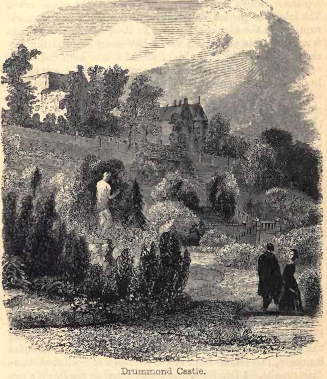
2. Of the country seats the
most distinguished is Drummond Castle (Lord and Lady Willoughby de Eresby)
four miles distant. The castle surmounts a rocky eminence, in the midst of a
park of the most spacious dimensions, "a waste of lawn and pasture" skirting
the ample sloping base of Turleum with its mantle of larch. Gentle hill,
shelving dale, and undulating slopes diversify the policies, which extend
two miles either way,
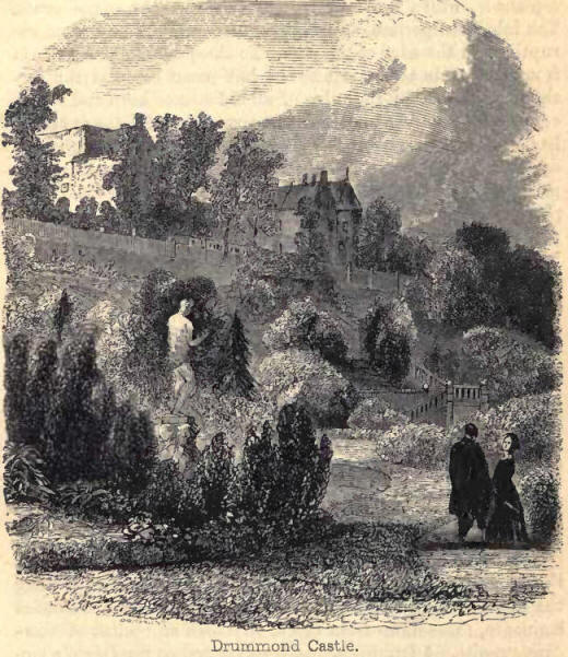
dotted with clumps and noble
avenues of aged timber. The pastures are alive with hundreds of red and
fallow deer, which gaze upon the stranger or bound away from his advancing
steps; while on the north an extensive artificial sheet of water, encircled
by fine oaks, with. foliage depending to the water's edge, presents its
troops of stately and graceful swans and other waterfowl. Matchless flower
gardens, well known by repute to every florist, lie on the south side of the
castle rock. Figures intricately mingled, but "not without a plan," and
mathematically cut in sward of velvet smoothness, interspersed with groups
of statuary, form an extensive level parterre, which is connected by a
shelving bank of shrubbery to a terrace and an esplanade, which leads by an
archway into the castle court. The inhabited portion, an irregular range of
building, rises abruptly from the edge of the rock. To the quadrangular
space in front, the main access is across a half-moon court at the further
end, formed by the ruins of an old square keep and its accessories, to an
arched outer entrance under which, the approach has been cut through rock.
Towering as it thus does above a demesne of such exquisite character, itself
the centre of an expanse of rich and profusely wooded country, with the
Grampians in sight on the north, Drummond Castle may well be pronounced, in
the words of Macculloch, "absolutely unrivalled in the low country, and only
exceeded in the Highlands by Dunkeld and Blair."
James the Fourth, the merry
and chivalrous monarch, frequently visited Drummond Castle, and the tragic
story of the fair but ill-fated Margaret Drummond is a well-known incident
in early Scottish gossip. Her present Majesty and Prince Albert also
honoured it with their presence in September 1842.
3. Strangers may be gratified
at Ferntower House, within a mile of the town, with a sight of Tippoo Saib's
sword, presented to Sir David Baird at Seringapatam, and of a great painting
by Wilkie of the "Finding of the Body of Tippoo" after the storming of that
important fortress, in which Sir David Baird bore a conspicuous part.
Among other of the delightful
walks and excursions which the neighbourhood presents, "Lady Mary's Green
Walk," along the banks of the Earn, conducts to Tomnachastle—a fine wooded
eminence, three miles from Crieff, on which an obelisk of Aberdeen granite,
84 feet high, hits been erected to Sir David's memory. The view from the
Knock of Crieff is also worthy of attention, and, if time permit, that from
the top of Turleum will be found still more commanding and interesting.
4. Before quitting this
locality we are tempted to wander a few miles further south, and make. room
for a somewhat detailed description of the celebrated Roman Camps at Ardoch,
in Strathallan, a district shelving down to Dunblane and the Bridge of
Allan, which, immediately connected as they were with the gallant and
patriotic struggles of our brave Highland ancestors, and unquestionably the
most entire specimen of Roman castramentation in Scotland, and we believe in
Britain, can hardly be deemed out of place. They are said to have been the
Castra, Stativa of Agricola, when on this side of Bodotria, skirmishing with
the hardy sons of Caledonia, under the leadership of Galgacus.
Since the opening of the line
of the Scottish Central Railway, the Greenloaning Station has been regarded
as one of the principal starting points to the Western Highlands of
Perthshire. To meet the convenience of travellers, stage-coaches ply thrice
a day to Muthil and Crieff, and private conveyances are also in attendance
on the trains. And the line of road leading between Greenloaning and Crieff
(11 miles), runs through a tract of country of great natural beauty—rich
with historical associations. Shortly after passing the village of Braco (1
mile), and ascending the rising ground beyond the bridge which crosses the
Knaick, the road leads right through the Camps.
The extensive space occupied
by the camps consists of four departments. The position was happily selected
for defence; on the west the Camp was safely protected by the abrupt steep
rising from the river Knaick, and having two fossae between it and the
banks; on the south by a deep morass, which extended a considerable way
eastward, with its two fossae also; and on the east and north by deep
intrenchments of five ditches and six ramparts parallel to the station; all
of which were doubtless amply sufficient to guard those within, and to ward
off the assaults of a besieging army. The area of the station within the
intrenchments may still be seen, and is of an oblong form, 420 feet by 375,
with its four sides nearly facing the cardinal points of the compass. The
place of the Prectorium or general's quarter is a regular square of sixty
feet in the side, in the rear or part furthest distant from the enemy; but
it is marked off rather irregularly, for on inspection it is not found to be
exactly in the middle between the gates, nor parallel with those of the
station. It is however elevated above the general level of the ground, and
appears to have been enclosed by a stone wall.
Within this, also there are
the foundations of a building 30 feet by 27, which gives some probability to
the conjecture that there was a place of worship once here, which is still
called the Chapel Bill. [There is a deeply imbedded subterranean apartment
which had probably been a water-tank, somewhere below the Pratorium, out of
which at one period a number of Roman helmets, spears, and other memorials
were recovered. But the search was interrupted by the foulness of the air.
The opening of the aperture having been afterwards shut up, all subsequent
attempts to find it have proved unavailing. Many stone coffins have been
found at different times in digging about the camps, or near them, and some
of the skeletons contained in them are said to have been of an uncommon
size. Among others in a stone coffin found about a mile west from the camps,
a skeleton, seven feet long ; and a mile and a half distant, in the Muir of
Orchil, another of the same length, to Cairn Woehil. These have generally
been in cairns or heaps of stones.]
Of the four gates which
belonged to the Roman Station, three only are now to be distinguished, the
fourth being scarcely traceable. Fronting the Praetorium is the Pratorian
Gate, crossing the north lines in an oblique direction. Opposite to that
gate, and behind the Praetorium where the Decuman Gate should be, is a road
leading out of the Camp, which may have been the Decuman; and onwards to the
right and left of the Prutorium are to be seen the two, which were called
principal gates, as being at the ends of the principal street which crossed
the camp in front of the Pratoriurn. Upon the Poly-bean system of
castramentation, this fort would accommodate 1200 men.
Immediately adjacent to the
north side of the station, is the Procestrium or Pro-castrum (for a camp),
or an addition to the other, as probably used by Agricola, for containing
his baggage, when he thought of dividing his army into three parts, in order
to watch the movements of Galgacus, and fight him from the neighbouring
hills. This Procestrium seems to have been strongly fortified, and a
subsequent work to the other, for part of the area of the Great Camp was
included in it ; but its intrenchments are levelled by the plough, while the
corner of the former is yet visible. Its south gate is also to be seen, as
connecting it with the station, and this again with the fragments of another
gate on the north side. It was of an oblong shape, consisting of 1060 feet
by 900, and capable of accommodating 4000 men.
North west of the Procestrium
is the Great Camp, so styled from its size. Its mean length is 2800 feet,
and its mean breadth 1950; it would, therefore, according to the Polybean
system, hold about 26,000 men; and this was what induced General Roy to
believe that it was in this camp that Agricola held his great army previous
to his dividing it into three bodies, in order to meet and conquer the
Caledonians.
The form of this camp is
oblong, but not so regular as that of a parallelogram—a fact which seems to
prove that the Romans did not adhere to mathematical nicety, where the
nature of the ground did not well permit. The public road to the north,
known of old as the military road, enters by its south gate, and so has cut
down one-half of the epaulment which covered it; but the other half still
remains rather entire. The north gate is a little east of the road, covered
by a straight traverse, and another gate on the west is in the same way
protected. On the east side, towards the north, there is a gate that has
been defended, not only by a square redoubt, within the lines, but also by a
clavicle—from which circumstance it may be supposed that a weak legion was
there quartered.
On the west side of this
Great Camp is a smaller one of an oblong shape. Its size is 1910 by 1340
feet, and it would afford accommodation for 12,000 men. To the antiquary
this one is very interesting, especially in tracing the itinera of Agricola.
It is evidently higher in position than the other camps ; one-half of it
lies within the other camp, which is adjacent to it ; and the fact of its
being left so very entire, would perhaps point to it as the abode of the
third part of the Roman army that remained with their leader, whilst the
others were encamped at Strageath, and Dealgin Ross, on the plains of Comrie;
for the entireness of the camp serves to prove that it was the last
occupied, and that Agricola left it in great haste with his third division,
to aid the ninth legion, who were then almost subdued, in the Camp of
Dealgin Ross. The camps are now enclosed within the grounds of Ardoch House,
and carefully protected from further dilapidation.
5. Leaving the camp, and
having gained the height to the north, the line of the military road formed
by General Wade presents itself, and runs in a direct line over the Muir of
Curry-over. Shortly afterwards the turnpike diverges to the right, and on
the summit of the Muir we reach the policies of Orchil House—(Gillespie
Graham). After an easy descent the road at Bishop Bridge crosses the river
Machany—a fine clearly-running stream, and noted in the district for its
excellent trout-fishing.
Surmounting another height,
we find ourselves at the policies of Culdecs Castle—(Speir). Here the
extensive plain, richly wooded, and studded with noblemen's and gentlemen's
seats—to the left the grounds of Drummond Castle, backed by Turleum, and the
lofty Ben Voirlich—in the foreground the village of Muthil, imbedded in
wood, with Crieff beyond, and the heights in front of which it stands,
overtopped by the Grampian range, present a landscape of extreme beauty,
variety, and grandeur. A mile further to the northward stands the thriving
village of Muthil, with its population of 1300 souls. The Old (formerly
Collegiate) Church is now roofless, but it still raises its time-worn tower
high over the venerable yews which encircle its choir. This pile, according
to Spottiswood, was built four centuries ago by Bishop Ochiltree. The tower
is one of those usually ascribed to the artists of the ninth century. [It is
square, and about 70 feet high, like that at Dunning, near Forteviot, the
Scoto-Pictish capital. The Brechin and Abernethy towers are narrow and
round.]
The parish church, standing
on a commanding site, is a fine specimen of the Gothic style. It was
finished in 1828, at a cost of £6900, and is conveniently seated for 1600
persons. Passing through Muthil the wayfarer enters the magnificent
avenue—composed of stately beeches, chesnut, and lime-trees—which embower
the road to Crieff (three miles) ; and here and there the eye is attracted
by a turret or a jutty of Drummond Castle half hid by the venerable elms,
"Whose boughs are mossed with
age,
And high tops bald with dry antiquity,"
which contest for a standing
place in the clefts.
TO AMULREE AND ABERFELDY.
6. Before entering on the
route to Lochearnhead, we may shortly notice the access to the Highlands by
Amulree. On the way Monzie (Campbell) is passed, in which the paintings and
armoury are worthy of observation, while the grounds are highly picturesque.
They contain a few of the first larches brought to this country by the Duke
of Athole, and, like those at Dunkeld, of great size—from eighteen to twenty
feet in girth. After passing Gilmerton, the road ascends a steep acclivity,
near the top of which a magnificent view westward, towards Comrie, is
displayed. We may observe, that along the direct Perth road are a succession
of fine seats and other objects of note—as Abercairney, (Major Moray
Stirling); the ruins of Inchaffray Abbey; Gorthy, (Mercer); Tippermalloch,
(Smythe); Methven Castle, (Smythe), near which Bruce was defeated, June 19,
1306, by Aymer de Valence, Earl of Pembroke; and Ruthven Castle—now called
Huntingtower—the scene of the Raid of Ruthven.
7. Proceeding onwards from
1lfonzie, the road passes for three miles along a bare moor, till the
picturesque grounds of Logie Almond (Paton) present their artificial
outlines, in the middle of wild mountain scenery. The road to Amulree
strikes to the left up the small glen. Another branch leads down Glen
Almond, passing Logie Almond, Gorthie, (Mercer,) and soon reaches the inn of
Cairnies, where good accommodation may be had, and whence the imposing
buildings of Trinity College may be conveniently visited.
The pass into the Highlands
possesses several rather remarkably bold and rugged features, and is worthy
of a passing visit. It is flanked on one side by hollow acclivities, passing
into huge impending rocks, and on the other by lofty cliffs quite
perpendicular—is about two miles in length, and in some places so narrow, as
barely to afford room for the bed of the river. In the bottom of the pass,
towards its upper end, is a large, nearly cubical, stone, which tradition
says formerly covered the tomb of Ossian, and which was displaced in 1746,
during the formation of the road, when a small chamber was found below it,
containing bones.
"Ossian, last of all his race,
Lies buried in this lonely place."
The highly-elevated summit of
the opening communicating between Straths Earn and Tay (where the inn of
Curriemucklach and the public-houses, with the church and manse of Amulree—situated
on the Braan, which descends to Dunkeldare found) is a dreary waste,
encompassed with low heathy hills. The distance to Dunkeld is ten; to
Tay-Bridge, at Aberfeldy, twelve miles.
TO LOCHEARNHEAD.
8. Between Crieff and Comrie
Stratbearn gradually narrows, and on the way we meet many country-seats. The
lower part of the valley is rich in corn-fields, which are lined off and
intersected by fine old trees, and flanked by hanging woods, while the
northern boundary partakes much of a mountainous character. Ochtertyre, (Sir
W. Keith Murray,) about two miles from Crieff, and Lawers House, (Mrs.
Williamson,) further on, are surrounded by noble woods. Between them,
Strowan (Graham Stirling) and Clathie (Colquhoun). Ochtertyre has acquired a
deserved celebrity for the romantic beauty of its situation. It occupies an
elevated terrace on the slope of a long wooded hill, skirted at the base by
a sheet of water of considerable extent, variegated with wood-clad islets.
The course of the neighbouring stream—the Turret—exhibits a variety of
much-admired scenery, rendered classical by the pen of Burns, who also,
while at Ochtertyre, wrote the blythesome song of "Blythe blythe and merry
was she," on the "Flower of Strathmore," Miss Euphemia Murray of Lintrose.
Loch Turret—a fine loch about seven miles distant from Crieff, overhung by a
bold crag, and embellished by a castellated lodge—lies embosomed among the
hills forming the frontier range of the Grampians. On the way, the tourist
should visit the Falls of the Borvick, and those of the Turret in returning.
The parks of Lawers boast, perhaps, the largest pine trees to be seen in any
part of Scotland.
9. Comrie is a populous
village, situated on the north bank of the Earn. It possesses a neat church
and spire. Cotton-weaving for the Glasgow manufacturers is the chief
occupation of the inhabitants. Half a mile south of the village, on the
level plain of Dealginross, are the remains of another Roman camp,
calculated to have been of a size sufficient to accommodate 8000 foot and
3000 horse. It is by commentators supposed to have been that of Agricola's
19th legion, who were surprised and defeated by the Caledonians, under
Galgacus, at the foot of the Grampians ; though the tide of victory was
turned by the attack on the Caledonians in the rear, by the forces from the
camp at Ardoch, already described. About a mile and a half behind the
village, a well-proportioned monument, about seventy-two feet in height, has
been erected to the memory of the late Lord Melville, overhanging a
turbulent little stream called the "humble Bumble." Near the monument is the
"Devil's Caldron," where the rivulet, at the further extremity of a long,
deep, and narrow chasm, is precipitated in a fall of some height. As it
escapes from its confinement, it tumbles over a second lower perpendicular
descent, and then, rushing down in a slanting curve, it leaps headlong into
a wide deep pool, half over-arched by two moss-covered rocks, which, falling
from above, have suddenly stopped, perching themselves on the very verge of
the gulf, and overhanging, on opposite sides, the darkened water. From the
monument the view is extensive, varied, and interesting.
The neighbourhood of Comrie
is remarkable for the frequent occurrence of smart shocks of earthquakes, by
which solid bodies have been made to vibrate, and lighter ones overturned.
The most severe shock which has occurred in the memory of the oldest
inhabitants, was that which occurred on 23d October 1839. They generally
happen in the wane of the moon, and are immediately preceded by a great
stillness of the atmosphere. [Those who may be desirous of making themselves
acquainted with these phenomena are referred to the Edinburgh Philosophical
Journal, 1841-42.]
10. Between the village of
Comrie and Loch Earn (five miles and a half distant), we pass Aberuchil
Castle, Dalchonzie, and the mansion of Dunira (Sir David Dundas, Bart.),
with its picturesque grounds and many pleasure walks. A little way east of
St. Fillan's, the strath becomes for a short space very narrow, and the
mountains seem to close in upon the traveller.
The pedestrian or horseman
ought to cross to the south bank of the river at the Bridge of Koss, for a
couple of miles. He will thus pass close to Abenichil Castle (Col.
Drummond), a high square structure, built in 1602, with a more modern
addition. It has witnessed many sanguinary scenes between the Campbells and
MacGregors. Avenues of lime, horse-chesnut, and other trees of great growth,
adorn the grounds. Dalchonzie is a name given to a sporting retreat,
consisting of a row of neat white-washed houses on the south bank of the
river. Dunira is the country residence to which the celebrated Lord Melville
retired from public life. It is a large square building, standing on a
spacious level lawn (north side), encompassed by lofty and wooded mountains.
In the house is to be seen a curious and costly jewel casket of Hyder Ali.
11. The village of St.
Fillan's, at the east end of Loch Earn, is one of the neatest in the
Highlands. It consists of about fifty houses, of one story each, but almost
all of which are slated, and extending from the inn at the end of the lake,
partly along the river and partly along the lake side. Most of the houses
used to be ornamented in front with ivy, honeysuckle, and other creepers,
and each house has a narrow stripe of ground enclosed, on either side of the
door, decorated with laurel and flowering shrubs. But we regret to find that
the inhabitants are not careful to retain their reputation for the tidiness
and taste which used to distinguish their dwellings. At the west end there
are some very neat houses, with gardens in front. St. Fillan, who had been
prior of Pittenweem, was Robert Bruce's favourite saint. One of his arms was
borne in a shrine by the Abbot of Inchaffray, at the battle of Bannockburn.
This arm is now in North America, in the possession of a man named Dewar.
Ibis well here, as well as in Strath Fillan, was, in the memory of the
present generation, deemed efficacious for the cure of many disorders.
An islet, at the foot of Loch
Earn, was at one time the retreat of a bandit family or sept of the name of
Neish. On one occasion they ventured to plunder some of the clan Mac Nab,
who lived at the west end of Loch Tay, while on their way from a foray in
the low country. The chieftain despatched across the hill a party carrying a
boat with them, and commanded by his son, a doughty personage, known by the
appellative of smooth John Mac Xab, who surprised the marauders by night,
put them all to the sword, and exterminated almost the whole Sept of the
Neishes, and carried away in triumph the head of the old father of the
caterans. Hence the Mac Nab's motto, "Dread nought," with their crest, a
man's head, are said to have been assumed in commemoration of this event.
12. Loch Earn is only between
six and seven miles in length. The hills on the north are pretty lofty, but
without marked inclinations. MI`Culloch, who is a great authority, gives
Loch Earn unqualified praise. Iie regards its style as that of a lake of
much larger dimensions and yet complete in itself, and not to be regarded as
a reduced copy. It has not impressed us so forcibly, yet there is
considerable truth in his eulogium. Good views are obtained from the
extremities. As on Loch Tay, the northern hills are of more decided
character than the opposing ones.
Should the traveller incline
to shape his route eastward by Loch Earn side, the southern road is to be
preferred, as it affords a fine view of the scenery stretching to the north.
From within a mile and a half of Lochearnhead, it will be found to pass
through continuous woods of oak, larch, ash, and birch, with oak copse, and
brushwood beneath. The finest landscapes occur about midway, a little to the
cast of the house of Ardvorlich (- Stewart), where trees of various sizes
overhang the water, and short wood-fringed promontories projecting into the
lake, with gracefully sweeping arms of little semicircular bays, bordered
with trees, afford a pleasing foreground and a sufficiency of ornament,
while of the water and opposite hills only limited sections are necessarily
embraced by the eye. Ben Voirlich rears its lofty head behind Ardvorlich;
and the still celebrated Deer Forest of Glenartney spreads around its
eastern base. [For an account of the well-known incident founded on in the
Legend of Montrose, and the subject of Clan Alpin's vow—a spirited piece of
poetry by Alexander Boswell, sec p. 87.] Rather more than a mile and a half
from the inn of Lochearnhcad, we come to the Castle and Falls of Edinample.
The former, near the loch and burn side, is a high square building, with a
round tower bulging out from each of two opposite corners. It belongs to the
Earl of Breadalbane, and is kept in a habitable state of repair, and is now
the residence of Campbell, Esq. The falls are immediately below the road,
and are approached on the east side of the rivulet. Pouring over a broad
rugged rock, in two perpendicular streams, on each side of a narrow
interposing fragment, the waters unite about midway, and, slanting forward,
complete the descent by a second vertical leap ; the whole height apparently
being about sixty feet. On the opposite side of the pool, below the fall,
the bank rises in abrupt rocks, surmounted by a wooded slope, from the edge
of which slender ash trees project. The other bank ascends in a receding
tree-clad acclivity. Airy birches crown the high broad cliffs above the
fall, and behind them are seen the sombre walls of an old burial vault.
Opposite Ardvorlich, on the north side, is a valuable lime quarry, which has
tended greatly to the agricultural improvement of the district.
13. The Loch Tay road
branches off from the main one, between Stirling and Fort-William, at a
point about six miles distant from Lochearnhead, and rather more than two
from the village of Killin, at the west end of Loch Tay. This lake is
fifteen miles in length by one of general breadth. On the north side it is
encompassed by a chain of bulky mountains, rising towards the west and
centre, into bare and lofty, but gracefully outlined heads, of which Ben
Lawers, the most elevated of the Perthshire hills, towers pre-eminent. [This
mountain is well known as an excellent botanical habitat. its Height is 4015
feet.] The opposite heights differ in outline, being of a soft and regular
form; and on both sides the mountain ranges are well clothed with heath and
pasture, but little broken with naked rock. At the head of Loch Tay, two
glens, Dochart and Lochy, separated by a broad range of hills, unite. From
the termination of the intervening barrier, a cultivated plain, about a mile
square, extends to the extremity of the lake. The line of hill ground,
intermediate between the two valleys, descends in a long waving ridge, whose
sides are clothed more than half-way down with a dense larch wood. Between
the hills which border on Loch Tay to the south, and the western portion of
the lake, a lower tier ascends in successive eminences, profusely chequered
with oak, birch, pine, larch, and beech. Upon the north the plain is
immediately succeeded by broken ground, wooded as the opposite hills. The
river Lochy, from this side, sweeps across the level at the foot of the mid
range, and proceeds to join the Dochart, in a still, all but motionless
stream.
Killin, the burying place of
Fingal, is much admired for its numerous landscapes. The village, a long
line of stone and lime huts, thatched with heath, extends in opposite
directions on both banks of the Dochart, before it is joined by the Lochy.
The river at Killin rushes over a widened and shelving channel, and
encircles two islands immediately above one another. From the upper end of
the lower, three small bridges cross the stream. This island is some two
hundred yards long, and is surrounded by a grove of tall magnificent pines,
from six to eight feet thick ; the upper islet is also crowned with similar
pines. These objects, with the houses and mills of the village, afford a
multiplicity of foregrounds to the noble views of the huge sides and lofty
twin summits of Ben Lavers and the contiguous mountains, and, looking to the
westward, of Ben More's sharper peaks.
14. On the north side of the
plain above alluded to, rather more than a mile and a half from the village,
stand the ruins of Finlarig Castle, (an ancient seat of the Breadalbane
family,) in an undulating park, surrounded by gigantic sycamore and other
trees of remarkable growth. The castle, a narrow, three-storeyed building,
with a square tower at one corner, is entirely overgrown or faced with ivy ;
and though the walls have mainly fallen, and the building be small, it forms
a picturesque ruin. Immediately adjoining is the family vault.
On the occasion of a marriage festival at
Finlarig, in years gone by, when occupied by the heir-apparent, intelligence
visas given to the company, which comprised the principal youth of the clan,
that a party of the Macdonalds of Keppoch, who had just passed with a drove
of lifted cattle, had refused to pay the accustomed road collop. Flushed
with revelry, the guests indignantly sallied out and attacked the Macdonalds
on the adjoining hill of Stronoclachan; but, from their irregular
impetuosity, they were repulsed with loss. Tidings of the affray were
conveyed to Taymouth; and, a reinforcement arriving, the victors were
overtaken in Glenorchy, and routed, and their leader slain.
Three miles from the inn, on the Lochy, are a
series of waterfalls, well worthy of a visit. Glen Lochy throughout the
space below them is a wide open valley, divided into large cultivated fields
; fine woods of oak, birch, larch, and beech extend above, and some large
plane and ash trees overhang the road. The falls are six in number, arranged
into two groups, separated by a deep clear pool, and they are flanked by
oak-surmounted rocks. They vary from four to sixteen feet in height; and, as
the whole are seen at once, form a very pleasing series of cascades.
15. A road branches off on either side of Loch
Tay. The southern keeps high on the face of the hills, touching the edge of
the water but twice, till within a mile and a half of Kenmore : this is the
preferable route, on account of the superior characters of the opposite
mountain range, and the occurrence near Kenmore of the falls of Acharn. A
good deal of cultivation is seen on either side, and a considerable number
of hamlets, particularly on the north. The wood is chiefly confined to the
extremities of the lake, but its obtuse promontories are lined with drooping
ash trees. In the rich foliage on the south, adjoining Killin, stands
embosomed a residence in which the Marquis of Breadalbane resided when Lord
Glenorchy. The eastern section of Loch Tay is bounded on the north by
Drummond Hill (distinct and separated from the chain of Ben Lawers, by which
the rest of that side is bordered), which reaches for three miles along the
loch, and to a like extent down the river Tay; its steep southern acclivity
clothed throughout with a dense magnificent forest of pine, larch, and hard
wood. Two miles from
Kenmore, on the south side of Loch Tay, are the Falls of Acharn, half a mile
off the road. The path which leads to them strikes off on the west side of a
small bridge, where there is a mill and some slated houses, and ascends
right up the hill face. A gate on the bordering dyke leads to the edge of a
high rock ; and an artificial dark passage conducts into a neat hermitage,
commanding an excellent view of the fall. The burn, precipitating its waters
over the side of a deep and wooded dell, first performs a perpendicular
descent of fully fifty feet, separating towards the bottom into two vertical
streams, which are caught by a small basin ; whence the water escapes by
successive inclined leaps, the whole forming a cascade apparently about
eighty or ninety feet high.
16. At the east end of Loch Tay the traveller
reaches the village of Kenmore, and the much-admired environs of Taymouth
Castle. The valley is here of moderate breadth. As already noticed, the
eastern portion of Loch Tay, and the river issuing from it for the first few
miles of its course, are bounded on the north side by a long wooded eminence
called Drummond Hill. The corresponding hills on the south side, for the
first two miles, rise in a moderate acclivity, richly wooded with oak,
birch, and larch. Above this broad belt of wood, a gentle arable slope
supervenes, rounding off at top in a prolonged, nearly level, summit, partly
covered with larch trees. Further east, the continuation of this the
southern range inclines from the wooded bank of the river, in a lengthened
slope, laid out into extensive parks, divided by straight rows and belts of
wood, and the surface of the ground above is chequered over with small
formal clumps of larch. The river issuing from the north end of the lake
keeps the same side of the valley for about two miles ; when it makes a
sudden sweep to the base of the opposite hills. The space thus enclosed for
two miles on the south side of the river is, for a third of its length, that
next the lake, broken into gentle undulations ; and the remaining portion
presents a triple series of level terraces, gradually lowering from the
west. On the most easterly terrace stands Tay-mouth Castle, the seat of Lord
Breadalbane. The village of Kenmore, at the end of Loch Tay, consists of an
inn, and about a score of small houses (a few of them bedecked in front with
ivy, honeysuckle, virgin's bower, and sweet-briar), occupying in a wide
double row the slope of a small peninsula, formed between the river and a
creek, or prolongation of the lake, and surmounted by a church, with a neat,
square, white-washed spire.
At a distance of three miles from the lake, the
Tay is joined by the river Lyon, which has its source in the district of
Fortingal, to the north of Drummond Hill. Its mouth forms the limit of the
pleasure-grounds of Taymouth, which encompass a circuit of thirteen miles.
Along the north bank of the Tay there extends a
continuous row of stately beech trees, two miles in length, over-shadowing a
terraced walk of shaven turf, sixteen yards wide, extending between it and
the river. For a mile from Kenmore, on the opposite side, a corresponding
row of more aged beech, screen with their umbrageous foliage a similar
promenade. Many fine sycamores occur at intervals by the edge of the water,
and behind the castle the winding stream is skirted by an avenue of very old
lime trees; and the extremities are connected by a continuation of the same
in a straight line, the whole forming a continued Gothic arch for the space
of a mile. These magnificent trees, the growth of centuries, are of unusual
height; and their lower branches, spreading far out, form sort of
side-aisles to the fine central arched way. The rest of the lower surface of
the valley is sprinkled with aged beech trees, one of which is twenty-two
feet in circumference. Taymouth Castle looks to the south; and at the base
of the wooded hills in front are some gigantic and picturesque horse-chesnut
and ash trees, as well as several uncommonly straight and beautiful larches,
fourteen feet in girth, and a hundred and thirty feet high. A great
proportion of the very varied trees have attained large dimensions. We may
further particularize an ash behind the inn at Kenmore—a beech at the
saw-mill--and a lime tree nearly in front of the castle.
This castle is a very large ashen-coloured
quadrangular pile of four storeys, with round corner-towers, wings two
storeys high at opposite corners, and one of them a rather incongruous
remnant of the old castle, and terminating in an airy central pavilion, 150
feet in height. A light stone balcony encircles the lower storey, which is
crenulated, as is also the roof. Some ancient armour from the time of Henry
II. to Cromwell's, may be seen in the entrance-hall, and the coup d'oeil of
the pavilioned staircase is striking. Some of the rooms, as the baron's
hall, dining, drawing, and Chinese rooms, are worthy of notice, and possess
several valuable specimens by the old masters ; and on the occasion of her
Majesty's visit, a large outlay was made in the way of permanent decoration,
and many costly articles were added to the furnishings.
The disposal of the pleasure-grounds about
Taymouth Castle has been censured as much too formal and constrained ; and
there is some room for the remark : but they possess great beauty, and, it
must be allowed, no small degree of grandeur, especially as conjoined with
the bold and commanding features of the adjoining alpine scenery. The view
from the vista-fort, in the face of the hill, directly fronting the castle,
is reckoned one of the finest in Scotland. In the centre of the landscape a
portion of the lake widens towards the spectator. On the Ieft, two long hill
slopes, partly wooded, rise from the water, one above another; to the right,
Drummond Hill sends down its wooded sides, and behind it rises the gigantic
bulk of Ben Lawers, stretching away, in a prolonged oblique direction, to
the remote distance, Ben More also shooting up from the extremity of the
range his conical summit. At the near end of the lake rise the houses and
church of Kenmore, embosomed in trees; and to the north of them a handsome
bridge of seven arches is seen spanning the Tay, "revolving sweet in infant
pride," and beyond it, a little wooded island, in which Sybilla, queen of
AIexander I. is interred. The immediate foreground is filled up by the
termination of the tree-studded park. But a view, perhaps better adapted for
the pencil, is that obtained from Lady's Mount, the first rise in the ground
near Kenmore, where, with the same background, the near objects are more
distinct, and the picture less complicated and extensive. The scenery is
distinguished by the very long and remarkably gentle slopes around the
extremity of the lake—the rounded shoulders and elongated outlines of the
hills—and the encircling zone of cultivated ground, variegated with trees.
A fanciful dairy, on a wooded eminence above the
river, midway between the castle and the village, is not unworthy of a
visit, partly on account of the commanding view it affords of the park and
Iake—the latter presented through a vista of foliage; and perhaps preferable
to either of those already indicated. The dairy is a square or cross-shaped
structure of two storeys, of protruding white quartz stones, with projecting
roofs of slated and rustic work, and encircled by rustic pillars, and a
verandah covered with flowering creepers, and a parterre of flowers—the
porticoed entrance-floors paved with marble, and the milk rooms and lobby
flagged with a fine freestone inlaid with black marble. The walls of this
ornamental little dairy are faced with polished yellow Dutch tiles, and the
milk dishes are of brown china.
The grounds of Taymouth are remarkable for the
number of zoological curiosities congregated within their ample bounds
—several varieties of sheep, all our native deer, and specimens of the emu,
bison, buffalo, the white Caledonian cattle, and the once indigenous
splendid capercailzie.
The brilliant effect may readily be conceived of the illumination, when her
Majesty was feted here in a style of splendour which could hardly have been
surpassed; the whole woodland one blaze of variegated light—the wire fence
of the deer park festooned into a girdle of fire—the vista-fort illuminated
by 40,000 lamps—the mountain tops kindled up into so many lustrous beacons,
and a magnificent display of fireworks adding gorgeous coruscations to the
fairy scene, amidst which a vast assemblage wandered about, deeply impressed
and strangely excited by the unwonted presence of royalty, and the
rare-demonstrations of costly hospitality on the part of the noble host.
Lord Breadalbane's estates are very numerously
peopled by small tenants, who hold their possessions at will, without
leases. 17. On the
north side of Drummond Hill lies an open and partially-wooded valley, called
Fortingal, extending for about seven miles from Loch Tay side to Strath Tay,
through which the river Lyon pursues its course to the Tay. This river flows
into Fortingal from Glen Lyon, on the north side of Ben Lacers, and the
connected hills which border on Loch Tay. About three miles from the lake,
and six from Kenmore, and on the north side of the river, is the Kirkton of
Fortingal—a few slated houses and thatched huts around the church. The
churchyard is remarkable for the remains of an enormous yew-tree, which
furnished many a goodly bow when that weapon formed a part of a Scotsman's
armoury. This is a very singular tree: it has been calculated by eminent
physiologists to be 2500 years old. About a century ago, the trunk was
single, and measured fifty-$ix feet : now it presents the appearance of two
stems, about twelve feet high ; of these the largest, which is quite hollow,
is twenty feet in girth. Though so much decayed in the core, it is
completely sprouted over with young branches. To the west of the Kirkton the
Lyon is crossed by a bridge ; at Comrie, three miles in the opposite
direction, a boat supplies the place of another, now in ruins. It may be
almost needless to observe, that the pedestrian can reach Fortino l by
crossing Drummond Hill immediately above Kenmore. In the space between
Kirkton and the boat of Comrie, the Lyon presents some fine studies of river
scenery. A mile below the Kirkton stands the house of Garth, surrounded by
fine avenues of trees; and about the same distance onwards the road crosses
the Keltnie burn, a little beyond which is the inn of Cushiville. The river
is throughout lined with spreading oaks. Comrie's old castle, consisting of
the shell of a small oblong building, of three storeys, with a square
addition projecting at right angles at one end, next appears, surrounded by
fine sycamores. The Lyon forms a junction with the Tay, about three quarters
of a mile below its walls.
18. Glen Lyon is connected with Fortingal about
a mile above the Kirkton, by the pass of Chesthill, which is well worthy of
being explored. This section, which is much inflected, is bordered on the
south by hills rising in green steep acclivities, with rocky spaces
interspersed. The opposing mountains are bold, lofty, and lumpish, and swell
into massive rocky and heathy summits. At the commencement of the pass,
their bases bulge out, forming to the shelving river a steep bank covered
with fine beeches. Towards the further end they send down, across the glen,
to the river and deep indented hollow of the opposite range, a series of
broad rocky hills These are covered to the water's edge with very large
beech, elm, oak, ash, spruce, birch, and sycamore trees. Beyond this rich
space Glen Lyon stretches away for a distance of nearly thirty-five miles
towards Tyndrum. It is a remarkably fine pastoral valley—very narrow, seldom
above a furlong in width, and at times barely admitting the passage of the
river; and it is hemmed in by hills of considerable height, much furrowed
with water-courses, forming, in rainy weather, so many continuous cataracts,
several hundred feet in height. Meggerney Castle was built in 1579, and is
approached through an avenue of a mile long, between rows of magnificent
beeches and limes, winding along the banks of the river Lyon, and screening
the castle till it bursts upon the sight at the extreme end of a fine lawn.
" Opposite the castle is an island, which, when seen from the east, has the
appearance of a heart, lines of tall beeches fringing it on either side, and
dipping their branches into the silent stream below. Beyond is a picturesque
wood of weeping birch, beech, elm, and lime trees, and the landscape formed
by the mellow and varied tints of their foliages surpasses the most finished
mosaic, just as much as nature usually transcends art." There are several
remains of circular forts of Fingalian masonry without cement, some of them
of 60 feet inside diameter, and the walls generally eight feet thick, though
it is conjectured that they had not probably exceeded twelve feet in height
; but they seem to have had several compartments, extending into the inner
area. A little below one of these is Clach Chonabhachan, in the braes of
Glen Lyon, a perpendicular slab four feet high, with a rectangular slab
projecting from within twelve inches of its apex. "The virtue which this
stone possessed was peculiar. Married ladies in an 'interesting situation'
were carried to it by their husbands. If their fair proportions were
embraced by the slab, they were assured of a favourable confinement ; if
otherwise, they must prepare for a fatal one. An unfortunate female
subjected to the test proved a world too wide for the shrunk aperture, and
her gudeman, in digging away the earth to widen the trench, destroyed the
virtue, and killed his wife." At the west end of Fortingal, and to the north
of the river, there was a Roman camp, of which the Prutorium is still
entire. Hard by is a large tumulus, which possibly could a tale unfold.
19. Near the inn of Cushiville a road ascends
along the banks of the Keltnie Burn, crossing the hills intermediate between
Straths Tay and Tummel. At Tummel Bridge, nine miles from Cushiville, the
road is continued onwards to Dalnacardoch (ten miles distant), where it
joins that from Perth to Inverness. In journeying northward from Cushiville
the road ascends along the edge of a deep and wooded dell, bordered by
sloping cultivated ground, for about two miles, and crosses the hill to
Tummel Bridge, through a wide elevated pass between heathy hills. About a
mile and a half from the low fields, the ruins of a high square keep called
Garth Castle, on the banks of the Keltnie, serve as a good foreground to a
variety of interesting landscapes. It stands on a narrow, rocky promontory,
between two rivulets, which, approaching in deep perpendicular channels, at
nearly right angles to one another, have almost met at the narrowed neck of
this promontory ; but the upper one, deflecting a little aside, leaves an
almost inaccessible projection for the site of the stronghold. It forms a
prominent object in the views which are obtained, either Iooking up the
confined channel of the burn, or from the rising ground above, whence we
look down upon a long shelving valley, ascending in easy irregular slopes
from the deep imbedded burn, which is over-canopied by slanting trees.
At the top of the ascent, about half-way from
Cushiville to Tummel-Bridge, a good country-road on the left hand conducts
to Kinloch Rannoch, thirteen miles distant from Cushiville. Leading along
the hill-face, to the base of the upper acclivity of Schehallion, it
descends into Strath Tummel, about three miles to the east of Kinloch
Rannoch. Loch Rannoch (eleven or twelve miles long, and better than a mile
of average breadth) is a straight sheet of water, bordered on the north by
long low eminences of gentle slope, and regular unbroken outline. The hills
on the south are higher and steeper: they stand apart from one another, and
in the centre are removed from the water's edge ; and the breadth between
the summits on the opposite sides of the loch is not short of twenty miles.
One continued forest of natural birch and fir, called "the Black Wood of
Rannoch," mantles the south side, from the margin of the water half-way up
the mountains, and a tolerably good road encircles the lake. The waters of
Loch Rannoch abound in trout of a very unusual size, being sometimes caught
of thirty pounds weight. From the head of Loch Rannoch Loch Erochd stretches
for sixteen miles towards Dalwhinnie—a dreary sheet of water, about a mile
of general width. The village of Kinloch Rannoch, at the cast end of the
loch, consists of half a-dozen huts, and an inn on the south side; and about
a score more huts and another inn, a church and a manse, on the opposite
side of the river Tummel, over which a bridge has been thrown.
For three miles below Kinloch Rannoch, the
surface of the valley is quite flat, and upwards of a mile wide, consisting
of a mixture of meadow and cultivated land. The advancing side-ridges of
Schehallion, and a broad terrace or eminence on the north, then fill up the
valley, leaving, for about two miles, room only for the passage of the
river, the banks of which are wooded with birch, larch, and fir. Mount House
(Robertson of Struan, chief of the Clan Donachie) occupies the upper end of
this obstructing terrace; and above it, on the sides of the strath, are the
houses of Milltown, (M'Donell); Crossmount, (Stuart); Dalchosnie,
(Macdonald); and Inverchallan, (Stuart). Afterwards, the glen again becomes
level, and continues widening till we reach Loch Tummel, ten miles distant
from Loch Rannoch. Tummel Bridge Inn, a comfortable house, where the road
from Crieff to Dalnacardoch crosses, is seven miles from the latter lake.
Loch Tummel is three miles long, and at the west end about two-thirds of a
mile in width, contracting towards the opposite extremity. Several obtuse
little promontories, sweetly fringed with ash, project into the water. The
hills along the upper portion of the strath are of gentle inclination and
moderate height; those on the north preserve nearly an unbroken level
outline. The southerly ones exhibit low detached summits, but rising from a
common continuous chain. In the slight depressions of the hill-face, a good
deal of land has been brought into cultivation, and the greater part of the
north side of Loch Tummel is arable. Birch is scattered here and there, but
heath and grey stones occupy by far the largest portion of the ground. As it
approaches Loch Tummel, the tortuous river is skirted with ash trees. Near
its mouth the house of Fosse (Stuart) stands on the south side of the
valley. The space of four miles from Loch Tummel to the Garry is a very
deep, confined pass, while the north side ascends very steeply from the
water, and to an imposing height, swelling out above into a continued
succession of rounded cliffs, with intermediate receding acclivities, the
whole clothed with birch, but mingled with some fir and larch trees. The
opposite side is of much the same, though less-strongly marked characters.
On the face of the north side stands the house of Bonskeid, (Stuart). A few
hundred yards from where it joins the Garry, the river Tummel forms a small
water-fall deserving of a passing visit. It is divided into two streams by a
small rock, on each side of which it pours for a few feet perpendicularly.
Rushing furiously forward, they reunite, and, in contracted volume, dash
obliquely over the remaining descent, the whole height not exceeding twenty
feet. At the east end of Loch Tummel, the pedestrian should cross to the
south side of the pass, by which means the scenery will he viewed to rather
more advantage than from the other side, and he can afterwards be ferried
over to the Dunkeld and Blair road at Portnacraig, opposite Pitlochry, three
miles below the fall, or two miles farther down the river, at Moulinearn,
The North Road crosses the Garry, at the bridge of Garry, near the lower end
of the Pass of Killiecrankie.
20. Returning now to the Tay. Below the junction
of the Tay and Lyon the valley of Tay becomes of considerable width, being
at Aberfeldy (six miles from Kenmore, and eight from Kirkton of Fortingal)
about a mile and a half broad. It winds in long gentle sweeps, and is for
several miles quite flat and cultivated. Between five and six miles from
Kenmore, on the north side, stands Castle 'Menzies, the seat of Sir Robert
Menzies, at the foot of a lofty range of rocky hills, rising in successive
tiers of perpendicular precipices, having noble oak and beech trees rooted
in their ledges, and the less abrupt acclivities covered over with hard
wood. The castle was erected in the sixteenth century. Like many buildings
of that age, it presents a high roof, small windows and turrets, and
consists of an oblong building, to the two opposite corners of which is
added a tall square wing, at right angles, one advancing in front, the other
retiring backwards. It is surrounded by a park, filled with aged trees,
rivalling in dimensions those of Taymouth. At the end of the park is the
respectable inn of Weem.
Opposite Aberfeldy the river is crossed by one
of General Wade's bridges. A tapering obelisk over each corner of the
central arch, about twelve feet above the high solid parapet, produces a
singular but picturesque effect.
21. Aberfeldy is a village of considerable size,
chiefly of one long street, with another leading off about the centre, and a
small square at their junction; the houses of one and two storeys, and
slated, but cold and comfortless looking, from the small and unlintelled
windows; but the stream which passes through it exhibits the most beautiful
series of waterfalls, perhaps, in Scotland. The lowest of the falls of
lioness is a mile from the village; the upper—for there are three—half a
mile beyond it. The dell in which these falls occur is apparently from 200
to 300 feet deep, and exceedingly confined, so much so that the trees, with
which it is filled, in some places almost meet from the opposite sides. The
wood forms a perfect thicket, and the walk is completely shaded from the
sun. The lowest falls consist chiefly of a series of cascades, formed by a
small tributary rivulet pouring down the east side of the dell, and
seemingly altogether about eighty feet of perpendicular height. These join
the main burn at the base of a little fall, which forms a conspicuous object
in the sweet view obtained from the channel of the stream. From the end of a
clear pool, where the motion of the water is indicated only by the bells of
foam gliding slowly down, the spectator sees, at the further extremity of a
low narrow chasm of black moistened rock, the small waterfall, at such a
distance that its noise reaches the ear in a soft lulling murmur. On either
hand rise high sloping banks, adorned with trees. A sweep of one side of the
dell terminates the opening with a steep face of wood. From the edge of the
fall shoots up a long slender spruce, succeeded by straight elms, and leafy
beech trees. Young drooping ash trees, from the opposite bank, dip their
tapering branches in the pool ; each little protruding rock is covered with
moss, and curtained with pendent ferns. Through the trees the other
streamlet is beheld descending in sidelong haste.
Let the visitor, however, hasten on to the next
series, for they demand particular examination. They consist of a succession
of falls, comprising a perpendicular height of not less than a hundred feet,
and occupying in length a space of considerably more than the like number of
yards. A prolonged sheet of descending water, alternately perpendicular and
slanting, is before us. From the edge of this lengthened cataract rise
abrupt rocky acclivities, covered with moss and ferns, whence shoot up tall
slender ash and elms. These partially veil two lichen-clad mural cliffs,
converging towards the uppermost of these falls, above which they rear two
high vertical lines; on the top of these cliffs nod serried groves of pine
and larch, while a row of airy birches wave on the slanting summit of the
bank which closes in the rocky gap. The last and highest cascade is a
perpendicular fall of about fifty feet, but possessing no peculiar interest.
Here a rustic bridge conducts across the dell, and affords the traveller the
opportunity of varying his route back to the inn.
22. From Aberfeldy the Tay maintains an easterly
course for nine or ten miles, till it is joined at Logierait by the river
Tummel. The hills, bordering this portion of Strath Tay diminish to a
comparatively low size. Irregular terraces occupy the bottom of the central
portion of this section of the valley, which above and below this space is
Ievel and open. The hill sides rise in undulating slopes, all more or less
cultivated, and frequently wooded to the top, especially on the north side,
on which also a succession of substantial-looking residences present
themselves, as Blackhill, Daltulich, Cloichfollich, Pittencree, and
Bolechine, the seats of families chiefly of the name of Stewart. Three miles
below Aberfeldy, Grandtully Castle (Sir William D. Stewart of Murthly),
stands by the roadside surrounded by rows of stately elms. It is an old
structure, but kept in a habitable condition. From each of two contiguous
sides of a large oblong building a tall square narrow addition projects at
right angles. An extinguisher turret surmounts the two free corners of the
main building, and a sort of round tower or section of one, containing the
staircase, bulges out behind, and projecting .high above the castle,
terminates in a pointed roof. One of the square wings is completely
encompassed with ivy, and the whole of almost uniform outline. The great
novelist states, that this building bears a close resemblance to the house
of Tully Veolan, the picturesque abode of the old Baron of Bradwardine. Four
miles from Grandtully is the inn of Skitewn, or Grandtully Arms; and half a
mile on, the small inn of Balnaguard.
About eight miles above Dunkeld, at Logierait,
the Tay is joined by and bends to the southerly course of the Garry and
Tummel, and the conjoined stream may be crossed by a good chain-boat. A wide
cultivated flat occupies, to within three miles of Dunkeld, the bottom of
the valley, through which flow the combined waters of the Tay and Tummel. It
is skirted by a terrace, on which various hard wood trees and oak coppices
abound; while continuous and very extensive masses of larch stretch along
the summits of the hills above, and below them cultivated fields slope
gently down. Six and a half miles from Dunkeld we pass Kinnaird House (Duke
of Athole's), and a mile and a half beyond Dalguise (Stewart).
Above Dunkeld, Craigiebarns, a massive rocky
mountain advancing from the hills on the eastern side of the valley, almost
blocks it up. This, with the opposite hill, Craigievenean, are clothed with
a dense pine forest, through which occasional glimpses exhibit large masses
of abrupt rock. Between them lie the rich woods which form the pride. of
Dunkeld. |