|
Roads; Falls of Kilmorack;
Old Church; Manse; The Drhuim; Isle of Aigas, 1.—Approach to Strathglass;
Eskadale; Erchless Castle; Clan Chisholm; their late Chief, 2.—Beaufort;
Fort Lovat; The Fentons; Grahams; Bissets; Sieges under Edward I. and
Cromwell; Accommodations of the Eighteenth Century, 3.—Belladrum;
Glenconvinth; Ferries, 4.—Strathglass; Ancient Pine Forests; Lead Mine;
Cross Roads to Urquhart; Bridge of fnvercannich; Bridge and Chapel of
Fasnakyle; Dun Finn, 5.—Geusachan; Termination of the Road; State of the
Country in 1745, 6.—Passes to the West Coast; Tracks, or Footpaths;
Mountains on the Boundary between Inverness and Ross shires, 7.—Glenstrathfarar;
Loch Miulie; Loch Monar; Great Deer Hunt, 8.—Scournalapich, and other
Mountains and Valleys, on the route to Attadale, on Loch Carron; MacRaes of
Kintail, 9.--Glen Cannich, 10.—The Chisholm's Pass; Falls of the Glass;
Knockfin, 11.—Loch Benneveian, 12.—Loch Affrick; Resting houses of Culivie
and Annamulloch, 13. Mam Soul; Glaciers, 14.—Strath Affrick; Glen Greenivic;
the Beallach; Crowe of Kintail; Falls of Glomak; Characters of the Scenery,
15.
1. WE proceed to give in this
route a short account of the upper portion of the river Beauly, including
the valleys of Strathglass, Glen Cannich, and Glenstrathfarar, and the
passes through them to the west coast, all of them being very interesting.
Returning to Lovat or Beauly
Bridge, a road, as formerly mentioned, has been carried westward along the
north bank of the Beauly, through the parish of Kilmorack, (the
burying-ground of St. Marion), to the summit of the first-mentioned strath,
which is about twenty-five miles distant. Another road nearly parallel to
it, already referred to, runs on the opposite side of the river, through the
parish of Kiltarlity ; both uniting at the bridge of Fasnakyle, in
Strathglass.
The lower falls of Kilmorack
are situate about two miles west from Beauly, immediately beneath the parish
church. They are less remarkable for their height, than for breadth and
quantity of water, and, fox the beautiful accompaniments of lofty rocks,
smooth green banks, and hanging woods which encircle them. The river,
dashing from between two lofty precipices, where it is confined to an
extremely narrow channel, suddenly expands into an open semicircular basin,
through which it slowly glides, and is then precipitated over its lower edge
in a series of small cataracts. These falls are not sufficiently high or
powerful to prevent salmon from getting up the river ; but the rocks next
the shore being accessible, the fish are often caught by men who stand
watching them, with hooks or spears fixed to long rods, and with which the
salmon are seized when in the act of springing over the cascades. It is
obvious that the sport is a dangerous one; and many a stalwart Highlander
has met his death by it. Below the falls, the stream flows on through a rich
plain, overtopping which Beaufort is beheld to great advantage; and close
by, on the further bank, the visitor will perceive the ruins of the old
church and the deserted manse of Kiltarlity, with the small adjoining
burying-ground, which, as being the resting place of their forefathers, is
still resorted to by the parishioners. On the Kilmorack side, the same
objects of human mortality and affection are still more picturesquely
situated; the church and manse stand on a green bank a little above the
road, but the burying-ground has been perched on the brink of the precipice
overhanging the river.
Part of the same bank has
been enclosed for the clergyman's garden, at the corner of which a summer
house looks down into the deep gulf, where the torrent chafes and foams in
its narrowed bed. Beyond the garden, the river forms some other cascades
over shelving masses of red sandstone and conglomerate, and comes sullenly
on, threading its way through a set of high precipitous cliffs clothed with
the bright foliage of the birch-tree, and a thousand trailing shrubs; its
channel cut below, by the force of the stream, into small fantastic caves
and boiling caldrons. The next group of waterfalls occurs about three miles
up the river, at the top of a most romantic ride called "The Drhuim," which
signifies a narrow pass. This is the most sweetly Highland and beautiful
part of the course of the Beauly: on either hand the mountain acclivities
are rather steep and rocky, and the valley between them is not a quarter of
a mile broad; but woods of birch and fir encompass the whole scene,
especially on the north side; and the edges of the river are fringed all
along with rows of oak, weeping birches, and alders. In one part, half up
the strath, near the cottage of Teanassie (the burn of which will reward its
being explored), the waters plunge through a rocky passage encircling high
pyramids of stone, standing up in the midst of the stream, gigantic
witnesses of its ceaseless and consuming power. Immediately below, the
turmoil ceases, and the quieted element reposes in smooth dark linns; while
the rocks at the same time recede and give place to soft daisied banks and
sweet patches of corn land. On the southern shore, on a high conical mound
rising above a perpendicular sheet of rock, is Dun Fion, a vitrified
structure, which was laid open some years ago for the inspection of the
curious by order of Lord Lovat. He has also formed a drive along the whole
of his side of the river, which thus comprehends, as a part of his policies,
this interesting piece of scenery. At the further end of the Drhuim, the
road begins to ascend towards the interior of the country, and here the
river is seen pouring down on each side of a high rounded hill, covered with
oak and birch, at the lower extremity of which it forms the second set of
small but beautiful cataracts. This wooded hill is the Island of Aigas—for
the river parts into two, and encircles it—noted as having been the
temporary retreat to which Simon, Lord Lovat, conducted the dowager Lady
Lovat (whom he had forced to become his wife), when letters of fire and
sword were issued against him and the principal families of his clan by King
William, in 1697. Eilan Aigas is now more appropriately occupied by a
beautiful villa, which is approached by a rustic bridge from the east side,
and which was recently the summer retreat of Sir Robert Peel and his family.
2. On ascending the high
ground opposite this island, another valley, of a very different character
from that we have just passed, opens to view. Its surface is broad and flat,
and has greatly the appearance of being the dried-up bed of an old inland
lake; and along it the Beauly winds—a broad and sluggish stream, quite
different in aspect from the impetuous torrent it appeared below. We are now
approaching the confines of Strathglass, and the country assumes a wilder
and rougher aspect. Under the brow of the wooded hill on the right, is the
house of Aigas—a property lately added to the other possessions in this
neighbourhood of the Chisholm of Chisholm, and on the opposite side of the
valley rises the elegant mansion of Eskadale (Thomas Fraser, Esq.): to the
westward, the small hamlet of Wester Eskadale, behind which, though half
concealed by the birch-trees, appear the white walls and pinnacles of a
handsome Roman Catholic chapel, erected by Lord Lovat. Five miles on, the
traveller arrives at Erchless, or Easter Glass Castle, a stately old tower
modernized, surrounded by well-dressed grounds, the residence of "The
Chisholm," whose estates lie on the north side of the Beauly, and in
Strathglass, and extend over hundreds of hills to the westward.
We have already alluded to
Sir Robert Chisholm as being king's constable of Urquhart Castle, on Loch
Ness (see page 130), early in the fourteenth century. He appears to have
been the founder of the family's greatness in the north, and by his alliance
with the Lauders of Quarrelwood, in Moray, to have obtained extensive
possessions in that county, in addition to his Inverness-shire estates.
Under the titles of "Chisholm of Comar," "The Chisholm," or "Chisholm of
Chisholm," the successive chiefs continued to rule over a respectable clan
till the first rebellion of last century, when Laird Roderick, by joining
the Stuarts' cause, was attainted, and his property forfeited to the crown,
though he himself was subsequently pardoned. After passing through various
hands, it was ultimately bought back (less a good many slices sold or picked
of by friendly neighbours) for behoof of the family in the year 1774. The
change of system in the management of Highland properties caused several
large and heart-rending migrations of the clan to Canada. Hard by the castle
is the picturesque "last resting-place" of the late chief, Alexander William
Chisholm of Chisholm, for several years M. P. for the county of Inverness,
and whose many virtues and ardent attachment to his kinsmen, and to the
civil and religious institutions of his country, which he defended in many
arduous struggles, will be long and fondly remembered.
3. Before proceeding up this
valley, it is necessary to return to the spot where we parted from the
post-road, between Inverness and Beauly, on the height above the Lovat
Bridge, and bring on the description of the parish of Kiltarlity, on the
south side of the country. A few hundred yards on from the main post-road,
we pass, on the right, the porter's lodge at the entrance to the extensive
and wooded policies of Beaufort Castle, which stands on the site of the old
fortress of Beaufort, or Dunie, which, with its subsidiary fortalice, Lovat,
is noticed in Scottish story as early as the era of Alexander I. Persons of
the name of Fenton and Graham, who seem to have been numerous in the
adjoining country, were governors or constables of these castles, even after
the Bissets' lands, on which they stood, were given to the Frasers.
The Bissets themselves were
an extremely powerful family, denizened in the north during the sway of
Malcolm III. and William the Lion, and whose greatness seems to have reached
its acme under the sovereignty of Alexander II. They possessed the Aird, a
great part of Stratherrick, and Abertarff on Loch Ness; but their head being
implicated in the murder of Patrick, Earl of Athole, in 1242, and
subsequently in the rebellion of Donald, Lord of the Isles, the estate was
forfeited, and of new granted to the Frasers, who originally appear in
Caithness (then a part of Inverness-shire) so far back as 1296, from the
counties of Peebles and Tweeddale.
In the year 1303, Beaufort
sustained a regular siege by Edward I., whose army battered it with
catapult, from trenches still visible on the opposite side of the river: it
was also seized by Oliver Cromwell, and the citadel blown up; and, lastly,
it was burnt and entirely razed to the ground by the royal troops, after the
battle of Culloden. The accommodations of the fortress seem not to have been
great; for Simon, Lord Lovat, is related, on the authority of Ferguson the
astronomer, as having "received company and dined with them in the same room
in which he slept. His lady's sole apartment was her bedchamber, and the
only provision for lodging the domestics and the numerous herd of retainers,
was a quantity of straw on the four lower rooms of the tower: sometimes
above 400 persons were kennelled here."
4. Proceeding onwards, the
road immediately winds in front of the pleasure-grounds of Belladrum (J.
Stewart, Esq.), one of the most elegant and costly mansions and demesnes in
the Highlands. The estate of Belladrum stretches southward up a pastoral
dell called Glenconvinth, through which a new road leads across the hills
into Glen Urquhart, on the side of Loch Ness. Glenconvinth takes its name
from a nunnery, the foundations of which, in. the centre of the valley, are
still visible.
Crossing now over a long
dreary ridge, we at length regain the course of the Beauly, as the island of
Aigas, the fertile plains of Eskadale, and the distant woods of Struy and
Erchless, suddenly burst on our sight. At Eskadale there is a ferry across
the river, which affords a convenient means to the visitor of the Falls of
Kilmorack and scenery of the Drhuim, to vary the homeward route to
Inverness. The road passes from Eskadale towards Strathglass, past the
hamlet and chapel before noticed.
5. Both sides of this valley
may now be described together. Its course is nearly south-west, and almost
rectilineal. It is throughout pastoral; traversed by a sluggish river, the
overflowings of which give rise to the most luxuriant pastures, although at
the same time they render the grounds rather too wet for cultivation. The
sides of the glen are all along fringed with beautiful woods of birch, over
which, in ancient days, large pine forests stretched up to the summit of the
hills. Successive burnings—the necessities of the proprietors—the general
introduction of sheep and cattle into the country (some will have it a
change of climate), have entirely swept these away, and a few solitary
trees, clinging to the precipices, or trunks dug up from the peat-mosses,
are all that now remain to attest their former abundance. Strathglass was,
at one period, a great storehouse for timber, and it contributed, in no
small degree, to the scanty commerce which this country carried on. The
Protector Cromwell used an immense quantity of the pine from the Struy
estate in the construction of his fortifications at Inverness.
Near Little Struy, half a mile from the bridge, a lead mine, situate in a
thick vein of heavy spar, traversing gneiss, was some years ago opened by
Lord Lovat; but for the present it has been abandoned. The geologist will
observe how powerful the denuding agents once were in Strathglass, and will
have noticed, from Eilan Aigas upwards, the effects of undoubted glacial
action in rounding, polishing, and scratching the ledges of the hard gneiss
rocks of which the country is composed.
From Mid Crochiel a bridle
road leads across the hills into Urquhart. Another path, farther up the
glen, conducts from Geusachan to the same district, and another strikes
farther west into Glen Moriston, while the new district road between
Strathglass and Corrymony long projected, will, we trust, be speedily
formed, so as to enable the traveller to return from this excursion, if he
pleases, by Glen Urquhart.
On the north side of
Strathglass, about seven miles above Struy, a wild torrent comes pouring
down from a glen on the right, called Glen Cannich, along the banks of which
are seen two groups of black huts, styled Easter and Wester Invercannich.
This stream is crossed by a strong massive bridge, from the farther end of
which a branch road slants up the acclivity of the neighbouring hill, and,
bringing us to a considerable elevation, ushers us on the upland glen, which
we will presently describe.
Nearly opposite Invercannich,
seven and a half miles from Struy, is the old clachan or chapel of Fasnakyle
; the area of the sacred enclosure, with a small space around it, being
occupied by the graves of the inhabitants of the glen. A little further on
is the wide moor of Comar, the house of Fasnakyle, and a neat Roman Catholic
chapel, embowered among weeping birches. At the bridge of FasnakyIe, the two
Strathglass roads unite. Here the river GIass flows through a rocky channel,
from a wooded glen, lying to the westward, which leads up by the Chisholm's
Pass to Lochs Beneveian and Affrick, the main road deviating towards the
south. The high bold crag, rising betwixt the two, and forming a conspicuous
object through the greater part of Strathglass, is called Knockfin, or
Fingal's Fort. It is surrounded on the summit by two enormously thick walls
of stone, but it is not vitrified.
6. Through flourishing
plantations and highly cultivated grounds, we now reach Geusachan, the
beautiful residence of Fraser of Culbockie, the representative of a family
which suffered much at the rebellion of 174.5, and in the flames of their
dwelling-house lost many of their most valuable papers.
A mile or so beyond Geusachan
the public road stops on the brow of a hill, just as the traveller expects
it is to usher him on Glen Affrick—one of the great openings to the west—to
which we are immediately to direct attention, after a short traditionary
narrative.
The districts of Strathglass
and Urquhart, being easily accessible from the extensive tracts of moor
ground lying to the west of them, and which were too remote to be under the
command even of the ancient chieftains of the country, were formerly much
infested by depredators, who occasionaIIy took possession of these wilds ;
and by the more distant, but equally unsettled clans who resided on the
western coasts of Inverness and Ross shires. An excessive population, which
had outgrown its means of subsistence, and totally regardless of the
industrious and peaceable occupations of civilized life, was always ready
for desperate enterprises; and the chiefs were obliged, if not to encourage,
at least to connive at such, to prevent their retainers from quarrelling
among themselves. Hence our late venerable and learned friend, Mr. Grant of
Corrymony, author of an erudite, but now scarce, work, on the origin and
descent of the Gael, used to relate that his father, when speaking about the
rebellion of 1745, always insisted that a rising in the Highlands was
absolutely necessary, to give employment to the numerous bands of lawless
and idle young men who infested every property. Besides, he added, Sir
Ludovick Grant, our chief, plainly told the gentlemen of his name, resident
in the Braes of Urquhart and Glen 1Toriston, that it was not in his power to
protect them from the attacks of the neighbouring clans, such as the Frasers,
Macdonells, and Camerons, who were favourable to the cause of Prince Charles
Stuart; and that they must just consult their own safety, and take whichever
side they considered best. Whether these gentlemen understood the meaning of
this sly and shrewd advice we cannot say; but, in the circumstances in which
they were placed, we cannot wonder that they joined the cause which, in the
Highlands at least, appeared the strongest and most legitimate.
At the period just alluded
to, cow's flesh formed almost the exclusive food of both gentry and
peasantry, and hence much disease prevailed from the want of vegetables.
Corn was scarce, and the reaping of such as arrived at maturity was
uncertain, as well from robbery and bad husbandry as inclement seasons.
Hence, like the patriarchs of old, the head of every considerable family had
occasionally to send forth his sons and servants to the Low Countries to buy
corn for food. Old Corrymony had every season to do so; and a goodly band of
young fellows would he despatch, with leathern bags on their backs and money
in their hands, to purchase meal at the Earl of Moray's granaries, in Petty.
Such an expedition, however, was too important to be disregarded by the
neighbourhood; and it so happened that the kind old laird seldom sent out
his household accoutred with their sacks, but intelligence was some way or
other communicated to the famished Camerons of Lochaber, who instantly
crossed the hills in great strength, under cloud of night, and waylaid the
Grants on their return from the low grounds. Sometimes without, but oftener
only after a struggle, the caterans would succeed in relieving the Urquhart
men of their treasure, which they instantly carried away to their own hungry
families on the banks of Loch Arkaig; where, perhaps, the luxury of meal was
not again experienced till the following year, when another successful foray
might bring it them.
PASSES FROM STRATHGLASS TO THE
WEST COAST.
7. We now proceed to describe
the routes from Strathglass through the great passes or openings between the
mountains leading to the west coast. They are three in number: 1st, by
Glenstrathfarar and Loch Monar; 2d, by Glen Cannich; and 3d, by the
Chisholm's Pass and Strath Affrick, through the Beallach to the Crowe of
KintaiI. The last is the highest and grandest, and, on the whole, the best
adapted for a public road, as being the shortest, and communicating most
directly with well-inhabited districts; and in fact it was marked out by the
Parliamentary Commissioners as one of their first lines of road, though it
has not hitherto been carried beyond the top of Strathglass. At present
there are but mere tracts or foot-paths through these wilds, without drains
or bridges, but sufficiently marked for the pedestrian, though rendered
extremely rough by the constant tread of the little country garrons, and the
droves of cattle which for ages have been passing along from coast to coast,
and whose footsteps have scooped out the earth between the rocks and stones
on the surface, which has thus been converted into a sort of broken
causeway. The whole of the mountains through which we have to pass,
composing the irregular boundary between Inverness and Ross shires, are
grouped into enormous chains and clusters, set on a high table-land or base,
to which the lesser chains, on the confines of Loch Duich, Strathglass, and
Glen Urquhart, appear only as buttresses, and which attain an elevation in
some places equal, and in general but little inferior, to Ben Nevis and the
Grampians. They contain multitudes of lakes at a very high level, which
communicate with one another by rapid streams, the descent from these great
central masses of rock to either coast being also for the most part abrupt
and steep. Guides may be hired at the inn at Struy Bridge, or at the little
village of Invercannich, to direct one's course, and carry his wallet and
provisions, the charge being from 5s. to 7s. a-day.
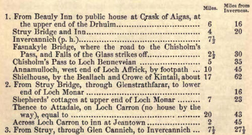
1. GLENSTRATHFARAR, BRANCHING
OFF FROM STRATHGLASS AT STRUY.
8. Of old, the whole district
from Inverness to this point was known under the name of Strathfarar; the
Firth of Beauly was called by the Romans, latinising most probably the
native names, Æstuarius-Varrar, and the valley at present denominated
Glenstrathfarar, shows itself, by its designation, to be the narrowest part
of the great strath. Glenstrathfarar runs nearly due west along the base of
the mountain Benevachart, on the estate of Struy, for a distance of about
ten miles, and is confessedly one of the most picturesque valleys in the
Highlands. In geological phrase, it is formed of a succession of small
circular valleys, opening into one another, and in consequence it presents a
variety of landscape, generally bold and rocky, but beautifully wooded, and
interspersed with soft, low meadow grounds. At its further end the glen
terminates in the basin of Loch Miulie, in which is a small island whither
Lord Lovat retreated after the disaster at Culloden, and from the summit of
one of the adjacent mountains, encompassed by a few faithful adherents, he
beheld the flames of the conflagration which consumed his own and his
clansmen's houses.
Three miles beyond is Monar
House (Captain White), at the lower end of Loch Monar, and thus far the road
is adapted for carriages; but beyond, it is a mere tract, and the traveller
should, if possible, make his way to the head of the lake, which is seven
miles long, by boat. There he will find a shepherd's cot, at which, as it is
twenty-five miles distant from Struy, he should rest for the night. The
shores of Loch Monar are wild, but picturesque, and at the eastern end,
where the water is hemmed in by a narrow tortuous strait, the remnants of an
ancient pine-forest are seen, of which, farther on, stumps and fallen trees
only appear, though these are met with in the mosses all the way to Kintail.
According to the historical manuscript of a Highland clergyman of the
seventeenth century, a great hunt took place here in the year 1655. It is
thus described:-
"The law here is strict
against loyalists, so that the Earl of Seaforth entered his person prisoner
in the Sconce at Inverness, as also the Lord Macdonald, and had their
respective lodgings within the citadel. Seaforth procured a furlough this
year, putting himself under bail to Governor Miles Man, and went to visit
his friends the length of Kintail; and resolving to keep a hunting by the
way in the forest of Monar, he prevailed with the Master and Tutor of Lovat
to go along with him. The tutor pitched his tent on the north side of the
river, and Struy his tent upon the south. Next day we got sight of six or
seven hundred deer, and sport of hunting fitter for kings than country
gentlemen. The four days we tarried there, what is it that could cheer and
renovate men's spirits but was gone about? Jumping, archery, shooting,
throwing the bar, the stone, and all manner of manly exercises imaginable.
And for entertainment, our baggage was well furnished of beef, mutton,
fowls, fishes, fat venison—a very princely camp—and all manner of liquors.
The fifth day we convoyed Seaforth over the mountain in sight of Kintail,
and returned home with the Master of Lovat—a very pretty train of gallant
gentlemen. Masters Hill and 'Ian, two Englishmen who were in company,
declared that in all their travels they never had such brave divertisement;
and if they should relate it in England, it would be concluded mere rant,
and incredible!"
9. Scuir-na-Lapich, a
beautifully-peaked mountain belonging to Lord Lovat, lies on the south side
of Loch Monar, and between it and Glen Cannich; and to the west of it an
enormous shapeless mass, called Ryuchan, flat at top, and seared in front by
innumerable streams and gullies, the first and highest mountain on the
Lochalsh property, and from the summit of which both seas are visible. The
peaks of Crechil come next, and most splendid grassy shoulders descend from
them, stretching off and uniting with the rich pastures of the west coast.
It will take seven hours' hard walking to reach Attadale, on Loch Carron,
from Loch Monar, and that over the most rugged ground, but without any
considerable ascents, the path passing at no great distance from Lochs Ged,
Cruashi, and Calivie, and from one great pastoral valley to another by
gentle undulations, till, after crossing Luip-Y-Guilig, an open hollow,
where the hill paths from Monar, Strathconon, Loch Carron, and Loch Long
unite, it descends into the rocky and picturesque Strathan of Attadale,
where brushwood, cultivation, and the cottages of the MacRaas, a pure,
swarthy, dark-eyed, and tall Celtic race, greet the weary traveller. From
Loch Monar the scenery is rather wide and open, but the straths and hill
sides are beautifully green, and the forms and tints of many of the mountain
groups and single peaks are exceedingly interesting. In Glenstrathfarar, the
tourist can refresh himself at several farm-houses, and perhaps he might get
quarters for a night at one or other of the shooting-lodges there, but for
the last twenty miles there is no bothie at all to be seen.
2. GLEN CANNICH.
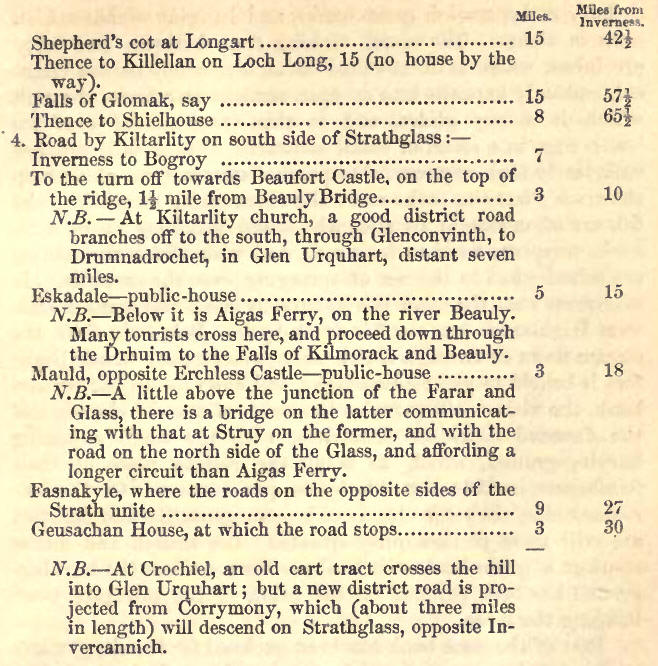
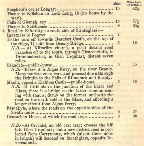
10. Glen Cannich, or the Glen
of the Cotton Grass, which abounds throughout its pastures, strikes off from
Strathglass at the clachan or village of Invercannich, seven and a half
miles above Struy, and after a short rocky ascent, it turns westward, and
stretches out for twenty miles before the eye, as a broad mossy valley,
abounding in most valuable pasture, but covered to a great extent by a
succession of uninteresting lakes or tarns, of which Loch Longard (called in
maps Loch Moyley, and which is six or seven miles in length) is the most
considerable. At the farther end of this lake, which is about half way
across, is a shepherd's cottage, where the traveller will be made welcome,
but no other is to be seen till he reaches Killellan, on Loch Long, about
fifteen miles distant. Glen Cannich is of a lower level than Strath Affrick,
to which it is nearly parallel, except that it trends more to the north, and
it is higher than Glenstrathfarar. Its west end is called Glasletter,
significant of its rich green pastures, and here the estates of the Chisholm
and Lochalsh meet. From the edges of the plain the mountain acclivities rise
up on all sides in long unbroken and beautiful slopes, clothed with the
richest herbage, and thousands of choice Cheviot sheep are reared upon them.
A good road could easily be made along this glen ; but the overflowings of
the lochs in winter would have to be guarded against, whilst higher up it
would be much exposed to deep snow wreaths, and the rough shores of Loch
Long, at the west end, could only he surmounted at a great expense. Instead
of going so far as Killellan, we would advise the traveller, soon after
passing Loch Edrum, where the waters first Shear towards the west coast, to
ford the Elcaig river, and, ascending to the south-west, visit the
Falls of Glomak, and thence proceed, as after described, to Shielhouse by
the Crowe of Kintail.
3. THE CHISHOLM'S PASS, AND
STRATH AFFRICK.
11. Between the bridges of
Invercannich and Fasnakyle, the tourist will find an excellent road striking
off to the right, which was made for the conveyance of wool from the
Chisholm's sheep farms in the interior, and which terminates at the nearer
end of Loch Benneveian, four or five miles distant. It ascends rapidly, and
then becomes level, and it commands fine views of the strath it has left,
and of the river above whose course it conducts, on which are a series of
beautiful cascades, from ten to thirty feet high, occurring in the course of
a rapid upwards of a mile long. The opening through which this road leads is
called THE CHISHOLM's PASS. The scenery is somewhat similar to the
celebrated birken bowers of Killiecrankie and the Trosachs, but on a much
ampler and grander scale; and to the beauty of the birch, and of many large
native ashes and elms, the intermixture of tall, fantastic pines, here
superadds the sober and imposing majesty of the Rothiemurchus and Mar
forests. In ascending the shelving opening, a prolonged vista in one general
mantle of foliage ascending high on either side, forms a woodland picture of
incomparable beauty, threaded by the rocky channel of the river. The path is
prolonged westward from the termination of the good road through the
Chisholm's Pass, and is daily becoming more passable for horses as well as
foot passengers.
12. After resting at the
shepherd's cot at Achagait, on a fine green haugh at the exit of the Glass
from its parent lake, the tourist must proceed by land, if not so fortunate
as to find the Loch Benneveian boat at the east end. This sheet of water is
five miles long, and about a mile broad in the centre, and wider at the
lower than the upper end. The surrounding mountains are high, bold, and
massive—quite bare on the north side, but the sloping declivities on the
south are closely and extensively covered with pine forest, of which a fine
circular screen also encloses the head of the lake. Beyond it the gigantic
mountain masses of Loch Affrick rise in most graceful majesty, and present
long, slightly-curving summits and lines subsiding very gently in the
distance, the broad and remote peaks of Kintail filling up the centre, the
whole composing an exquisite landscape of severe but most engaging grandeur.
The character of the scene is realized in Thomson's "Castle of Indolence."
"Full in the passage
of the Vale, above,
A sable, silent, solemn forest stood;
Where nought but shadowy forms were seen to move,
As Idless fancied in her dreaming mood:
And up the hills, on either side, a wood
Of blackening pines, aye waving to and fro,
Sent forth a sleepy horror through the blood;
And where the valley winded out, below,
The murmuring stream was heard, and scarcely heard, to flow."
13. A narrow rocky barrier,
covered with pine and birch separates Loch Benneveian from Loch Affrick; and
launched again upon the latter, the tourist will perceive every feature as
he advances more gigantic and imposing than those he has already explored.
The hoary pine forests still continue, but in more broken masses ; but with
groups and single trees now only crowning a zone of low eminences, which
line both shores. Loch Affrick terminates below in a lengthened stripe,
widening for a space in the centre, partially bordered with meadow ground,
and overhung by birch and pine trees, and thus affording the most admirable
foregrounds, comprising a most romantic shooting-lodge of the Chisholm's ;
while the distant vista retains the same finely outlined character. As we
advance, the mountains, which previously appeared in depressed perspective,
increasing in size, press close at hand, especially on the north, in all
their lofty majesty; and the pine-clad shores bestow an indescribable sense
of lonely and sombre solitude on the scenery. This lake is also about five
miles long, and a mile across where widest. The foot-path on the northern
shore glides along the beetling crags of Scour-na-Lapich and Mam Soul, and
at length ushers us on a fine meadow plain at the farther end of the loch,
where the shepherd's house at Culivie, neatly fitted up, will be heartily
welcomed by the traveller as his night's quarters.
The water of Affrick
separates this house from Annamulloch (a ford, where a set of reivers from
Mull are said by tradition to have been drowned) from another shepherd's
cottage, which is similarly fitted up, either for sportsmen or
travellers,—that is, having the "ben" room boxed round, with snug boarded-up
beds in the side, which are farther provided with the luxuries of English
blankets and sheets ; and the occupants, to their other civilities, will
obligingly assist in procuring the use of the boats on the lochs, especially
if a message is sent beforehand that they are wanted.
14. Should the tourist have
time, we would recommend his ascending Mam Soul before proceeding farther,
if the weather is fine, as the view is remarkably grand, both seas being
visible from the summit ; and, if a botanist, he will find on the upper
shoulders a most interesting intermixture of east and west coast plants
;—'while in some of the greater corries he is almost sure of being gratified
with a sight of a herd of red deer. The nearest approach in Britain to
perpetual glaciers, likewise occurs in the snow and icy patches on this
mountain; but the story is quite fabulous, that a green little lake on the
northern shoulder is frozen the whole year over.
15. An eight or nine hours'
walk from Culivie, or Annamulloch, will land our pilgrim at Shielhouse, in
Kintail—the foot-path being quite distinct the whole way, keeping on the
north side of the Aifrick Water, along an open level valley, at the further
end of which a sudden cleft in the terminating range of rocky hills, called
the Beallach (literally the Pass), lets us "drop down," with cautious
footsteps, to the Crowe of Kintail. A single bothie at Aultbae, at which a
bowl of milk may be had, is to be met with in the hill, about four miles
west from Loch Affrick, where an opening in the mountains leading southwards
conducts to Cluany, in Glen Moriston. At the head of Strath Affrick, a glen,
or hollow, running at nearly right angles to the north, and containing three
small lochs, brings us, at about four miles' distance, to the Falls of
Glomak, on the river of that name, from which a different route from that by
the Beallach conducts to Shielhouse. For a description of those remarkable
falls, the highest in the Highlands, and the approaches to them, and of the
scenery generally in this day's route, we refer our readers to Route i.,
Branch F. page 198.
Throughout this last day's
walk, the whole country has been treeless; but the green pastures redeem the
loss by their brilliant lively hue, very different from the brown sombre
colour of the east-coast moors. A few alders and birches reappear in Kintail,
as we attain the level of Loch Duich, but they seem dwindled down to mere
twigs; and an impression of solemn admiration and awe steals over the mind,
as the stupendous peaks and frontlets of Kintail first burst on the view. |