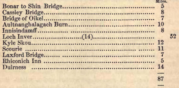
|
Sutherlandshire Roads, 1.—Strath
Oikel; Rosehall; Cassley River aria Waterfall; Castle-na-Coir, 2.—Burial
Ground; Clan Conflict at Tutumtarvach; Bridge of Oikel; Cascades; Oikel
Bridge to Ullapool; Glen Enic; Loch Damph; Achall, foot-note, 3.—Luhcroy;
Conical Mountains; Leeches; Loch Boarlan; Boundary of Ross and Sutherland;
Ledheg Marble Quarries, 4.—Glen of Assyut; Loch Awe; Clearness of Water in
Assynt; Stronchrubie; Limestone Rock, 5.—General features of the country,
6.—Loch Assynt; Ardvrock Castle; Defeat and Capture of Montrose, 7.—Achumore
Spring; Bull Trout; Cunaig, 8.—Loch Assynt; River Inver, 9.—Loch Inver;
Sulbheiu (Sulvein), 10.—Western Coast of utherland; Loch Inver to Store;
Olney and Kyle Skou, 11.—Loch Assyut to Kyle Skou; Storehouse; Herring
Fishery, 12.—Peculiarity in Walls of Round Tower; Glen Dhu and Glen Coul,
foot-note; Eddrachillis Parish; Small Lakes; Badcaul; Seourie, 13.—Handa,
14—Condition of the Peasantry; Reay Deer Forest; General Hugh Mackay,
16.—Loch Lanford and River; Inchard Loch and River; Achrisgill River; The
Gualin; Bay of Duirness, 16.
1. FROM Bonar Bridge, a road
proceeds, in a north-west direction, to Loch Inver, in Assynt, which leads
through Strath Oikel, the boundary between the shires of Ross and
Sutherland, and through the glen of Assynt, which is occupied for a space of
ten miles by the waters of Loch Assynt, besides which there are one or two
other small lakes on the way. From Loch Assynt, and about twelve miles from
Loch Inver, a road strikes northward to Kyle Skou, a narrow arm of the sea,
which is crossed by a ferry, from which the road is continued through the
peculiarly rugged district of Eddrachillis to Scourie, on the west coast,
whence it conducts by the head of Lochs Lax-ford and Inchard, two other
salt-water lochs, to the Kyle of Duirness, an inlet indenting the north
coast, and here it joins the line of road from Tongue. The Eddrachillis road
has been but a few years finished; it completes the communication round
Sutherlandshire, and invites attention to an expanse of scenery singularly
wild and grand, and to districts comparatively untrodden by the foot of the
stranger. As already mentioned, too, one can be conveyed from Golspie, on
the southeast of the county, to the west coast at Loch Inver (and also to
Scourie), or the north at Tongue, in ten or twelve hours by the
mail-gig—(see page 401). Having traversed the distance between these points,
he can, by the like conveyance, regain the east coast in the course of a few
days, or, finding his way between Scourie and Tongue on foot, or by the
conveyances, such as spring or dog carts, to be had, one at least of either,
at each stage, make the whole circuit.
2. Having crossed Shin
Bridge, five miles from Bonar, the road towards Assynt runs due west,
through the beautiful valley, anciently part of the district known by the
name of Ferrinbusklyne, and thereafter of Sleischillis, and which was gifted
by the Earls of Sutherland, in the twelfth century, to the Bishop of
Caithness. The united waters of the Cassley and Oikel (which effect a
junction eight miles up the valley), swelled with many a tributary mountain
torrent, become here a fine large river, and form the well-marked boundary
between the counties of Sutherland and Ross. The valley on the Ross side is
beautified by several clumps of natural copsewood, whilst, on the Sutherland
side, the townships of Inveran, Linsidemore, and Linsidebeg, display a
number of snug-looking stone cottages, picturesquely situated on rocky
eminences, and commanding a view of the extensive meadows that skirt the
river on either side. Three miles above Shin Bridge, the road winds at the
foot of the craggy barrier that bounds the valley on the right, having a low
wooded swamp on the left ; and this character is retained for some miles,
until we reach the enclosures of Rosehall. To this point the tide flows,
being a distance from Bonar of twelve miles. The road here recedes from the
banks of the river, and, ascending the rising ground on the right, crosses a
very handsome bridge over a deep rocky deli, of the most picturesque
character. The property of Rosehall, now belonging to Mr. James Matheson,
used to be distinguished by the extent of its plantations, chiefly of firs,
and by the lofty protecting walls with which the late Lord Ashburton
invested them. Great part of the wood has been cut down; still there are
extensive plantations and woods to the fore. Since Mr. Matheson became
proprietor, the condition of the crofters and small tenants on this property
has been much improved, and now rendered self-supporting. At this place has
been discovered a vein of manganese, in the state of black oxide. [The wilds
of Sutherland contain many rare species of insects, some of them not
elsewhere found in Britain; and some uncommon species of fish, denizens
chiefly of the fresh-water lakes. Three miles east of Bosehall, and close by
the road-side, Dr. Greville found the very rare plant Ribes petreum.]
A short distance beyond the
avenue leading to Rosehall House, and after passing a missionary chapel on
the right, we reach the river Cassley—provided we pass unhurt the very steep
descent of this part of the road. This river is an excellent angling stream;
and, nearly a mile above the bridge, we come to a remarkable waterfall,
forming a salmon leap, such as that upon the Shin already described, but of
greater altitude, and consequently of more difficult and rare achievement.
From the Bridge of Cassley the road sweeps again to the southward, towards
the river Oikel (which here unites with the Cassley), affording a fine view
of the front elevation of Rosehall House, encircled with its luxuriant
plantations-
"A stately progeny of pines,
With all their floating foliage richly robed."
From this point, too, are
seen the old walls of Castle-na-Coir, situated on a low flat meadow on the
Sutherland side of the Oikel. The road then again takes a westerly direction
up the valley, keeping chiefly along and close to the banks of the river.
The lofty hill on the right is clothed with full-grown firs to its summit,
and contributes, with the natural birch and alder trees that stud the low
ground, to give a pleasing woodland character to the otherwise marked
Highland features of the strath. The river, too, with the many graceful
windings formed in its rapid course, adds its own share of beauty to the
scene, being seen to much advantage from the elevated bank along which the
road passes for some miles. Continued fine level meadow ground, of
considerable extent, lines the firth and river for several miles above, as
below Invercastle. The hills are somewhat higher than at Invershin ; the
strath wide and open.
3. Three miles from Cassley
Bridge, and opposite to the township of Brae, on the Ross side of the river,
we reach Tutumtarvach, with its headlong burn; a little to the east of
which, there is a sequestered unenclosed burial-ground, picturesquely
situated on an elevated bank—a verdant sunny spot —but withal sad and
melancholy; its lonely site, its gray flat stones, the humble chronicles of
this hamlet of the dead, and its nameless graves, roofed with the green sod,
all combine in increasing the natural solemnising influence of such a scene.
After leaving it, the road ascends abruptly a reach of broad heathy heights
occupying the middle of the valley, where a desperate and bloody conflict
was fought, about the beginning of the fifteenth century, between a party of
Macleods from the island of Lewis (who had made a foray on the mainland, and
driven off a number of cattle) and a body of Sutherland men; and from the
heavy slaughter on this occasion, the place is said to have derived its name
of Tutumtarvach, significant of the natives of the district having had great
advantage from it. In this conflict a touching incident occurred similar to
that in the Fair Maid of Perth, where is recorded the devoted sacrifice by
the brave old Torquil, in the noted contest on the North Inch, of his
various sons to save his foster-son Hector. Seven brothers on this occasion
fell beneath the sword of a redoubted champion of the invading force. But
here it was the voice of a mother that shouted once and again—"Another to
stand against Kenneth!" Attaining the top of the rising ground, the former
features and scenery of the valley undergo a change; the hills appear more
barren and rugged; deep glens are seen opening inland at a distance; and the
country is now all clad in brown heath, intermixed with deers'-hair moss (Pleocliaris
coespitosa), relieved only by occasional clumps of stunted birch, and a few
green meadows along the course of the river, which character it retains
until we reach the Bridge of Oikel (distant seven miles from Cassley),
without anything worthy of notice, if we except the remarkably rocky
water-course of the stream of Baderguiny, which is crossed by a high
single-arched bridge, about half-way between Tutum and Oikel. A new inn has
been built at Oikel Bridge, but not on the Duke's property, nor in
Sutherlandshire, and not at all equal to the Sutherlandshire inns, but it
has good stabling. Some hundred yards above the inn is a linn or waterfall,
presenting a continued series of cataracts tumbling over a particularly
rugged channel, which terminate in one greater and very formidable-looking
fall.
"Moor'd in the rifted rocks,"
that form the precipitous
banks of the river at this point, are several full-sized fir-trees, having
their roots fixed, or rather twisted, in the most singular manner in the
crevices, and where no soil whatever can be discovered. On the brink of the
north bank of this river, just over the fall, is a small turf-cot. During
the salmon-fishing season it is tenanted by a short athletic Highlander, who
sits all day long at the door, with his feet hanging over the bank, watching
the fall most intently. The traveller may do so likewise, and see the fish
leap over. This is no sooner accomplished, than the Highlander has his
bag-net in the "pot," immediately above the fall, and he almost invariably
succeeds in bringing out the fish.
Beyond this spot the tourist
should, in the hot season, make use of his thin veil, with which he ought to
be provided, to protect himself from the attacks of the myriads of
mosquitoes, or midges, which infest the central and western coasts of
Sutherland more than any other county in Britain. Accustomed as the natives
are to their annoying bites, their patience is often sorely tried by them;
and to strangers the pain inflicted by these little creatures is at first
quite excruciating.
[A rough district road
conducts from Oikel Bridge to Ullapool on Loch Broom, a distance of
twenty-one miles, through a very beautiful tract of country. It first passes
through Glen Enic, a wide shelving glen, rising at once from the rocky
channel of the river in swelling slopes, wooded with small birch, and which
undulate away to the higher acclivities. The hills are of elongated outline,
and covered with fine pasture and short heath, and the glen forms a fine
piece of scenery, wide, wooded, and secluded. As we advance, some of the
singularly outlined mountain groups of the west coast attract admiring
notice. About four miles from Oikel Bridge, the glen forks into
two—southerly and westerly. The way to Ullapool lies along the westerly
opening. The distance, for half a dozen of miles from the inn, may be
shortened by keeping the north instead of the south side of Glen I;nic,
along which latter the road is carved. Loch 1)amph, about half-way to
Ullapool, is a pecuharly and softy beautiful and pleasing sheet of pellucid,
green-margined water, about three miles long, and half a mile broad, lined
by unbroken hills of nearly level outline, about 1000 feet high; likewise
carpeted with a rich heathy pasture, the lower half of those on the south
side well covered with masses of birch. The water flows in opposite
directions from the ends of Loch Damph. Ascending from the shores, we soon
attain the summit level, and then descend somewhat rapidly the shelving
valley, through which the Achall river first holds its way, and cannot fail
to be struck with the beauty of the glen, as it comes suddenly in view—the
clear alder-studded stream, seen beyond the wooded declivities which stretch
down on either hand, winding away before us through fine meadow land, and
the plain beyond between the circling heights, occupied by birch woods. On
the meadow ground below, the Marquis of Stafford, now proprietor in right of
the Marchioness, has a shooting-lodge, his deer forest extending from the
east end of Loch Damph for some miles below the lodge. On the north side
here, a long mural frontlet of dark-gray limestone, about 300 feet high,
crowning the acclivity, gives a peculiar character to the scenery. Loch
Achall, a singularly sweet piece of water, next attracts our admiration. It
is about three miles below the lodge, is about two and a half miles in
length, and swells out to rather better than a mile in width, and succeeds a
fine meadow dotted with alders. Continuous green hills, with gray protruding
rocky spaces interspersed, and of elongated outline, skirt the water. At the
lower end, successive circling and somewhat raggedly outlined heights
subside and converge almost to the water Tine; but beyond a long unequally
tabular mountain, with very abrupt terminations, one of the
strongly-featured range, on the west side of Loch Broom, hems in the
landscape. A wooded promontory projects from one side into the lake. Under
sonic aspects, especially as we have seen it of a summer evening, a scene
more sweet cannot be looked upon than Loch Achall. About three miles
further, above the deep channel which the river has worked through the
bright emerald-tinted limestone rocks, we descend to the considerable
village of UIlapool, beautifully situated on an alluvial promontory about
half a mile square, at the base of high abrupt hills, which closely flank
the lengthened waters of Loch Broom. Mr. ]Matheson, now superior of Ullapool,
has formed two miles of new road towards Oikel, and we trust the 'Marquis of
Stafford will complete the line of communication. We believe the obstacle to
he apprehension of disturbing the deer, on which point, the effect of a
road-way, instead of~a number of hill-tracks, there is a difference of
opinion. The inn at Ullapool has partaken of the improvements in progress on
the roads.]
4. Leaving Oikel Bridge, the
traveller shortly afterwards passes through a small township, where some
huts, and a few patches of arable land, help to diversify the monotonous
appearance of the heath-clad hills. Isere, if the weather be clear, the
first sight is obtained of the lofty mountain of Cannishb, in Assynt, which
may be distinguished by its singularly sharp conical shape. About two miles
from Oikel Bridge is the farmhouse of Lubcroy, pleasantly situated on a
green holm where the river Conchar flows into the Oikel; opposite to which,
on the Sutherland side, is a steep lofty hill, finely wooded to its summit.
From Lubcroy, the road proceeds with a gradual ascent along the side of a
wide-stretched hill for three miles, from which the valley on the right is
seen for a considerable way, hacked in the distance by the rugged tops of
Ben More of Assynt, the highest mountain in this part of the country, and in
the distance by the summit of Ben Liod in Duchily. On gaining the summit of
the rising ground, a stranger is particularly struck with the sudden and
singular appearance of several lofty conical-shaped mountains to the west,
which, perfectly detached from each other, start up from the elevated
table-land on which they rest, sheer and steep from their base-
"Catching the clouds of
heaven."
The largest and farthest
south of these strange-looking mountains is Coulmore in Coigach : the centre
one, with its forked head and hanging side, is Sulbhein, or "The Sugarloaf;"
and the most northern is Cannishb, already mentioned. When seen from the
slopes adjoining the Ross-shire hills, these mountains have a particularly
grand appearance, no less than seven conical peaks being, in some instances,
visible at the same time. Here we pass for several miles over a great
expanse of elevated moorland. [A little farther on, the road passes over a
bridge; and on the moor, to the left of the road, between these lochs and
the bridge, Cares uniflora occurs in great abundance.] The country merely
presents one uninteresting surface of deers'-hair moss and heathery pasture,
the uncommon appearance and shapes of the distant mountains being the only
interesting objects. Two small lochs, Craggy and Loch-na-helac, are found on
the moorland waste. The former is noted for its leeches, the latter as a
resort of the wild swan. Ten miles from Bridge of Oikel we reach a long
lake, with low and uninteresting banks, called Loch Boarlan, into which
flows the rivulet of Aultnaghalagach, the boundary between Ross and
Sutherland in this quarter: so that, arrived on the west side of this burn
we are again in the county of Sutherland, and in the parish of Assynt. The
name of Aultna ghalagach signifies "burn of deceivers," and arose from
witnesses, in determining the boundary between Assynt and Kincardine,
encroaching considerably on the Assynt side, and making oath they stood on
Ross-shire ground, having earth from Balnagown in their shoes! Out of Lake
Boarlan, to the west, runs a small river, along which the road passes,
having steep hills to the right, the sides of which are furrowed into many a
deep chasm by the winter torrents; and these, when flooded, are very
picturesque. The road, after passing the small farm-house of Ledmore on the
left, winds towards the north, and while it and the surface of the ground
appear to decline to that direction, the river of Ledbeg, on the left hand,
is seen flowing to the south, and, to a stranger, presents the anomalous
appearance of forcing its way against the ascent of the country. At Ledmore
a road branches off south-west to Cnockan, the extreme boundary of Assynt
towards Loch Broom, which has now been continued to Ullapool, sixteen miles
distant. Farther on, we pass the farm-house of Ledbeg on the left. Here are
inexhaustible quarries of beautiful marble, one perfectly white and pure as
alabaster, another of a variegated colour, veined gray, blue, and red, and
capable of receiving the finest polish. These were worked, some years ago,
by a Mr. Jopling from Newcastle; but, owing principally to the disadvantages
arising from the want of roads fit for the conveyance to the coast of the
weighty blocks, the speculation did not succeed; and, although this chief
obstacle has now been removed, no attempt has been made to renew the
undertaking.
5. After leaving Ledbeg, the
road, still going northward, proceeds along the sloping side of a wide and
great valley, called the Glen of Assynt, formed among large rounded
mountains; Cannishb, on the left hand, towering high above all others. The
tops of these mountains, from being thickly studded with white-bleached
stones and portions of protruding rock, appear as if covered with a
sprinkling of snow or boar-frost, and thus create a chill feeling even in
the hottest period of summer. About three miles farther down this valley, in
which Loch Awe, a long narrow lake, with several small islets, ornamented
with natural wood, is the only object to diversify the scene, we come in
sight of the upper or east end of Loch Assynt; and, still farther on, arrive
at the farm of Stronchrubie. The road is often intersected with watercourses
and small rivulets, that tumble noisily down the steep sides of the hills,
forming many small cataracts. The water is of the purest quality, cold as
ice in the hottest weather, and beautifully clear, displaying its pebbly or
marble bed, blanched by its action into Parian whiteness. The greater part
of these streams, many of which are of sufficient body to turn the largest
mill wheel, proceed from a single spring; the springs of Assynt being
proverbial for their extraordinary size, and the delightful quality of the
water. After leaving the farmhouse of Stronchrubie, the road passes into the
lowest part of the valley; and on the right hand a splendid range of the
limestone rock presents itself to view, and nearly facing the east end of
Loch Assynt. It is here composed entirely of blue limestone, with only
occasional thin strata of foreign matters: its height is about three hundred
feet, rising in successive steps, the top part forming a perpendicular cliff
of great beauty, close and thick ivy being seen ornamenting its front in
several places, with here and there a bush of the broad-leaved or Wych elm (Ulmus
montana), and a stunted stick of the white beam tree (PJrus aria). About a
hundred feet above the base issue three springs of excellent water. Below
the precipice, it may be mentioned, the Dryas octopetala covers large
patches of the hill slope. The road proceeds along the foot of this range
for upwards of a mile, when we arrive at the inn of Innisindamff, distant
eight miles from Aultnaghalagach. Here also are the parish church of Assynt,
a small lonely building, and the manse, beautifully situated on a moderately
rising ground, and commanding one of the finest views in this part of the
country. The highest limb of Ben More is seen towering in great majesty
through a craggy glen to the east, and surrounded on all sides by very
imposing mountains: to the west is the beautiful expanse of Loch Assynt,
having the singular mountain of Cunaig on the north; and the solid mass
called Bengarrow, with the summit of Camisve, or Camisbhe, rising high above
on the south.
6. The whole district of
country through which we have conducted the reader from Lairg, is one vast
succession of sheep walks, unbroken by almost a single human habitation.
Several of the Sutherlandshire tenants farm to the extent of 20,000 to
30,000 sheep. The general surface of the hill ground, leaving out of account
the more lofty mountains, is smooth—covered for the most part with a deep
stratum of peat, clothed with heath and moss—the low grounds, however, and
occasional spaces on the hill face, bearing a luxuriant vegetation—that is,
of pasture, for of tree or shrub there is hardly a specimen till we reach
Loch Inver, where there is some extent of young plantation. The inclination
of the lower hills is gentle, and their sides far reaching, and the glens or
straths wide spreading. There are few individually picturesque features. It
is the prevailing sense of almost utter solitude, and of pathless space,
impressing itself on, and colouring the thoughts, that forms the peculiar
characteristic of the central wilds of Sutherlandshire.
There is a good inn at
Innisindamff at the head of Loch Assynt.
7. The road passes along the
north shore of Loch Assynt, which at every turn presents some new feature in
the landscape. The lake, like most of the Sutherlandshire lochs, abounds in
fine trout; and no obstruction is offered in most of them to the angler; but
now several of the river fishings are rented by the innkeepers and others,
who charge pretty high for the privilege of salmon fishing. About a mile and
a half from the inn, is the shell of a large double or twin house, built by
the Mackenzies, Lairds of Assynt, about the beginning of last century. This
place is called Eddrachalda. Some hundred yards farther on are seen the
ruins of Ardvrock Castle, beautifully situated on a peninsula jutting out
into the lake. It is supposed to have been built prior to the sixteenth
century, and was long the residence, the "bannered place," of the Macleods,
who possessed Assynt before the Mackenzies, until the latter obtained a
footing in the district, at the close of the seventeenth century, after
several intrigues and attempts to storm the castle. This castle was three
storeys high (the lowest being vaulted), with one circular tower, and is
noted as having been the place of confinement of the celebrated Marquis of
Montrose, when taken prisoner by the Laird of Assynt, in 1650. It was also
the scene of " many a wassail wild, and deed of blood," commemorated by song
and story; but now -
"No more its arches echo to
the noise
Of joy and festive mirth. No more the glance
Of blazing taper through its windows beams,
And quivers on the undulating wave.
But naked stand the melancholy walls,
Lash'd by the wintry tempests, cold and bleak,
That whistle mournful through the empty halls,
And piecemeal crumble down the towers to dust."
It was in great part
destroyed, in 1793, by lightning. Montrose, in prosecution of his
adventurous enterprise in behalf of Charles II., as calamitous as his
expedition for his father had been brilliant, had sent 1200 foreign troops
before him to the Orkneys, of whom no less than 1000 perished by shipwreck.
The remainder he joined with 500 more, to whom he succeeded in adding 800
Orcadians; and with his little army of 1500 men he landed in Caithness, near
John-o-Groat's. He had calculated on collecting a considerable force in this
county, but completely failed; succeeding, however, in securing the passes
of the Ord, leading into Sutherland, and possessing himself of the Castle of
Dunbeath. The Earl of Sutherland retired before him as he advanced, and
Montrose reached Strath Oikel, but with a force of only 1200 men. The Earl
was met at Tain by the Rosses and Munroes, and by Colonel Strachan, who had
hurried forward with a party of horse, while General Leslie was pressing on
with 3000 foot. It was resolved that the Earl should cross into Sutherland
to intercept Montrose's retreat to the north, while Strachan advanced with
230 horse and 170 foot in search of him. Under cover of some broom, they
succeeded in surprising him at disadvantage, on level ground, near Fearn, on
the 27th April 1650, having diverted his attention by the display of merely
a small body of horse. He immediately endeavoured, in vain, to reach a
rugged hill with his infantry; but they were overtaken, and almost to a man
slain or taken prisoners, their commander and a few gentlemen escaping on
horseback. They directed their flight up Strath Oikel, and, Montrose,
betaking himself to the disguise of a peasant, and dismounting, in company
of an officer of the name of Sinclair, toiled his heartless and aimless way
on foot through these wilds, for nearly a couple of days and nights, and was
reduced to such extremity as to be fain to eat his very gloves. The Laird of
Assynt, being apprised that the fugitive was suspected of having bent his
steps in the direction of his country, and a reward being held out for his
capture, had a search made, and soon succeeded in having him securely lodged
in his castle of Assynt, though, before this reverse of fortune, he had been
on the eve of joining his standard. Local tradition says that the recompense
which the laird obtained for this exploit was the mighty one of forty bolls
of oatmeal!
8. At this place a noisy
stream tumbles down the rocky side of the hill into the lake, and issues
from a single spring at Achumore, which is seen on the high ground. This
spring constantly discharges a current of four cubic feet of the purest
water. Still proceeding downward, we pass close to the southern rugged base
of the mountain Cunaig, and here the limestone of the upper part of the lake
terminates, and to the west shapeless masses of gneiss predominate. In Loch
Assynt, and in some of the small lochs which discharge their waters into it,
bull trout (Salmo Hucho) [We have been since informed that the trout here
caught are not the real Bull trout, but Salmo Briar, or "Grey." The larger
specimens have large, really fierce-looking heads, with formidable rows of
sharp teeth. They are sometimes met with as large as twenty pounds. The head
is disproportionately large. Inuzula arcuata is found on Ben More of Assynt,
being one of only three stations where it occurs in Britain. The other two
habitats arc Poinnebhein in Duirness, and the summit of the mountains at the
source of the Dee.] of the finest flavour, and of a large size, are caught.
A small rivulet, which, about a mile from Innisindamff, joins another
running into the loch from the east, a quarter of a mile before joining the
main stream in the glen, disappears, flowing into a cave in the limestone;
but it can be traced by its rumbling noise for some hundred yards, until it
appears again on the surface, a little before it joins the larger burn. In
the course of its subterranean journey, the roof of its tunnel has fallen in
in two or three places, where the water is visible. In one of these openings
grows the beautiful dolopendrium vulgare, and in the neighbourhood (on the
east shoulder of Cunaig) we also find the delicate Scottish filmy fern,
Hymenophyllum W lsonii. A road here strikes off to the north, being the
commencement of the important line of road to the Kyle Skou of Assynt, and
thence, through Eddrachillis, to the North Sea. The road to Loch Inver still
follows the north shore of the loch, near the end of which is passed a
picturesque little loch on the right, close to Loch Assynt; and at this
point the steep and lengthened west side of Cunaig appears strikingly to
view, its summit singularly broken and serrated, and spiring into all the
forms of alpine wildness.
9. Loch Assynt is a
remarkably fine sheet of water. It is distinguished by a considerable
diversity of character between the upper and lower portions, the former
being lined by lofty and rugged mountains, and terminated, at the head, by
the noble limestone frontlet of Strone Chrubie; while, at the other end, the
bounding hills decline in height—rough and rocky, but here and there
partially wooded with dwarf birch. Numerous short rocky points project from
the shore, and the loch is further marked by a bend towards the lower end,
at right angles to the main body. The road keeps close alongside the water,
and immediately ushers us into the midst of a maze of rocky gneiss hillocks,
through which the river Inver threads its way, of varying breadth of
channel, the road following its banks; and, after a course of from four to
five miles, it discharges its waters at the bead of Loch Inver, a
land-locked inlet of the Atlantic, encircled by the like description of
rugged gneiss hills.
10. The village of Loch Inver
consists of only a few scattered houses and cottages, but it possesses the
advantage of having one of the best inns in the county. Mr. Dunbar, the
landlord, is well known as a zealous naturalist, sportsman, and angler. his
collection of stuffed animals, particularly birds, is indeed most valuable
and interesting, more especially as containing specimens of all the
different varieties of eagles, hawks, owls, and other birds of prey found in
Sutherlandshire. The eagle is to be found in greater abundance in Sutherland
than elsewhere. Some keepers have killed as many as forty in a season.
Eagle's eggs fetch as high as fifteen shillings a-piece. A boat-car is kept
at Loch Inver for loch-fishing, and a dogcart is also to be had at the inn.
Loch Inver is pleasantly situated at the head of the loch, at the foot of a
zone of craggy hills, and during the herring-fishing season it is the resort
of a great number of those adventurers, from all parts, who obtain their
bread upon "the waters." There is likewise a good salmon-fishery here. A
pier of some size has been built by Donald Macdonald, Esq., sometime of
Culaig, who erected houses sufficient to cure 800 barrels of herrings at a
time, and who also used to carry on here extensively the preparation of
preserved meat, fish, and vegetables ; but this establishment is now
discontinued, and the buildings have been converted into a residence for the
Duke of Sutherland when he may visit this part of his estates.
The extent and majesty of the
mountain screens about Loch Inver, the conical detached forms of some of the
hills, and the boundless reach from the adjoining heights, of "the dark and
deep blue ocean," streaked only in one or two directions by the dim chains
of Skye and the Long Island, bestow on this village a most peculiar
interest. Even Dr. Macculloch himself seemed at a loss how to describe the
scene. Yet, in his own most graphic style, he has thus sketched some of its
bolder features "Round about there arc four mountains, which seem as if they
had tumbled down from the clouds; having nothing to do with the country or
each other, either in shape, materials, position, or character, and which
look very much as if they were wondering how they got there. Which of them
all is the most rocky and useless, is probably known to the sheep ; human
organs distinguish little but stone ; black precipices, when the storm and
rain are drifting by, and, when the sun shines, cold bright summits that
seem to rival the snow. Suil Veinn loses no part of its strangely
incongruous character on a near approach. It remains as lofty, as
independent, and as much like a sugarloaf, (really, not metaphorically,)
when at its foot, as when far off at sea. In one respect it gains ; or
rather the spectator does, by a more intimate acquaintance. It might have
been covered with grass to the imagination ; but the eye sees, and the hand
feels, that it is rock, above, below, and round about. The narrow front,
that which possesses the conical outline, has the air of a precipice,
although not rigidly so; since it consists of a series of rocky cliffs piled
in terraced succession above each other ; the grassy surfaces of which,
being invisible from beneath, the whole seems one rude and broken cliff,
rising suddenly and abruptly, from the irregular tableland below, to the
height of 1000 feet. The effect of a mountain thus seen is always striking;
because, towering aloft into the sky, it fills the eye and the imagination.
Here it is doubly impressive, from the wide and open range around, in the
midst of which this gigantic mass stands alone and unrivalled ; a solitary
and enormous beacon, rising to the cloud' from the far-extended ocean-like
waste of rocks and rudeness. The conical appearance of Suil Veinn vanishes
on a side view. Thus seen, it displays a prolonged ridge with an irregular
summit, but the sides all around are precipitous, like the western extremity
; and at the east end, it terminates in a similar manner, looking wide over
an open rocky country, and thus preserving its independence in every part.
The lateral outline is varied and graceful ; the whole mountain in every
direction, presenting an object no less picturesque than it is uncommon and
striking in effect: combining, in some positions, with the distant and
elegant forms of Canasp, Coul Beg, and Ben More (3230 feet high), it also
offers more variety than would be expected ; while even the general
landscape is varied by the multiplicity of rocks and small lakes with which
the whole country is interspersed. The total altitude from the sea-line is
probably about 2500 feet ; the table-land whence this and most other of the
mountains of this coast rise, appearing to have an extreme elevation of 1500
feet. To almost all but the shepherds, Suil Veinn is inaccessible: one of
our sailors, well used to climbing, reached the summit with difficulty, and
had much more in descending. Sheep scramble about it in search of the grass
that grows in the intervals of the rocks ; but so perilous is this trade to
them, that this mountain, with its pasture, which, notwithstanding its rocky
aspect, is considerable, is a negative possession, causing a deduction of
fifteen or twenty pounds a-year from the value of the farm to which it
belongs, instead of adding to its rent."
To aid the reader's ideas, we
must observe that these mountain-tops are some miles inland, and that
between them and the spectator extends that agglomeration of gneiss
eminences which we have mentioned. Suil Veinn is quite unique among the
mountains of Scotland ; the cone rises quite by itself, nearly 2000 feet, we
should say, instead of 1000, according to the foregoing extract, above the
rugged table-land of gneiss hills, which may rise about 800 or 1000 feet
above the sea-level. One of the best points of view is about a mile from the
inn, on a road leading up from the loch, a little south of the inn. Here a
limb of the mountain, on the east, shews as a wart-like excrescence on the
acclivity. But the tourist ought not to omit to take boat out for a mile or
more. Thence a whole series of huge mountain masses, of the most varied
shape and outline, are seen at different points rising from the rugged
table-land, as Cunaig, Ben More of Assynt (in the distance), Canishp, and
Suil Veinn (forming the central points), Coul More, Coul Beg, Stack Pollie,
Ben Ione, Ben More of Coigach (in the distance), all ranging about 3000 to
3500 feet, or more, above the sea. From the water, Suil Veinn looks first
like a huge glass-house, and as one gets out more from the land, it assumes
more of the "sugar-loaf" aspect. The tourist will also be repaid by a walk
of five miles along the road leading from Loch-Inver House to the Fall of
Kirkaig, on the river of that name—a stream of considerable volume, the
boundary, on this side, between Ross and Sutherland shires.
FROM ASSYNT TO DUIRNESS.
11. Instead of retracing his
steps, and crossing from near Innisindamff, by the east shoulder of Cunaig,
to Kyle Skou, on his way further north, the traveller may vary the route by
proceeding to Stoir and Oldney, fourteen miles from Loch Inver, to which a
branch road has been made, and there taking boat for the Kyle. The road
winds at first rapidly up and down, and among gneiss hillocks deeply
divided, and containing in their bowl-shaped hollows several small tarns
covered with water-lilies, and from the elevations commanding views of Suil
Veinn and Canishp to their very base. The former here presents two distinct
summits, the lowest reaching about three-fourths of the height of the
principal mass, with which it connects by a narrow ligature—the whole,
perhaps, having as much the appearance of a helmet as any other object which
can be instanced. About six miles from Loch Inver we reach the township of
Stoir, a group of fishermen's huts upon a spot of sandy downs. Ascending the
further hill face, we pass the Church and manse, and shortly after the Free
Church and manse of Stoir. Here the whole summits, Canishp, Suil Veinn, Coul
More, and Coul Beg, with numerous successive ranges, come under the eye—the
Corgach and Loch Broom mountains, with those of Skye beyond, while the Lewis
is seen stretching seaward. Some three miles further, another considerable
collection of huts, called Clachanessy, occupies the head of a sheltered
bay.
The distance from Oldney to
the entrance of the inlet to Kyle Skou may be six or seven miles. The hills
of Edderachillis are spread out before us, rising stage behind stage of
gneiss ranges, on which the naked rock, and the scanty heath and pasture are
pretty nearly equally intermixed, forming one continuous rocky band—the only
marked deviation from the mean elevation being, as seen from hence, the
tabular summit of Stack, on the south side of Loch Shin. Near hand, Cunaig,
lying between Loch Assynt and Kyle Skou, presents itself in various
aspects—the central point of the panorama, which, from the point of Stoir,
on the south, to the perpendicular cliffs of Handa, on the north, a circuit
of upwards of twenty miles of coast—shews only one at a time of the
half-dozen of isolated houses, all, with the exception of the little
township of Clachanessy, to be found along its iron-bound shores; so
scattered, even on the coast, are the scanty population of this vast county.
The inlet to the Kyle, and to Loch Dhu and Loch Coul beyond, is as grand a
sea loch as can be imagined. There are two or three successive compartments,
the largest about a mile and a-half wide, completely land-locked by barriers
of low rocky hills, behind which are upreared the lofty bare hills which
environ the two branches of Glen Dhu and Glen Coul, into which the inlet
forks; while, on the right hand, Cunaig presents two enormous mountain
masses at right angles to each other, one of which descends from the summit
in a segment of precipices of the most imposing grandeur.
12. Until the year 1831,
there was no proper road, excepting that from Golspic, to Loch Inver, just
described, through any part of this very rugged district; and the traveller
desirous of proceeding northwards, had only the alternative of threading his
dubious and weary way over rocks and bogs, under the pilotage of a guide, or
of hiring a boat and coasting it along the singularly torn rocky shores that
gird the district of country between the great Promontory of Stoir and Cape
Wrath. These shores are covered with jagged and stupendous rocks, with huge
promontories projecting into the sea, stoutly braving the fury of the waves.
The lofty and impending cliffs are the home of the eagle and numberless
aquatic birds; while the deep caverns below are the habitations only of the
seal and the otter. Previous to the formation of the road, a foot-runner
penetrated to the north with the letters once in six weeks ! He served as a
walking chronicle, putting up for the night at set houses, whither the
people gathered on his arrival to learn the news.
Now, however, an excellent
road (though very narrow, like most of the roads in Sutherlandshire,
excepting the Great North Road, being only eight feet wide, with an edging
of sward of a foot broad on each side) to the northward has been formed,
through the parish of Eddrachillis, to the North Sea, at the church of
Duirness, which completes the communication round the coasts of the county
of Sutherland. It strikes off from the Loch Inver road, near the base of the
mountain Cunaig, at Loch Assynt, and about three miles from Innisiridamff.
Proceeding across the high ground between this lake and the Kyle Skou, this
line of road is, in consequence, somewhat steep in several parts, although
by no means so much so as the elevated appearance of the country on all
hands would lead a stranger to expect. The aspect of the scenery along its
course is that of utter wildness, joined to the most uninterrupted solitude
and seclusion. From the length of the ascent from Loch Assynt, the
interminable ranges of hills become somewhat monotonous; but at the top a
magical change of scene occurs, as the magnificent expanse of the Atlantic,
with numerous islands, presents itself, and a deep, but narrow, arm of the
ocean, and in several compartments connected by very confined straits,
penetrates among the mountains, while Cunaig, on the left, uprears above a
tremendous craggy front. Nine miles from Loch Assynt we arrive at the
township of Unapool, and at the narrow, and very rapid, but well-regulated
ferry across the Kyle Skou to Kyle Strome, in the parish of Eddrachillis.
The small public-house is on the south side. A spring-cart is kept here. The
Kyle at this point is seen dividing into two branches, near its termination
at the east ; one branch passing into Glen Dhu, the Dark Glen, and the other
into Glen Coul—two of the wildest and most romantic glens in this part of
the Highlands, the hills rising on all hands to a great height, interspersed
with formidable cliffs, and the water of great depth. [Should the tourist
wish to penetrate to the extremities of the lochs of Glen Dhu and Glen Coul,
We recommend him to procure a boat from the ferry, as the footing by land is
undecided, easily lost, and not easily found. The scenery up Glen Coul is
wild and savage in the extreme. It consists of three compartments, up the
two lowest of which the salt-water flows. Between these is a very narrow
strait, flanked by lofty rocks, and the land communication is along a ledge
on the face of one of these, exceedingly narrow and dangerous. The water
below is of great depth, and a false step were certain destruction. Glen
Coul is, in wet weather, distinguished by one very high fall—that of Egg
Coul Awlan, the beautiful back-lying waterfall—in the course of a burn which
comes down the face of a rock about 700 feet in height.] At the Kyle the
scenery alternates at every turn from soft to wild and romantic. The north
front of Cunaig is also here beheld rising in great majesty, and in two huge
masses, faced from summit to base, sheeted, and deeply furrowed precipices.
From Kyle Skou a road is proposed to be formed in a southerly direction
along the coast to Oldney, from which a road is already made to Stoir and
Loch Inver. The north side of the ferry consists of a small peninsula, which
at first sight is mistaken for an island, on which there is a tall
prison-like storehouse, said to have been erected upwards of 200 years ago.
The Kyle at this place is one of the best frequented fishing-stations in
this quarter, in consequence of the safety of the anchorage, and the almost
incredible shoals of fish that may be said to fill up this little
channel—their young being found in abundance in it in winter, as well as
early in summer. So many as 100 herring-busses have resorted to it at once;
and the value of the herrings killed here in 1829 was estimated at £30,000.
The take of herrings was also very large in 1849. The communication now
opened by land along the coast will, it is hoped, encourage the
establishment of a chain of regular fishing-stations from Loch Inver
northwards to Wick; by which means the capitalist, following the migratory
course pursued by the fish, will be enabled to turn both this rich marine
treasury and his own resources to the best advantage. Meantime, however, we
regret to say, that the two there were at Loch Inver and Rispond have been
discontinued, and thus the people have no means of getting the fish cured
and disposed of in any quantity.
Before quitting the Kyle, we
must not omit to notice an unusual appearance, and, as far as we are aware,
peculiar to itself, excepting a similar occurrence in the south of Arran, in
the walls of the ruins of a round dune or tower on a little tongue of rock
near the Kyle, which is isolated at high-water. These uncemented walls
remaining are about eight feet high, and at the top about four feet thick.
In the middle of the thickness of the wall, for about two feet, and
extending all round, the stones are mingled with bones, which are decidedly
human, but rather under the usual size. Their occurrence and preservation,
supposing, as we needs must, the building to be of any considerable
antiquity, are alike unaccountable, though the salt of the sea air and spray
may be conceived to have had some influence.
13. Having crossed the Kyle
Skou, we enter the parish of Eddrachillis, which is justly reputed the
wildest and most rugged district in Scotland. The whole face of the district
of Eddrachillis, as far as Rheconich, is composed of ranges and knolls of
gneiss, only partially covered with vegetation, but still valuable to the
sheep farmer from the sheltered nature of the ground. The hollows are more
roomy, the masses of hilly rock larger, and the appearance less intricate
than about Loch Inver. After leaving the ferry, the road proceeds with a
long but not very steep ascent, until, rounding the shoulder of the hill, it
declines gently along the high side of a deep valley. For a considerable
distance the road winds up and down in many a tortuous flexure through
narrow defiles, the view being limited by the surrounding masses of rock and
hill; but several small tams and lochs, occasionally of some size, each,
completely girdled round with rocky eminences, and frequently adorned with
beautiful aquatic plants, appear at almost every bend of the road. The
number of these lakes here, as in Assynt, especially in the north-west
division, is incredible ; and, being distinguished either by dark, still
water, indicative of great depth, at the foot of rugged rocks, or by green
sedgy banks and shallow margins, beautifully ornamented with the stately
bulrush, and the elegant flowers and handsome leaves of the white water
lily, (NJmpluea alba), are very pleasing features amid the singular scenery
of the district. [In a marsh on the right of the road, about half-way
between Kyle Strome and Badcaul, the prickly twig rush, Cladium
nfariscus,grows. Until its discovery here, (1833,) it was said to be extinct
in Scotland since the draining of the moss of Restenet, near Forfar.] The
road is generally pretty much elevated, but here and there it descends to
the coast. From the top of the mountains, many of which attain an elevation
of 3000 feet, the country, intersected by arms of the sea, and chequered
with lakes, rivers, and ravines, presents a peculiar aspect. Viewed from
some miles' distance at sea, the landboard is considered to bear a close
resemblance to the Norwegian coast.
A few miles further on, the
road passes through a small wild glen, along a noisy stream that foams down
its rocky bed into the sea at the safe harbour of Loch Colva. The projecting
and angular ledges of rock that form the south side of this glen are very
striking, and form a marked and beautiful variety in the scenery.
Beyond this glen, the scenery
retains a similar character until we reach the sheltered bay of Badcaul;
improved, however, at a few points, by occasional vistas of the ocean. Bad-caul,
where the manse and parish church are situated, and a large establishment
for the preserving of the salmon caught all along the coast, is distant nine
miles from the ferry at Kyle Strome. Here a great many small islands attract
attention from their number and grouping. About three miles farther on,
through the same description of country, we reach the inn (now a very good
though small one, and at which a phaeton is kept) and township of Scourie,
surrounded on all sides, except the west, by an amphitheatre of rugged
ledges of rock, backed by the pyramidal summit of Stack, and having in front
a bay, wide at the opening, but receding at its upper extremity behind
sheltering rocks. This place is comparatively verdant and arable, though the
arable ground is of small extent; but then in Eddrachillis there is no such
thing as ground capable of cultivation, except on the most confined scale,
and it derives additional attractions from the contrast it presents to the
sterile and rocky surface that encompasses it.
14. Nearly opposite to
Scourie, and at no great distance, is the large, but of late, uninhabited
island of Handa. This island forms the most wonderful object along this
coast, from its towering and majestic cliffs, and the immense number of wild
sea-fowl that inhabit every crevice of its rocks.
No tourist ought to omit a
visit to Handa. The island is formed of red sandstone, on which a highly
comminuted and beautifully grained conglomerate overlies. The strata dip on
the landward side, and the seaward front, is a range of precipices perfectly
perpendicular, and for most as smooth and mural as the most perfect masonry,
and washed by the ocean depths. They form a line of about two miles, ranging
from perhaps 600 to fully 700 feet. This is so stupendous as to be almost
unequalled in the British islands. Happily for the view hunter, they are
admirably disposed for being seen to the best possible advantage from the
summit, though in fine weather, when they can be approached by boat, new
and, in some respects, most striking effects may be obtained from beneath.
But they are widely indented, so that from opposing ends the eye commands
the various sections, and as the ground slopes upwards to the very verge,
the spectator can approach them without apprehension. In one of these
indentations two detached columns rise, at the distance of a stone throw,
and near each other—one about a fourth of the height, the other of the full
height of the adjoining cliff. A fissure in the rock exhibits the sides of
the larger one, which is perforated underneath—its upright lines seemingly
at a few yards' distance from the perfectly perpendicular parted lines of
the contiguous cliff. At another, the highest spot of all, a mural face of
prodigious length demands undivided admiration of its truly majestic
dimensions. Again, an enormous perforation reaches down to the level of the
ocean, which makes its flux and reflux by two natural arches, on either side
of a huge supporting block, underneath the seaward wall of the perpendicular
aperture. The tour of inspection ought to be commenced on the north side, as
the precipice attains the greatest elevation towards the opposite extremity
of the range. On the narrow horizontal ledges of the cliffs and detached
columns, and on the top of the larger one, are ranged and grouped, at the
breeding season, myriads of beautiful black-backed guillemots, and other
sea-fowl, as close as they can sit, while thousands are flying swiftly
about. A shot fired sets inconceivable numbers of birds on the wing. But the
pertinacity with which others stick to their roosting-places is quite as
extraordinary; stones, and even repeated shots among them, fail to displace
them.
A gun will be found a
desirable accessory. It is a common thing for the adventurous fowlers, who
hesitate not to descend, with the utmost unconcern, crevices where it can
hardly be credited that man would venture, to take the birds with the hand.
They are frequently, too, let down by a rope from above, when they capture
their prey by a noose fastened to a short stick. In this manner a man will
at times make free with eighteen or twenty score at a time. The eggs, too,
large, richly-tinted, and spotted, are an object of spoliation. These
chiefly lie singly on the naked rock. The nestling season is from the middle
of May till the middle of July, at which time a -visit has the additional
attraction of the seafowl, which at other times do not congregate here in
any great number. Banda is covered with a fine sward, but it is unsuited for
raising any sort of grain; and the few families who tenanted it, not long
ago, voluntarily abandoned it. It is now pastured by a few sheep, and a
flock of patriarchal-looking pure white goats. Some years ago a vessel went
to pieces on the terrific western precipices, when three or four of the
seamen succeeded in reaching, from the yards, a crevice in the face of the
cliffs. Here they were detected, after a lapse of some days, and rescued
with life still flickering in them, attention being directed to them by
parts of the wreck floating round the island. What a situation of hopeless
suspense and of protracted peril, and suffering from hunger, cold, and the
raging deep, and what a miraculous preservation from the very jaws of death!
The cliff scenery is not alone what distinguishes Handa. It stands so high,
and far enough from the land, to command a most comprehensive view of the
coast from Rustoir past Loch Inchard, and of the huge mountain masses which,
throughout this wide circuit, uprear their gigantic and varied forms, each
apart from the other, above the encircling zone of rocky hills, which form,
as it were, a common base to the whole—beginning at Ben Calva and Ben
Spionnadh in Duirness, succeeded by Foinnebhein, Arkle, Stack, Ben More of
Assynt, Cunaig, Cannisp, Suilvein, Coulinore, Coulbeg, Stackpollie, and the
other Coigach and Loch Broom mountains, and various other more remote
summits, with Skye and the Lewis. Such a magnificent mountain panorama can
hardly be surpassed, for the mountains here are all giants. These, it may be
remarked, generally range towards the east and west, so that in progressing
from north to south, they assume an infinite variety of appearance. The sea
to landward, all around, is diversified by long projecting rugged headlands,
and lines of rocky islands, while to the west extends the boundless surface
of the Atlantic, one glorious expanse of ctrrulnean hue, patched with
shifting masses of brown, produced simply by the shade of the varying sky.
The most striking-looking mountain from this quarter is Stack, the terminal
aspect of which is that of an enormous pyramid, rising to a perfect point.
Suilvein appears under quite a new character, the two summits being far
removed, and it shows itself to be in reality a long mountain, instead of
the terminal sugar-loaf figure from which it is so well known. On the way to
Handa a detached pillar of rock, at the point of Rustoir, from 200 to 300
feet high—broader above than below—shows, in the distance, exactly like a
large ship under studding sails.
15. The holdings of the poor
tenants on the west coast of Sutherlandshire average from £2 to £5 of rent.
The crop of a £3 croft, of which the stocking consists of three small
Highland cows, eight sheep, and one horse, will, in a favourable season,
with milk and fish, support a family of four for eight months. An almost
neglected mine of wealth lies at the door, in the cod and ling fishery,
which hitherto have been but little attended to. However, the deep-sea
fishing is said to be precarious on the coast; but abundance of the finest
lobsters are sent to the London market. A lobster smack calls every ten
days, and on the north coast every week, during three months, from the
middle of April to the middle of July, carrying away each time from 2000 to
5000 lobsters. The disinclination to round Cape Wrath makes a difference of
one-third (3d. and 4d. a-piece) on the price at Scourie and Duirness. Salmon
vessels call twice a-week for the fish of the whole coast northwards from
Skye, collected and packed chiefly at Badcaul. They are caught in bag-nets
off the headlands, net-fishing on the rivers on this coast being
discontinued. The destruction by the bag-nets is so great, as to have a
palpable effect in diminishing the numbers of the fish. Substantial cottages
of stone and lime have pretty generally been substituted for the comfortless
Ilighland hut, under the auspices of the noble proprietors.
About 60,000 acres of the
parishes of Eddrachillis and Duirness are allotted exclusively to the red
deer; of which animal, the Foinnebhein and Reay Forests—amongst the
principal in Scotland--support some thousands, under the charge of several
foresters. The numbers in Reay and Foinnebhein are computed at about 5000.
The deer of Sutherlandshire (and they are numerous in other parts of the
country) are considered to surpass any in Scotland, averaging fifteen stone
Dutch in weight, and at times exceeding eighteen stone. Those of the Reay
country have long been distinguished by a peculiarity of forked tails.
The family of "Mackay of Scourie" gave birth to Lieutenant-general Hugh
Mackay, commander-in-chief at the Revolution, and Dundee's unsuccessful
opponent at Killiecrankie, but a brave and able military, and otherwise
excellent character.
16. From Scourie the road
leads along the south side of Baddyndarroch; then, winding through several
rocky passes, and over a considerable tract of deep moss, and by a
shepherd's house at Baddynabay, the wayfarer arrives at an arm of the
salt-water loch of Laxford, which is of very irregular outline, with many
projecting points of rocky eminences, and at the considerable river Laxford,
which is crossed by a large substantial bridge seven miles distant from
Scourie. In this neighbourhood, some of the large mountains to the
east—particularly the huge pyramidal Stack, Arkle, also detached and
tapering, and the ponderous-looking and extensive Foinnebhein (pronounced
Founiven)—form very grand and picturesque objects. The Laxford is esteemed
among the best angling rivers in the north, both for salmon and trout, and
used to be of great resort to the angler; but it is now rented by Lord
Grosvenor—still free, however, we believe, for trout-fishing. The word
Laxford is a good example of the Scandinavian derivation of a great many of
the names of abiding features of the country—Laxfiord, the salmon-firth.
Stac and Merkland are also Scandinavian words, descriptive of the form of
the mountain and situation of the lake. Of the Scandinavian Dune or Burgh
there are traces of a great number along the west and north coast, although
Dune Dornadilla is the only one generally known. The names of places and
townships are Celtic. In many instances, a Celtic prefix is found where the
Scandinavian word is entire—thus, Helmsdale is now Strath-Helmsdale.
After leaving Laxford, the
road is formed along the face of an extensive and formidable rock, now
called Lawson's Rock, from the engineer who lined out the road, so situated
and overhanging the water as to have required great labour and expense in
its formation. Hence the road still proceeds through narrow anal lonely
openings, formed by nature amidst the innumerable masses of rock—which from
their ruggedness have proeureti this piece of country the appropriate name
of the Kerrngarbh—as far as Rhiconich Inn, at the head of Loch Inchard,
another extensive salt-water loch, distant six miles from the Bridge of
Laxford. There is also another large bridge here over the river Inchard, the
country beyond which appears more open. Intricate rocky hills, however, are
still for a little further the principal features of the scenery; on the
summits of which numerous large detached blocks of stone, resulting from
disintegration, are seen marking the outlines of the ridges. The pasture of
this rugged district is composed of deers'-hair-moss and coarse grass, with
little or no heather; and, in fact, it may be stated generally of the
pastures of Sutherland, that great tracts of them, especially in the lower
valleys, are more adapted for the rearing of cattle than of sheep, the
latter preferring to browse on the tender grasses of the uplands, where they
are also in the summer season less annoyed by insects than in the plains.
Indeed, the meadow-grasses are becoming so strong, from want of being
pastured, as to choke up the waters and increase the extent of marshy
ground. The shores of Loch Inchard are pretty numerously inhabited; and near
the mouth of the loch stand the new Government Church and manse, and also
the Free Church and manse of Kinloch-Bervie, to which a branch road strikes
off from Rhiconich. At Rhiconich there is a better sort of public-house,
where two or three beds can be had, should tourists have occasion to remain;
but they will generally push on for Durin or Scourie. [A spring-cart,
carrying three, is kept by the inn-keeper at Rhiconich, said a vehicle of
the sarne description at Kyle Skou,]
After leaving Rhiconich, the
road passes northward, and for a considerable distance proceeds along and
overhangs the river of Achrisgill, which is sometimes seen forming pleasing
cascades over the high rocks that cross its channel. But the sides and
bottom of the little strath through which it flows, are covered with heath
and pasture, and we now find ourselves in quite a different character of
country, the surface uniformly covered, except in the mountain masses, with
peat, heath, and pasture. The road still ascending—but very gradually for
some miles—reaches the shoulder of a lofty hill, proverbial for its open
exposure, and the consequent severity with which the storm beats upon it.
This tract is called the Gualin, signifying "the shoulder;" and here, on its
most exposed part, a house has been erected, where a dram is sold, which,
like the caravansaries of the East, may serve to shelter the luckless
traveller who may chance to encounter tempestuous weather while passing
along. The Gualin looks down upon the bend of a widely-extended valley,
stretching down from between Foinnebhein and Ben Spionnadh, on the west side
of which it descends to the head of the Kyle of Duirness. At each end of the
Gualin House, and also of the Moin House, between the Kyle of Tongue and
Loch Hope, there is a large slab inserted, with a long inscription
commemorative of the completion, in 1831, of the great chain of
Sutherlandshire roads—an allowable expression of natural complacency in the
contemplation of the successful achievement of a very arduous and
highly-useful undertaking. About half-way to the Inn of Durin, which is ten
miles from the Gualin, we reach the Kyle, a fine wide land-locked inlet,
bordered by heathy granite hills on the west; but the mountains on the east
decline into an elevated table-land of limestone rocks, stretching across to
Loch Erriboll, and affording the most fertile, beautiful pasture, and fine
arable land, subdivided by high and substantial stone dykes. The road,
crossing the river Grudie, which discharges itself into the Bay of Duirness,
passes along the shores of the bay to the farm of Keoldale; immediately to
the north of which, and distant fourteen miles from Rhiconich, the wearied
tourist will gladly hail the green knolls and modest church, and to him the
more immediately interesting comforts of the excellent Inn of Duirness. |

