|
SECTION III.
ROUTE I.
FROM GLASGOW TO OBAN,
FORT-WILLIAM, AND INVERNESS.
Diversity of Routes, and
their Characteristics, 1.-By Crinan Canal.-The River Clyde, 2.-Dumbarton
Castle, 3.-The frith of Clyde, Greenock, 4.-Dunoon Castle, 5.-The Ayrshire
Coast; Battle of the Laws, G.-Toward Castle, 7.Rothesay, and Castle,
8.-Kyles of Bute, 9.-Argyle s Expedition in 1685, 10.-Loch Fyne; East Tarbct,
11.---Crinan Canal, 12.--Crinan to Oban, 13 -Whirl- poo1 of Corryvreckan,
14.-Isle of Kerrera, 15.-Oban; Dunolly Castle, 16.-District around Oban,
17.-Glasgow to Oban and to Fort-William, by Loch Lomond.-Preferable Route,
18.-Dumbarton, 19.-Vale of the Leven, 20.-Loch Lomond, 21.-Ben Lomond,
22.-Glen Fallocb, 23.-Battle of Clenfruin; The Clan Gregor, 24.-Robert
Bruce's encounter in Glen Dochart, 25.-St. Fillan's Pool, 26.-Tyndrum to
Dalmally, 27.-Loch Awe; Ben Cruachan, 28.-Kilchurn Castle, 29.-The Pass of
Awe, 30 -Bunawe, 31.-Loch Etive, 32.-Ardchattan Priory, 33.-Connel Ferry,
34.-Dunstaffnage Castle, 35.-Berigonium, 36.-Oban, 37-Glasgow to
Fort-William, by Loch Lammed.-Loch Tollic; The Black Mount, 38.-Glencoe,
39.-Massacre of Glencoe, 40.-Loch Leven; The Serpent River; The Falls of
Kinlochmore, 41.-Ballachulish, 42.-From Glasgow to Oban, by
Inverary.-Diftcrent Routes, 43.-By Loch Long-loch Long, 44.-Glencroe; Glen
Lochan ; and Glen Finlass, 46.-Loch Fyneyy Fyne; Dunedera Castle, 46.-Inver-
ary, 47.-LochFyneHerring ; Inverary Castle, 48.-To Inccrary, by the Gareloch,
Lochgoile, and Loch Eck.-The Gareloch, 49.-Carrick Castle; Lochgoile,
50.-Holy Loch, 51.-Loch Eck, 52.-Glen Aray, 53.-Loch Awe; Port Sonachan ;
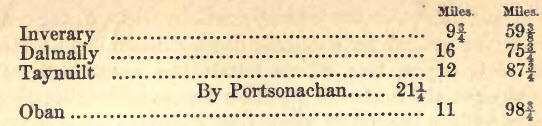
Glen Nant, 54.-Oban to Inverness. Loch Linnhe, 55.-Island of Lismore;
Auchindoan, 56.-Fort-William; biaryburgh, 57.-Ben Nevis, 58.-Lochaber;
Castle of Inverlochy, 59.-Battle at Inverlochy 60.-Bannavic, 61.-Monument at
Corpach, 62.--General Character of the Great Glen, 63.-Tor Castle, 84.-First
Skirmish in 1745, 65.-Loch Lochp ; Achnacarry, Sir Ewen Cameron of Lochicl,
66.-Battle of Cean, Loch Lochy, 67.-Laggan ; The Kennedics; The late
Glengarry, 68. -Loch Oich; Invergarry Castle, 69; The Well of the Heads,
70.-Loch Oich to FortAugustus, 71.-}'ort-Augustus, 72.-Loch
Ness,73.-Invermoriston, 74.-Falls of Foyers, 75.-Boleskine ; 'Inverfarikaig,
76.-Bona, or Bonessia; loch loch. four, 77; Dochfour to Inverness,
78.-Caledonian Canal-Adaptation of the Great Glen for a Canal, 79.-Survey
and Report by James Watt, 80.-Reasons for the formation of the Canal;
Telford and Jessop's survey, 81.-General description of the Canal, 82.-Cost
till 1827, when first opened, 83.-Imperfect state of the undertaking at this
period, 84.-Report by fir Walker in 1838, and nautical investigation by Sir
W. Edward Parry, 85-Completion of the Works by Messrs Jackson and Bean in
1843-7, 86.-Alditional outlay; Extent of accommodation for vessels and of
traffic now, 87.-Incorporation with the Crinan Canal, and Commission of
Management, 88.-Adaptation of Inverness and line of the Canal for
Manufactories, 89.-Prospective results to the Commerce of the Highlands,
90.-Southey's tribute to the memory of Telford, 91.-Roads along the Great
Glen, 92.-Fort-Augustus to Invermoriston ; Lower part of Glenmoriston,
93.Invermoriston to Drumnadrochet, 94.-Aultsigh Burn; Raid of Cillie-Christ,
95. Glen Urquhart; The Falls of Dhivach, 96.-Drumnadrochet to Inverness,
97.-Fort Augustus to Foyers; Vale of Killen, 98.-Stratherrick; The River
Foyers, 99.-The General's Hut, 100.-The Pass of Inverfarikaig,
101.-Inverfarikatg to bores, 102.-Doren to Inverness, 103.
1. THE circuit from the
metropolis of the west of Scotland to that of the Highlands, by the coasts
of Argyleshire and through the Great Glen, is the route most frequented by
the crowds of tourists attracted each succeeding season to the north of our
island. In this tour great variety of choice may be indulged, as one has the
power of making the whole journey by steamer, through the Kyles of Bute and
the Crinan Canal—of being transported by coach either to Oban or
Fort-William, with a water trip intervening on Loch Lomond. Or the traveller
may take Inverary on the way; to it again, selecting as it may be either of
the accesses by Loch Lomond, the Gareloch, Loch Long, Loch Goil, Loch Eck,
or Loch Fyne. As each and all of these lines of direction are replete with
the very finest features of mountain and water scenery, and converge upon
the western extremity of the Great Glen of Scotland, with its chain of
inland lakes connected by the Caledonian Canal, and uniting the Moray Firth
with Loch Linnhe, which respectively at either end prolong this grand valley
into the German and Atlantic Oceans, the attractions of this favourite route
can be readily understood. There is, indeed, certainly nothing within the
compass of the British islands at all to be compared with it in point of
extent of continuous grandeur, diversity, and beauty. The whole is
singularly magnificent, and far from palling by repetition, each new
peregrination will be found to add fresh zest to the enjoyment of the
incomparable scenery through which we are conducted. Now, too, the steamers
and other conveyances are of a much improved class, and large and commodious
inns have been erected at Ardrishaig, on the Crinan, and at Bannavie, on the
Caledonian Canals ; the access to this last being further improved by the
construction of a suspension bridge across the river Lochy, near
Fort-William. The whole distance is accomplished in from a day and a half to
two days —the intermediate night (by steamer) being spent at Bannavie on the
way north, and at Oban on the way south. Coaching between Glasgow and
Fort-William or Oban makes no difference in time, except on the journey
north by Oban, as the coaches do not arrive in time for the same day's
steamer. The Messrs. Burns of Glasgow, into whose hands the great bulk of
the traffic alongst the routes in question has passed—though after all but a
trifling branch of their very extended establishments —are laying themselves
out by a constant adaptation of the resources at their command, to the
increasing demands of the public, to afford accommodations in every
department of a superior order, and to provide ample facilities of
communication in every eligible direction, and at very moderate charges.
Of these different routes,
that
By the Crinan Caron,
as longer familiar to the
public, may with propriety take precedence.
2. This route is entirely a
marine excursion. There is no land journey. But the steamers' pathway is so
completely landlocked, that there are no high seas to be encountered, though
at times, in passing the Slate Islands, the swell from the Atlantic in fresh
weather may somewhat discompose unaccustomed constitutions.
We must leave to others the
description of the great emporium of the commerce, wealth, and enterprise of
Scotland. Wending our way then at once to the Broomielaw, we embark in one
of the well-appointed swift steamers which now daily during the
season—besides luggage boats all the year—convey their respective quota of
passengers to Inverness and the places intermediate. The channel of the
river Clyde being now deepened, so as to admit vessels of large draught up
to Glasgow, its wharves are found crowded with shipping and steamers of all
sizes and dimensions. Along the river banks are seen the hulls of immense
iron and other steam-vessels, in various stages of progress, the Clyde
shipbuilders and machinists having attained a high reputation; and the tall
receding chimney stalks giving out incessant volumes of murky smoke—that of
St. Rollox far pre-eminent, reaching as it does a height of more than 400
feet, continue to testify to that manufacturing industry, of which our
sojourn in the city had already furnished perhaps overabundant proofs.
Imposing lines of buildings extend in the back ground on the north, and
numerous villas bedeck the face of the country on the south bank. About a
couple of miles down the river the villages of Govan on the left, and of
Partick on the right hand, meet the eye. On either hand the country is low
but fertile; and as the boat passes along, some fine mansions, as Jordanhill
and Scotstown, Elderslie and Blythswood, claim attention. About six miles
down, the house tops of the ancient burgh of Renfrew are descried on the
left, and further inland the smoke of Paisley indicates its position. Some
miles on, passing the villages of Old and New Kilpatrick, the birthplace of
St. Patrick, we come to Port Dunglas, and the remains of its Roman fortress,
marking the western extremity of the old Roman wall or Graham's Dyke which
extended between the two firths, and to Bowling Bay, at the termination of
the Forth and Clyde Canal. Here a small obelisk commemorates the enterprise
and ingenuity of Mr. Henry Bell, who originated that steamer traffic to
which the Clyde owes so much of its opulence. On the southern shore, as we
near Dumbarton, Blantyre House (Lord Blantyre), a princely mansion, commands
admiration from its extent and elegance, and finely wooded parks. On the
north the Kilpatrick trap hills run in upon the water.
3. Dumbarton's isolated rock,
protruded to an elevation of upwards of 200 feet, at the confluence of the
Leven and Clyde on the north side of the latter river, with its bristling
batteries, forms a conspicuous object in a landscape of surpassing richness
and brilliancy. It is basaltic, and in many place columnar, and is split
into twin summits. The governor's house stands in a recess on the south
side, not much above the base of the rock : from it a steep ascent, by
flights of steps between a narrow gap, conducts to the confined space
between the two summits, at the further end of which are erected the armoury
and the barracks. The former contains 1500 stand of arms ; the latter can
accommodate about 150 men. Within the memory of man, the entrance was by a
footpath up the sloping hank formed of debris on the north side. In the
armoury is kept Wallace's great double-handed sword, an interesting memento
of the mighty dead. The guns of the fortress, sixteen in number, are
arranged about the governor's house, in the face of the highest rock, nearly
in the same line, and pointing down the firth, behind the barracks, and on
the top of the lower eminence. A very old fragment of masonry remains on the
latter, but coeval with what period tradition gives no note. In "Balclutha's
walls of Towers," mentioned by Ossian, we recognise Dumbarton's castellated
rock. It was the capital of the Strathclyde Britons. Alcluith is mentioned
by Bede as orbs munitissimac; and the possession of it being always regarded
as a matter of importance, it figures repeatedly in the stormy history of
our country. Still it was not one of the four principal fortresses given to
the English in 1174, in security of the ransom of William the Lion, and it
is believed to have been at that time only the principal residence of the
Earls of Lennox, the third of whom, Maldwin, surrendered it into the hands
of Alexander II. On one occasion it was the scene of a most adventurous
exploit. We allude to the perilous but successful escalade by Crawford of
Jordanhill, during Queen Mary's reign. While in the possession of her
partisans, this officer of the Regent Lennox, with a few followers, on the
2d May 1571, achieved the daring enterprise of scaling the dizzy precipice,
under cloud of night, surmounting in their progress an unexpected and a very
embarrassing difficulty. One of the party, in ascending a ladder, was seized
with a fit of epilepsy. As the profoundest silence was necessary, the most
imminent hazard arose of their being discovered by the man's falling, or the
noise unavoidable in attempting his removal. The expedient however was
promptly adopted, of making him fast to the ladder, which was then turned,
and his comrades were thus enabled to pass, and reach the summit unobserved.
A striking picture is
presented as we pass the mouth of the Leven, when the town behind the
castle, and its ship-building yards, and its glass-house cones, combine with
the castellated rock as a foreground to the fair and fertile vale of Leven,
bounded in the distance by the pyramidal summit of "the lofty Benlomond."
The panorama from the top of the castle rock is extensive, varied, and
beautiful, of the river and Firth of Clyde, the Leven, and the Highlands
girdling in various but unseen fresh and salt-water lochs. An eminence on
the elevated ground, intermediate between the Leven and the Gareloch, and
not far from Dumbarton, is interesting, as the site of the castle in which
Robert Bruce frequently resided, and in which he died.
4. We are now fairly on the
expanding bosom of the Firth, skirted by fertile sloping shores, diversifies
with intermingling woods. At Port Glasgow, now somewhat of a misnomer, as it
continues but partially to fulfil that relation, Newark Castle, a large
quadrangular pile by the sea, with numerous chimney stalks and hanging
turrets, momentarily recalls us from the busy present to the days of other
years. On the opposite coast the long extending houses of Helensburgh, one
of the favourite sea-bathing villages which abound on the Clyde, mark the
entrance to the Gareloch, concealed behind the wooded peninsula of Roseneath,
on which may be descried an elegant Italian villa, a seat of the Argyle
family.
Greenock, the birth place of
Watt, is an important and bustling sea-port. Its prolonged and many-peopled
quay, with its spacious and handsome custom-house, backed by docks filled
with shipping, is all alive with the hurry of arriving and departing
steamers.
The reach of the Firth to the
Cloch Light-house, where the coast line bends to the south, is one of
uncommon character. On the north its waters sweep backwards to the circling
hills, amongst which they indent themselves in the embracing arms of the
Holy Loch, Loch Goil, and Loch Long. Holy Loch is studded with an
uninterrupted zone of neat and ornamental and cheerful villas, forming and
connecting the villages of Duneon and Kilmun. On the south the villas
adjoining Greenock and Gourock equally betoken the eager concourse of the
teeming population of Glasgow for the enjoyment of the healthful influences
of salt water and the sea breeze. The shores around are lined with one
beauteous frame of cultivated and wooded slopes. The sterner features of
alpine scenery in the ranges of high and rugged mountains to the north,
contrast with the softer graces impressed by the hand of art on the low
grounds. Steam-boats glide along the water, while trading vessels, with, it
may be, a sprinkling of yachts and pleasure boats, with less undeviating
speed, are fain to woo the uncertain breeze. It is difficult to conceive,
without witnessing, the thoroughfare of steamers which the Clyde presents.
In the season the streets of Glasgow are almost literally deserted by the
fairer portion of the inhabitants, who flock to summer quarters on the
Clyde, some as far removed as Rothesay, Largs, Ardrossan, and Arran,
distances of forty to fifty miles and more, while their lords (of the
married portion) find their way down as often during the week as
circumstances permit; but on the Saturdays, or on Friday afternoons, they
literally crowd the steamers' decks, as fully bent on holiday relaxation as
when in schoolboy days they made weekly escape from restraint, returning to
their several avocations on the Monday morning. The privilege to the
population of such a ready and noble outlet is unspeakable, while the
consequent enrichment of the coast, with the enlivening movement of this
living tide, co-operate to heighten the attractions of this magnificent
estuary, which, taken all in all, is unrivalled in the three kingdoms. The
cabin fares are less than a penny, in some instances not exceeding a
halfpenny, a mile. All this life upon the water is, notwithstanding the
rivalry of a parallel line of railway from Glasgow to Greenock, another by
Paisley to Ardrossan, and now a third in progress on the north side of the
river, to connect the city with Loch Lomond.
5. On a green rocky knoll
projecting from the centre of the village of that name, are the foundation
walls of the ancient Castle of Dunoon, which seems to have been little more
than a single tower. It originally owned the hereditary High-stewards of
Scotland as its proprietors ; and it was bestowed on the Argyle family by
the crown in return for the important services rendered in aid of Robert the
Steward, in Edward II.'s reign, by Sir Colin Campbell of Lochow. Dunoon
Castle %vas taken by Edward Baliol, and retaken by Robert Stewart, grandson
of Robert Bruce, about the year 1334. It was a favourite place of resort of
that monarch for the enjoyment of the chase. On one of these occasions an
attempt to surprise him was made by Aymer de Valence, accompanied by 1500
horsemen ; but the Bruce having got intimation of the design, encountered
and defeated them in Glenderuel. Dunoon Castle was also taken in 1544 by the
Earl of Lennox, after a gallant resistance by the Earl of Argyle. It formed
the residence of the Argyle family till about the end of the seventeenth
century. Dunoon was also a Diocesan residence at one period. It is now one
of the most fashionable bathing-places on the Clyde.
6. The steamer's course now
keeps the northern or western shore, but the Ayrshire coast is sufficiently
near to enable us to appreciate the range of low beach, surmounted by
hanging woods, verdant pastures, and corn-fields. Various little enchanting
indentations as at Innerkip—where Ardgowan, the mansion of Sir .Michael Shaw
Stewart, peers forth from an affluence of foliage mantling the hill-sides ;
and Wemyss Bay, each present their clustering villas ; and marine residences
of manufacturing and commercial magnates continue to dot the shore line on
either hand. At the Bay of Largs there is a village of some
pretensions—another at Fairlie of smaller size, but almost wholly composed
of handsome residences, with enclosed garden-grounds of exuberant
vegetation, and those near the water's edge each provided with its
appurtenance of a boathouse. But these places are barely discernible. Largs
is remarkable as the scene of the great battle, or more correctly, of the
series of desperate skirmishes, in which Haco, King of Norway, was defeated,
with great slaughter, in 1263, and the power of Norway in the west of
Scotland irretrievably broken by the Scottish army under Alexander III. A
curious sarcophagus, quite entire, formed by huge and undressed slabs, on a
plateau immediately above the extremity of Largs, on the Fairlie road, would
seem to indicate the thick of the fray, or the spot where some great leader
fell.
In front of us, as we
advance, the Island of Bute to the north, with the small isles of the
Cumbrays, towards the Ayrshire coast, and between and beyond the highly
imposing elevation of the Island of Arran, Goatfell, and contiguous peaks,
conspicuous amongst its lofty and rugged summits, form a fine and varied
screen. In the remote distance we may detect the conical form of Ailsa
Craig.
7. On to the Point of Toward,
the extremity of the peninsula of Cowal, are a lighthouse and the ruins of
Castle Toward, the ancient stronghold of the Lamonts, and a splendid modern
mansion of the same name, the seat of Finlay, Esq.
Of the old castle, which
stood on a detached mound in front of a now wooded hill a little westward of
the Point, but a single tower remains. The offices of the modern building
are erected as for an outwork and gate of entrance to the castle, of which
the design is showy, but wanting in the massiveness and imposing effect of
the gloomy strongholds of the olden time. On passing the east coast of Bute,
Mount Stewart, the seat of the Marquis of Bute, comes into view. Should the
tourist's arrangements lead him to a sojourn on the island, he will be much
gratified by the great growth of the timber and extensive range of the woods
about this seat, and he will find here, too, a fine collection of paintings.
8. The Island of Bute is
nearly eighteen miles long by five broad. Rothesay, an ancient burgh, is a
favourite resort, in summer, of the inhabitants of Glasgow. Its
crescent-shaped and deeply imbedded bay is well protected by the encircling
hills. The population is about 4000 ; and, depending partly on letting
lodgings, the villas about are numerous, and varied in their style and
sizes, and much attention is paid to the cleanliness of the place, while its
fine and well-filled harbour lends it unusual animation and interest. The
fineness of the climate adds a fresh charm to the wayfarer in the luxuriant
shrubberies fronting the bay—fuchsias, in particular, attaining quite a
remarkable size; while its salubrity recommends it to the invalid for the
invigorating of the bodily frame. The principal inns are the Bute Arms and
the Clydesdale. This town, in addition to its healthy and romantic
situation, is rendered interesting by the ruins of its magnificent, old, and
ivy-cased castle, which is supposed to have been built in the eleventh
century, and was long a royal palace, and the scene of the death of Robert
III. Rothesay Castle was reduced by Iiaco, King of Norway, in his expedition
in 1263, and was subsequently held by Rudric, one of his officers, whose
daughter intermarried with the Stewards, its previous possessors. The
building is of considerable extent, there being connected with the palace a
spacious circular court, about 140 feet in diameter, formed by high and
thick ivy-cased walls; on the outside of which a terraced walk extends
around the castle, separated from the adjoining grounds by a wide and deep
ditch. This castle was partially injured by Cromwell's soldiers; and the
work of destruction was completed by a brother of the Earl of Argyle in
1685. Close by the castle is a large new jail and court-house. Several
graceful church spires serve to make up a most striking picture from the
water, especially where the towering ridges of Arran come into view in the
back ground. A green knoll on the west side of the bay, surmounted by the
ruins of an old chapel, commands a view of a low valley which stretches
across the island to Scalpsie Bay on the opposite side of the island, and
containing the waters of Loch Fad, but slightly elevated above high water
mark. This valley is finely cultivated, and intersected by large ash,
sycamore, and beech; and on a ridge, descending into it, stands the parish,
church, and the remains of a Roman Catholic chapel, in the walls of which,
under two canopied recesses, are full-sized e~gies in stone, which, with one
in the centre of the floor, are locally held to represent three brothers,
called "the stout Stewarts of Bute," companions in arms of Sir William
Wallace, and who fell at the battle of Falkirk. The shores of Loch Fad were
selected by Kean the tragedian as a place of residence.
9. The Kyles of Bute, in
their general character, are exceedingly pleasing, as they wind between
moderately-sized hills of undulating and unbroken outline, frequently
sinking sheer upon the water, and seeming to landlock the passage ; heathy
towards their summits, but verdant below, and there fringed with irregular,
waving lines of copse-wood and young plantations and stripes of cultivated
ground. Mingled agricultural and pastoral features, with successive
headlands and windings of the sea, are the characteristics which thus
distinguish the Kyles. Yet, from want of any marked features, perhaps the
general impression is rather one of disappointment. At the head of Loch
Strevan we perceive the terminating chains of the Highland mountains
disposed in several lofty rather detached rounded cones, verdant but devoid
of trees ; while towards Toward Point the softening ranges subside in wooded
and cultivated slopes. About two miles from Rothesay the steam-boat passes
the bay and village of Port Bannatyne on the Bute shore at the east end,
with Kaims Castle, an old castellated mansion, at the head of the bay.
Opposite Rothesay is the house of Achinwillan.
10. At the entrance of Loch
Ridden, on the right, and about the centre of the Kyles, on the islet of
Eilangreig, are seen the ruins of a castle which was garrisoned in 1685 by
the Earl of Argyle in his unsuccessful enterprise, and dismantled by some
English ships sent for the purpose.
Argyle, having opposed, and
afterwards refused to subscribe, a test which was devised by government
against the free principles cherished by the more determined friends of
Protestantism, had been tried and condemned as guilty of treason ; but he
contrived to effect his escape from Edinburgh Castle, and took refuge in
Holland. Here, with other disaffected refugees of distinction, he concerted
an expedition to Scotland, and sailed from Rotterdam with three ships and
about 300 men ; the Duke of Monmouth, at the same time, taking charge of a
similar small armament to make a descent on the coast of England. Partly
from want of due precaution in the Orkneys, intelligence of Argyle's
movements and force was furnished to government, so that adequate
preparations were made to oppose him. He however collected a small army of
2500 of his own and other clans ; but, remaining too long inactive in
Argyleshire, he was hemmed in by superior numbers ; and, his followers being
eventually obliged to disperse, he was taken prisoner at Inchinnan, near
Renfrew, carried to Edinburgh, and beheaded on the 26th June, 1685, meeting
death with distinguished fortitude. Monmouth, equally unfortunate, suffered
a like fate on Tower Hill. Argyle had deposited his stores, to the amount of
5000 stand of arms, and 300 barrels of gunpowder, in Eilangreig, under the
charge of a garrison of 150 men, who abandoned the castle, without offering
any resistance, to a royal squadron, which also captured Argyle's vessels,
and destroyed the fortifications.
11. Passing on the left the
dark mountains of Arran, from every point of view a striking group, from
their beetling precipices and strongly defined outlines, and rounding
Ardlamont Point, the steamer enters Loch Fyne. Skipness Castle, to be seen
on the coast of Cantyre, was one of the most capacious strongholds in the
Highlands ; being surrounded by a high and extensive wall, and the area
subdivided by a cross wall into two compartments, within one of which stands
the ancient square keep of four storeys, still inhabited ; having also two
other small projecting square towers. The shores of Cowal, on the right, are
low and uninteresting, and the hills without character; the Knapdale coast
pretty high, wild, and unattractive.
East Tarbert Bay, where a
narrow isthmus joins Knapdale with Cantyre, surrounded with exceedingly
bare, rough, rocky knolls, with the frowning ruins of its castle, is
uninviting, so that there is no room for regret that we are denied a close
inspection ; but the bay is a secure anchorage, and the village a
flourishing one, and contains an excellent inn. The ancient keep, of four
storeys, perched on a high rock, near the entrance on the southern shore,
with the hanging ruined outer wall, which encircled a very irregular area,
perhaps two acres in extent, and within which may have been a whole colony
of huts, besides the garrison, and larger buildings, are all that remain of
the old castle which was built by Robert the Bruce. Like Skipness on the
same coast of Cantyre, the tower has its staircase in the heart of the
strong thick wall, and has no corner turrets : the rooms were small, but
plastered ; and the outer screens had large round towers at intervals, two
in particular, between which was the main approach, but none entire. Ivy and
rank grass overtop the whole. A scheme was of late years projected for
uniting East and West Loch Tarbert by a canal, which would have been of
importance, particularly to the trade of Islay. For the, present it is in
abeyance.
12. Arrived near the thriving
village of Lochgilphead, a disembarkation takes place, the windings of the
Crinan Canal having to be threaded in a light track boat. The process, and
of re-embarkation again into another steam vessel at the further extremity,
occasions a rather disagreeable anxiety for the safe forwarding of one's
luggage, though the attendants are very careful in seeing after the
transmission of every package. Still, there might be some amendment in
regard to such small articles as may take injury, yet prove rather
cumbersome to carry one's self. The variety of conveyance is in itself a
pleasing change. This canal, intersecting the root of that long promontory
known by the name of Cantyre, is about nine miles in length. From the
dimensions of the locks, which in this short space are no fewer than fifteen
in number, each ninety-six feet in length, by twenty four in breadth, and
the sharp windings of the waterway, its utility in saving the doubling of
the Mull of Cantyre, which is both tedious and hazardous, is confined to
vessels of small burthen. Out out of banks of mica slate, which are
surmounted by brushwood and trees, and festooned with honeysuckle and other
plants, while an extensive moorland accompanies us on the right, the
navigation is highly pleasing and picturesque. This is especially so at the
outset, where the grounds of Achindarroch House or Oakfield (Campbell) lie
alongside, and on the other hand, Kilmorie Castle (Sir John Ord) embellishes
the view.
13. Arrived at the further
end, and on board the steamer in waiting there, as the detention at the
locks generally induces a good deal of walking, all parties find themselves
pretty well prepared to appreciate the well-ordered appointments of the
dinner-table. Quitting the Bay of Crinan, Duntroon—a modernized castle (
Malcolm), forms a conspicuous object. The run hence to Ardincaple Point,
south of Kerrera Sound, is an interesting part. of the, voyage. The numerous
detached objects, islands, mountains, headlands, bays, and inlets, broken up
into successive compartments, in their rapid transmutations, keep the
attention excited. The lofty conical mountains, hence called the Paps of
Jura, are objects too striking not to be alluded to. Off the point of
Craignish, near the Bay of Crinan, are several beautiful and picturesque
islands; and along the coast the trap dykes assume fantastic castellated
appearances. Loch Craignish, an arm of the sea, is distinguished by a chain
of islands in its centre, stretching longitudinally alongst it in a line
parallel with the shores, and composing, in their varied bold rocky, and, in
some places, cultivated and wooded spaces, with similar flanking coasts, a
landscape peculiar and striking, of which a glimpse is obtained.
14. Corryvreckan, the strait
between the northern extremity of Jura and the mountainous island of Scarba,
possesses a widespread notoriety. The commotion of the tides pouring through
this narrow passage is heightened by a large sunk rock. This dangerous
communication is studiously avoided by vessels and to small craft at certain
times it would prove sure destruction. The author of the old Statistical
Account of Jura gives us the following graphic picture of this whirlpool:
"The gulf is most awful with the flowing tide; in stormy weather with that
tide it exhibits an aspect in which a great deal of the terrible is blended.
Vast openings are formed, in which, one would think, the bottom might be
seen; immense bodies of water tumble headlong as over a precipice, then,
rebounding from the abyss, they dash together with inconceivable
impetuosity, and rise foaming to a prodigious height above the surface. The
noise of their conflict is heard throughout the surrounding islands."
"On the shores of Argyleshire,"
says Campbell the poet, "I have oftened listened to the sound of this
vortex, at the distance of many leagues. When the weather is calm, and the
adjacent sea scarcely heard on these picturesque shores, its sound, which is
like the sound of innumerable chariots, creates --a magnificent and fine
effect." Mariners never choose to tempt the rangers of this gulf. Vessels of
burthen, however, can make the passage; and at particular times it is
tranquil enough for boats to venture.'
15. Nearing Loch Feochan, the
steamer's course lies through intricate groupes of islands, Luing, Seil,
Shuna, Lunga, Easdale, and many others, on which there are excellent slate
quarries. These, with the workmen's houses, and vessels shipping cargo, are
an animated scene. They are near the shore, and the steamer runs between and
across the opening of Loch Melford.
The dark mountainous Island
of Mull, with its iron-bound shores, and the hills of Morven, famed in song,
are now seen to close in the seaward view. But in entering on that long
stretch of inland sea called Loch Linnhe, the attention is diverted to the
eastern coast, by the intervention of the long Island of Kerrera,
distinguished by the ruins at its southern termination of the Danish Fort
Gylen. To the geologist this island is of peculiar interest, as exhibiting
singular junctions of primary, secondary, and trap rocks, and a curious
angular conglomerate or breccia. The circumstance of its being the spot
where King Alexander II. died on his memorable expedition in 1249, and the
place of rendezvous where IIaco of Norway a few years afterwards met his
island chieftains, who, crowding with their galleys to assist hiin in his
descent on the coasts of Scotland, augmented his fleet to 160 sail, will
ever command for Kerrera the attention of the antiquary.
16. Kerrera forms a natural
breakwater to the Bay of Oban, stretching right across, and rendering it a
peculiarly secure ha N en. The bay is not capacious, but is flanked by
nearly parallel wooded rocks, and hemmed in by a higher rocky frontlet, at
the base of which stretch the houses of the village—a long line of neat
buildings, chiefly of two storeys, slated and white-washed, fronting the
water, and presenting a very cheerful and pleasing appearance. On a high,
isolated rock, forming the northern promontory of the bay, girt by
perpendicular precipices, and accessible only on one side, stands Dunolly
Castle, an ivy-clad square keep, an ancient seat of the Macdougals of Lorn,
descendants of the mighty Somerled of the Isles. It is four storeys high ;
but, with the exception of the vaulted dungeon, which is still entire, the
building is now a mere shell. Portions are standing of a wall which,
springing from two opposite angles, ran along the brink of the rock,
enclosing an irregular court. Conspicuous on the face of the rising ground
behind the village, a tasteful Free Church, of light early English
architecture, with a low Norman Tower and pointed spire, after a design by
Mr. Pugin has been lately erected. Nearly opposite the quay a larger and
loftier elevation indicates the Caledonian Hotel, a very commodious and
well-conducted establishment. There are two or three other inns of less
pretensions, and a large proportion of the inhabitants lay themselves out
for the accommodation of lodgers. Oban being a place of great resort in the
season, it is the centre of steam communication on the west coast. One is
hardly prepared, in so remote a corner, to find on some days of the week as
many at times as nine or ten steamers arriving and departing daily. There is
a daily steamer, and, on certain days, as many as three steamers to Glasgow.
One every day, and two on alternate days, to Fort-William and Inverness. One
thrice a week—indeed almost daily—to Staffa and Iona, and round the Island
of Mull, and two every week to Skye, and one to Stornoway. There are besides
two daily coaches, one from Glasgow by Loch Lomond, the other from Inverary.
It is also a favourite sea-bathing quarter and place of summer residence.
Indeed, in the months of July and August, it literally swarms with
strangers. Yet, for sea-bathing it is not well adapted. The water is all
that could be desired, and the beach is pretty good, but the ground along
shore is so confined, that there is little privacy, and there are no bathing
machines. This is, indeed, a general want on the west coast. On the Clyde,
however, the houses often lining the roadway along the bathing ground,
persons can dress and undress in-doors, though it is anything but seemly in
the fair sex in their bathing gear to cross the public way so unconcernedly
as they do. But, indeed, the good people of Oban are singularly behind hand
in meeting the requirements which one would suppose to be indispensable to
the suitable lodgment of their migratory visitors, if not to their own
comfort. The ground-storey of the houses being chiefly occupied with
shops—some of them very good—a peculiar mode of access to the upper floor
prevails, viz., by a passage right through the dwelling, and then up an
outside back stone stair-ease. Thus, and from close contiguity, the back
areas are disagreeably overlooked—in one part of the town the exposure is
heightened by the back-ground being to the water side. Many of the houses
are disgracefully deficient in some of the arrangements essential to the
decencies of life, and preservation of health. A drawback to the well-being
of the place is the limited supply of fresh water, which would probably call
for considerable expense to remedy by artificial contrivances. ' Some more
unexceptionable houses are springing up at the north end of the village. The
furniture is very commonplace, and the apartments plain enough. But the
charges are high. There is no regular butcher or vegetable market; the
supplies are uncertain, and mostly of inferior quality, even the mutton
being ill-fed and scraggy ; and, what will seem more strange, there is but
little fish to be had. A. good deal of salmon and salmon-trout at times, but
only so, and herring; but there is no white fish caught in the bay—what is
exposed for sale, and that in but moderate quantity, being brought chiefly
from Loch Etive. It is rather surprising, considering the steam
communication, that abundant supplies of all eatables should not flow in
from other places for general consumpt. The inns, of course, have their own
source of supply. No mean compensation is abundant and capital dairy
produce, excellent bread, and good groceries. There are some most
respectable shops—among others, a bookseller's, with a tolerable library.
Will it be believed that at this time of day there is no direct post between
Oban and Fort-William—a distance of only forty miles—and that a letter from
the one to the other has to be conveyed round by Inverary, Glasgow, Perth,
and Inverness, and the answer, of course, to make the same extraordinary
roundabout?
17. Yet with these drawbacks
a few weeks can be spent delightfully at Oban. The scenery around is in the
highest degree grand, varied, and beautiful; indeed, the whole features of
the district are remarkable, and it comprises many most noted localities,
while antiquarian remains of great interest abound in the neighbourhood. We
need but enumerate Staffa, Iona, the Sound of Mull, Loch Etive, Loch Creran,
the Pass of Awe, Loch Leven, and Glencoe, Ben Nevis, Ben Cruachan,
Dunstaffnage, and Dunolly, Duart, Ardtornish, Aros, Mingarry, Loch Alline,
Inverlochy, Kilchurn, Gylen, and other castles; Achendown, the Bishop of
Lismore's Palace, and Ardchattan Priory; Berigonium, the site, at least
reputed, of that Pictish capital ; memorials, some of actual monarchy,
others of the almost regal sway of those great princes, the Lords of the
Isles, and rival families of almost equal note. And these are very
accessible from the numerous public conveyances, and the facilities of
transport by boat, besides which, there are very good vehicles kept for
hire. In the immediate, vicinity of Oban there is much to interest. The
heights above command splendid views across the water, the huge sombre
mountains of ,Mull looming above the intervening green and rocky Isle of
Kerrera. From an agreeable promenade in front of the main street, we can
bend our steps along the sides of the bay—though on the north the limits are
somewhat confined by the grounds of Dunolly—or, by an outlet at either
extremity of the street, find our way into the country behind, which is of
that irregular surface characteristic of a trap and conglomerate formation.
From Dunolly the prospect is very fine. The drive to Loch Feochan to the
south is picturesque, while, in the opposite direction, au interval of four
miles brings us to Dunstaffnage, an imposing pile, the residence (though not
the existing edifice) of our early Scottish kings; and by extending the
excursion as far again—from the low rocky eminence on the opposite bay of
Ardnamucknish, the Selma of Ossian, and supposed to indicate the site of
Berigonium—a panorama of mingled mountain, `eater, rock, and plain, is
commanded, of great expanse and most striking character.
Here we may add, that the
powerful Staffa and Iona boats make the circuit of the island of Mull, and
regain Oban about six o'clock in the evening, and that a steamer proceeds to
Fort-William and Corpach in the morning, to bring on the passengers who
leave Inverness the same morning by the canal steamers. On the way tourists
are landed at Ballachulish, where there are conveyances up Glencoe, and they
are picked up again on the return voyage in the evening; or they can, by a
small boat, join the Glasgow boat, which passes on in the evening to Corpach,
where the north-going passengers spend the night, while the northern
travellers on their way south make Oban their resting place.
Having conducted the reader
as far as Oban, we retrace our steps to carry on the descriptions of the
other routes thus far, before proceeding onwards.
To commence with that
FROM GLASGOW TO OBAN AND To
FORT-WILLIAM BY LOCH LOMOND.
18. Though each of the
different routes to the north, by the west coast, possesses its own peculiar
attractions, the palm must be assigned, to that by Loch Lomond and Loch Awe
to Oban, or by Glencoe to Fort-William. But Glencoe can he conveniently
visited on the way from Oban to Fort-William, which itself is not to be
lost, so that Oban is the point to be preferred, there being a coach to Oban
and another to Fort-William, diverging at Tyndrum, the passengers by both
which are conveyed along Loch Lomond by steam. The space to Dumbarton is
traversed sometimes by water, at others by coach, as may suit either
company's arrangements. But the railway from Bowling Bay to Loch Lomond will
doubtless cause a diversion in the stream of passenger traffic.
19. Dumbarton, a few hundred
yards up the river Leven, consists chiefly of a long, crooked, and irregular
street, at the upper end of which a bridge of four arches is thrown across,
and the road to Loch Lomond proceeds on the west side of the stream. The
brick cones of extensive and long-established crown and bottle glass works
still form a prominent feature in the appearance of the town; but owing
chiefly to the repeal of the duties on glass, the manufacture has been
almost given up here. More recent, but already distinguished, ship-building
works in all branches, both timber and iron, also characterise the place;
but the most distinctive feature of all, is its peculiar and renowned
castellated rock, already described in this route. The population in 1841
was 4453. The town was made a royal burgh in 1222 by Alexander II. A remnant
of privileges, much more extensive, is still enjoyed in immunity by the
burgesses, from dues at the Broomielaw and every other port belonging to
Glasgow, with the right of free navigation of the Clyde. In former times the
space round the Castle would seem to have been under water at full tide.
Besides steamers direct several times a-day to and from Glasgow, and twice
a-day to and from Greenock, there are ferry-boats out from Dumbarton at any
hour to meet the steamers.
20. The Leven is, in itself,
a clear winding stream, known to fame by its connexion with the name of
Smollett, whose family residence, Bonhill (now Messrs. Turnbull), is about
halfway between the Clyde and Loch Lomond. A monument has been erected. to
his memory in the village of Renton, a round column on a square die; but it
is shamefully neglected, the tablet being left broken and defaced. He was
born in the old farm-house of Dalquhurn, taken down several years ago. It
stood on the opposite side of the road to the monument, and at the south end
of the village. On either side of the valley the ground rises in continuous
and very gentle slopes, cultivated to the top, with a large quantity of wood
interspersed. Amid these peaceful scenes the spirit of trade has found a
local habitation—numerous public works for bleaching, dyeing, calico
printing, and the manufacture of pyroligneous acid, or white vinegar, being
embowered along the river banks, the workmen belonging to which inhabit the
considerable villages of Renton and Alexandria on the west, and Bonhill on
the east side of the river. Various country seats fill up the fertile and
populous valley, as Cordale House (Stirling), Levengrove (Dixon),
Strathleven (Ewing), Levenbank (Stuart), &c. Nearing the Loch, Tillichewen
Castle (William Campbell, Esq., one of the great Glasgow merchants), a
handsome Gothic structure, is passed, and on the opposite side of the
valley, Balloch Castle (— Stott) shows itself above the foliage. Omnibuses
ply from Dumbarton to the Loch Lomond steamers, and to the Suspension Bridge
at Balloch, at the foot of the lake—soon to be superseded by the railway
above alluded to, in progress, to Bowling Bay, near Port Dunglas on the
Clyde, whence it is eventually to be carried on to Glasgow. The line has
been leased by Messrs. G. & T. Burns, the well-known and spirited steam-boat
proprietors.
21. Loch Lomond, "the lake
full of islands," is unquestionably the pride of Scottish lakes, from its
extent, its numerous islands, and the varied character of its scenery. At
its lowest ex- tremity, where it insinuates its waters into the vale of
Leven, it is for a space quite narrow ; it then expands on either hand, but
especially on the east side, and attains in some places a breadth of seven
or eight miles, and measuring thirty miles in length. Its banks again
approach towards each other, and thence to its termination the lake, winding
among the projecting arms of primitive mountains, and slightly altering at
intervals its general bearings, alternately contracts and dilates its
surface, as it meets and wheels round the impending headlands, among which
it at last loses itself in a narrow, prolonged stripe of water. The
mountains, in general, gradually increase in height, steepness, and
irregularity of surface towards the head of the lake. Those on the west are
intersected by successive glens, as Fruin, Finlass, Luss, Douglas, Tarbet,
and Sloy. The opposite mountains are more unbroken. Numerous little bays
indent the shores, their bounding promontories consisting at the lower end
of flat alluvial deposits, but towards the upper parts of the lake passing
into inclined rocky slopes and abrupt acclivities. At the lower extremity
also, there are large tracts of arable ground ; while above Luss they occur
only at intervals in the mouth of the glens, at the bottom of ravines, or in
open spaces created by the partial receding of the hills. Interrupted masses
and zones of wood and coppice diversify the face of the hills, oak coppice,
mixed with alder, birch, and hazel, predominating. In the broader part, the
surface of the water is studded with islands of many sizes and various
aspects—flat, sloping, rocky, heathy, cultivated, and wooded, stretching
across the lake in three parallel zones. The islands are about thirty in
number; and of these, ten are of considerable size, as Inchconagan, which is
half a mile long; Inchtavanach and Inchmoan, each three quarters ;
Inchlonaig, a mile ; and Inchmurren (the largest and most southerly) two
miles in length. These two last are used as deer parks by the families of
Luss and Montrose, and it is still the practice to place insane persons and
confirmed drunkards in some of the islands. Several gentlemen's residences,
which encompass the lower end of the lake, are surrounded by richly-wooded
parks, as Batturich Castle (Findlay) on the east side, on the site of the
ancient seat of the Lennox family; and Ross Priory (Mrs. M'Donald Buchanan),
frequently visited by Sir Walter Scott ; and in the opposite direction,
Cameron (Smollett) ; Bel Retira (Campbell) ; Arden (Buchanan) ; and farther
up, Rossdhu (Sir James Colquhoun, Bart.), finely situated on a projecting
promontory; and Camstradden (also Sir J. Colquhoun). An obelisk may be
descried on the south-east, raised to the memory of the celebrated George
Buchanan ; and the banks of the Endrick are immortalized by the sojourn for
many years of Lord Napier of Merchiston, the inventor of logarithms, and the
ancestor of the heroes of Acre and Scinde. The whole tract of country on the
east side of Loch Lomond and Leven belongs to the Duke of Montrose, whose
seat, Buchanan, is situated at some little distance inland, while the west
side, from the Fruin water to Glen Falloch, is, with scarce an exception,
the property of Sir J. Colquhoun. A few miles above Luss, we have to admire
successive mountain slopes, rising one behind another in rugged acclivities,
feathered with oak coppice, and irregular rocky precipices shooting up
above; the ample sides of Ben Lomond, in particular extending north and
south in lengthened slopes, his lofty head—a compressed peak—aspiring to the
clouds ; while towards the head of the lake the towering alps of Arroquhar
and Glen Falloch, with their bulky forms, abrupt sides, peaked summits, and
jagged outlines, terminate the prospect. A couple of steam-boats ply upon
Loch Lomond, and, instead of proceeding to Oban or Fort-William, the tourist
can be conveyed from Glasgow to the head of the lake and back again the same
day, or he may reach Inverary, if not Oban, or the Trosachs, or Aberfoil Inn
; the former by the coach or by cars from Tarbet, the two latter from
Invcrsnaid by cart, for those who, coming first, are first accommodated in
the vehicles at command ; others by ponies, always in readiness, caparisoned
with gentlemen's and side saddles; for, though the road be not macadamized,
it is now-a-days quite a thoroughfare. Indeed, it must be confessed that the
rough cart-track is only fit for little sure-footed highland ponies, which
career along as over a bowling-green. At the worst, if disappointed, a walk
of five miles brings one to the little steamer on Loch Catrine. If hurried,
he will find coaches for Stirling, in waiting, at the further end ; and, if
much pressed, may reach Edinburgh or Glasgow the same night. It must be
observed, that it is proper, if for Loch Catrine, to leave the boat on the
way up at Inversnaid, where, as at Tarbet, Rowardennan, and other spots,
there are excellent inns.
The most interesting portion
of the sail on Loch Lomond, is after rounding the most southerly group of
islands at the west, doubling across to Bahnaha on the east, then recrossing
to Luss on the western shore. Here the spacious bosom of the lake is
encircled by islands of various character, presenting middle distances in
every direction. The eye courses over an extensive circuit. To the south the
ground declines, and the outlines are soft and low, and almost horizontal;
and the aspect of nature fertile in the highest degree. The upper boundaries
are mountainous, lofty, and exceedingly varied. Not a point of the compass
is deficient in interest; the panorama is in every part complete, and in all
splendidly beautiful. Viewed in favourable circumstances, be they a hot and
sultry sun, a breathless air, and cloudless atmosphere, when every object is
resplendent with light, and every leaf pencilled as in a mirror; or a cloudy
day, when the overburthened heavens recline their masses on the mountain
sides, or the restless vapours flit along their surface, and when receding
hollow, and projecting cliff, advancing promontory, and retiring bay, or
mountain-cleaving ravine, in mingled light and shade, are contrasted in
strong relief, it may fairly be questioned whether a Lacustrine expanse, so
magnificent, so lovely, and so entirely perfect, is anywhere to be seen.
22. Ben Lomond has perhaps
been ascended by a greater number of tourists than any other of our Highland
mountains. The general view, however, from its summit cannot compare with
that from many others, there being but few openings through the mass of
mountains which stretch around. But the bird's-eye view of Loch Lomond
itself, as seen from the shoulder of the hill, amply repays the labour of
the ascent,—so remarkably lively and diversified is the aspect of its
bespangling islands, the strong contrast between the general character of
its upper and lower portions, the sinuosities of its shores, the mountains
which overhang its waters, or flank its glens, and the rich blush and
glittering smile of its waving fields and cultivated spots. From opposite
Tarbet, the ascent (here rather steep) generally occupies two hours. At
Rowardennan, opposite Inveruglass, five miles further down the loch, it is
more tedious, but considerably more easy, and this is the route most
commonly followed. The waters of Loch Lomond, like those of Loch Ness, are
said to have risen and been much agitated at the time of the great
earthquake at Lisbon, and on the occurrence of several slight earthquakes
since felt in various parts of Scotland ; their depth in the upper division
of the lake being also in several places, as in the other lake just
mentioned, upwards of a hundred fathoms. It is much less than this towards
the lower or eastern end—a farther distinguishing peculiarity of the
opposite extremities of Loch Lomond.
23. At Luss, where the Rev.
Dr. Stewart, the translator of the Gaelic Bible, officiated, there are slate
quarries. Three miles above Tarbet is a small wooded island called
Inveruglass, and about two miles further, another called Eilan Vhou, on each
of which are the ruins of a stronghold of the family of Macfarlane. In a
vault of the latter, an old man of the name, who died not long ago, lived a
hermit's life for a considerable number of years. Nearly opposite
Inveruglass island, about a mile distant from the lake, are the ruins of
Inversnaid fort, on the way to Loch Catrine, an old military station,
chiefly designed to keep the clan Gregor in check. At Tarbet the mountains
to the west, at the head of Loch Long, present a fantastic appearance, from
which they are known by the name of "The Cobbler and his Wife." The head of
Loch Lomond is eight miles from Tarbet ; and six miles from the latter place
a huge mass of rock will be observed by the road side, in which a small
chamber, secured by a door, has been hewn out to serve as a pulpit to the
minister of Arroquhar, whose duty it is to preach occasionally in this part
of the parish. At the head of the lake is Ardlieu, a good inn. The lake is
succeeded, at its upper extremity, for about two miles and a-half, by a
level tract of meadow and arable ground. Behind the inn, where hardwood,
spruce, and larches occupy the valley, the resemblance to many Swiss scenes
is said to be remarkable. Intermediate behind this and Strathfillan is a
wide elevated valley, called Glen Falloch, rising in undulating slopes,
unadorned save by a few scattered firs, and flanked on the east side by
flattened broadly conical mountains, separated by wide corries. From hence,
the river Falloch descends through a shelving rocky channel. It forms an
obtuse angle with the lake, from the end of which the road, following the
course of the river, inclines to the right, and thus looking back, as we
ascend to the upper portion of Glen Falloch, the bulky mountains at the head
of the lake, separated by deep hollows, are seen disposed in a vast
semicircle, and form a most imposing alpine prospect.
24. Glen Fruin, near the
southern extremity of Loch Lomond, was the scene of a well-known sanguinary
clan conflict (in the commencement of the seventeenth century), which
entailed on the clan Gregor a long series of unexampled persecution and
blood-thirsty cruelty. Before adverting to the particulars of the affray,
which jealous and powerful neighbours succeeded in converting into the
source of a legalised warfare of extermination against this unfortunate
race, in connexion with it the circumstances may be reviewed of a barbarous
incident, which had excited James VI. to very harsh measures against them,
and in all probability induced him to make the battle of Glen Fruin the
signal for every species of oppression and wrong. The act alluded to was of
a nature so revolting as to justify the most rigorous punishment; but it
must be considered, that the MacGregors' share in the transaction was but
secondary; and even in those barbarous days, the spectacle was rare, of
government yielding to those revengeful impulses which among families
perpetuated to future generations a deadly quarrel as an heirloom. Some
young men—Macdonalds from Glencoe, having been found trespassing on the
king's deer-forest of Glen Artney, to the north of Loch Achray, by the
under-forester, Drummond of Drummondernoch, had had their ears cropped for
their offence. Their kinsmen in retaliation slew Drummond, when, by his
majesty's special directions, providing venison for the occasion of Anne of
Denmark's arrival in Scotland ; and, having cut off his head, they repaired
to the house of his sister, Mrs. Stewart of Ardvorlich, on the side of Loch
Earn. Her husband was from home; and Mrs. Stewart, giving . them but a cold
reception, laid only bread and cheese before them. While she was out of the
room, they placed Drummondernoch's bloody head upon the table, with a piece
of the bread and cheese in the mouth. The ghastly sight drove her insane;
and leaving her home, she long wandered in a state of mental aberration
through the mountains; and, to add to the catastrophe, she was soon to
become a mother. The murderers hied them from Ardvorlich to the neighbouring
church of Balquhidder, where the MacGregors, with their chief, laying their
hands on the head of Drummond, swore at the altar to shelter and defend the
authors of the deed. This took place about the year 1590. Letters of fire
and sword were issued against the MacGregors, and they henceforth underwent
the most unrelenting treatment at the hands of their powerful neighbours,
who gladly availed themselves of the countenance of Government to harass
them to the utmost. One of the most active of their enemies was Sir Humphry
Colquhoun of Luss, who directed his persecution against the MacGregors of
Balquhidder. With him, Alexander of Glen Strae, at the head of Loch Ave, was
particularly anxious that a reconciliation should be effected ; and for that
purpose, having solicited a conference, he repaired with two hundred of his
clan to a place appointed in the valley of the Leven. On their return
homewards from the meeting, they were treacherously assaulted in Glen Fruin,
by Luss, with eight hundred of his retainers and neighbours. MacGregor had,
however, been apprised of the meditated attack, and his men were on their
guard. They fought so obstinately as to come off victors in the contest,
slaying two hundred of the name of Colquhoun, besides others of their
opponents, and making many prisoners. A tragic incident, of a peculiar
nature, added seriously to the loss of the discoinfited party, and was very
probably the chief means of the battle of Glen Fruin being followed by such
calamitous consequences to the MacGregors. In the adjoining town of
Dumbarton, the principal part of the youth of the Lennox were being educated
at the time: curiosity had led about eighty of them, hearing of the meeting
of their parents and friends, to repair to the neighbourhood of the scene of
action. It was deemed advisable, when hostilities commenced, to confine them
in a barn. They all fell into the hands of the MacGregors, who, while they
followed up the pursuit, set a guard over them, by whose act, or by some
unfortunate mischance, the building was set on fire, and the poor children
destroyed. A partial representation of all these occurrences was made to the
king (James VI.), and to excite him still more effectually, a procession was
got up of sixty widows, whose husbands had been slain on the occasion,
mounted on white palfreys, and tearing on long poles upwards of two hundred
bloody shirts of the slaughtered Colquhouns. Henceforth the clan Gregor were
treated little better than wild beasts. Their lands were confiscated, their
very name was proscribed; and, being driven to such extremity, they became
notorious for acts of reprisal, and famous as systematic leviers of
black-mail. Their services in Montrose's wars first induced some relaxation
of the enactments against them, but till a much later period they continued
in a peculiar position with the clans around them, and endured, though not
with tame submission, along with chastisement, at times deserved, much
unjust and unmerited persecution.
25. Proceeding northwards we
join the main road from Stirling to Fort-William at Crinlarich, between
eight and nine miles from the head of Loch Lomond, and between three and
four miles from Tyndrum, the first stage. There Ben ,Nlore, with its
associated hill-tops, form a noble group. We are now in Strathfillan, to the
east of which is Glen Dochart, nearly in a line with Loch Tay. At the foot
of Ben More lies Loch-an-Our, and further to the east Loch Dochart.
This locality is memorable
for one of the most remarkable passages in the life of Robert Bruce. After
his defeat at Methven, near Perth, he had endeavoured, with a few hundred
men-at-arms, to find his way into the Argyleshire Highlands, but was
encountered in Strathfillan by a superior body of highlanders under Allaster
Macdougal of Lorn, son-in-law of John, the Red Comyn, whom Bruce had slain
at Dumfries, and consequently his inveterate enemy. The battle field, which
lies immediately below Tyndrum, is still called Dalry, or the King's Field.
The Bruce was obliged to retreat. In covering the rear of his forces at a
narrow pass on the edge of Loch-an-Our, three of Lorn's men, who had by a
short cut got ahead of the king, simultaneously assailed him. While one
seized the bridle, another laid hold of a leg and stirrup, and the third
leapt behind him on the horse's back; but his undaunted presence of mind and
uncommon bodily prowess, enabled him, unhurt, to rid himself of this
formidable superiority of numbers. It is said that the first had his arm
hewn off; and the second was thrown down by the King putting spurs to his
horse. Meantime, having extricated himself from the grasp of his third
assailant, he threw him to the ground, and cleft his skull, and then too
killed his prostrate foe with his sword. "Methinks," said Lorn, addressing
one of his followers, "he resembles Golmae-morn protecting his followers
from Fingal." It was on this occasion that Bruce
"Hardly'scaped with scathe and
scorn,
Left the pledge with conquering Lorn"—
the brooch of his mantle,
which unloosed. This precious relic was lost about the middle of the
seventeenth century, and after passing through various hands, was, after an
interval of nearly 200 years, restored to and preserved in the family of
Lorn. This style of brooch, of a circular form, has a raised centre
cairngorm or other stone, and half a dozen little cylinders projecting from
the outer circlet studded with smaller stones of different hues, and is a
favourite and very beautiful shoulder-fastening for the plaid.
26. About half-way between
Crinlarich and Tyndrum there is a line in the river, called the Pool of St.
Fillan's, which is to this day at times the scene of the observance of a
degrading superstitious rite. At every term day, but chiefly Whitsunday and
Lammas, it was and still is occasionally customary to immerse persons insane
or of weak intellect at sunset. They are then bound hand and foot, and laid
all night in the churchyard of St. Fillan's, within the site of the old
chapel. A heavy stick is laid on each side; round these is warped several
times a rope passing over the patient's breast, and made fast in a knot,
which, if found loosed in the morning, a recovery may be looked for ; if
not, the case is supposed to be desperate.
27. At Tyndrum the roads to
Fort-William and Oban diverge. In the hill-face a lead-mine is wrought, in
which the proportion of silver is considerable. The stretch of country
between CalIander and the Western Sea is, for the most part, almost bare of
trees, but to Dalmally, at the head of Loch Awe, our way lies through a
succession of fine pastoral valleys, flanked by lofty hills, characterized
by their pleasing verdant covering, though not distinguished, except
occasionally, as at the Pass of Leni and Lochearnhead, by any very marked
features. There is a considerable descent to Loch Awe. The inn, churches,
and manses of Dalmally (13 miles from Tyndrum) are delightfully nestled
among trees at the opening of Glenorchy, which leads to the Black Mount. The
churchyard of DalmalIy was the burying-place of the Macgregors, many of
whose memorial stones are still to the fore.
28. Loch Awe is about thirty
miles in length, and varies from one-half to two and a half miles in width.
It discharges its water by the river Awe, which issues from a lateral offset
of the lake, branching off at no great distance from its eastern extremity,
and extending from three to four miles into the valley connecting with Loch
Etive, the outlet being thus somewhat peculiarly close by the main feeding
streams. Ben Cruachan's gigantic bulk occupies the space bounded by the
valley and the portion of the lake to the eastward. Its towering proportions
give quite a distinctive character to this end of Loch Awe, different from
the remainder of the lake, which is bounded by numerous chains of hills of
elongated outline, rising tier above tier, and presenting to the eye a great
expanse of mountainous ground, ascending in a gradual inclination. Ben
Cruachan is the focus of the lofty ranges which line Glen Strae and Loch
Etive. It presents a front of several miles to the river Awe and its parent
offset of the lake, while its huge flanks are of corresponding proportions.
In all points of view, the aspect of this mountain is peculiarly massive,
stately, and imposing. The sloping shores of the lake are well cultivated
and wooded, and the streams which fall into it exhibit many pleasing
cascades. About twenty-four little islets are scattered over Loch Awe,
chiefly towards the eastern extremity, some of them beautifully crowned with
dark, nodding pines. On one of these islands, Inishail, or the Beautiful
Isle, are the ruins of a small nunnery of the Cistertian order; and on
Fraoch Elan (the heather isle), those of a castle, which was granted, in
1267, to Gilbert Macnaughten, by Alexander III. This latter isle was the
Hesperides of the country, and is named also from Fraoch, an adventurous
lover, who, attempting to gratify the wishes of th© fair Mego for the
delicious fruit of the isle, encountered and destroyed the serpent by which
it was guarded, but fell himself a victim to his temerity.
29. The conjoined waters of
two rivers, descending from the respective, nearly parallel, glens, Strae
and Orchy, disembogue themselves into Loch Awe at its eastern extremity, and
at the base of Ben Cruachan. A spacious tract of meadow ground terminates
the lake; and at the mouth of the river, on a point of land between its
waters and a prolonged sweep of the lake, on a slightly protruding rock,
stands an imposing pile of ruins, those of Kilchurn Castle, or Caolchairn,
the "Castle of the Rock." They compose a square oblong building, with one
truncated angle; and a large square keep, flanked by round, hanging turrets,
occupies one corner. The remaining buildings are of varying elevations ; but
the whole of each side of an uniform height, thus affording at once variety
and simplicity of outline, while the general form is set off by a round
tower at each of three angles. All the exterior, and greater part of the
interior walls are entire ; and thus the castle, as a whole, forms, from its
size, a prominent and striking object. The square tower was built in 1440,
on the site of an old castle of the Macgregors, by Sir Colin Campbell, the
Black Knight of Rhodes, third son of Duncan, lord of Lochow, and founder of
the Breadalbane family,—a man of distinguished character. He acquired by
marriage a considerable portion of the estates of the family of Lorn, and
the territories of his descendants extend, uninterruptedly, for 100 miles
inland from the western sea. One of the best points of view is from the
east—the river and meadow-ground in the fore, and the prolonged waters of
the lake, studded with wooded islands, the back ground. The drive round the
base of Ben Cruachan is singularly fine. The bend of the mountain is skirted
with oak woods, above which its giant sides rise with rapid inclination. On
the other hand, the water is hounded by a chain of richly wooded eminences,
divided into separate islands.
30, The river Awe is hounded
by a narrow stripe of flat ground; but the offset of the lake, which
precedes, occupies the whole of the bottom of the valley. For about a mile
and a half next the river it is not a gunshot across ; beyond this gorge it
widens considerably to the main expanse. At the narrow part of the opposing
hills, the eastern one, the base of Ben Cruachan, rises sufficiently abrupt,
while the western ascends from the brink of the water in an acclivity all
but perpendicular, strewed below with finely powdered alluvium, mixed with
verdure, and terminating at top in a continuous, grim, and furrowed
precipice. Where the arm of the lake widens, the western bank declines in a
lengthened slope, affording an exquisite position for the residence and
grounds of Upper Inverawe, while the opposite one increases in steepness;
and the road, amidst the foliage of clambering birch and oak, skirts the
dark waters, which lie deep and still beneath. This spot is called the Pass
of Awe, or the Brander, and is altogether a piece of magnificent scenery.
The prolonged narrow vista of water, hemmed in by impending precipices, with
the wooded islets at its termination, form a splendid landscape of singular
grandeur, richness, and beauty. At this pass John of Lorn made an
unsuccessful attempt to withstand Bruce's advance into his domains, when the
tide of fortune having turned, he came to pay off old scores. Lorn unwarily
left his enemy an opportunity of attaining a vantage ground, a chosen body
of archers, under James of Douglas, Sir Alexander Fraser, and others, having
ascended the hill face, which led to the discomfiture of the Argyle men with
great slaughter.
The view from the top of Ben
Cruachan is, perhaps, as interesting as is to be obtained from any of our
Highland mountains, offering a peculiar intermixture of land and water in
one section of the panorama, and overlooking a most extensive maze of
mountains in the other.
31. Near the mouth of the Awe
and the ferry at Bunaw on Loch Etive, an extensive iron furnace has been
wrought since the middle of last century, by a Lancashire company, who took
long leases of the adjoining woods for the smelting of English iron ore. On
the opposite side of the river, Inverawe House, belonging to Campbell of
Monzie, lies at the foot of Ben Cruachan, amid sheltering trees. A rude slab
has been erected near the little inn of Taynuilt, commemorative of the
thrill of pride felt even in the remotest localities of our common land in
the name of Nelson.
32. Loch Etive is a beautiful
navigable inlet of the sea, about fifteen miles in length, divided into two
distinct compartments of very different characters at the ferry of Bunaw, Of
the western section, framed by hills comparatively low. the shores
alternately widen and contract, projecting into frequent low promontories.
Wood and heath clothe the high grounds, while their borders are diversified
by cultivated fields. The view up the lake is terminated by intersecting
chains and the far-spreading sides and towering broadly-peaked summit of Ben
Cruachan. But above the ferry, where the waters of the ocean have insinuated
themselves amid the recesses of the towering mountains, stretching from Ben
Cruachan towards Glencoe, the scenery assumes a character of severe and
striking grandeur—a long' vista of bare and noble-looking mountains sinking
sheer upon a sheet of water, which but for the rise and fall of the tide, we
might take for an inland lake. We heartily recommend the tourist to hire a
boat to carry him into the heart of this solitude; and if he will, following
the road on the north side of Loch Etive for a couple of miles downwards,
cross over to Bercaldine House on Loch Creran, and thence proceed to Oban by
the ruins of Bercaldine Castle and by Connel Ferry, he will be much
gratified by the detour. Occasionally a steamer takes a run from Oban up
Loch Etive, and parties ought by all means to avail of any such opportunity.
33. On the north side of Loch
Etive, about midway to Connel Ferry, the ruins of Ardchattan Priory, and the
high-roofed prior's house, still inhabited, both encased with luxuriant ivy
and o'er-canopied by trees, with the rich, ascending, undulating, and wooded
parks behind, merit attention. Ardchattan is a name familiar and interesting
to all acquainted with Highland annals. The Priory was built by Duncan
Macdougal, a relative of the Lord of Lorn, in or about the year 1230, and it
was burned during Montrose's wars by Colkitto. Little of it is now left
except the entrance gable. Ardchattan belonged to the order of Valliscaulium,
a branch of the Benedictines. It was connected with the family of Ergadia (Macdougal),
as the Abbey of Saddell, in Cantyre, was with that of The Isles. The Prior
of Ardchattan's is one of the signatures to the Ragman's Roll in 11296. The
church was at simple oblong, 66 feet by 27. The piseina is of a peculiar
form—of three unequal early English arches, over-arched by a round arch,
with several mouldings resting on corbels. There are two tombs, one under
the north wall—the other under the piscina—the former, of which the stone
coffin remains, of Duncanus et Dugallus, Priors of the Monastery, and of
their father and mother, with the date 1502 —the other of Rodenius Alexandri,
rector of the isle of •Funnani, in Loch Leven. The first of these has six
figures in relief, each under a crocketted canopy; above these two female
figures, and between them the image of death, with a toad between the knees;
and below two armed figures, and between them an ecclesiastic. [See a very
interesting series of papers—"The Ecclesiastical Antiquities of Argleshire,
in Parts 2 and 3 of Transactions of the Cambridge Camdcu Society.] Robert
Bruce held a parliament here—one of the last at which the business n-as
conducted in the Gaelic language. (For a short account of the order
established here, see that of Beauly Priory, Route IV.)
34. At Connel Ferry, half-way
to Oban from Tay-nuilt, from the narrowness of the passage and a reef of
sunken rocks, a very turbulent rapid is occasioned at particular states of
the tide, especially at half ebb, when the agitation and noise of the
shelving current form a perfect cataract, believed to be the Lora of Ossian.
35. At the entrance of Loch
Etive, the very ancient ruins of Dunstaffnage Castle form a prominent and
imposing object. They occupy the summit of a perpendicular conglomerate
mass, varying from ten to thirty feet in height, near the extremity of a low
peninsular flat projecting from the southern shore. The entrance is reached
by a narrow outer staircase. The castle is an irregular four-sided
structure, with a round tower at each of three angles, the remaining angle
being also rounded; but, on the inner area of one of the towers, a square
structure of three storeys has been erected, seemingly at no very distant
period. Of this last, the roof remains entire, and the flooring is not much
decayed : a small house within the walls (of date 1725) is still inhabited.
The smallest of the round towers is only nine paces in diameter. The
circumference of the whole building is about 400 feet, and the walls from
thirty to fifty feet high, and ten feet thick. Dunstaffnage, at least the
present edifice, is supposed to have been built about the end of the
thirteenth century, though we think it quite as likely to be coeval with
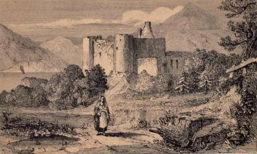
the Lorn family, which
branched off from that of the Lords of the Isles in the twelfth century But
Dunstaffnage connects with a much more remote antiquity than this; for the
received opinion is that, latterly at least, it was the residence of the
Dalriadic race of Scottish kings, who ruled over the Scots from their first
location in 503, in Cantyre, till 830, when Kenneth Macalpin united the
Scottish and Pictish kingdoms into one, and removed the seat of monarchy to
Forteviot. The lordship of Lorn, with the castle and lands of Dunstaffnage,
passed, in the fourteenth century, into the hands of the Stewarts of
Innermeath, by the marriage of the heiress to John Stewart, commonly called
John of Lorn, and in the fifteenth century into those of the Campbells of
Glenorchy—M'Dougal of Dunolly becoming chief of the clan. Dunstaffnage was
inhabited by the Lords of Argyle till the middle of the fifteenth; and was
taken possession of by Bruce after his victory over the Lord of Lorn in the
Pass of Awe. There is a highly interesting specimen of an old chapel close
by. Its architectural decorations, the most elaborate of any chapel in
Argyleshire, seems to belong to the thirteenth century. The original
building, which is only twenty-four yards by eight, is defaced by a more
modern room erected at the east end, thus obscuring the altar window or
windows, which seems to have been very beautiful, of strictly early English
form, with banded shafts, and the dog-tooth ornament. 41 triple tablet runs
all round the chapel under the windows. The spot on which it is erected is
distinguished by an echo of singular distinctness.
Our present locality is
generally admitted to be the immediate one from which the celebrated stone,
standing on which our Scottish monarchs were wont to be crowned, was
transported to Scone, and the preservation of which is, or was, a matter of
such importance in the eyes of every true Scot; as such, of course, placing
undoubting faith in the well-known couplet,-
"Ni fallat fatum, Scoti
quoeunque locatum,
Invenient lapidem, regnare tenentur ibidem."
As is well known, this
precious relic was removed to England by Edward Longshanks, and is safely
deposited beneath one of the coronation chairs in the chapel of his namesake
the Confessor, in Westminster Abbey. One or two brass guns recovered from a
vessel of the Spanish Armada, which was lost in the Sound of 'Mull, are to
be seen on the castle wall. The best view of Dunstaffnage is from the Oban
road, where it is seen to rest on the water, beyond which the bay and wooded
promontory of Ardnamucknish, backed by the hills of Morven.
Opposite the Castle of
Dunstaffnage, on the further side of Loch Etive, will be observed a
magnificent set of cliffs, called the "Cragan Righ," or King's Rocks,
formed, as the geologist will remark, of an extremely hard and singular
conglomerate, composed of a great variety of primitive and trap rocks ; and
about 400 yards in advance, and to the north-west of these cliff's, close on
the pebbly beach of the fine circular Bay of Ardnamucknish, is the little
double-topped rocky eminence, on which and the contiguous plain, conjecture
has for a long time back been pleased to fix as the site of Berigonium, the
ancient Pictish capital, which probably early waned before the advancing
fortunes of the Scottish adventurers ; as St. Columba is said to have gone
to the mouth of the Ness '(now Inverness) to convert Brudeeus, king of the
Picts, towards the close of the sixth century. It is near the shore, and
only two miles distant from Connel Ferry, and, by visiting it, the traveller
will be gratified at least by the inspection of a very good and accessible
vitrified fort. Both the flattened summits are girt with a vitrified wall,
strongly defined, and in some parts exposed, to a height of eight feet. This
rock is vulgarly called Dun Mac Snichan. Either area is an irregular oblong,
measuring respectively 160 and 100 paces circumference. They are separated
by an interval of 120 paces. The rock is barely accessible, except at one
end, where it is defended by a second wall, and at another spot about the
middle of one side, where a broad gap affords a steep approach. The
adjoining cliff is called Dun Mail an high, "the hill of the king's town."
From the foot of the cliffs a straight raised way, said to have been at one
time paved, and called Straidmharagaid, "the market street," proceeds along
the top, and at a few yards' distance from the edge of the steep green bank
which lines the beach leading to Dun Mac Snichan. It is about ten feet
broad, and, where best defined, of a like height. Some years ago a stone
coffin, an urn, and a sandal, were found in the ground behind. A hollow log
of wood, turned up at an early period, was readily construed, by the
sticklers for the regal associations fondly attached to this spot, into a
remnant of the water-pipes of the city. At the base of the cliff is a small
burying-ground and ancient cell or chapel, from Which the "street" or paved
way communicated most likely with the seashore opposite Dunstaffnag e, or
with the vitrified site, and which, therefore, was, in all likelihood, only
a procession road during Christian times to the religious sanctuary. The
distinction is farther claimed for this place of being the Selma of Ossian.
"Selma" signifies " beautiful view," in which respect the identity may
readily be admitted. As we have elsewhere observed, the range under the eye
from this spot is alike extensive and diversified. The ruins of Bercaldine
Castle are at no great distance. The view here is also fine. Intermediate is
the house of Lochnell, General Campbell.
37. Oban comes suddenly in
sight when close upon it, quite a bird's eye view presenting itself from the
heights above of the somewhat bowl-shaped road-stead, with its small
complement of shipping and boats, and the respectable looking range of
white-washed houses fronting the harbour.
If the reader will now
suppose himself again at Tyndrum, where, as already mentioned, the Oban and
Fort-'William roads diverge, we will take up the thread of description at
that point of the route as from
GLASGOW TO FORT-WILLIAM BY
LOCH LOMOND.
38. The stage of eighteen
miles from Tyndrum to King's House, is bleak and sterile. Half Way the
shores of Loch Tollie or Tulla are rather pictures(jue, being garnished with
some fine specimens of Scotch pine. Its margin forms a pleasant site for a
shooting lodge of the Marquis of Breadalbane, whose adjacent forest on the
Black Mount is distinguished foi its stock of deer. There is here also a
small public house, Inverouran. Between and King's House, a solitary inn of
moderate pretensions, standing in the midst of a bleak and extensive moor,
the road makes a prolonged and tiresome ascent across the shoulder of the
Black Mount ; the view from Which has a peculiarity in its way, ranging over
the moor of Rannoch, a vast expanse of heath intermixed with rocks and
moss-water lochs—the largest waste of the kind in Scotland.
39. Intermediate between
King's House and Loch Leven lies Glencoe, of historical notoriety, and no
less known to fame for its own intrinsic features. It bends in the centre.
The lower division near Loch Leven is covered with rich verdure, and the
course of the river marked by alder and birch trees spreading up the face of
the lower slopes of the mountains, which terminate in naked and furrowed
acclivities, of a singular intermixture of colours. The character of the
other division of the glen is that of unmingled wildness and grandeur. On
the north side porphyritic ranges rise into a continuous series of high,
naked, sharp-edged, and serrated precipices. The mountains which form the
southern boundary are more rounded, yet loftier and more bold, and they
project unequally into the glen, gashed with many a grizzly furrow. From
these inaccessible fastnesses
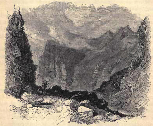
numerous torrents descend
into the plain; the streams are so rapid, and carry so much stony matter
along with them, that they cannot be conducted by drains under the road,
which thus possesses many inequalities, and is frequently rendered almost
impassable by the quantities of debris lodged upon it. A small lake,
Treachtan, occupies the lower part of this, the upper portion; above which
the glen ascends with a rapid inclination to its extremity. The impending
gloomy precipices of this wild glen are of a nature to strike the most
unreflecting mind with awe ; their ragged outlines and bold fronts, seamed
with torrents and shattered by storms, form a scene not only wonderful but
terrific. The rugged and desolate grandeur of Glencoe and its peculiar
intensity, compressed close around the spectator, is acknowledged by all,
and by none more than those who have had opportunities of seeing many of the
most remarkable scenes on the Continent of Europe. We have been struck by
the unqualified admiration of Glencoe expressed by parties familiar with
Switzerland, more especially by foreigners, who seemed peculiarly alive to
the impression of its complete desolation and unrelieved austerity of
character.
In the mountains of Glencoe
there are some very dangerous passes, the terrors of which few, but the
shepherds who are familiarised to them, would willingly encounter. The
mountains on the north side of the glen terminate so sharply as, at one
particular spot, for a space of some yards, to resemble exactly the roof of
a house. To surmount this critical obstacle, requires no little nerve and
resolution, for the only way to advance is to sit astride, and crawl
cautiously alongst the narrow ridge; yet many fox-hunters do not hesitate to
perform this trying adventure, burdened with both dog and gun. Nor is this
the whole of the exploit ; for a little further on they have to leap a
height of about ten feet from the top of the precipice, to where the slope
becomes so gentle as to make this practicable by care and dexterity. A pass
of a different nature, and more avoided, because safety depends less on
skill than accident, is in the face of the Pap of Glencoe. It is a very
steep gully, the sides of which are covered with loose stones, which any
slight disturbance brings tumbling down in great quantities. Here a shepherd
lost his life some years ago ; yet many recollect an old woman who, to a
very advanced age, almost daily followed her small flock of goats up this
dreaded hollow, unconcernedly engaged in spinning with her old-fashioned
roke and distaff. Glencoe possesses a few farmhouses, as Invercoe,
Auchnacone, Auchteriachtan, and some huts in the lower portion of the glen,
and one solitary farmhouse at the side of Loch Treachtan.
40. The well-known massacre
of Glencoe, which cast so signal a stain on King William's reign, renders
the glen a locality of no little interest in an historical point of view.
This tragic incident seems to have had its immediate rise in the
disappointment felt by the Secretary of State, Sir John Dalrymple, master of
Stair, and the Earl of Breadalbane, at the failure of a project to organize
the Highland clans into a force for the support of Government. In the
negotiations for the purpose, too, the earl had been provoked by Mac Ian,
chief of the Macdonalds of Glencoe, who insinuated that he had appropriated
to his own use part of a sum of money entrusted to him for distribution
among the chiefs. The Macdonalds altogether stood in the way of the
attempted arrangements, and those of Glencoe were ever looked upon with an
evil eye by their neighbours the Campbells,—a disposition heightened by the
Glencoe men's share in the defeat of the latter by .Montrose at Inverlochy.
On the unsuccessful issue of the project of conciliation, Government issued,
in 1691, a proclamation, enjoining the submission of all the chiefs before
the 1st of January 1692, by taking a formal oath of allegiance. All the
chieftains had complied except Mac Ian of Glencoe; and he, too, a few days
before the expiry of the appointed period, repaired to Fort-William, and
tendered his oath to Governor Hill, who, however, was not the proper
authority, and he found himself necessitated to proceed to Inverary to the
sheriff of Argyle, Sir Colin Campbell of Ardkinglass. A storm of snow
prevented his arrival within the prescribed time ; but the oath was
administered, and the certificate forwarded, with an explanatory letter. On
the 11th of the month, directions to proceed to the extremity of fire and
sword, with all who might have neglected the proclamation, were signed by
King William; and on the 16th he issued a second set of orders, but
containing, like the first, a reserved power to extend the indemnity to such
as might have delayed to comply for some little time beyond that originally
specified, yet expressly excepting the Macdonalds of Glencoe, who were
directed to be extirpated. The Sheriff of Argyle's letter was not produced
to the council, and the certificate was cancelled. Instructions of the most
savage nature were committed by Stair to Governor Hill; and a detachment of
the Earl of Argyle's regiment was, under a plausible pretext, quartered in
the glen, under the command of Captain Campbell of Glenlyon, whose niece was
married to one of Mac Ian's sons. The soldiery were most hospitably
entertained for a fortnight by their intended victims, whom, on a winter's
morning in February, they proceeded to murder in cold blood. Another party,
under the command of Major Duncanson, was to have occupied the eastern pass
; but having been prevented by the snow from arriving in due time, an
opportunity of escape was presented to the majority of the miserable
inhabitants, of whom, consequently, the number killed was only thirty-eight,
but who were murdered under circumstances of most wanton barbarity. It is
related of the principal actor in this tragedy—Campbell of Glenlyon—that
having, some years afterwards, to superintend a military execution of a
soldier, for whom a reprieve had arrived, he, at the time for producing it,
inadvertently instead dropped his handkerchief, the fatal signal to fire.
Horror-struck, he exclaimed, that the curse of Glencoe hung about him, and
in deep despondency immediately retired from the service.
41. We now reach Loch Leven,
a long but narrow arm of the sea, extending in a straight line between the
counties of Inverness and Argyle. It contracts twice to a very narrow width
: at Ballachulish Ferry, and three or four miles beyond, at another strait,
called the Dog's Ferry, above which it continues for about three miles. Dr.
MaccuIIoch, with truth, remarks, that, "from its mouth to its further
extremity, Loch Leven is one continued succession of landscapes." Amongst
the singular and lofty porphyritic mountains on the south side, which form
the entrance to Glencoe, the eye is peculiarly at-. tracted by the Pap of
Glencoe—a huge conical mountain overhanging the loch. The naked surface,
abrupt acclivities, and varied colours of the porphyritic masses which line
the glen, form a striking contrast to the green sloping shores of the loch.
In the basin between
Ballachulish and the Dog's Ferry are several islets. One of these, called
St. Mingo Isle, has long(. been used as a burying-place. It consists of two
knolls, one of which is appropriated to the district of Glencoe, and the
other to the people of Lochaber. On the latter are the ruins of a smalI
Roman (a tholic chapel, in which the body of Mac Ian, the Laird of Glencoe
above alluded to, was originally interred. Some of his descendants,
unwilling that the bones of their ancestor should repose anywhere but among
those of their own clansmen, had them removed, not many years ago, to the
Glencoe portion of the isle. They were of great size. As he was a remarkably
powerful man, his assassins were careful to pour a simultaneous volley on
him as he lay asleep, and all the balls lodged between his shoulders. He was
called iilhic Ian Vohr, "the son of John the Great," whence several of those
who escaped the massacre took the name of Johnson.
At the upper end of Loch
Leven are two objects which are frequently visited by strangers—the Serpent
River, and the Falls of Kinloch More—both on the north side of the loch. The
Serpent River near its mouth falls over a cascade about twenty feet high,
and is then hurried through a series of low natural arches, forming a dark
and almost subterranean channel. A vertical hole in the rock (communicating
with the river) admits the spectator close to the base of the fall ; the
sheeted water of the cascade throws an uncertain light over the rocky cavern
; and the successive openings of the roof give us partial glimpses of the
inky stream, threading its way through the intricacies of the tortuous
labyrinth. The Falls of Kinloch More are, as the name implies, at the head
of the loch ; their height appears about 100 feet, but they are formed
merely by a small burn, tumbling over the face of a perpendicular range of
cliffs, the birch trees at the base of which conceal the lowest part of the
fall, and thus lessen the effect which its great height-its sole remarkable
feature—would otherwise certainly produce. The trees below and along the
brow of the precipice, however, bestow an airiness and beauty on the spot,
which, with the general grandeur of the loch, and the tunnelled course of
the Serpent River, amply repay the trouble of a few hours' excursion on the
water.
42. There is a good
public-house or inn on either side of Ballachulish Ferry, sixteen miles
distant from King's House. The view from the north side is worthy of special
mention. The celebrated slate quarries, which are about two miles from the
ferry, give employment to about 200 people. Near them there is a neat
Episcopal chapel, half a mile beyond "the sounding Cona," which the road
crossing, leads along the shores of the loch to the ferry. The adjacent
district of Appin has always been a stronghold of Episcopacy. It is worthy
of remark that the number of communicants at the Ballachulish chapel has at
times been as large as 300, being probably more than in any provincial
Episcopal congregation north of the Tweed.
From Ballachulish to
Fort-William, a distance of fourteen miles, the road runs chiefly along the
eastern shore of Loch Eil. At Coran Ferry, which connects Loch Linnhe with
Loch Eil, the sides of the firth approach very near each other. The opposite
shore is here laid out into plantations and corn-fields: further down is
seen the house of Ardaour, surrounded with woods, parks, and meadow grounds
; and the sloping hills are elsewhere occasionally adorned with plantations
of birch, and cottages, most of them humble enough, but surrounded with
clumps of old trees.
Having thus disposed of the
routes to Oban by the Crinan Canal and Loch Lomond, and also by the latter
to Fort-William, it becomes our business to follow up these by some account
of the remaining lines.
FROM GLASGOW TO OBAN BY
INVERARY.
43. Of these there is a
considerable choice. We need merely allude to the access by steam through
the Kyles of Bute and Loch Fyne. The route by Tarbet on Loch Lomond may,
from the head of Loch Long, be taken in connection with that by the latter,
which, with the direction by Loch Goil Head, are the most frequented, though
Loch Eck is also deserving of notice, and the Gareloch perhaps still more
so; but by these the tourist must look more to private means of conveyance.
44. Steamers are constantly
plying to the head of Loch Long, Loch Goil Head, and Gareloch Head. Loch
Long, as its name imports, is a lengthened indentation or offset of the
waters of the Firth of Clyde, which possesses much character. Its mountains
send down into the loch a series of inclined arms or ridges of irregular and
indented outlines, closing in towards the centre of the vista. Their lower
portions are covered with coppice or brought into culture, while above they
exhibit a pleasing mixture of grey rock, purpling heath, and verdant
pasture. One of the mountains at the head of Loch Long possesses a
remarkably bold and fantastic outline, which has obtained for it the
designation of " The Cobbler." Persons inclined to hazardous adventure are
not unfrequently induced to try their skill and nerve in surmounting its
dizzy precipices; but few have succeeded in gaining the utmost summit. The
glen communicating between the inn of Arroquhar at Loch Long Head, and
Tarbet on Loch Lomond side (a distance of a mile and a-half), is open, the
bottom cultivated, the sides of moderate inclination, and heathy. During the
memorable invasion of Scotland by IIaco, King of Norway, in 1263, a squadron
of sixty ships, commanded by Magnus, King of Man, sailed up Loch Long.
Dragging their boats across the isthmus connecting it with Loch Lomond, his
followers laid waste the shores of this latter lake and its islands, in
which numbers of the neighbouring inhabitants had sought, as they imagined,
a secure refuge.
45. Glencroe, which with Glen
Lochan and Glen Kinglass in succession, communicates with the head of Loch
Fyne, resembles Glencoe, but softened down ; and with these just named, is
much and deservedly admired. It is a winding valley, with an occasional
narrow stripe of cultivated ground at the bottom, flanked by rapid slopes
broken by protruding masses of rock, and rising into precipitous
acclivities, the hills split into separate summits of varied form, and
exhibiting a jagged serrated outline. Passing into the small elevated glen,
called Glenlochan, the mountains are found disposed above a short acclivity,
in a range of dark perpendicular rock, mingled with scarce less
perpendicular grassy slopes, ascending to a considerable height, and
terminating in a sharp, rugged, and serrated outline. About eight or nine
miles from Arroquhar Inn, at the top of the ascent, a well-known stone by
the way-side invites the weary traveller to "Rest and be Thankful," words
inscribed on it, with the date 1748, by the soldiers who formed the road. It
also bears the latter inscription—"Repaired by the 23d Regiment, 1768." An
easy descent down GIen Isinglass, a fine pastoral valley, with hills rising
from the edge of its stream in a steep verdant slope, and also shooting at
top into distinct but elongated roundish, though somewhat rocky summits,
conducts us to the inn of Cairndow, with Ardkinglass House adjoining, near
the head of Loch Fyne.
46. In general character Loch
Fyne possesses no particular interest. Along the upper pant of the loch,
which is very narrow, the hills rise steeply, and immediately from the water
above the lower, occasional zone of coppice and cultivation, they are
covered with a very rich verdure, but their outline and surface are rather
monotonous, but still of somewhat conical character. Below Inverary the
coasts are yet more tame, and devoid of any striking feature, but a good
deal wooded, and for several miles contiguous to that point the hills are
completely covered with trees. Much in Highland scenery of all others, as
every one knows, is dependent on the weather, and we have witnessed as fine
effects as could be wished on Loch Fyne, looking down upon it in a sunshiny
day; or, again, in a thunder-storm, not so close at hand as to be
unpleasant, but the muttered thunder rolling deliberately along the mountain
sides, and their summits partially enveloped in broken clouds.
47. Four miles above Inverary,
on the same side, Dunedera Castle, a square tower, still inhabited, the
property and former residence of M'Naughton of M'Naughton, stands perched
upon a projecting piece of terraced ground. About ten miles from the head of
Loch Fyne, a slight indentation of some extent occurs along the western
shore: at the lower end, Glen Aray, and at the other extremity, Glen Shira,
a more flat and cultivated valley, cut through the hills at nearly right
angles to the shores of the loch. A bridge crosses the stream issuing from
each, at their respective mouths. The town of Inverary is built at the lower
end of the elongated indentation or bay, looking partly across it, and
partly fronting the loch. On a level space in front of Glen Aray, on the
south hank of the river, and slightly elevated above the sea, stands the
castle. The hills separating Glens Aray and Shira terminate in the steep
escarpments of Duniquoich, which shoots up a conical head above the
contiguous range, presenting an ample precipitous front to the town and
castle, yet completely shrouded with varied hardwood, and forming a vertical
screen of peculiar richness. From the town a wide avenue of truly
magnificent beech trees proceeds in a straight line parallel with the shore;
and turning to the right, the drive conducts to the base of the skirting
hills, and, amid a profusion of stately timber, leads backwards towards the
castle, approaching which it leads through a double row of full-grown lime
trees. Other noble trees are scattered round the immediate precincts of the
ducal pile ; and, altogether, the extent of the woods, despite of many and
sore thinnings, with the beauteous scenery of Loch Fyne, with its hilly
shores, justly entitle Inverary to a proud place in the list of
distinguished localities in Scotland. We rejoice to see the little valley of
Essachosan, a sequestered spot, through whose dense oaks even a meridian
beam could not, and even now can scarcely penetrate, speedily regaining much
of its wonted character.
48. The modern seat of ,'Callum
More, inferior to the old, castle, which it represents, is a somewhat
sombre-looking embattled structure, of two storeys and a sunk floor, flanked
with round, overtopping towers, and surmounted by a square, winged pavilion.
The rooms are fitted up with tapestried hangings and furniture, panellings
and ceilings gaily painted with fruit and flowers, and rather showy than
stately. In the saloon about 150 stand of arms, used by the Campbells at the
battle of Culloden, are arranged on either hand, and above the doorway
fronting the entrance; several of the rooms are hung with much-admired
tapestry, and others are tastefully decorated with well-executed designs.
The town of Inverary consists
of about sixty houses, the greater number of which are large and commodious
; and the inhabitants amount, by last census, to 1052. A row of houses
fronts the bay, from which the principal street diverges at right angles;
and in the centre of the latter stands the church, a new structure,
surmounted by a small spire, sedulously armed with a lightning conductor, a
precaution suggested by the destruction of the former edifice a few years
ago by the electric fluid. Opposite the church there is a neat building by
the waterside, containing the court-house and other public offices. There is
a very commodious and well conducted hotel. In a garden beside the church
there is a small obelisk, commemorative of the execution, in this place, in
1685, of several gentlemen of the name of Campbell, among the last
individuals who suffered for their unflinching opposition to Popery; and
near the quay, a beautiful stone cross from Iona has been set up.
The staple commodity of
Inverary is herrings ; those of Loch Fyne being celebrated for their
unmatched excellence. The delicious consistency of the Loch Fyne herring
fresh out of the water must he practically tested to be duly appreciated.
They taste really as of a peculiar variety of the fish, otherwise there must
be something remarkable in the fishing ground. They sell for about three
half-pence a piece in the Glasgow market. Three or four, and at times so
many as 800 boats are to be seen in pursuit of this fish immediately
opposite the town. It is highly interesting to watch the boats silently
taking up their positions towards nightfall ; or to look upon the tiny fleet
darkling in the silvery moonbeams.
TO INVERARY BY THE GARELOCH,
LOCH GOIL, LOCH ECK.
It may be best to introduce
here, the few words we have to offer on the routes to Inverary by the
Garcloch, Loch Goil, and Loch Eck, before concluding the rest of the way to
Oban.
49. Both the Garcloch and
Loch Eck, of which the first is a salt water inlet, the other a fresh water
lake, are very peculiar in character. The Gareloch, intermediate between
Dumbarton and Loch Long, transports one in imagination to southern climes,
where we picture numerous villas as a natural adjunct of a beautiful sheet
of water. Here, with much softness of natural features, we have congregated,
at least on one side, all the way from Helensburgh, a large and regular
sea-bathing village, to Gareloch Head, one long and uninterrupted series of
villas of varied architecture—not a few of them sumptuous in their
pretensions, many exhibiting much taste, and the effect not only of the
whole landscape certainly extremely attractive, but highly indicative of the
Modern wealth of St. Mungo's ancient city. These cluster at points, as
Ardincaple, The Row, and Shandon, into closer groups. About the Duke of
Argyle's handsome seat of Roseneath—of Italian design—there is some fine
timber, and there is great luxuriance in the vegetation of the whole
locality. Two silver firs, of very large dimensions,. a little off the road,
and not far from the quay, are worthy of special notice, and also an avenue
of aged yew trees. A walk of a couple of miles from the very neat and pretty
sheltered village of Gareloch Head, which is within about ten miles of the
inn and hamlet of Arroquhar, at the head of Loch Long, brings us to the
summit of the intervening range, and overlooking Loch Long at its junction
with Loch Goil—the square massive walls of Carrick Castle keeping sullen
ward upon the further shore.
50. This sombre pile—a single
high, square, or rather oblong keep, with an irregularly-shaped high wall,
enclosing a portion of the projecting rock on which it stands, by the side
of Loch Goil—and a previous scene of a different complexion, where the house
of Ardintenny (Earl of Dunmore) and the pretty adjoining village lie in a
sunny recess, encircled by wooded hills, and opening upon a
closely-embowered ravine, are the most prominent individual objects on the
sail up Loch Goil. As already noticed, the approach by the Firth of Clyde to
Loch Long and Loch Goil is exceedingly attractive; the extended panorama
characterized by great variety and strong contrasts; and by spaciousness,
without such remoteness as at all to injure the effect of any one of the
boundaries. The steamers for Loch Long and Loch Goil, and for Kilmun, come
down the Firth as far as Gouroek, before reaching across. Loch Goil is
distinguished, like Loch Long, by high, rough, and boldly-outlined
mountains, with steep green acclivities, having a considerable dash of rocky
spaces interspersed. At Loch Goilhead, Drumsainy House is surrounded by fine
woods. From the village of Loch Goilhead, where there is a good inn, a coach
starts, on the arrival of the steamer, for St. Catharine's Ferry, on Loch
Fyne, about eight miles distant, and opposite Inverary, crossing a high
ridge through a fine pastoral valley, lined by lofty hills clothed with
brilliant verdure, and known by the startling cognomen of " Hell's Glen."
The ferry is plied by a small steamer.
51. Numerous and cheerful
white-washed villas, and sea-bathing quarters, extend along the opposite
shores of Holy Loch, on the Clyde, which is deeply embayed amidst mountains
of considerable elevation. A square burial vault at Kilmunso called from St.
Mun—forms the resting-place of the bones of the family of Argyle. The villas
which bedeck the shore extend, with little interruption, all round the loch.
At the western termination of the bay, another cluster of houses commences
another series, stretching in a single row along the coast, and almost
connecting with the village of Dunoon; a bright and lively shore line thus
lying in immediate contact with heathery and unreclaimed sloping braes. A
small portion of the ruins remains, at Kilmun, of a collegiate church
founded in the middle of the fifteenth century.
52. Loch Eck, flanked by the
mountain chains within whose embrace the waters of Holy Loch insinuate
themselves, possesses as strongly-marked and picturesque boundaries as any
of our Highland lakes. It is eight or nine miles in length, but generally
not many hundred yards wide, encompassed by abrupt hills of mica slate,
rising sheer from the water, roughened with many perpendicular faces of
rock, and carpeted between with the brightest verdure; of considerable still
moderate height, separated by deep ravines, and of indented and bold
outlines. The margin of the lake is not unadorned with trees. But for the
white walls of a few respectable houses Loch Eck wears all the secluded air
of a loch in the remote Highlands, while the boldly-defined forms, yet
verdant character of its hills, constitute it a most pleasing link between
the truly alpine and more properly lowland lakes. It resembles, indeed, in
many respects, the lakes of the north of England, closely embosomed in their
own compacted mountains, verdant, closely cropped, yet of unexpettedly steep
and bold acclivity, and with outlines more independent and remarkable than
those of the Scottish mountains, yet with margents green and wooded shores
incomparably sweet. About half-way between Kilmun and Strachur, on Loch Fync,
a road strikes past Whistlefield inn, across a rather steep hill to
Ardintenny. From Loch Eck, the road to Inverary conducts through a
cultivated valley, and passing the grounds of Strachur House, and by the
sheltered inn of that name, about half-a-mile from the shore.
INVERARY TO OBAN.
53. The road from Inverary to
Oban proceeds up Glen Aray, passing through a part of the ducal policies. As
we ascend, the sides of the glen are found rising immediately from the brink
of the small river Aray, and disposing themselves into numerous irregular
eminences, all enveloped with luxuriant woods, chiefly of oak and birch The
ascending valley of trees—the clambering arrangement of the series of
eminences composing the sides of the glen—the diversity and undulations of
surface—the varied density of the forest, and its variegated foliage—the
magnitude of the timber, and its unequal age and height—the whole, enlivened
and embellished by a pleasing stream, combine to form exquisite woodland
scenery.
54. The descent to Loch Awe
is accomplished by a series of most rapid inclines, setting at defiance all
notion of easy gradients. We reach the low ground at Clady, where, besides
an inn, there is a small collection of black houses. Here, one road to the
right leads, by Dalmally, (sixteen miles from Inverary,) round the head of
Loch Awe, while another, in the opposite direction, conducts to the ferry of
Port Sonachan, three miles from Clady, crossing at which the distance is
shortened by about six miles. The former, from Dalmally, has been already
described. At Port Sonachan, the shores of the lake are found beautifully
diversified with wood and cultivated ground, and embellished by several
respectable-looking residences. The landscapes, from the successive lateral
outlines, present everywhere a variety of distances. The upland opening
towards Loch Etive is bare and cheerless—Ben Cruachan and the adjoining
ranges, however, preserving their majestic character, while we descend
through a pleasing little glen—Glen Nant—of somewhat peculiar character ;
the sides, rising for some miles immediately from the burn, being covered,
with scarce a break of rock throughout, with a thick young coppice of hazel
and dwarf birch.
OBAN TO INVERNESS.
55. We know of nothing to
surpass the sail from Oban to Fort-William. Bordered on both sides by lofty
mountains, there is yet a striking contrast on either hand. On the one, the
Morven and associated ranges line the waters in one continuous rampart,
cleft, it is true, by an occasional ravine-like opening, and several of the
individual mountains are distinctive by their fine forms. On the other, a
series of far indented inlets of the sea, though but partially visible from
Loch Linnhe, indicate a disposition of the mountain masses ranging inland
from the coast, thus exhibiting themselves to the eye of the spectator at
varying distances and in multiform shape, outline, and grouping, while, the
broken character of the shore and its diversified surface, greatly heighten
the effect. A beautiful green is the prevailing livery ; but in the
revelations made of mountain summits of great elevation, rising into peaks
or circled with precipitous corries, as, for instance, the hoary guardians
of Glencoe, the bare rock contrasts, according to its respective
ingredients, its varying more sombre or neutral hues and tints, with the
warmer colouring of the pasture, heath, and foliage. Objects of great
interest, though different in kind, occupy the nearer ground, in the
numerous strongholds in ruins, attesting the importance which the
surrounding districts held at former periods of our country's history, when
the Lords of the Isles and their Scandinavian predecessors ruled paramount
amid their remote fastnesses. Of these Dunolly Castle, at the entrance of
the Bay of Oban; Dunstaffnage, at the opening of Loch Etive; the vitrified
rock, the reputed site of Berigonium the Pictish capital, on the opposite
coast of the Bay of Ardnamucknish; Duart Castle, the stronghold of Maclean,
on the coast of Mull ; Shuna, on the island of that name ; Eileen Stalker, a
fortalice of the Stewarts of Appin, on a little islet off the Appin shore,
are the most prominent. Many gentlemen's seats, surrounded by
pleasure-grounds beautified with full-grown trees, adorn this romantic
coast. Lochnell (General Campbell) lies within the wooded promontory of
Ardnamucknish, which extends from the opening of Loch Creran to that of Loch
Etive. The house. of Airds is situated at the mouth of Loch Creran. Ardshiel
(Stewart) presents itself at the entrance of Loch Leven ; and intermediate
between them lies Appin House (Downie). The Appin coast is diversified with
numerous rocky knolls and eminences, which, with the lower mountain slopes,
are girt with rich woods of oak and birch. One of the finest points is the
opening of Loch Leven, where the aspect of the towering Alps of Glencoe, and
of the bright emerald acclivities near hand, is really imposing ; and the
pre-eminent bulk of Ben Nevis, as we advance, attracts attention, and is an
object one looks out for with some interest, as being the monarch of British
mountains, now holding a sort of divided sway with Ben Mhac Dhui in the
heights of Aberdeenshire.
Loch Linnhe, as it spreads
out towards the ocean, where the widening vista is closed by the brown
heathy mountains of Mull, encompasses with its waters a few large and
several smaller islands. Of these, the principal is
56. Lismore, a very fertile
island, about ten miles long and two broad, in which is carried on a
considerable trade in limestone, of which it is entirely composed. At
Killichearen, on the east side of the island, is a small establishment, till
lately made use of for the education of Roman Catholic priests, and called
the College of Lismore, which was under the charge of a bishop. It consists
of a small chapel, with a two-storeyed dwelling-house on each side, and
protected from the winds by a few ash trees. This seminary has, of late
years, been abandoned, and removed to Aberdeenshire. The number of students
was generally nine or ten. None of the inhabitants of the island are
Romanists. This island was anciently a possession of the Bishops of Argyle
and of the Isles, who were thence frequently styled Episcopi Lismorenses. On
the west side of the island the remains of their palace of Auchindown still
exists in the shell of a large square structure with lofty walls, which
enclose a court on one side of the building; the whole being rather securely
placed on a rock in front of a terraced space with a precipitous seaward
front.
57. Fort-William and the
contiguous village of Maryburgh stand at a bend of Loch Eil, as the
extremity of Loch Linnhe is called, which here suddenly turns its course to
the northwest. The fort was erected in King William's reign. It is an
irregular work, mounted with 12 twelve-pounders, and defended by a ditch,
glacis, and ravelin. It contains a bomb-proof magazinc, and the barracks are
intended to accommodate 2 field-officers, 2 captains, 4 subalterns, and 96
privates. We apprebend its worth as a protection to shipping, its only
conceivable use now a days, to be very small, if of any account at all. Like
Fort-Augustus, it was designed as a garrison for troops, to keep the
Highlanders in check when their loyalty was a divided one, and with the
occasion their serviceableness has passed away. A mere handful of men now
compose the garrison. Mary-burgh consists of a long straight street, close
to the edge,of the water, with several short intersecting lanes, and
contains about 1500 inhabitants; two respectable inns, the Caledonian and
George; an Episcopal and Roman Catholic chapel, and Missionary Presbyterian
and a Free church; two branch banks; and here, too, one of the
Sheriff-substitutes of the county resides and holds his courts, his
jurisdiction also extending over a portion of the adjoining county of
Argyle. A monument has recently been erected in honour of Maclachan of
Aberdeen, a distinguished Gaelic scholar and great linguist, and compiler of
the Gaelic Dictionary, who was a native of the district.
58. The most prominent
feature of this neighbourhood is Ben Nevis, "Beinmamh Bhathais," the
mountain with its summit in the clouds—the cloud-kissing hill, long reputed,
and still having fair pretensions, to be the highest mountain in Great
Britain. It rises abruptly from the plain to the east of Fort-William: its
height is 4370 feet, and its circumference at the base is supposed to exceed
24 miles. The circuit or outline of the mountain all round is well defined,
for it is almost completely isolated by two yawning ravines, and separated
from the adjoining Iofty mountain ranges, and projects boldly in front of
them. The base of Ben Nevis is almost washed by the sea; none of its vast
proportions are lost to the eye, and hence its appearance is peculiarly
imposing; while the sky outline, which is not peaked, but plain and tabular
(deviating but little from a right line), admirably harmonises with its
general massiveness and majesty. Its northern front consists of two grand
distinct ascent or terraces, the level top of the lowest of which, at an
elevation of about 1700 feet, contains a wild tarn or mountain lake. The
outer acclivities of this, the lower part of the mountain, are very steep,
although covered with a short grassy sward, intermixed with heath ; but at
the lake this vegetable clothing ceases. Here a strange scene of desolation
presents itself. The upper and higher portion seems to meet us, as a new
mountain, shooting up its black porphyritic rocks through the granitic
masses, along which we have hitherto made our way, and, where not absolutely
precipitous, its surface is strewed with angular fragments of stone of
various sizes, wedged together, and forming a singularly rugged covering,
among which we look in vain for any symptoms of vegetable life, except where
round some pellucid spring the rare little alpine plants, such as Epilobium
alpinism, Silene acaulis, Saxifraga stellaris and nivalis, which live only
in such deserts wild, are to be found putting forth their modest blossoms,
amid the encircling moss. The eagle sallying from his eyry may greet the
approach of the wanderer, or the mournful plover with plaintive note salute
his ear; but for those birds of the mountain, the rocky wilderness were
lifeless and silent as the grave; its only tenants the lightnings and the
mists of heaven, and its language the voice of the storm.
On the north-eastern side of
Ben Nevis, a broad and tremendous precipice, commencing at the summit,
reaches down to a depth of not less than 1500 feet. The furrows and chasms
in the black beetling rocks of this precipice are constantly filled with
snow, and the brow of the mountain is also encircled with an icy diadem.
From the summit, the view, as will readily be conceived, is remarkably grand
and extensive. The astonished spectator, who has been so fortunate as to
reach it free of its frequent robe of clouds, descries, towards the south
and cast, the blue mountains of Ben Cruachan, Ben Lomond, Ben More, Ben
Lawers, Schehallion, and Cairngorm, with a thousand intermediate and less
aspiring peaks. On the other sides, his eye wanders from the distant hills
of Caithness to the remote and scarcely discernible mountains of the outer
Hebrides. Numerous glens and valleys lie to the south, but they are hidden
from observation; and to the utmost verge of the horizon, countless
mountains of all sizes and shapes, heathy, rocky, and tempest-worn, extend
before the eye, as if the waves of a troubled ocean had, in their commotion,
been turned into stone. Looking towards the other points of the compass, we
meet with more variety; the silvery waters of Loch Eil, Loch Linnhe, and
Loch Lochy, of the Atlantic and German Oceans, rendering the vast prospect
more cheerful and brilliant. It may safely be said that every point of the
horizon is 120 miles removed from the spectator.
The ascent of Ben Nevis
usually occupies three hours and a-half from the base of the mountain, and
the descent rather more than half that time. Some travellers go up at night,
that they may enjoy the sunrise: by doing so, they run a great risk of being
disappointed, as in the morning the view is generally obscured by mists, and
only occasional glimpses can be caught of the glorious prospect, which is
generally clearest from midday to six o'clock in the evening. It is
imprudent for a stranger to undertake the ascent without a guide, and one
can always be procured about Fort-William for seven or eight shillings. The
inexperienced traveller, also, may be the better of being reminded to carry
with him some wine or spirits (which, however, should be used with caution),
wherewith to qualify the spring water, which is fortunately abundant, and to
which he will be fain to have frequent recourse, ere he attain the object of
his labours. It is customary to ascend the hill on the northern side. By
making a circuit to the eastward, beyond Inverlochy Castle, the traveller
can proceed as far as the lake on the back of a Highland pony.
Ben Nevis, in its geological
structure, very clearly exhibits the successive elevation of mountain masses
by volcanic agency. It consists of three great zones of rock, the
fundamental one being gneiss and mica slate, through which an enormous
irruption of granite, forming now the lower half of the mountain, bursts
forth. At a subsequent period, a new summit of black compact felspar rocks
(the principal member being a porphyritic greenstone), was projected from
below through the centre of the granite, shooting up beyond it at a high
angle, and now constituting, as similar rocks do elsewhere, the loftiest
rocky pinnacle in the country. The older masses arc, in many places,
traversed by veins of the superior rocks.
In Glen Nevis, some miles
from Fort-William, is a rocking-stone of considerable size, not unworthy the
attention of the curious ; and beyond it the vitrified fort of Dun Jardil.
59. Between Loch Lochy, the
westernmost of that chain of lakes which occupy the Great Glen and the line
of the Caledonian Canal, and the sea at Loch Eil, there is a broad moss,
which, with the adjoining district, forms the territory of Lochaber, a name
familiar to Scottish ears. On the north side of this flat the canal has been
formed, and on the south side runs the river Lochy, issuing from Loch Lochy,
with the united waters of the river Spean, which descends from Loch Laggan.
An object of interest near
Fort-William is the old castle of Inverlochy, about two miles distant from
the latter place. It stands between the road and the river Lochy, and
consists of four large round towers, connected by high walls or screens,
forming an extensive quadrangle. The towers are about thirty feet in height,
and overtop the walls by eight or ten feet. The western and southern are
nearly entire ; and the former, which is called Cuming's Tower, is
considerably larger than the rest. Its inside diameter is eight paces, and
the thickness of its walls about ten feet. A moat, eight paces wide,
encircled the walls at the distance of ten paces. The principal entrance is
on the youth-east side; and directly opposite it is a sallyport; each had a
guard-room immediately above, and the former was well defended by iron
gates, and a heavy portcullis. The towers, consisted of three storeys, and
besides loop or arrow-holes, each room is provided with one or two windows.
Tradition invests Inverlochy
with a most imposing antiquity, making it the residence of the Pictish
kings, when they came to enjoy deer-stalking on the Parallel Roads of Glen
Roy! Here, also, Achaius is said to have signed a league with Charlemagne.
The present building is most naturally to be ascribed to the age of Edward
I., being of nearly the same character as the castles erected by him in
North Wales. If not built and garrisoned by his troops, there seems little
reason to doubt that it owes its origin to the powerful family of Cuming,
and that the English monarch's engineers had helped to plan and construct
it, as the style of its defences and masonry are different from the usual
rude residences of Highland chieftains.
A handsome suspension bridge
has now been erected across the river Lochy, near the old castle,
superseding the ferry, and thus an important acquisition to the district.
60. Beneath the frowning
towers of Inverlochy the Duke of Argyle was defeated by the Marquis of
Montrose, in the year 16-I5. Montrose and his army had just retired from a
six weeks' inroad into the Argyle country; on which occasion, having taken
his enemy completely by surprise, "he burnt every house, except the
impregnable castles; slew, drove off, ate up, or otherwise destroyed, every
four-footed beast, and utterly spoiled everything in the shape of grain,
goods, and furniture." On his way towards Inverness at the hill of Kilchumin
(near Fort-Augustus) on Loch Ness side, he was overtaken by the unexpected
news of Argyle with a force double his own, which had been much reduced by
the temporary absence of his men to deposit their booty, advancing in
pursuit, and retaliating by laying waste Lochaber. Judging correctly that
another body would be ready to the eastward to act in concert with the
Campbells, Montrose, with that enterprise and promptitude for which he was
so eminently distinguished, resolved to anticipate the movements of his
enemies, and to hurl back the tide of war. lie led his men up the course of
the Tarff (the line of the old Corryarick road) to the sources of the Spey,
and thence into Glen Roy, and so, by pathless wilds covered with a deep
snow, with great expedition to the foot of Ben Nevis. This circuitous route
was chosen for secrecy's sake. It was impossible to make the attack the
night of their arrival. Before dawn the Campbells were not unaware of the
presence of a hostile body; but deeming them merely some party of the
surrounding peasantry, and little dreaming of the close vicinity of the
redoubted Montrose, slight attention was paid to the aggressing host, to
whom every opportunity was left of assailing their adversaries to advantage.
The onset was made when the first rays of the sun shot athwart Ben Nevis ;
and the astonished Campbells hurriedly drew up, dismayed by the intelligence
of the great Montrose himself being their opponent. Their chief, excusing
himself from the effects of a late accident, retired on board his galley. A
large body of his men had been posted on the further side of the Lochy; and
the main army, drawn up in the level ground about the castle, were
dispirited by being made to abide the shock of their enemies' impetuous
charge. There was scarce a show of resistance made. They were driven back in
confusion on the river and shore of Loch Eil, and slaughtered or drowned in
crowds. There fell no fewer than 1500 men, a full half of their whole
number, including sixteen gentlemen and officers of note; while, on
Montrose's side, there were only three private men killed, and one gentleman
wounded. Argyle, ordering his sails to be set, left his men to their fate.
This sanguinary battle, if it can be so called, was fought on Sunday the 2d
of February, 1645.
Montrose is said to have
knighted on the field of battle John Hay of Lochloy, whose tomb is still to
be seen in St. Mary's aisle in Elgin cathedral. This is the latest instance
of the honour of knighthood being conferred by a subject ; and the
circumstance is commemorated in the pages of our great novelist, where the
doughty Sir Dugald Dalgetty is made to win his spurs in this engagement.
Inverlochy was also the scene
of a severe conflict in an earlier age. Alexander, Lord of the Isles, having
been imprisoned in Tantallon Castle, by King James I., for burning the town
of Inverness, and other offences against the peace of the country, Donald
Balloch of Islay, a cousin of Alexander's, to insult the royal authority,
laid waste Lochaber with fire and sword. Alexander Earl of ,liar, and Allan
Earl of Caithness, being sent to defend the country, encountered the
islesmen at Inverlochy. The latter nobleman was slain, and his party
completely defeated. But Donald's star was not long triumphant ; for, the
king advancing in person to crush the rebellion, he was obliged to flee to
Ireland, whence his head was sent over to his majesty.
61. Having landed the
passengers, whose destination may happen to be Fort-William, with such as
may prefer remaining there overnight and rejoining in the
morning—conveyances running across betimes—the steamer proceeds to the mouth
of the canal at Bannavie. A very handsome and commodious new hotel has been
recently erected by the proprietor, Sir Duncan Cameron of Fassfern, ample
enough abundantly to do away with all cause of grumbling at want of room,
ofttimes, heretofore, occasioned by the over crowded state of the former
inn, and with all feeling of disquietude in the contemplation of the
possible risk of having to seek for uncertain repose on chairs or some other
uneasy substitute for a comfortable bed. This inn has been leased by the
steam-boat proprietors, Messrs. Burns—a guarantee for its being well
conducted.
Ben Nevis and its adjoining
mountain masses, with Glen Nevis, shew to peculiar advantage from the
vicinity of the night quarters, and the tourist has the advantage of
witnessing their varied aspect under the descending mantle of evening, and
when lighted up with the first rays of early dawn.
62. Near the church of
Kilmaillie, close by the adjoining village of Corpach, an obelisk has been
erected, the inscription on which, from the gifted pen of Sir Walter Scott,
the reader will allow to be worthy of insertion ;—
63. The great Glen of
Scotland is lined throughout by parallel chains of hills of considerable but
not great elevation, broken through on the north side by a series of lateral
valleys, as the openings to Glenfinnan and Loch Arkaig, Glengarry,
Glenmoriston, and Urquhart, which severally exhibit some of the most
beautiful portions of scenery to be met within the Highlands, and in each of
different character. On the opposite side Glen Spean, at the western end,
descends from Loch Laggan to the foot of Ben Nevis; but otherwise, this
range is unbroken, except by occasional ravines, sending down their streams
with more or less of headlong impetuosity. There is comparatively little
remarkable in the way of outline ; but the long vistas, though perhaps too
much akin, are very fine, and the whole scenery highly attractive, and at
different points the side scenes are exquisitely and picturesquely
beautiful.
64. A series of eight locks
at Bannavie, called Neptune's Staircase, raise the canal at once to the
level of Loch Lochy. Partly to avoid the detention of passing these, a
different steamer performs the rest of the voyage to Inverness.
The distance to Loch Lochy is
eight miles. Within about three miles of the sea, on the banks of the river
Lochy, part of the walls are still standing of a very old building called
Tor Castle, the ancient seat of the chief of the Mackintoshes, or Clan
Chattan, who at one time possessed this part of the country, and still
retain some property in the locality. In the opinion of those who are
zealous to make the most of antiquarian data, Tor Castle has been given
forth as the residence of Ban-quo, Thane of Lochaber; and there are
certainly no such conclusive materials for gainsaying this position, as
Eadie Ochiltree overwhelmed Monkbarns withal.
65. About eight miles from
Fort-William, on the road to Inverness, which keeps the south side of the
valley, a picturesque-looking bridge, appropriately called Highbridge, is
thrown across the deep and rocky channel of the Spean; but the road now
makes a detour to avoid the steep approaches to this old structure, crossing
at Spean Bridge, where there is a small inn. High bridge was built by
General Wade, and marks the spot where hostilities first commenced in the
rebellion of 1745. Reports had become current in the country of Prince
Charles having landed, and the governor of Fort-Augustus deemed it expedient
to reinforce the garrison of Fort-William. Two companies of the first
regiment of foot were accordingly sent, under the command of Captain
(afterwards General) John Scott. As they approached Highbridge their ears
were saluted with the warlike strains of a bagpipe, and presently several
armed Highlanders were observed moving to and fro on the opposite side of
the bridge. The captain, aware of the critical state of the country, and
apprehensive that a strong force had assembled to oppose his progress,
judged it most prudent to avoid an open rupture, and began to retrace his
steps to the eastward. The military were allowed to proceed unmolested, till
they had reached the loch; but then a dropping fire was opened upon them
from the steep acclivities above, where their adversaries were securely
sheltered, and their numbers concealed. Having reached the east end of Loch
Lochy, Captain Scott, suspecting a hostile reception from some Highlanders
he observed on the hills to the south of Loch Oich, determined to proceed by
the north side of that lake, and endeavour to possess himself of the castle
of Invergarry. They had not marched far, in pursuance of this intention,
when a body of the MacdoneIls of Glengarry were observed advancing against
them. Their pursuers, greatly increased in numbers, now came up; and, as
resistance could only lead to unavailing bloodshed, Captain Scott and his
party surrendered themselves prisoners, and were immediately conducted to
Lochiel's house at Achnacarry. That chief afterwards carried them with him
to Glenfinnan, where the clans were appointed to rendezvous, to be offered
to his Prince, as the first-fruits of their arms, and a happy presage of the
success of their cause.
66. Loch Lochy is ten miles
in length ; its breadth at the east end is three quarters of a mile, and
gradually increases towards the opposite extremity, where, at the Bay of
Arkaig, it becomes nearly double that width ; the depth is in some places
from seventy to eighty fathoms. The mountains on the south side of this and
the adjoining lake are continuous and unbroken beyond Lowbridge; the
opposite hills are torn by numerous gullies, but the pasture on both sides
is still of a rich green, strongly contrasting with the brown and purple
tints which the prevalence of heather will be found to give to the eastern
portion of the Great Glen; and the vista is very fine. The shores of this
lake are steep, and the hills but scantily wooded. Shortly after entering on
the lake, the house of Achnacarry, the paternal mansion of Locbiel, the
chief of the Clan Cameron, will be observed on the north, embosomed amidst
trees in the centre of a pretty wide and exceedingly beautiful valley, which
connects with Loch Arkaig, another large sheet of water. Here lived, at
least in the old structure, burnt by the Duke of Cumberland, the "undaunted
Lochiel" of the Forty-five, and his still more celebrated predecessor, Sir
Ewan Cameron, that doughty and chivalrous warrior who long set even the arms
of the iron Cromwell at defiance, having been the last Scotsman who
succumbed to his authority, and who again signalized his loyalty at
Killiecrankie. It may interest our lady-readers to learn, that Sir Ewen had
twelve daughters, all of whom were married to landed proprietors, and most
of them to heads of Clans, or of branches of Clans. A wide circle of
highland families may thus claim kindred with Lochiel. In these days, the
fair sex were of comparatively small account, when the wealth of a chief
corresponded with the number of his bearded followers. This gallant old
chief, however, on the birth of the twelfth daughter being announced as of a
lady, prophetically expressed himself, "Yes, a real lady, and every one of
them will bring me a lad!" On the opposite side of Loch Lochy, the house of
Glenfinlay (Andrew Belford) forms a handsome and conspicuous object.
Letterfinlay is an unpretending public-house, by the loch side on the
southern shore, three miles from the east end of Loch Lochy. At Lowbridge (a
collection of huts, four miles distant from, and to the west of this inn,
and situate at the entrance of Glen Gloy), the southern range of hills
extending from the Moray Firth may be said to terminate. Glen Gloy is nearly
parallel with Glen Roy (celebrated for its parallel roads), which lies south
of it, and which joins Glen Spean, lying still farther to the south, and
extending from Loch Laggan, in the direction of Fort-William. The mouth of
Glen Spean is occupied by a vast alluvial deposit, disposed in broken
sterile eminences, beyond which Ben Nevis is still seen raising his huge
bulk to the skies, terminating a range of lofty porphyritic mountains which
proceed from the further side of Loch Laggan.
67. Kinloch Lochy was, in the
year 1544, the scene of a most bloody battle between the Frasers, headed by
their chief, Hugh, fifth Lord Lovat, and the Macdonalds of Clanranald. The
captain of Clanranald dying, left a natural son, who, being grownup, took
advantage of the minority of the heir, and seized his possessions on the
west coast. The cause of the latter was espoused by the Frasers, who
assembled to recover his estates for him. On their return from the west,
they found the forces of the Clanranald had mustered at Loch Lochy, to
hazard the issue of a battle, which was maintained till nightfall with the
most desperate determination, and nearly equal slaughter on both sides. Lord
Lovat, with his eldest son, and eighty gentlemen of the clan, fell in this
memorable engagement, which is commonly known by the name of Blaranlien,
from the Frasers having stripped to their shirts. It was fought on the 15th
of July 1544. The heir of Clanranald, called Donald Gaulta, the Lowlander,
was taken prisoner, and carried to a public-house at Laggan by a party of
Macdonalds. He had killed, in the course of the day, a very powerful man,
the pride and champion of Clanranald, and was himself very severely wounded
in the head. The Macdonalds, in their cups, commenced boasting of their
several exploits, when Donald Gaulta, from his bed of sickness, remarked,
that if he were as well as he had been in the morning, he would rather,
single-handed, encounter all who were then in the room, than have to engage
again in mortal combat with the brave man who had that day fallen beneath
his sword. This taunt so irritated the Macdonalds, that they directed the
person who was to act as surgeon, when dressing the wound of their rightful
chief, to thrust the needle into his brain. Ike did so accordingly; but ere
the spirit winged its flight, Donald had time to plunge his dirk into the
heart of the faithless leech.
68. Next in succession to
Loch Lochy, and intermediate between it and Loch Ness, comes a small lake
called Loch Oich, whose surface is the summit level between the two seas.
The distance between the latter and Loch Lochy is about two miles. In the
space between these is a small village called Laggan, principally occupied
by families of the name of Kennedy, descendants of a sept originally sent
here by government to civilize the Highlanders, but whose own character
needed equal amendment, for ultimately they were found to be among the most
troublesome and untractable of the Caterans. A plain square enclosure, north
of the canal, forms the resting-place of the late Glengarry, a personage of
celebrity in his day, as the most genuine incarnation of the Celtic
characteristics of a bygone age. He was the head of one of the lines of
descendants of Ronald, eldest son of John of Isla, the lineal heir of the
mighty Somerled. As such, and alleging his to be the oldest of these lines,
he regarded himself as the true representative of the Lords of the Isles,
instead of Lord Macdonald of Sleat, whose predecessors sprung from Donald of
the Isles, son of John of Isla by his second marriage with Margaret,
daughter of Robert II., had enjoyed the title, while a recognized one. With
an ardent temperament pervaded by an all-powerful apprehension of his high
descent, and an inborn yearning after the spirit and appropriate qualities
of his ancestry, his life was an incongruity to modern modes, and wore in
these degenerate days much of an air of extravaganza. Still his strongly
rooted feelings and startling peculiarities commanded no little general
interest, while in many a Highland bosom he stood enshrined as the model of
all to which the memory of Highlanders tenaciously clings ; and his death
left a blank which there was none to replace. It is perhaps not incorrect to
say that Glengarry's enthusiastic passion for every thing Highland may have
been a chief means in sustaining and nourishing those predilections for
Highland costume, music, dancing, and games, which are now so much a
fashion.
69. Loch Oich is rather more
than three miles and a half in length, and varies in breadth from one-fourth
to one-sixteenth of a mile. It is a sweet sheet of water, encircled by
verdant banks, with some cultivated grounds at the mouth of Glengarry; and
it is farther embellished by one or two diminutive islets, decked with
trees. The range of hills on the south side is high, steep, and unbroken,
rising immediately from the loch, but covered with green pasture, and having
a few birches scattered over its surface ; from the north side the Glengarry
mountains shoot up in a succession of high and bold peaks, very elegantly
and regularly shaped; one of them, from its uniform outline, being called
Glengarry's Bowling Green. From their base, the valley and river from which
they take their general name are seen stretching to the westward, and
beautifully fringed with birch woods. Near the river's mouth, and close to
the loch, are the ruins of the ancient castle of Invergarry, the seat of the
chief of the branch of clan Coila, called Atacdonell, and a modern mansion,
now occupied by Lord 'Ward, who has recently become proprietor, by purchase,
of the larger portion of the Glengarry estates. The latter is a plain,
narrow, high-roofed house ; but the castle is worthy of more notice. It
stands on a rock, which is the gathering place of the clan Macdonell, whose
war-cry, now the motto of their chief, is, "Craggan an phithick," "the rock
of the raven." The castle consists of an oblong square of five storeys,
containing the principal rooms, and having an addition on one side, in which
are the gateway, staircase, guardrooms, &c.; the former is rounded at the
east end into a sort of tower; from the corner of the other a turret shoats
up, which commands an extensive view of the surrounding country. It was
burnt, after the rebellion of 1745, by the Duke of Cumberland; but the
greater part of the walls are still standing. The landscape, looking back
westwards as the boat passes along to the eastern extremity, is one of the
most perfect pictures in the whole course of the voyage, and the scenery of
Loch Oich is said to resemble very strikingly that of some parts of the
Rhine.
70. A monument will be
observed by the loch side, before we reach the castle, erected by the late
Glengarry, over `1 the well of the seven heads." The monument consists of a
group of seven human heads carved in stone, placed on the top of a small
pyramid, which rests on a square die. The following inscription is engraved
on this singular structure in four different languages—English, Gaelic,
French, and Latin :—
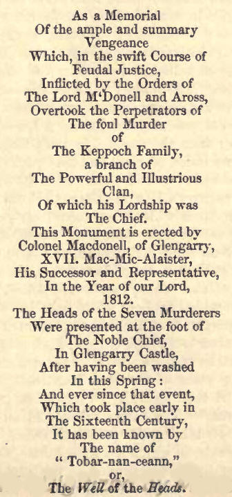
The murder alluded to was
that of the two sons of Keppoch, who had been sent to be educated in France.
During their absence their father died, leaving his affairs under the
management of seven brothers, his kinsmen. The prolonged stay of the young
chief had so habituated his cousins to the pleasures of power, that they
murdered him and his brother on the night of there unwelcome return. The old
family bard was the means of bringing the deserved punishment on the
murderers. After fruitless endeavours to engage various Highland chiefs in
the object he had devoted himself to, and repeated applications to
Glengarry's ancestor according to the above inscription, hut, in the opinion
of many versant in traditionary lore, to Macdonald of the Isles, he at
length prevailed on one or other of them to furnish a body of men, with
whose aid having achieved his purpose, the attached senachie glutted his
thirst for revenge by mutilating the corpses of the ruthless assassins. A
little way up Glengarry, on the north side of the loch, to which side the
road follows, and south-east side of the river, the traveller will find a
comfortable inn, equidistant (i.e., about seven and a half miles) from
Letterfinlay, on the banks of Loch Lochy, and Fort-Augustus. The drive up
the glen to Loch Garry is well worthy of a spare hour.
71. The centre of the glen,
from Fort-Augustus to Loch Oich, is occupied by low, rocky, and heathy
hills, on the south side of which the road proceeds, and on the other the
canal. About a mile from the fort the road passes a small loch called
Culachy, at the end of which it is joined by the southern Loch Ness and the
Corryarick roads. The distance from Loch Oich to Loch Ness is five miles and
a half. At the east end of the former lake stands a bare slated house,
called Aberchalder, where Prince Charles' forces gathered before crossing
Corryarick for the low country. Nothing remarkable occurs on the line of the
canal, except the vitrified fort of Torduin, which communicated with Dun
Jardil on Loch Ness, and thence with the eastern coast.
72. Fort-Augustus is situated
at the south-western extremity of Loch Ness ; it stands by the edge of the
lake, on an alluvial bank, between a mountain stream, called the Tarff, and
the river Oich; the canal, which cuts through the glacis at the fort,
intervening between it and the latter. The fort was built shortly after the
rebellion of 1715. In form it is square, with four bastions at the corners,
on which can be mounted twelve six-pounders. It is defended by a ditch,
covert way, and glacis. In the ditch is a battery, on which can be mounted
four six-pounders. The barracks are constructed for one field officer, four
captains, twelve subalterns, and 280 rank and file. The magazine,
storehouses, &c., are at present empty, and the guns have been removed to
Fort-George; but a few soldiers are generally stationed in the garrison.
73. Loch Ness is between
twenty-three and twenty-four miles in length ; it varies in breadth from
three quarters of a mile to a mile and a quarter, the latter being the
average width. Its sides sink with a very rapid declivity, as it is
frequently from forty to fifty fathoms deep within that distance from the
shore; and in some places, towards the middle, the depth has been found to
be 130 fathoms. In consequence of this great depth, the loch never freezes,
and the river which flows from it has so short a run, that it reaches the
sea before it has been cooled to the congealing point. The slope of the
sides of the mountain-chains is equally steep above as beneath the surface
of the lake. Rugged, heathy, and rocky, with their faces in many places
furrowed by the winter storms, they are, notwithstanding, in great part,
especially on the northern bank, luxuriantly clad with a profuse variety of
forest-trees; birch, oak, ash, elm, and aspen, and a thick underwood of
hazel, sloe, and holly; spangled in summer by innumerable wild roses, and
resting on a carpeting of purpled heath and verdant bracken. The mountain
ranges average between 1200 and 1500 feet in height, and are, in general, of
equal elevation on the opposite sides of the lake, except where
Mealfourvounie, about midway on the north side, rears his dome-like head to
the height of upwards of 3000 feet. The mountains are continuous and
undivided, save by the valley of Urquhart and Glenmoriston on the north, and
by two ravines about the middle of the south side, and near each other, down
which the Farikaig and Foyers pour their streams into the great reservoir. A
few arable tracts, at wide intervals, gladden the eye amid the woods which
cover the sides of the hills; and on the north, the openings of Glens
Urquhart and Moriston display to view large cultivated fields and
substantial houses; while in the spaces between these valleys the steep
acclivities have, in a few places, been turned to account by the labours of
industrious croftsmen. Along the whole of the southern side of the lake
hardly a house is to be seen from Dores, at the east end, to Fort-Augustus,
except towards the centre, where the white walls of Boleskine and the
General's Hut make a conspicuous appearance high up on the hill face; while
the house of Foyers below, at the mouth of the river of that name, looks out
from amidst luxuriant woods of birch.
Loch Ness occupies the whole
breadth of the valley, except towards its eastern extremity, where its
waters are confined to a narrow channel on the north side.
The appearance of this lake
from the water, though highly beautiful, is monotonous ; the mountains are
deficient in striking outline, and appear, if not somewhat insignificant, at
least wanting in force of character, from the extent of space which the eye
embraces ; and their fine woods have little better effect than a clothing of
sward. Notwithstanding, there are some very fine frontlets, as Strone Muichk,
and Craig Ian, at Invermoriston; the face of Suchumin, at Fort-Augustus ;
the Red Rock at Aultsigh ; and the Black Rock at Inverfarikaig. We would
recommend the stranger to travel along the banks of Loch Ness. Of the two
roads, that on the north side is preferable ; the elevations of the roads
are more various, and the windings more numerous ; and from these the lake
is at almost each successive step presented under a new aspect. At times,
from some treeless swelling of the hill side, or from the top of some abrupt
precipice, we overlook the whole bright expanse of its waters; whilst
advancing but a few paces, we find it concealed from sight, or, at
intervals, perceive it glittering and glancing through the dense foliage of
o'erhanging trees.
74. Invermoriston, the first
place of call after leaving Fort-Augustus, lies in a deep recess at the
mouth of Glenmoriston, closely girt by an amphitheatre of hills, with the
mansion of the proprietor (Murray Grant) fronting the lake. About three
miles further down, the deep burn course of Aultsigh presents a magnificent
precipice, bearing on its rocky ledges a host of scattered pines, which on
the more inclined surface to the lake give place to a rich mantle of birch
and hard woods.
75. The celebrated Falls of
Foyers occur on the river of that name about twelve miles from
Fort-Augustus. The steamer lies to, off the mouth of the river, at a
beautiful wood-embowered alluvial hank, from whose foliage the house Of
Foyers peers forth, to give the passengers an opportunity of visiting the
falls, which are two in number, the nearest about a mile from the lake, and
the other about a quarter of a mile further.
The river Foyers, after
passing across the highly elevated and chiefly moorland and open district of
country lying to the south of Loch Ness, on its reaching the hills which
skirt that lake, enters a deep and narrow ravine, at the commencement of
which it is precipitated over a ledge of rock, about thirty feet in height,
forming the upper fall. To view it to the best advantage (and the traveller
should, if he have command of his time, first visit this upper fall, to
which the public road and a bridge across the river will lead him), it is
necessary td descend to the channel of the river below the bridge. From this
position, the appearance of the headlong and tumultuous mass of waters is
very imposing; while the high and perpendicular rocks between which the
river pours its noisy and troubled flood, and the aerial single-arched
bridge which has been thrown across the chasm, have a highly picturesque
effect. A pathway will be found immediately beside the bridge, and on the
west side of the stream, which conducts to the proper point of view. It is,
however, somewhat difficult to reach this position; and the generality of
visitors content themselves with the view from the bridge or the rocks above
the fall. Below the fall, the channel of the river is deep and rocky, and
shelves rapidly down towards the lake: the mountain sides are clothed with
luxuriant woods of birch; and the river, interrupted in its course by
numerous masses of rock, is lashed into foam, and hurries impetuously
forward for about a quarter of a mile. It then encounters a second abrupt
descent, and is dashed through a narrow gap, over a height of about ninety
feet, into a deep and spacious linn, surrounded with lofty, precipitous
rocks. From one side of this gulf, a high ledge of rock, projecting in front
of the fall, obstructs all sight of it from any point along the margin of
the river. As we approach this greater cataract, the ground is felt to
tremble from the shock of the falling water; and the ear is stunned with its
sullen and ceaseless roar. A winding footpath strikes off from the public
road, at the commencement of a parapet wall, and leads down to a green bank,
on the point of the projecting barrier, directly opposite to and on a level
with the middle of the fall. Here in security the eye can scan the terrors
of the troubled gulf beneath, the whole extent of the fall, and of the
encircling and surmounting rocks, partially covered with a rank mossy
vegetation, forced into life by the volumes of vapour which float around,
their summits waving with birches, pencilled on the sky. The accompaniments
of wood and rock, and mountain slope, are always attractive ; but when the
river is swollen with rain, the scene assumes the features of sublimity, and
the spectator, immersed in an agitated and drenching mist, regards it with
mingled feelings of awe and admiration. The living spirit of the waters
wakens, with thundering call, the echoes of the solitude: every other sound
is drowned, and all nature seems attentive to the voice of the falling
element; and the mighty caldron is filled with shifting masses of spray,
frequently illumined with the bright and lambent tints of a rainbow.
Of the many descriptions
extant of this fall, we have always felt the following lines the most
correct and graphic:
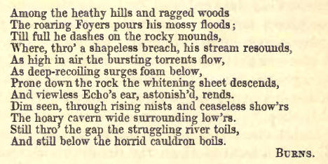
About an hour's space is
allowed to passengers desirous to visit the falls, or rather the lower fall,
as this does not suffice for both.
From the rocks surrounding
the lower fall, the spectator commands a fine view of Loch Ness, backed by
the steep and ample sides of Mealfourvonie ; while at his feet sweeps the
precipitous bed of the river, a rugged ravine of great depth, with here and
there a trembling aspen or gnarled pine; and beyond, the hill side descends
to the lake, beautified with woods of waving birch, and the smiling parks
around the house of Foyers, which occupies a site of surpassing beauty,
where the spent torrent, still and motionless, joins its waters to the lake.
The beach at the landing place is abundantly covered with columbine, a rare
indigenous plant in our northern latitudes.
76. About two miles below the
Foyers, the deep defile of Inverfarikaig gives, a glimpse of a very romantic
pass guarded at the entrance by a lion-shaped hill, called the Black Rock, a
noble precipitous frontlet, which is surmounted by the vitrified fort of Dun
Jardil. Intermediate between Inverfarikaig and Foyers, is the inn called the
General's Hut, and the house of Boleskine, in the vicinity of which Prince
Charles was received by Lord Lovat shortly after the disastrous issue of
Culloden.
77. On the western promontory
of the bay of Urquhart, (about two miles from Drumnadrochet) stands the
ruins of a venerable stronghold—the Castle of Urquhart, often noticed in the
annals of the Stuarts and earlier Scottish monarchs. It overhangs the lake,
and is built on a detached rock, separated from the adjoining hill, at the
base of which it lies, by a moat of about twenty-five feet deep and sixteen
broad. The rock is crowned by the remains of a high wall, or curtain,
surrounding the buildings, the principal of which, a strong square keep of
three storeys, is still standing surmounted by four square hanging turrets.
This outward wall encloses a spacious area, and is in some places terraced ;
and in the angles were platforms for the convenience of the defending
soldiery. The entrance was by a spacious gateway, between two guard rooms,
projected beyond the general line of the walls, and was guarded by more than
one massive portal, and a huge portcullis, "to make security doubly sure."
These entrance towers were much in the style of architecture peculiar to the
castles of Edward I. of England; and in front of them lay the drawbridge
across the outer moat. The whole works were extensive and strong, and the
masonry was better finished than is common in the generality of Scottish
strongholds.
The first siege Urquhart
Castle is known to have sustained was in the year 1303, when it was taken by
the officers of Edward I., who were sent forward by him to subdue the
country from Kildrummy, near Nairn, beyond which he did not advance in
person; and, of all the strongholds in the north, it was that which longest
resisted the efforts of his arms.
Alexander de Bois, the brave
governor, and his garrison, were put to the sword. Sir Robert Lauder of
Quarrelwood, in Morayshire, governor of the castle in A.D. 1334, maintained
it against the Baliol faction. His daughter marrying the Laird of Chisholm
in Strathglass, the offspring of their union, Sir Robert Chisholm of that
Ilk, became Laird of Quarrelwood in right of his mother, and constable of
Urquhart Castle in right of his grandfather. After this period it is known
to have been a royal fort or garrison ; but it is very likely it was so also
at the commencement of the fourteenth century, and existed as such in the
reigns of the Alexanders, and other early Scottish sovereigns. In 1359 the
barony and castle of Urquhart were disponed by David II. to William Earl of
Sutherland and. his son John. In 1509 it fell into the hands of the chief of
the clan Grant, and in that family's possession it has continued to this
day.
The mouth of Glen Urquhart
presents a wide expanse of cultivated land, reaching to the hill tops, and
diversified with wood.
As we near the foot of Loch
Ness, from its contracted limits, we discern, on the south side, the
mansion-house of Aldourie, the residence of Mr. Fraser Tytler, sheriff of
Inverness-shire, and the birth-place of Sir James Mackintosh.
A narrow strait connects Loch
Ness with the beautiful wood-encircled waters of Loch Dochfour. On the flat
gravelly neck or peninsula, which divides this little loch from Loch Ness,
are the traces of a small Roman encampment, which communicated with another
near the late inn of Pitmain in Badenoch, and was thus the station furthest
advanced into the heart of Caledonia by these masters of the world. Chalmers
says this spot is called the British Boness, that is, the foot or lower end
of Loch Ness, which the Romans latinized into Bonessia, and Ptolemy into
Banatia. It is an oblong square, rounded at the corners, and encircled by
ramparts of earth, and an irregular ditch from twenty to forty feet wide.
But these remains have recently been a good deal defaced in the formation of
a towing-path for vessels. On a square mound closely adjoining stand the
foundations of an old baronial keep, called Castle Spirituel, and which in
ancient days must have completely commanded the passage of the neighbouring
fords over the river Ness.
Dochfour House (Baillie), a
large shewy mansion in the Venetian style, with its fine old trees and lawn,
and terraced gardens, lining the water's edge, is one of the most delightful
residences in the county.
78. The canal runs for
greater part of the remaining distance to the east sea along the north bank
of the river Ness, and commands a fine view of the fertile valley of the
Ness, the wooded face of the broad terrace, which lines it on the south, and
the cultivated sloping expanse of the Leys behind, with the mansion-houses
of Leys, Ness Castle, Ness-side, and a succession of villas as the boat
nears her destination, whence the eye ranges over a beautiful section of the
Moray Firth, hounded by two opposing gravelly promontories, on one of which,
midway across the water, may be observed the walls of Fort-George. Passing
between the alluvial eminences Torvain and Tomnahurich (the latter a
remarkable artificial-like structure resembling an inverted ship) the
steamer stops at Muirtown Locks, below the vitrified fort Crag Phadrick, and
within a mile of Inverness, which lies on the plain at the river's mouth on
the right, where vehicles are always in attendance to convey passengers to
the different hotels, the Caledonian, Union, and New Royal. On the top of
the ridge of the Leys, stretching eastwards from Loch Ness, in the line of
the town, lies the battlefield of Culloden.
As the national work, by
which we have supposed the tourist to have thus made his way to the capital
of the Highlands, is an object of general interest, and has now been
completed, a more detailed history and description than has yet been given
to the public may be acceptable.
79. One of the most prominent
features in the geography of Scotland is, unquestionably, that great opening
which extends from the shores of Caithness, directly across the island,
through the shires of Inverness and Argyle to the Atlantic Ocean. The
principal part of this valley or opening is occupied, as we have seen, by
the waters of two arms of the sea, Loch Linnhe and the Moray Firth; and of
the space of land between these two, which is only sixty miles in extent,
nearly two-thirds, the reader is aware, are covered by a series of fresh
water lakes. To the plains and low hills fringing its eastern entrance
succeed, towards the interior, chains of rugged mountains, which gradually
increase in height, and attain the greatest elevation in Britain at Ben
Nevis, near Fort-William, which rises 4370 feet above the sea.
This valley, commonly called
"Glen More nan Albin," the "Great Glen of Scotland," divides the county of
Inverness, as well as the northern part of the kingdom, or in other words
what are called the Highlands, into two nearly equal portions. The large
lakes it contains seem naturally to have invited the hand of man to connect
the Atlantic and German Oceans; and such a communication was at length
projected, and has since been formed, on a scale worthy of the grandeur and
genius of the British people.
Being one of the most
important public works in the north of Scotland, a short history of it
cannot fail to be acceptable, and we hope that our readers will not deem the
following particulars too lengthy.
80. Although the subject of
internal improvement in the Highlands found more or less favour with the
public, after the suppression of the rebellions of 1715 and 1745, it is not
generally known that the scheme of a navigable canal from Inverness to
Fort-William engaged attention at so early a period. In 1773, the trustees
for the forfeited estates employed Mr. James Watt, afterwards so celebrated
in connection with the improvement and application of the steam-engine, to
make a survey of the line, and furnish them with a report and estimate of
the expense of making a canal of ten feet water, which he did; but no
further steps appear to have been taken at that time, the forfeited estates
being soon afterwards restored. The leading objects and advantages of such a
communication, however, have never been more accurately or succinctly
expressed than in the following extracts from Mr. Watt's report ; with this
difference only, that they are even more applicable to a canal upon a larger
scale than was then contemplated "All vessels going from Ireland, or the
west coasts of Britain, to the east coasts of the island, to Holland, or to
the continent of Europe north of it, and vice versa, together with vessels
trading between the east coast and America, must either pass through the
British Channel, or go north-about, that is through the Pentland Firth, or
through the sounds of, or round the Orkney Islands. At all times going
north-about is the readiest passage for the northern parts of the island;
and in time of war the danger from privateers in the British Channel, and
the height of insurance upon that account, are so great, that many ships, to
which that passage would naturally be convenient, are obliged for security
or economy to go north-about.
"Wherever a great promontory
or termination of a main land is to be passed round or doubled, it is well
known to mariners that, from the variety of winds that are necessary, and
from the storms which rage with greater fury at those headlands than upon
other coasts, the voyage is more tedious, as well as more dangerous than
others of a like length that lie in a direct course. This is remarkably the
case with the Orkney passages, to which the northern situation greatly
contributes. Besides other inconveniences, they are subjected to periodical
winds that blow violently for months together from the east or west, which
renders it not uncommon for vessels to be detained six weeks or two months
in those harbours. In the winter season, the risk of shipwreck on these
boisterous seas is very great, and consequently that passage is little
frequented then, and insurances are high. The greatest loss of time in the
northern passage generally happens about the Orkneys, as it is there that
the winds which brought the vessels northward cease to be of any further
service to them, and the seas are generally too stormy to permit them to
work to windward.
"From this view of the
subject, it appears that a communication such as is here described, between
the German Ocean and Atlantic, which would be shorter, more secure, both
from the dangers of the sea and from privateers, and also more certain in
all seasons than that by the Orkneys, would be more acceptable to all
vessels capable of passing through it, even though it were loaded with a
toll."
Mr. Watt's estimate for
making a canal, with 10 feet water, and 32 locks, each 90 feet long by 25
feet wide, and having a fall or rise of 7 feet (much on the same scale as
the present Forth and Clyde Canal, was about £165,000, equivalent of course
to a much larger sum of the present day.
81. About the beginning of
the present century, in consequence of the gradual conversion of the country
into extensive sheep-walks or stock-farms, a general movement of emigration
had begun to take place, which threatened the almost entire depopulation of
the Highlands. According to the political doctrines which then continued to
prevail, any tendency to this result was regarded with much anxiety and
alarm; it was pressed on the attention of the government as an evil
demanding instant remedy or alleviation; and the urgency of providing
employment for the numerous poor inhabitants deprived of their former
holdings, was almost universally admitted. In conjunction with other public
works proposed at first chiefly with this view, and embracing the
construction of new roads, bridges, and harbours, throughout all parts of
the Highlands, the project of a navigable communication through the Great
Glen was again revived; and in the year 1803-4, Messrs. Telford and Jessop,
civil engineers, were employed, by Commissioners appointed by Parliament, to
survey the line of the intended canal, and to report on the estimated
expense. These gentlemen recommended its formation on a scale of
unprecedented magnitude ; and after a reference to the most eminent
authorities of the day, including Mr. Rennie, Captain Huddart, and other
well known names, the preponderance of evidence was in favour of adopting
their views, which were accordingly sanctioned by the legislature. The
dimensions of the canal originally resolved on were as follows, viz.—" The
bottom width 50 feet, with slopes of 18 inches to a foot ; so that by a
depth of cutting of 15 feet, earth will be obtained to make the banks
contain 20 feet depth of water, which will be 110 feet in width at its
surface." These dimensions, however, were afterwards somewhat modified in
the execution of the work. The locks and other appendages to the navigation
were to be of corresponding size ; and, in short, to give a more exact idea
of what that size was, the canal was everywhere to be fitted for the
reception of a thirty-two gun frigate of that day, fully equipped, and laden
with stores. It is almost needless to observe, however, that the same
dimensions would not answer for a vessel of that class now, ships of war
having since been increased in their relative proportions. The aggregate of
the various estimated expenses was £474,531, exclusive of any allowance for
the purchase of land or damages, it being expected that the landowners would
consider the benefit to their properties as a compensation for what should
be cut away. The charge of executing the whole works of the Caledonian
Canal, as it was now termed, together with the other extensive improvements
in the Highlands, ultimately devolved upon Telford alone ; the choice and
confidence of the government being still further confirmed by his
professional achievements in other parts of the kingdom, as well as abroad,
which soon raised him to the distinguished position of the first engineer of
the day.
82. The canal consists of a
series of navigable cuts, connecting the upper terminations of the 'foray
Firth and Loch Linnhe with the inland lakes, and those lakes, viz., Loch
Ness, Loch Oich, and Loch Lochy, with each other; involving no less than
eight several junctions, each attended with its own peculiar difficulties,
and thereby counteracting in a considerable degree the saving caused by the
lakes in the necessary extent of excavation. The summit level is in Loch
Oich, which, receiving abundant supplies of `eater from a series of upper
lakes discharging into it by the River Garry, is admirably adapted for a
canal of partition. The surface of Loch Oich, when at its usual summer
height, stands almost exactly 100 feet above high-water mark at Inverness
and Fort-William; when very much flooded, this elevation is occasionally
increased by 4 or 5 feet. The whole length of the passage from sea to sea is
601 miles; and such is the remarkable continuity of the lakes, and of the
intermediate tracts through which the canal is carried, in nearly a uniform
direction, that this distance exceeds that of a straight line drawn on the
map from one extremity to the other by a difference of from only from 3 to 4
miles. Indeed, the distance might have been still further shortened, and
both entrances of the canal very materially improved, if the facilities
which the advancing state of engineering knowledge has since rendered
available had at first been foreseen, or could at that time have been fully
relied on. We subjoin a more detailed statement of the lengths of the
respective portions included under the general designation of the Caledonian
Canal, viz.—
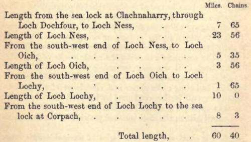
of which there pass through
lochs or lakes 381 miles, and there are of canal cutting 22 miles; but in
addition to the 22 miles of dry cutting, a considerable part of Loch Oich,
and also portions of Loch Lochy and Loch Dochfour had to be deepened by
dredging.
Some further particulars in
relation to a work of this unusual magnitude may not be deemed superfluous
or uninteresting. The locks are each 170 feet, and where two or more are
contiguous, 180 feet in length, and 40 feet in breadth, with an average rise
or lift of 8 feet. The whole number of locks, as originally built, is 28,
viz., the entrance-lock at Clachnaharry, constructed at the termination of
huge embankments forced out into deep water in Loch Beauly; the lock between
it and the capacious artificial basin at Muirtown, (occupying a space of
more than 20 acres); four connected locks at the opposite extremity of the
basin; the regulating lock a little below Loch Dochfour; five contiguous
locks at Fort-Augustus ; one called the Kytra Lock, about half-way between
Fort-Augustus and Loch Oich ; the regulating lock at the north-east end of
Loch Oich; two united locks between Lochs Oich and Lochy, near a village
called Laggan; the regulating lock at the opposite end of Loch Lochy; grand
series of locks, eight in number, at Bannavie, within a mile and a quarter
of the sea, and commonly called Neptune's Staircase; two locks descending to
Corpach Basin; and the entrance or sea-lock at Corpach. Some few of the
earliest-constructed lock-gates are of timber, wholly English oak, but by
far the greater number are framed of cast iron, and sheathed with pine
planking. The canal, in the course of its length, is crossed by eight public
bridges, which are of cast iron, and swing horizontally. Along the reach of
six miles, extending from Loch Lochy to Bannavie, the path of the canal is
also crossed by several mountain streams, some of which are conducted under
it by arched culverts or tunnels of large dimensions, and others allowed to
empty into the canal itself. For drawing off the excess of water brought
down by these last during heavy rains, three powerful sluices are
constructed at a point where the canal is cut through rock, nearly
adjoining, but at a considerable height above, the river Lochy. The action
of these is in itself a sight well worth witnessing; the water, when issuing
from the triple sluice, falls nine or ten feet before it strikes the rock
over which it tumbles, and creates an inundation over the flat land which
intervenes between the canal and river Lochy. No artificial cataract exceeds
the fury and the foam with which this emerges from its rocky
cavern—emulating in romantic effect the wildest of our mountain falls. Loch
Lochy was raised, and is since sustained, twelve feet above its natural
level; to effect which alteration, an entirely new channel had to be cut for
the river Lochy, which now discharges itself into the Spean at Mucomer. The
immense body of water, in time of high flood, conducted in nearly a level
course to this point—where, immediately after passing under the arches of a
lofty and picturesque bridge, it falls at once some twelve or fifteen feet,
over broken and precipitous rocks, into the lap of one of its own
tributaries—presents a grand and imposing spectacle, and exemplifies in
perfection both the "torrent's smoothess," and its "dash below." In fact,
the vast accumulations of water not unfrequently brought down by the winter
storms and floods, of which the great valley is the natural recipient, and
which are now everywhere required to be subjected to artificial control, are
such as the summer tourist can have no adequate conception of ; seeing, as
he does, only placid lakes, limpid streams, verdant banks, and, in short,
both nature and art in simpering mood and holiday attire.
83. After years of incredible
labour and perseverance, surpassed only by the still more gigantic
operations to which a different form of inland communication has more
recently given rise, and after surmounting many formidable and unexpected
physical difficulties, the canal had gradually advanced far towards
completion; but the expense had already very much exceeded the original
estimates, and the usual obloquy fell upon its promoters and managers. The
excess of expenditure in this case, however, was not so much due to the
natural difficulties of the undertaking, for which of course some allowance
must necessarily have been made, as to the great rise which took place in
the prices of labour and materials during the long progress of its
execution. The difference in this respect was such as, in various cases, to
have more than doubled the prices originally calculated on; and, as a single
instance of what occurred, owing to the vast quantities of oak timber drawn
from the principal forests for the supply of the navy during the heat of the
war, the price of that article amounted to an entire prohibition, and was
the cause of cast-iron being substituted, as has been said, in the formation
of the lock-gates. Explanations of this kind, rational as they might now be
deemed since the history of railways has familiarised us with cases of
infinitely more glaring disproportions, were found insufficient to appease
the wide-spread discontent and clamour for economy, arising out of the
collapsed state of public credit, and general depression of the trading
interests, which followed upon the close of the late war. On the selfish
principles which had dictated the spurious liberality of many at an earlier
period, the Highlands had now ceased to be of importance as a nursery of
thews and sinews for the national defence; and doubts, not merely of the
utility, but of the actual practicability, of completing the canal for the
purposes of commerce, were loudly expressed. Much opposition was latterly
given, therefore, to the annual grants by Parliament for the further
prosecution of the work, which were now reluctantly doled out, and at length
entirely discontinued. In this humour of the public mind, and to obviate the
objections urged on the score of utility and practicability, it was resolved
to open the canal in its then unfinished state, with the limited depth of
water which a few temporary expedients could command; and, accordingly, that
event took place, with due ceremony, in October 1822, when the late Charles
Grant, Esq., for a long period Member of Parliament for the county of
Inverness, (the most zealous and active of the Canal Commissioners,) gave a
splendid fete to about seventy gentlemen who accompanied him in a
steam-barge, the first vessel that passed from sea to sea.
The following is an abstract
of the sums disbursed by the Canal Commissioners, as appears from their
Report of the 23d of May 1827, showing the total expenditure from the 20th
of October 1803, to the 1st of May 1827; and from this summary, keeping in
view the primary object with which the canal was originally undertaken,
namely, the employment of the native population, and the diffusion of useful
arts and industrious habits among them, some estimate may be formed of the
extent to which those beneficial results must necessarily have been
realized:—
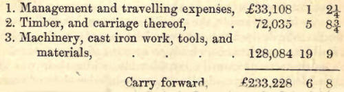
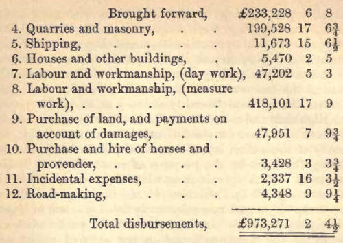
84. At or before this period,
as already noticed, the appropriation of funds towards the original
formation and completion of the Canal, may be said to have ceased ; and the
expenditure for many years subsequently was chiefly limited to its
maintenance and repair. Immediately on its first opening, a regular
communication was established, and has since been maintained, between
Inverness, Glasgow, and the west coast generally, by means of steam-boats.
It likewise afforded facilities for the exportation of a large quantity of
fir, birch, and other timber from the interior of the country to the
collieries, and for the purposes of the herring fishery. In addition to
these, the chief intercourse on the canal was confined to vessels employed
in the coasting trade between the opposite sides of the kingdom, with
occasionally a few of the smaller Baltic traders. Owing, however, to the
temporary and imperfect nature of the expedients resorted to in the first
instance for opening the canal before the works had been properly completed,
it was found that even the limited depth of water thus attained was not to
be depended on; and from the absence of many essential facilities for the
convenient transit of vessels, the traffic, although at times by no means
inconsiderable, showed little or no tendency to increase. The revenue
derived from it proved inadequate to the expense of ordinary maintenance,
which, on account of the great scale of the works, was necessarily
considerable, while their use was limited to the accommodation of a very
inferior class of vessels to that for which they were designed. The
consequence was that the unfinished works soon fell into premature decay ;
the former temporary expedients either ceased to be of further avail or
could no longer be upheld; several casualties occurred which threatened
danger, not only to the canal itself, but also to the adjoining districts ;
and a crisis at length arrived during which it became a question whether it
might not be necessary to abandon the canal altogether, unless it were taken
up anew by the government, completed wholly in the manner originally
proposed, and furnished with all those aids and appliances which both
experience, and the improved conditions of modern science had shown to be
requisite for its proper working efficiency.
85. In these untoward
circumstances the Commissioners, with the concurrence of the Government,
placed themselves in the hands of Mr. Walker, then President of the
Institution of Civil Engineers, and the foremost man of his profession after
Telford, who had long since paid the debt of nature, and died full of years
and honours. In the early part of 1838 Mr. Walker, after visiting the line
of the canal, reported fully on the whole subject, and concluded with an
earnest recommendation in favour of the thorough renovation and completion
of the works, and of providing all due facilities for the future
accommodation of trade; which recommendation was soon after backed by the
further approval of a committee of the House of Commons. Still such were the
financial difficulties of the day, that several years elapsed before the
ministry could make up their minds to embark in the required expenditure ;
and before doing so, as the question now seemed to involve chiefly nautical
considerations, it was thought necessary, both for their own vindication and
for the satisfaction of the country at large, to have the express opinion of
a naval officer distinguished for skill and judgment in such matters. The
person selected for this purpose was Sir W. Edward Parry, the celebrated
Arctic voyager, and then at the head of one of the departments in the
Admiralty; whose instructions were "to ascertain, by personal communication
with the principal ship-owners and merchants in the ports of Liverpool,
Glasgow, Aberdeen, Dundee, Leith, Newcastle, and Hull, to what extent it was
probable that vessels sailing from those ports would make use of the canal
if the projected improvements were all executed." The result of this
investigation, which was embodied by Sir Edward in an elaborate report, with
details of the evidence taken, was on the whole confirmatory of Mr. Walker's
views. He computes the average saving of time to vessels taking the canal,
instead of the north-about passage by the Pentland Firth, to be nine and a
half days, and the saving of expense on wages, victuals, and insurance, less
canal dues, assuming pilotage and lights to be about equal either way, at
the former rate of a farthing a ton per mile (for the whole distance), to be
£33:2:10 on a vessel of 200, and £62 13s. 10d. on a vessel of 300 tons
burthen; and even were those rates doubled, £22:4:8 and £43:6:6
respectively, independent of the great advantage to the merchant of the
increased expedition in the transport of his goods, and a considerable
saving in the insurance of vessel and cargo, he comes to the conclusion,
"That if the Caledonian Canal were made efficient, it would very shortly be
used by almost all those coasting vessels which now pursue a northern route
in trading between the eastern and western coasts of England and Scotland
(especially Hull and Liverpool, and all parts to the north), or between the
former and the ports of Ireland; by nearly the whole of the vessels, whether
British or foreign, coming from the Baltic, especially late in the season,
and bound to ports on the western coast of this island, or to the ports of
Ireland; and not unfrequently by vessels trading between our north-eastern
ports and North America, or the West Indies: That in case of war with any
nation fitting out fast-sailing vessels, as privateers, the passage by the
Caledonian Canal for merchant vessels would almost wholly supersede that by
the Pentland Firth; since a single efficient man-of-war, of no great force,
would suffice to give protection to each approach of the canal by sea."
86. The scruples of the
Government being at length removed, instructions were given to Mr. Walker to
prepare detailed plans, specifications, and estimates, for the repair,
completion, and improvement of the canal ; and in 1843 a contract was
entered into with Messrs. Jackson and Bean, contractors of reputation, for
the execution of the whole of the works in course of the three following
years. They included the erection of an additional lock at the S.P. end of
Loch Lochy, for the better regulation of extreme floods in that lake; the
formation of retaining weirs; the deepening of shallows; and a great variety
of subordinate operations of which the main object was to secure a uniform
navigable depth of eighteen feet water at all times, with every requisite
convenience for the safe transit of vessels—it being now deemed unnecessary
for commercial purposes to attain the extreme depth of twenty feet, as
originally proposed. Arrangements were also made for having a sufficient
number of steam-tug boats ready for towing vessels through the lakes and
estuaries, as soon as the canal should be re-opened ; the channels leading
to it at both ends have been properly buoyed off; lights placed at the
entrances from the sea and at each extremity of the lakes ; and suitable
charts and sailing directions published. The Moray Firth is now fully
accommodated with the requisite number of light-houses, erected by the
Northern Light Commissioners; but there is still a great want of light-house
on Corran Point, so as to place the navigation of the Western Approach upon
an equally safe and commodious footing.
87. The whole cost of the
general completion and improvement of the works, including the purchase of
steam-tug vessels, amounted to about £200,000, which was the sum estimated
by Mr. Walker; so that with the accumulated expense of maintenance, and
occasional repairs since 1827, and the payments of long outstanding damages
for lands, &c., the gross disbursements on the canal from the commencement
now reached the enormous sum of £1,300,000; but this was subject to a
deduction of some £70,000 or £80,000 received up to the same period for
canal dues, rents, interest, &c., thereby limiting the entire cost to the
nation to somewhat more than £1,200,000.
In April 1847 the canal was
re-opened, and has since been in operation with all the advantage of the
increased depth of water and other accommodations referred to. For the
greater encouragement of traffic at the outset, the rates have been fixed
very low ; being only Is. 3d. per register ton on all vessels under, and Is.
per ton on all vessels above 100 tons, for the entire passage of the canal,
while the charges made for the assistance of steam-tug boats when used,
horse-trackage, or other expenses, may generally be estimated not to exceed
is. per register ton additional. Of course, this latter charge is avoided in
the event of favourable winds, or by such as can make head without the
assistance of the steam-tugs, &c. Special dues are levied on steam-vessels
and steam passage-boats, and on vessels loading or discharging cargoes in
the canal basins or harbours. Ships of 500 and 600 tons burthen, fully
laden, have of late passed through the canal; and ships of 800 tons burthen
can be accommodated in the canal basin, and alongside the wharfs at Muirtown,
near the town of Inverness, to which a depth of nineteen feet water can be
admitted. The passage from sea to sea at all times can now be depended on to
be made within a very few days, and for the most part within forty-eight
hours. The increase of traffic since the last re-opening of the canal has
not hitherto proved so great as was generally anticipated, which may be
imputed in a great degree to accidental causes, but it is steadily
progressing; and it is impossible to doubt that in proportion as all its
present facilities and advantages become more fully known and appreciated,
they will yet exercise an important influence on the maritime interests of
the northern parts of the kingdom.
88. By a recent act, the
Crinan Canal, which had long been mortgaged to the Government on account of
sums advanced for its completion and repairs, has been incorporated with the
Caledonian Canal ; and new commissioners have been appointed, including
several of the noblemen and principal landed proprietors whose estates
adjoin their respective localities.
89. The situation of
Inverness and line of the Caledonian Canal, generally, have been thought
well adapted for the establishment of manufactories of native wool, from the
great facilities of water-carriage now afforded to either side of the
kingdom. It is well known that the whole wool of the Highlands, forming one
of the staple products of the country, is at present transported in its raw
state to the southern markets, involving thereby a great waste of
expenditure in the mere article of conveyance, which might undoubtedly be
saved to the native grower by converting it to its ultimate uses on the
ground where it is produced ; and it is somewhat surprising, when the many
obvious advantages within reach are considered, that no attempt should yet
have been made on an extensive scale to carry any project of the kind into
execution. With the raw material on the spot, the rate of labour and the
prices of food lower than in the south, and with an unlimited command of
water-power in every direction, ready to be applied to the purposes of
manufactures at scarcely any expense, there cannot, we think, be a doubt
that such an establishment, if eon-ducted with the proper degree of skill
and enterprise, would, in a short time, be attended with complete success.
Other undertakings of a like
nature might be suggested as equally proper for the advantageous employment
of capital and enterprise at Inverness. By means of the canal, which places
it on a sort of highway between the Baltic and Ireland, from which the
materials for the flax and hemp manufactures are chiefly derived, it is
perhaps even more favourably situated for that trade than Dundee, its
present great emporium. The double communication to the east and to the
west, affords important advantages ; and the Moray Firth is of equally easy
and more safe access from the Baltic than that of the Tay. In short, there
is no description of trade or manufactures that might not be prosecuted
beneficially, and to any given extent at Inverness, when the greatly
improved facilities of the canal communication are permanently developed;
while to the numerous processes for which the use of pure water is
indispensable, no situations can be better adapted than those which the line
of the navigation offers throughout the greater part of its extent, with no
expense beyond that of appropriating the bounties of nature to those
purposes, which elsewhere involve so serious an addition to the cost of
manufacture.
90. An eloquent writer in the
Edinburgh Review looks forward to the extension of railway communication as
likely to have an important effect on the future destinies of the Caledonian
Canal. Referring to it as the probable link of union between the extreme
points of the lines on opposite sides of the kingdom, he says—"Glasgow will,
no doubt, be the terminus of the great western line ; but there is every
reason to believe that the eastern line will extend itself to a much higher
latitude. We scruple not to predict that a quarter of a century will
scarcely elapse before it shall reach Inverness, the capital of the
Highlands. When this grand object is gained, the value of the Caledonian
Canal will then be recognised by the blindest and dullest of its detractors.
It will stand forth the connecting link between the great lines of traffic
which embroider the skirts of our otherwise deserted shores—the grand aortal
trunk into which the arteries of the south will pour their exuberant wealth.
The remotest Highlands will then become a suburb of the imperial metropolis.
The fruits of the south will be gathered in climates where they could not
grow ; and, while the luxuries of the east are sweetening the coarse fare of
the mountaineers, the more intellectual imports of civilization and
knowledge will gradually dispel the ignorance and feudal barbarism which
still linger among their fastnesses." We must somewhat modify the precise
place thus assigned by anticipation to this great national work. As
subsequent events point to the foundation of a great line of internal
railway to Inverness by the extension of the great central or western lines
of through communication from south to north, onwards from Perth by the
valleys of the Tay and the Spey, so that Inverness may ere long be
reasonably expected to become a common centre of conveying currents and
streams of traffic from the opposite coasts and along the interior of the
kingdom. Notwithstanding, the utility and importance of the Caledonian Canal
will be in all probability enhanced in consequence of the more thorough
development of the resources of the Highlands by means of such additional
facilities of transport.
91. Without venturing to
indulge such sanguine speculations as to the future, we are content to fall
back upon what has already been accomplished ; and we cannot more
appropriately close our brief sketch of one of the leading objects of
attraction in this part of the kingdom, than with the following beautiful
lines from the pen of the poet Southey, written during his temporary sojourn
at Bannavie, adjoining the Neptune's staircase, while on a tour of the
Highlands in 1819. These will always deserve to be quoted as a just tribute
to the memory of his friend TELFORD ; identified as that name must ever be
with the first conception, the vigorous prosecution, and successful issue of
the whole series of public improvements, which in an incredibly short space
of time have, as has been truly said, advanced the Highlands at least a
century in the scale of modern civilization, and indeed, in many important
respects, have already placed them on a level with the more favoured regions
of the south:--
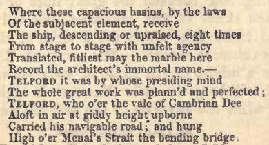
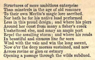
92. Having conducted the
reader to Inverness by what is now the great thoroughfare, the canal, we
will, in concluding this section, devote a few pages to a more detailed
description of either side of Loch Ness.
The Great Glen forms the
chief line of communication between the opposite coasts of the north of
Scotland, and among the military roads formed between the periods of the
rebellions of 1715 and 1745, one was conducted along the south side of this
great valley. This, like the other military roads, was repaired and improved
by the Parliamentary Commissioners appointed for carrying into execution the
views of government regarding the improvement of the Highlands at the
commencement of this century, under whose direction also new lines of road
were formed along the opposite sides of Lochs Ness and Oich.
93. Along the space (of seven
miles) from Fort-Augustus to Inverinoriston, on the north side of Loch Ness,
the road is, for the most part, straight and level; and the shore of the
lake being low, the road keeps near the edge of the water, through long
avenues of hazel and birch. A good view of the fort and surrounding country
is obtained at about a mile's distance from the garrison; but a still better
one will be found from the rocks at the mouth of the river Oich.
At the opening of Glen
Moriston, the road beyond the inn of Invermoriston, a small but snug and
comfortable house, passes above the house of James Murray Grant, Esq.,
proprietor of the glen—an old-fashioned fabric modernised, beautifully
situated, surrounded with wooded parks, and encompassed by abrupt hills of
considerable altitude, altogether an appropriate residence for a Highland
chieftain. The traveller will enjoy an excursion of eight or ten miles up
Glen Moriston, which, for that space, is one mass of birch and pine, with
but few arable patches, and watered by a clear river, the banks of which
afford many glimpses of exquisite beauty. Immediately below the inn is a
picturesque waterfall ; the river, of considerable size, pouring its waters
from an open channel headlong into a confined duct of shelving rock, which
conveys them to the lake.
94. From Invermoriston to
Drumnadrochet the distance is thirteen miles, and the whole road one of
extreme beauty ; it generally proceeds at a considerable elevation above the
lake, through luxuriant, overhanging woods, where the profuse intermixture
of oak and ash, with birch and alder, adds much to the richness and tone of
colouring. Dark and dense masses of pine are frequently seen crowning the
lofty and craggy heights above; while beneath, the rowan and hawthorn trees
mingle their snowy blossoms, or coral berries, with the foliage of the more
gigantic natives of the forest. The road is, in part, overhung by the
fantastic branches of the yet youthful oak ; while the stately ash, rooted
in the steep declivities below, shoots up its tall, straight, perpendicular
stem, and with its scattered terminal foliage slightly screens the glassy
lake, or purple ground colour of the opposite hills; and the airy birch
droops its pensile twigs round its silvery trunk, "like the dishevelled
tresses of some regal fair." Here, as elsewhere, along the banks of the
lake, the sward and the underwood are alike most beauteous, the ground
carpeted in early summer with the primrose and wood anemone, violet, and
harebell; and as the season advances, the leafy green of the forest glade,
richly spangled with the modestly glowing and delicate corollas of the wild
rose, challenging comparison with any of the denizens of the shrubbery or
flower-garden. The dark-purpled heath in tufted wreaths presents itself
wherever an opening in the wood or a frontlet of rock allows ; while the
bracken, with its rich verdure, spreads itself over the ground, alike where
shaded by the green wood, or where sloping otherwise unclad to the base of
the rocky surmounting acclivities.
Along the north road are two
waterfalls of some claim to notice.
95. At Aultsigh, a
picturesque cottage, three miles from Invermoriston, a stream from behind
Mealfourvounie issues forth of a ravine of great depth, flanked on the east
side by the precipitous sides of the mountain base, which presents a bold
frontlet• not less than 1200 hundred feet in height, half-clad with
clambering, aged pine trees. The lower declivities, with the front to the
lake, and the opposite side of the defile, are shrouded in birch, of which,
and of hazel, holly, and alder, there are specimens of remarkable growth by
the burn course, which also exhibits several pleasing waterfalls. The
lowest—but a few yards off the road—offers a very perfect picture. At a
little distance in front of the fall, between low walls of rock, spanned by
an old arch graced with pendent festoons of ivy and eglantine, the burn
descends in a shelving rapid. Through the interlacing boughs of oak and
hazel appears the cascade, about twenty feet in height ; while behind a
wooded screen, surmounting the rocky channel of the stream, towers the bluff
frontlet with its scattered pines.
We have been the more minute
in describing this little scene, as it is associated with the Raid of
Cilie-christ (Christ's Church), one of the most sanguinary and brutal
affairs that stain the annals of an age of general blood and rapine. In the
early part of the seventeenth century, Angus, eldest son of Glengarry, had
made a foray into the Mackenzie's country : on his way home he was
intercepted by a gallant little band of Mackenzies, and slain, with a number
of his followers. Some time thereafter a strong party of Glengarry's men
were sent, under the command of Allan Mac Raonuill of Lundy, to revenge his
death. Allan led them into the parish of Urray, in Ross-shire, on a Sunday
morning, and surprised a numerous body of the Mackenzies assembled at prayer
within the walls of Cilliechrist, near Beauley ; for so was their little
chapel called. Placing his followers so as to prevent all possibility of
escape, Allan gave orders to set the building on fire. The miserable victims
found all attempts at escape unavailing, and were, without a single
exception—man, woman, and child—swallowed up by the devouring element, or
indiscriminately massacred by the swords of the relentless Macdonells,
whilst a piper marched round the church, playing an extemporary piece of
music, which has ever since been the pibroch of the Glengarry family.
The work of death being
completed, Allan deemed a speedy retreat expedient; but the incendiaries
were not to escape with impunity ; for the funeral pile of their clansmen
roused the Mackenzies to arms as effectually as if the fiery cross had been
carried through the valleys. Their force was divided into two bodies: one,
commanded by Murdoch Mackenzie of Redcastle, proceeded by Inverness, with
the view of following the pursuit along the southern side of Loch Ness ;
whilst another, headed by Alexander Mackenzie of Coull, struck across the
country, from Beauly to the northern bank of the lake, in the footsteps of
another party which had fled in this direction, with their leader, Allan Mac
Raonuill. The Mackenzies overtook these last, as they sought a brief repose
in some hills near the burn of Aultsigh. The Macdonells maintained an
unequal conflict for some time with much spirit, but were at length forced
to yield to superior numbers, and fled precipitately to the burn. Many,
however, missed the ford, and, the channel being rough and rocky, were
overtaken and slain by the 'victorious Mackenzies. Allan Mac Raonuill made
towards a spot where the burn rushed through a yawning chasm of considerable
depth and breadth. Forgetting the danger of the attempt in the hurry of his
flight, and the agitation of the moment, and being of an athletic frame, and
at the time half naked, he vigorously strained at, and succeeded in clearing
the desperate leap. One of the Mackenzies inconsiderately followed him, but,
wanting the impulse of those powerful feelings which had put such life and
mettle into Allan's heels, he had not the fortune to reach the top of the
bank grasping, however, the branch of a birch tree, he hung suspended over
the abyss. Mac Raonuill, observing his situation, turned back and lopped off
the branch with his dirk, exclaiming, "I have left much behind me with you
to-day ; take that also." Allan got considerably a-head of his followers;
and, having gained the brink of the loch, bethought him of attempting to
swim across, and, plunging in, he lustily breasted its cool and refreshing
waters. Being observed from the opposite side, a boat was sent out, which
picked him up.
The party of the Macdonells,
who fled by Inverness, were surprised by Redcastle in a public-house at
Torbreck, three miles to the west of the town, where they stopped to refresh
themselves : the house was set on fire, and they all, thirty-seven in
number, suffered the death they had in the early part of. the
day so wantonly inflicted.
At Ruisky, a small
public-house opposite Foyers, and about five miles from Invermoriston, there
is a ferry across the lake, by which the Fall of Foyers can be conveniently
visited.
Immediately west of Ruisky, a
torrent called Authguithas (Aultghuis) rushes almost vertically down the
hill face, in a prolonged cataract, partially screened by trees.
96. Urquhart Castle has been
already described. Glen Urquhart, one of the richest and most beautiful of
our highland valleys, opens up from the lake about fourteen miles from
Inverness: its length is about ten miles. From its head, at Corrymony, it
gradually widens out ; and about its centre it contains a small circular
lake, Meiklie, adorned by the houses of Lakefield (Ogilvy), Lochletter, and
Sheuglie. At the lower extremity of the lake, the sides of the glen
approximate, and the winding strath below continues rather narrow and
confined, widening again, however, towards the entrance, and there
exhibiting considerable tracts of rich cultivated land carried to the very
hill tops. The gently sloping banks of the lake above the fertile fields of
Lakefield and Lochletter, and the more steep declivities between it and Loch
Ness, are clad to their summits with luxuriant and graceful birch woods,
while the frequency of cultivated spaces, and the fertility of the soil,
give a peculiar richness and gladsomeness to this beautiful valley. The
elegant shrub Prunus padus or bird-cherry, grows here to a great size,
especially about the house of Polmaily, (General Cameron), and more
abundantly than in any other valley we have seen. Indeed, both the soil and
climate appear admirably adapted for the rearing of ornamental and fruit
trees ; and they give birth to an exuberant vegetation, especially indicated
by the rankness of the stately and gorgeous Digitalis lining the road sides.
The greater part of Glen Urquhart is in the possession of the Grant of
Grant, or Seafield family, who have a residence in it called Balmacaan.
It is a cause of much regret
that the beauty of this charming valley has of late been materially impaired
by the ruthless sacrifice of the greater part of its fine birch woods, and
that not only without the slightest benefit, but to the absolute pecuniary
Ioss of the noble proprietor, whose forester, in an evil hour, entered into
a contract for the supply of a quantity of birch, so large that it is
scarcely possible to fulfil it from the Seafield estates in this quarter,
and, by some lamentable oversight, at a price which will actually not
suffice to pay for the cost of delivery. And this for the most unromantic
purpose of manufacturing bobbins for Glasgow cotton mills! How outrageous a
proceeding ! Why will proprietors persist—for this is by no means a solitary
instance—in permitting subordinates to mar, at one fell swoop, natural
features, in the development of which, for the delight of mankind, the
benignant Artificer of the Universe has seen fit to expend, it may be, a
century of years? The public mind revolts against the unguarded,
rough-handed, violation of characteristics which length of time have so
identified with a country side, that the public eye, and the public taste,
have acquired a sort of prescriptive right to their preservation.
At the mouth of the glen
there is a large and excellent inn, called Drumnadrochet. An excursion of
four or five miles up the glen should not be omitted ; and the pedestrian
should follow a by-path, which, opposite the farm-house of Delshangie,
strikes across the skirt of the hill, and gives a commanding view of the
little lake and its imposing houses. About two miles from the inn, a small
burn, descending from the flank of Mealfourrounie, falls over a lofty ledge
of rock, forming what are called the Falls of Ghivach or Dhivach: were the
body of `eater not so insignificant, they would, from their height, and the
deep, confined, and wooded bed of the stream, nearly rival the magnificent
falls of Foyers, on the opposite side of the lake. The base of the fall can
be best attained by following the northern bank of the stream, which passes
a little below the house of Balinacaan; but it is not at all times very easy
of approach, as a branch streamlet crosses the path, and the burn course
must latterly be threaded. A pathway will be found along the opposite edge
of the ravine from the little bridge of Clunemore, which leads to a pretty
good point of view. The fall is in the direct route to Mealfourvounie,
should the traveller meditate a trip to its summit, which is here quite easy
of access, and affords a less laborious opportunity of a mountain view than
is generally the case, and is the work of a couple of hours from the fall.
A district road crosses the
hill from Drumnadrochet to the Aird at T3elladrum, a distance of about ten
miles ; and we trust that ere long the head of Glen Urquhart will be
connected with Strathglass, by an extension of the road over the intervening
space of about three miles. [Temple, indicated by the toll-bar and two noble
ash trees, may be assumed as the most probable site of one of the most early
churches in the Highlands, that of St. Maolrubha, built in the seventh
century, of "hewn oak," as mentioned in the Breviarium Aberdonense.]
97. The burn of Aberiachan,
nine miles from Inverness, presents, by the roadside, a succession of falls
of from ten to thirty feet in height, with clear basins below, and shelving
rapids between ; the channel lined by low rocks, and shaded by woods of
birch. Dochfour House (Baillie), already noticed, is an imposing new edifice
in the Italian style ; and a little way on, a granite obelisk, erected to
the memory of the late proprietor, Evan Baillie, Esq. A couple of miles from
Inverness the Moray Firth, lined by ranges of moderate size, of softened
character, open on the view, with a fertile plain and part of the town
between, and Fort-George in the distance.
98. The road from
Fort-Augustus, on the south side of Loch Ness, conducts across the shoulder
of Suchumin. The appearance of the country—the upper portion of an elevated
table-land, called Stratherrick—till we reach the river Foyers, which the
road crosses at Whitebridge, about four miles above the celebrated Falls of
Foyers, is uninteresting, and the road exceedingly hilly and tedious. Here
we would direct the traveller's attention to a sequestered spot in the
vicinity, of peculiar beauty, on the river Foyers. This is a secluded vale,
called Killin, which, besides its natural attractions, and these are great,
is distinguished as one of the few places where the old practice of
resorting to the "shieling" for summer grazing of cattle is still observed.
It is lined by steep mountain ranges, partially decked with birch, and
hanging mossy banks, shaded over with the deeper-tinted bracken ; but
passing more into naked cliffs, or strewed with broken fragments of rock,
intermingled with a scanty verdure sprouted with heath. At the north end
there is a small lake about a mile and a-half in length, and from one-third
to half-a-mile in breadth. The remainder of the bottom of the glen is a
perfectly level tract of the same width with the lake, and about two miles
and a-half in length, covered with the richest herbage, decked with numerous
wild flowers, and traversed by a small meandering river flowing through it
into the lake. The surface of this flat is bedecked with the little huts, or
bothies, which afford temporary accommodation to those in charge of the
cattle. About half-a-mile from the south end of the lake, Lord Lovat, the
proprietor, has erected a shooting-lodge; viewed from which, or from either
end, or from the top of a platform on the northeast side of the lake, fancy
could scarcely picture a more attractive and fairy landscape than this
sequestered vale, to which Dr. Johnson's description of "the happy valley,"
not inaptly applies. The milch cows, to the number of several hundreds, are
generally kept here from the beginning of June till the middle of August,
when they are replaced by the yeld cattle. In the little bothies, the young
girls in charge of the inilch cattle pass their peaceful and secluded
summers. These are very primitive structures of turf, each of a single small
compartment, entered by a low doorway ; from one side of which, a
breast-high turf screen, advanced a few feet, serves to protect the
bed-place from the draught, and a bench of the same material, along the
opposite wall, answers the purpose of chairs, and completes the arrangements
of the interior, excepting that a small inner recess, at one corner,
contains the dairy produce, which, we need hardly advise the thirsty
wayfarer, is here to be met with in profusion and perfection, and with a
welcome. A district road on the west side of the river now invades the
privacy of this retreat. On the opposite side, a rough footpath conducts
from Whitebridge.
99. Stratherrick is broad and
open, and bordered on the north by a wide elevated plain, and the whole
encompassed by granite hills shooting up into numerous naked summits ; while
similar lower eminences display themselves throughout the intermediate
space, which is covered with mingled meadow, arable, and moorland. Between
the falls and the strath of Stratherrick (a space of three or four miles)
the river Foyers flows through a series of low rocky hills clothed with
birch. They present various quiet glades and open spaces, where little
patches of cultivated ground are encircled by wooded hillocks, whose surface
is pleasingly diversified by nodding trees, bare rock, empurpled heath, and
bracken bearing herbage. The visitor who, from Inverness, means to return
there, may pleasingly vary his homeward route by following the course of the
Foyers for a few miles above the falls, and then descending Stratherrick to
Loch Farraline, and there turning off by the Inverfarikaig road, through the
pass already alluded to, when he reaches Loch Ness side, two miles east of
the General's hut, at Inverfarikaig, where he can bait; and again at Dores,
if so disposed. The distance is thus lengthened eight or ten miles; making
it rather a long day's journey from and back to Inverness.
For a description of the
fall, we refer the reader to the steamer's course along Loch Ness.
100. The General's Hut, as
the small inn (18 miles from Inverness) near the Fall of Foyers, is called,
from the circumstance of General Wade having had his head quarters in this
vicinity when forming the military road along Loch Ness, has been
considerably improved by what it was some 20 years ago. But it is still far
from affording suitable accommodation at a spot so much frequented as the
Falls of Foyers. No doubt, a large proportion of tourists content themselves
with a flying visit from the steamers. But this is still a favourite
pleasure drive for parties from Inverness, and would be still more so, were
there anything half so attractive as the very comfortable establishment at
Drumnadrochet, on the opposite side of the lake; for the character of the
intermediate scenery, though different, from the effect of greater
inequality in the line of the northern roadway, is such as makes the whole
excursion a very agreeable one.
101. We would recommend
travellers, whom the falls attract in this direction, to explore for a short
way the road which strikes off at right angles from the lake on the west
side of the Farikaig, about three miles from the Foyers, on the Inverness
road. It leads by the side of a brawling torrent, along the bottom of a
narrow and deep defile, the pass of Inverfarikaig, which leads into
Stratherrick at Loch Farraline. Woods of birch line the bottom and mantle
the slopes of the ravine, from which a few groups and single trees extend
along the face of the precipitous rocks above, waving their graceful twigs
like flowery garlands along the mountain's brow. At the entrance of the pass
from Loch Ness the eastern side consists for a considerable space of a range
of perpendicular and rugged precipices, and towards the lake the high and
broad frontlet of the "Black Rock," surmounting an ample and birch clad
acclivity, terminates the range of precipices, and on its summit we discern
the green-clad walls of the ancient vitrified fort of Dundarduil.
102. To Dores the road hence
continues for eight miles close by the water's edge, passing for about
one-half of this space through a succession of straight avenues of hazel,
mingled with birch, alder, and ash trees, and rarely presenting favourable
views of the lake. The closeness of the wood and coppice, yielding still and
prolonged vistas, bestows a character of peculiar repose, freshness, and
beauty on the scenery, which has called forth the following eulogium from
the pen of Dr. Macculloch:—"If hence from Foyers to Inverness the .country
presents no picturesque scenery, there is one part of the road which may
well redeem the whole; there is none such throughout the Highlands, so that
it adds novelty to beauty, a green road of shaven turf holding its bowery
course for miles through close groves of birch and alder, with occasional
glimpses of Loch Ness and of the open country. I passed it at early dawn,
when the branches were still spangled with drops of dew; while the sun
shooting its beams through the leaves, exhaled the sweet perfume of the
birch, and filled the whole air with fragrance."
103. Perhaps the finest view
to be obtained of Loch Ness is that which is exhibited, looking back from
the ascent from Dores, with the wooded parks of Aldourie as a foreground.
The road onwards leads
through the policies of Ness Castle (Lady Saltoun), and past the house of
Holm (Mackintosh), and as it approaches the town, runs by the wooded islands
of the Ness, the county buildings and jail crowning the castle-hill on the
river's brink with an imposing mass of castellated masonry, forming for some
time, as we approach, a conspicuous and striking object. |