|
As part of the inaugural Perthshire
Archaeology Week, on the 15 June 2003 Mark Hall, of Perth Museum and Art
Gallery led an enthusiastic party around the early medieval landscape of
Struan. We looked at three elements in particular: 1.The Garry-Errochty
river junction and placenames; 2.Struan Kirk and Kirkyard; 3.Struan mound.
This article is by way of a brief account of that walk-and-talk.
The Garry-Errochty river junction and
place names.
We began our historical exploration
where the waters of the River Garry and the Errochty Water meet and thus
define a rather peninsula-like piece of land on which Struan Kirk stands.
Struan drives from the Gaelic word sruthan, meaning 'place of
streams, confluence' and so is an eloquent description of the meeting of
the Garry and the Errochty. The word Errochty is also of Gaelic origin and
means 'Assembly place'. Garry, incidentally, may derive from the Gaelic
for thicket or den or it may be from the name Garaidh, an Irish hero. That
these names have a Gaelic origin suggests that they were named at the time
of Gaelic settlement from the West Coast (present day Argyll, in the past
Dalriada) during the 7th/8th century, giving rise to the Gaelic kingdom of
Atholl. The place name Struan may seem no more than a prosaic description
of a place where two rivers meet but it is clear that such places had a
notable value to early medieval peoples. A Pictish or British equivalent,
Aber, is one of the commonest surviving such place name elements,
meaning 'at the confluence of' (e.g Aberfeldy, Abernethy and Aberdeen).
The name Struan occurs much more rarely (in part because river names often
retain their older names even during periods of extensive immigration) but
there is a further example in Perthshire, with the variant spelling of
Strowan, near Crieff. In the past Strowan and Struan were clearly
interchangeable spellings of the same word: both are at various times used
to name both places. What is particularly interesting about Strowan and
Struan is that both are places where the meeting of the rivers (in
Strowan's case the Earn and the Glascorrie Burn) are marked by the
presence of an early medieval church site and early medieval or Pictish
sculpture.
Struan Kirk and Kirkyard
Although the present Kirk is a 19th
century rebuild there are several clues to the presence of a much earlier
Church on the site. The circular shape of the churchyard: although it does
not appear circular today it is clear from old maps that the churchyard
has gradually been reduced in size and given a rectangular shape. A
probably 18th century map of Struan (in Blair Castle Archives) in
particular suggests that the churchyard was formerly much more rounded in
shape. As a rule of thumb a round or circular churchyard indicates an
early medieval date for the origin of that churchyard. The roundness or
circularity may have been a reflection of the near universal idea of the
sacred circle.
The dedication to St Fillan: the
origins and identity of St Fillan are obscure. There are approximately 20
saints with the name Fillan commemorated in early Irish written sources.
Certainly by the 9th century there was a strong cult of St Fillan in what
is now West Perthshire, with a particular focus in Glen Dochart and Upper
Strathearn. The Fillan in question seems to have been someone born in
Ireland, possibly of royal lineage, and who came to Pictland as a
missionary. The cult of St Fillan continued through the later medieval
period and was certainly boosted by the patronage of King Robert I. Saints
calendars from the end of the Middle Ages indicate two Fillans in
Scotland, with feasts on 20 June and 9 January. These could though be a
confusion of the birth and death dates (important because it marked the
point at which sainthood was gained) of the same Fillan. Allied to the
dedication is a long established fair named (in the Gaelic) after St
Fillan, Feill Faolan. This was held on the first Friday after New Year's
Day, probably to coincide with the 9 January feast day. The fair was held
on the field west of the Church, known as croft an' taggart or the
'Priest's croft/field'. From the early medieval period it was common for
there to be a strong link between fairs and the church and this seems to
be a good example of the practice.
There is one more piece of evidence
relating to St Fillan, an early medieval handbell named after the saint
(though at times it was also known more affectionately as the Buidhean, or
'the little yellow one'). Such cast, iron and bronze hand-bells were a
common feature of the early church and several examples survive from
Perthshire. The bell is unlikely to have been associated directly with St
Fillan and should be seen as part of the cult of St Fillan that was
practised in Struan in the 9th/10th/11th centuries. So it is St Fillan's
bell in the sense that it belonged to the church and community of St
Fillan in Struan. It was kept by the church and remained in some kind of
use (possibly as a 'deid-bell' and so chimed when a parishioner died or at
the head of a funeral procession) until the 19th century when William
McInroy of Lude gave the church a new bell in exchange for St Fillan's,
which he kept at Lude House. There it remained until 1939 when the house
and its contents were auctioned-off. The bell was purchased by
philanthropist whisky-millionaire A K Bell on behalf of Perth Museum and
Art Gallery. It is currently on display in the Human History Gallery of
the Museum.
Early medieval sculptures: also of
key relevance to our understanding of the development of Christianity in
the area is the survival of three Pictish or early medieval sculptures.
All have been found, at various times, in the churchyard. Two of them are
simple, quartzite-slate pillar-like stones incised with simple crosses.
The first of these was found in 1868 during the digging of a grave. It
stands in the middle of the churchyard and with careful inspection, its
two crosses can still be seen. The second has been known since the end of
the 19th century and is built into the west wall of the churchyard. It is
difficult to find and the cross has suffered some damage since it was
recorded at the end of the 19th century. Such carvings are generally seen
as a mark of Christian missionary work in what is now Scotland between the
6th and 9th centuries. Use as burial markers are a somewhat remoter
possibility. The third piece of sculpture was known by the 19th century
when it stood in the churchyard, leaning against the south wall of the
church. In the early 1970s, it was moved inside the church, where it now
stands, for its greater protection. It is a large, irregularly shaped slab
of schistose slate incised on one face with Pictish symbols. Clearly
visible is a double-disc and a z-rod but the symbol next to it has been
largely lost and its identity cannot be determined. The first drawing of
the stone is that done for John Stuart's The Sculptured Stones of
Scotland, published in 1856. Although the drawing was published upside
down it records additional details now lost, suggesting that the only
partially surviving second symbol may have bee the so-called 'flower'
symbol and that there was a third symbol that was even then indistinct and
certainly lost by the time Allen and Anderson's Early Christian Monuments
of Scotland was published in 1903. These so-called Pictish symbols are a
unique feature of early medieval sculpture in Scotland but their precise
meaning remains far from clear. There are many theories that try to
explain them: family badges, territory markers, burial markers, marriage
or alliance signifiers, some other form of specific symbolic language, a
reaction to the process of Christian conversion etc; but the prize of
certainty remains elusive. The main geographical focus for the symbol
stones is what might be termed Eastern Pictland, i.e. from the Forth
northwards and excluding the West Highlands and Islands. In this area
there are currently some 160 known sets of symbols. The z-rod (really a
backwards z) and the double-disc occurs around 51 times as a pair (and
each also occurs as separate symbols). Most to them are further north and
east of Struan, notably in Aberdeenshire.
Struan mound.
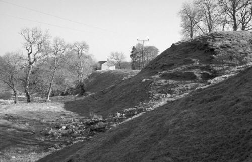
The third crucial element in the
landscape around Struan Kirk is the mound, which lies a few yards to the
north-west of the Kirk. This mound has long been known as Tom an Tigh
Mhoir - the mound of the great house. This Gaelic name may however be of
comparatively recent origin, to explain the mound, the original purpose of
which had been forgotten. In 1890 the antiquary MacIntosh-Gow recorded
that on top of the mound the presence of clearly visible building
foundations, said to be the remains of a house built by a local Laird but
never finished apparently because a neighbour over the river Garry built a
much higher castle. However the nature of the mound is such that if anyone
should try and rather foolishly build on it they would soon find that they
had no room and no weight bearing stability.
The mound measures approx. 20 foot
high and is approx. 75ft in diameter across the base and 55ft across the
top. It is generally held to be an early stronghold of the Chiefs of Clan
Donnachaidh and in a survey of mottes in Scotland published in 1972 (and
republished in 1985) it is accepted as being a motte. However there are a
number of factors that suggest that it may not be a motte at all but
rather an assembly mound. The factors that work against its being a motte
can be listed as follows:
Size: superficially it does look
quite large but the available area to be built on is rather small when
compared with other mottes and when this is set alongside the subsequent
points it is even more telling.
Ditch: there is no defensive ditch
surrounding the mound nor any sign that there ever was one. There is a
partial ditch of very shallow depth which runs around the northern
perimeter which seems rather like a later addition possibly for drainage
purposes?
Location: the mound is built-up
from the steep bank of the river Garry, which would make it structurally
unsound - especially if built upon - particularly during flooding and high
river levels.
Spring: the sloping river-bank on
which it is built is also the location of a spring, making it even more
susceptible to slippage. This spring was long revered as the well of St
Fillan and tradition records that a wooden statue of St Fillan (kept in
the Kirk) was ritually dipped in the well at times of drought in the hope
of bringing rain. In the early 18th century the then incumbent Minister
John Hamilton, found this to be an unpalatable vestige of Catholic belief
and so had the statue smashed and thrown into the Garry.
There are still difficulties with
identifying what the mound was used for and it clearly did seem to have
supported some form of structure as lines of walls can still be seen on
the mound. However it is possible that these relate to the construction of
the mound itself or to a small building added at a much later date or a
building started but abandoned. It is a strong possibility that a
structure that has stood for as many centuries as the mound has had more
than one episode of use and that what we see today is a conflation of use,
re-use and adaptation. Given its physical appearance its location and its
landscape context (including the early church and the placenames) it seems
highly likely that the mound was originally constructed (or adapted) as a
mound of assembly and /or judgement. Such mounds (sometimes known as moot
hills) can be purpose built or adaptations of existing man-made or natural
mounds. Such mounds of assembly are often associated with a church and
seem to occur quite widely from the 9th/10th century. There seem to be two
(not always) distinct traditions, Scandinavian (for example Govan on the
Clyde and Tynwald on the Isle of Man) and Irish/Gaelic/British (for
example Scone, Perthshire and Tara in Ireland). There also seems to be a
wide range of mound sites, some beside churches, some with churches upon
them and their precise subtleties of meaning require further study.
Examples include Kirkinch (nr. Meigle), Angus; Eassie, Angus; Caputh,
Perthshire; and La Hogue Bie, Jersey (where the church is built on top of
a Neolithic burial mound). Caputh is notable for having been a moot-hill
that was then use, from the 16th century, as the site for a new parish
church and burial ground. It is close to Murthly (which means 'big
mound'), the two places being on opposite banks of the river Tay, and from
where three pieces of early medieval sculpture have been found during the
last 100 years or so. If such sites also came to be linked with local
lordships it is possible that the mound at Struan may be suggestive of an
early thanage there, part of the lordship of Atholl.
As many readers of this Annual will know
Struan is part of the heartland of the Robertsons/Clan Donnachaidh.
Certainly they would have been important patrons of Struan Kirk in the
later medieval period (and beyond), would have practised the cult of St
Fillan and may possibly have made some use of the mound. However the
purpose of this short article has been to show that Struan has a much
longer history than its association with the Robertsons and the Clan's
first chief, Fat Duncan. Five hundred years and more before Duncan Pict
and Scot were learning to live with each other, being converted to and
practising Christianity and establishing their mechanisms of governance
and social control.
by Mark Hall
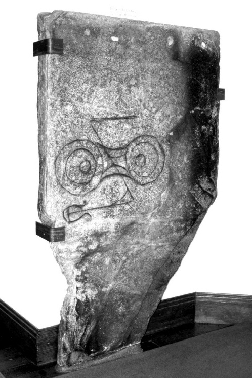
Struan Symbol Stone
Further Reading
For those interested many of the points
raised in this account can be followed up in the following books and
articles.
J Romilly Allen and Joseph Anderson, The
Early Christian Monuments of Scotland, 2 volumes, Pinkfoot press,
Balgavies, 1993 (originally 1903). [p.285-6 for the symbol stone; p.343
for the cross-incised stones].
George F Black The Surnames of Scotland,
originally published 1946, reprinted Birlinn 1996. [Concise entries for
Robertson and Donnachie].
Cormac Bourke, The handbells of the
early Scottish church, in Proceedings of the Antiquaries of Scotland 113
(1983), 464-8.
Stephen Driscoll, The Archaeological
Context of Assembly in Early medieval Scotland - Scone and its Comparanda,
in A Pantos and S Semple Assembly Places and Practices in medieval Europe,
forthcoming.
Katherine Forsyth, Some thoughts on
Pictish Symbols as a formal Writing System, in David Henry the worm the
germ and the thorn Pictish and related studies presented to Isabel
Henderson, Pinkfoot press, Balgavies, 1997.
Sally Foster Picts, Gaels and Scots,
Historic Scotland/Batsford, London, 1996.
Mark Hall, Isabel Henderson and Ian G
Scott, The Early medieval Sculpture from Murthly, Perthshire: An
Interdisciplinary Look at People, Politics and Monumental Art, forthcoming
in the proceedings of 2003 conference Able Minds and Practised Hands.
[Includes a discussion of mounds and their association with churches].
James Macintosh Gow, Holiday Notes in
Athole, Perthshire, in Proceedings of the Society of Antiquaries of
Scotland XII (1890), p.382-87. [Struan at p.383-85].
Mark Hall, Katherine Forsyth, Isabel
Henderson, Ross Trench-Jellicoe and Angus Watson, Of Makings and Meanings:
Towards a Cultural Biography of the Crieff Burgh Cross, Strathearn,
Perthshire; in Tayside and Fife Archaeological Journal 6(2000) 154-88.
[Includes a discussion of the Strowan/Struan place name and a site
comparison].
George and Isabel Henderson, The Art of
the Picts. Sculpture and Metalwork in Early medieval Scotland, forthcoming
in 2004.
Isabel Henderson Early Christian
Monuments of Scotland Displaying Crosses and No Other Ornament, in Alan
Small The Picts A New Look at Old Problems, Dundee 1987. [Key introduction
to the subject of simple cross-incised stones].
John Kerr, Church and Social History of
Atholl, Perth & Kinross Libraries, Perth, 1998. [Useful overview of the
development of the parish of Struan]
John Kerr, The Robertson Heartland,
reprinted from the Transactions of the Gaelic Society of Inverness LVI, in
1992. [Useful overview of the Struan area but with a more detailed
coverage of the Robertson link]
Alexander Laing, Notice of Early
Monuments in the Parish of Strowan, Blair Athole, in Proceedings of the
Society of Antiquaries of Scotland VII (1868), p.442-4. [Descriptions of
the cross-incised stones].
Alastair Mack, Field Guide to the
Pictish Symbol Stones, Pinkfoot Press, Balgavies, Angus 1997. [p.6 for the
double-disc and z-rod symbol; p.21-2 for the flower symbol].
E H Nicoll A Pictish Panorama, Pinkfoot
Press, Balgavies, 1995. [A useful introduction to things Pictish].
David Stuart, The Sculptured Stones of
Scotland, volume II, Aberdeen, 1856. [Struan symbols stone is plate CII
no. 2].
Simon Taylor, The Cult of St Fillan in
Scotland, in Thomas Liszka and Lorna Walker The North Sea World in the
Middle Ages, Studies in the Cultural history of North-Western Europe, Four
courts Press, Dublin, 2001. [Detailed assessment of the identity and cult
of St Fillan].
Charles Taylor, The Early Christian
Archaeology of North Britain, Oxford University Press (for Glasgow
University), 1971. [Includes a discussion on the nature of early medieval
cemeteries and churches, including the circularity of churchyards]
W J Watson The Celtic Placenames of
Scotland, originally published 1926 reprinted Birlinn, Edinburgh, 1986. |


